
Limnomysis benedeni Czerniavsky, 1882
|
publication ID |
https://doi.org/ 10.11646/zootaxa.4142.1.1 |
|
publication LSID |
lsid:zoobank.org:pub:FA423164-276C-44B0-A417-8E97AC3DF0AA |
|
DOI |
https://doi.org/10.5281/zenodo.6088681 |
|
persistent identifier |
https://treatment.plazi.org/id/03B9BA4E-1820-FFF7-CAF6-FBDEFA62408F |
|
treatment provided by |
Plazi |
|
scientific name |
Limnomysis benedeni Czerniavsky, 1882 |
| status |
|
Limnomysis benedeni Czerniavsky, 1882 View in CoL
Fig. 19 View FIGURE 19
Short selection from 27 synonymy statements with a total of 416 references:
Mysis relicta var. pontica Grebnitzky (in synonymy by Czerniavsky 1882a) (nomen nudum).
Limnomysis Benedeni Czerniavsky, 1882a: 1887 View in CoL ; Sars 1893; Chirica 1914; Colosi 1930.
Limnomysis Brandti Czerniavsky, 1882a: 1887 View in CoL ; Sowinsky 1904 (partim: 457).
Limnomysis Schmankewiczi Czerniavsky, 1882a: 1887 View in CoL ; Sowinsky 1895, 1904.
Onychomysis mingrelica Czerniavsky, 1882a: 1887 View in CoL ; Sowinsky 1904 (partim: 141, 338); ITIS 2014.
Limnomysis benedeni: Zimmer 1915a View in CoL ; Derzhavin 1924; Komarova 1991; Kelleher et al. 1999; Daneliya 2002; Daneliya et al. 2012; Wittmann et al. 2014; Zettler 2015.
Mysidella bulgarica Valkanov, 1935: 1936a, 1936b .
Limnomysis brandti View in CoL : ITIS 2014.
Limnomysis schmankewiczi : ITIS 2014.
Material examined (hand net, leg. K. J. Wittmann):
Mediterranean drainage (southern France, Rhône system, 15–19 June 2009). 2 F ad. 7.3–8.3 mm, among ~30,000 Mesopodopsis slabberi and 3 Diamysis lagunaris , estuary of the Petit Rhône at Tiki, same sample as indicated above for M. slabberi ; 1 F subad. 5.5 mm, 1 F imm. 4.7 mm, estuary of the Grand Rhône at Port St. Louis , Rhône-km 323.2, left bank, 43.3828N 004.8073E, sea distance 6 km, 0.5–4 m depth, among Potamogeton and on filiform algae on concrete walls and wrecks, v = 0 m/s, stratified salinity S = 0.1–3.5, 473–6300 µS/cm, near surface, 22.5°C, pH 7.63, 11°d, 7.35 mg O2/l, 17 NTU GoogleMaps ; 1 M ad. 6.0 mm, 1 F imm., 1 juv., (canal) Liaison Rhône— Fos, 100 m after branching off from Rhône River , 43.4217N 004.7470E, altitude 1 m, sea distance 13 km, 0.5–2.5 m depth, among Potamogeton , Elodea , and on boulders, v = 0 m/s, S = 0.2, 574 µS/cm, 23.0°C, pH 7.73, 11°d, 7.89 mg O2/l, 36 NTU GoogleMaps ; 6 F ad. 7.1–8.5 mm, 4 M ad. 6.0– 8.2 mm, Canal d'Arles à Fos, in Arles, small basin at the Nouveau Pont, 50 m above the first lock after having branched off from the river at Rhône-km 283, 43.6725N 004.6185E, altitude 5 m, sea distance 47 km, 0.2–2 m depth, among bank vegetation, Trapa , Myriophyllum , and Carex , v = 0 m/s, S = 0.1, 390 µS/cm, 22.1°C, pH 7.44, 10°d, 6.67 mg O2/l, 20 NTU, NHMW reg GoogleMaps . no. 25709; 1 M ad. 7.2 mm, Bras de l'Ardoise, Port 2— Port de la Plaisance, right bank at Rhône-km 214, 44.1051N 004.7058E, altitude 28 m, sea distance 112 km, 0.3–2 m depth, among Myriophyllum , Elodea , and on filiform algae on stones, v = 0.1–0.3 m /s, S = 0.1, 434 µS/cm, 22.7°C, pH 7.43, 12°d, 6.68 mg O2/l, 16 NTU GoogleMaps ; 1 F ad. 8.1 mm, old branch of Rhône River at Le Pal de Fer (2.5 km upstream of Viviers), right bank at Rhône-km 163.5, 44.5078N 004.6881E, altitude 64 m, sea distance 161 km, 0.2–1.5 m depth, among bank vegetation and Myriophyllum , v = 0.1–0.3 m /s, S = 0.1, 395 µS/cm, 21.4°C, pH 7.83, 10°d, 9.44 mg O2/l, 5 NTU GoogleMaps ; 4 F ad. 6.5–8.3 mm, downstream of Meysse, at corner with Old Rhône, 300 m downstream of Barrage de Loriol, right bank at Rhône-km 135.8, 44.5923N 004.7229E, altitude 70 m, sea distance 169 km, 0.2–1.5 m depth, among Potamogeton and from filiform algae on stones, v = 0.1–0.3 m /s, S = 0.1, 356 µS/cm, 20.3°C, pH 7.68, 10°d, 7.52 mg O2/l, 20 NTU GoogleMaps ; 3 M ad. 5.6–6.3 mm, 1 M subad., 2 imm., great bay in Tournon-sur-Rhône, right bank at Rhône-km 90.4, 45.0729N 004.8255E, altitude 118 m, sea distance 234 km, 0.2–1.8 m depth, from filiform algae on stones, v = 0 m/s, S = 0.1, 303 µS/cm, 23.2°C, pH 7.78, 10°d, 8.59 mg O2/l, 11 NTU GoogleMaps ; 3 F ad. 7.7–8.5 mm, 3 M ad. 5.9–8.1 mm, 1 F subad., 2 juv., right bank of Rhône River at km 34, this is shortly downstream of the Barrage de Vaugris, 45.4949N 004.8247E, altitude 144 m, sea distance 287 km, 0.5–2 m depth, among Potamogeton and on boulders, v = 0.1–0.2 m /s (sheltered microhabitat), S = 0.1, 371 µS/cm, 20.6°C, pH 7.51, 10°d, 7.07 mg O2/l, 17 NTU GoogleMaps ; 3 F ad. 6.3–8.4 mm, 1 M ad. 7.9 mm, 2 juv., Lyon, Port Edouard Herriot at Rhône-km 3.3, 45.7056N 004.8430E, altitude 160 m, sea distance 320 km, 0.5–2 m depth, among Elodea , Potamogeton , and on stones with coat of algae, v = 0 m/s, S = 0.1, 393 µS/cm, 20.8°C, pH 7.79, 14°d, 8.38 mg O2/l, 6 NTU GoogleMaps ; 4 M ad. 4.9–7.3 mm, 4 imm., Villefranche-sur-Saône, right bank of Saône River at km 37, basin at the Chemin du Colombier, 45.9619N 004.7389E, altitude 166 m, sea distance 360 km, 0.3–1 m depth, among Elodea and Myriophyllum , v = 0 m/s, S = 0.1, 408 µS/cm, 22.7°C, pH 7.64, 16°d, 13.24 mg O2/l, 24 NTU GoogleMaps ; 2 M ad. 5.6–6.5 mm, Mâcon, right bank of Saône River at km 79.5, 46.2988N 004.8311E, altitude 165 m, sea distance 403 km, 0.5–2.5 m depth, from dirty Myriophyllum , Nuphar , and stones, v = 0 m/s, S = 0.2, 591 µS/cm, 22.1°C, pH 7.29, 16°d, 6.28 mg O2/l, 15 NTU GoogleMaps ; 2 F ad. 5.8–5.9 mm, 3 F subad., Chalons-sur-Saône, Zone Portuaire Sud at left bank of Saône River , at river-km 137, 46.7619N 004.8789E, altitude 172 m, sea distance 461 km, 0.3–2.5 m depth, from dirty Potamogeton and algae on stones, v = 0 m/s, S = 0.2, 601 µS/cm, 22.1°C, pH 7.29, 15°d, 9.74 mg O2/l, 12 NTU GoogleMaps ; 6 F ad. 5.7–7.5 mm, 1 M ad. 5.6 mm, 4 F subad., 1 F imm., Chalons-sur-Saône, yachting harbour at Saône-km 144, 46.7925N 004.8853E, altitude 173 m, sea distance 467 km, 0.3–2.5 m depth, from shore vegetation, Carex , algae on stones, and boulders, v = 0 m/s, S = 0.2, 583 µS/cm, 23.0°C, pH 7.01, 15°d, 8.05 mg O2/l, 9 NTU GoogleMaps .
Marmora Sea drainage ( Turkey). 191 F ad. 6.0- 7.6 mm, 141 M ad. 5.7-7.1 mm, 42 F subad., 28 M subad., 67 imm., 70 juv., NE-coast, (lagoon) Büyükçekmece Gölü, northern freshwater reach, 41.1041N 028.5614E, altitude 3 m, sea distance 10 km, 0–1.5 m depth, among roots of Salix and on boulders, v = 0 m/s, S = 0.2, 484 µS/cm, 21.5°C GoogleMaps , pH 8.10, 10°d, 6.19 mg O2/l, 15 NTU, 14 June 2006, NHMW 25710 View Materials ; 1 F ad. 8.9 mm, 1 F subad. 7.0 mm, NE-coast, (lagoon) Küçükçekmece Gölü , 41.0105N 028.7700E, at about sea level, sea distance 5 km, 0.5 m depth, on algae, stones, and boulders, v = 0 m/s, S = 6, 10000 µS/cm, 26°C, 1 July 1988 GoogleMaps ; 12 F ad. 5.7–8.6 mm, 5 M ad. 5.6–6.4 mm, 2 subad., 3 imm., NE-coast, small river near its mouth into (lagoon) Küçükçekmece Gölü , 41.0640N 028.7433E, altitude 2 m, sea distance 11 km, 0.3–0.5 m depth, among shore vegetation, v = 0.1–0.2 m /s, S = 0.3, 800 µS/cm, 27°C, 1 July 1988 GoogleMaps ; 62 F ad. 5.9–8.9 mm, 11 M ad. 5.9–7.6 mm, 13 subad., 16 imm., 2 juv., S-coast, (lake) Uluabat Gölü , near Karaağaç, 41.1943N 028.6150E, altitude 4 m, sea distance 54 km, 0.5 m depth, among macrophytes, v = 0 m/s, S = 0.1, 500 µS/cm, 30°C, highly eutrophic aspect, 5 July 1988, MHNG; 183 F ad. 5.8–7.9 mm, 129 M ad. 5.5–7.9 mm, 96 subad., 146 imm., 72 juv., same lake as above, at Eskikaraağaç, 41.1889N 028.6087E, sea distance 51 km, 1–2 m depth, from mud, Myriophyllum and Potamogeton , v = 0 m/s, S = 0.2, 528 µS/cm, 19.9°C GoogleMaps , pH 7.46, 8°d, 6.58 mg O2/l, 3 NTU, 13 June 2006 ; 2 F ad. 6.7–7.5 mm, 2 F subad., 2 imm., 3 juv., S-coast, small river Koca Dere , near Akçasusurluk, 40.2884N 028.4332E, altitude 4 m, sea distance 16 km, 0–1 m depth, among bank vegetation, v = 0.1 m /s, S = 0.1, 440 µS/cm, 27°C, 5 July 1988 GoogleMaps .
NE-Atlantic drainage (from the canal network connecting the river systems of Seine, Meuse, and Rhine, 29 June 2009). 1 F ad. 6.3 mm, 2 M ad. 6.4–7.0 mm, 2 imm., Canal de l'Est, branche Nord, between Troussey and Vertuzey, shortly upstream of Écluse no. 3 Frâsnes, 48.7159N 005.6723E, altitude 236 m, sea distance 711 km (Meuse) or 731 km (Seine), respectively GoogleMaps , 0.2–2.5 m depth, among Potamogeton , Myriophyllum , Elodea , and from filiform green algae on steel walls, v = 0–0.1 m /s, S = 0.1, 450 µS/cm, 23.5°C, pH 7.71, 13°d, 7.73 mg O2/l, 16 NTU; 2 F ad. 7.1–8.0 mm, 1 M ad. 7.2 mm, 1 F subad., 2 imm., Canal de la Marne au Rhin, near Pagny-sur-Meuse, at canal-km PK 115.0 , 48.6904N 005.7171E, altitude 243 m, sea distance 717 km (Meuse) or 734 km (Seine), respectively, 0.1–0.5 m depth, from filiform green algae on steel walls, v = 0–0.1 m /s, S = 0.1, 454 µS/cm, 22.5°C, pH 7.50, 13°d, 8.93 mg O2/l, 29 NTU, NHMW 25711 View Materials .
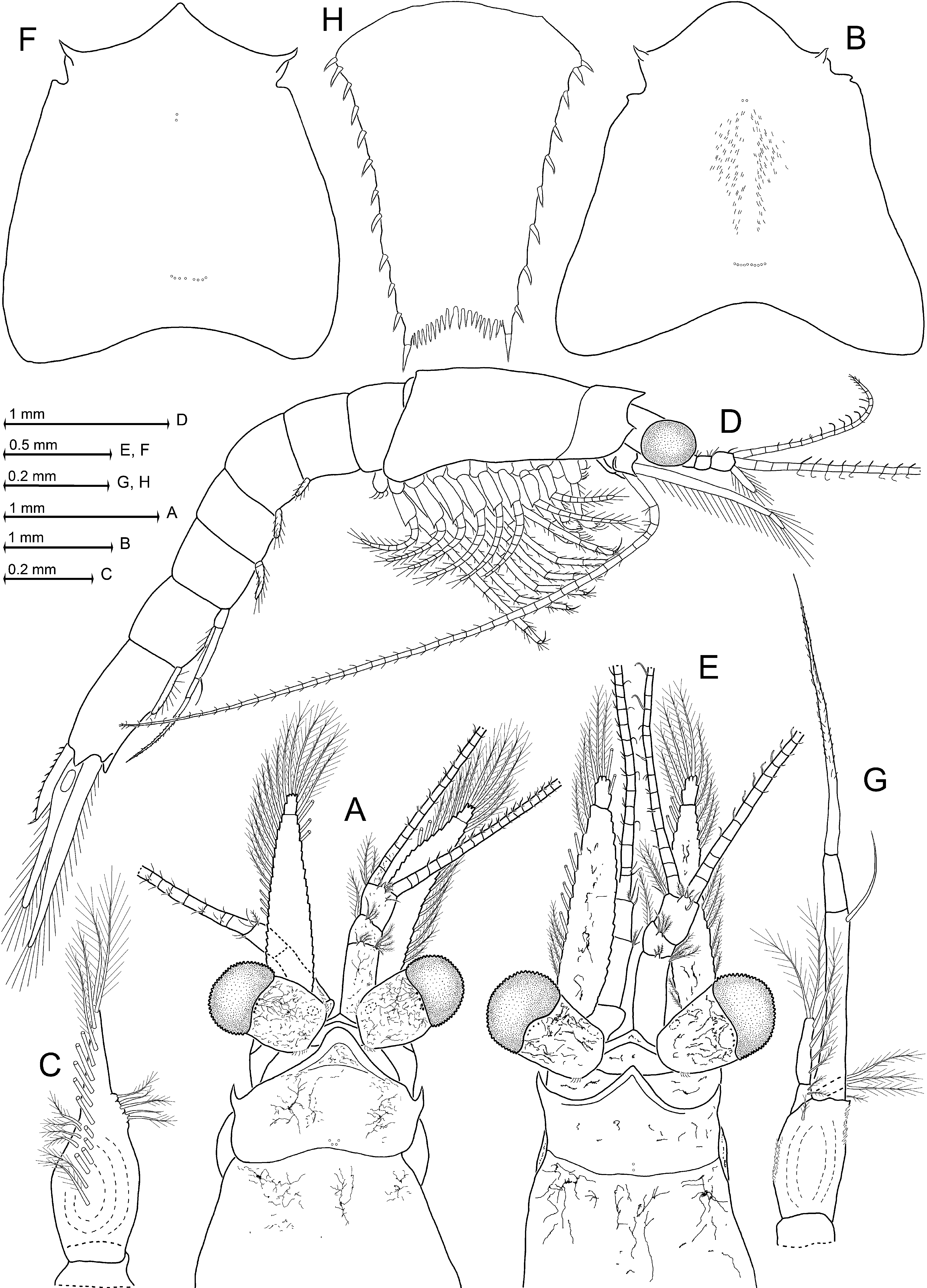
Description. Adult body size 5–12 mm. Eyes normal, length of cylindrical eyestalks without cornea is 1.1–2.0 times cornea diameter ( Fig. 19 View FIGURE 19 B). Eyestalk dorsally with series of 2–5 ommatidia shifted a small distance proximally, i.e. away from cornea ( Fig. 19 View FIGURE 19 B), similar to the findings in Diamysis fluviatilis ( Fig. 13 View FIGURE 13 A) and D. lacustris ( Fig. 13 View FIGURE 13 E). The eyestalk surface close to this ommatidia series is generally poorly pigmented but does not form a distinctly differentiated fenestra paracornealis such as found in D. lacustris ( Fig. 13 View FIGURE 13 E). Antenna with large posterior lobe ( Fig. 19 View FIGURE 19 E) containing end sac of antennal gland. Antennal scale 2-segmented, setose all around, terminally rounded in females ( Fig. 19 View FIGURE 19 D), whereas pointed with bent, setose tip in males ( Fig. 19 View FIGURE 19 A, E). Apical segment is 25–35% scale length. Carapace ( Fig. 19 View FIGURE 19 A) anteriorly broadly rounded; no rostral and subrostral processes; dorsal surface with 5–10 cervical pores in about V-shaped arrangement; and with 8–18 cardial pores in about linear, slightly curved, transverse arrangement. Total length of thoracic endopods, and also of their carpopropodus, remain roughly the same in series of endopods 3 to 6, and then decrease by a total of 20–25% along endopods 7 and 8; carpopropodus 3–8 always 3-segmented as in Fig. 19 View FIGURE 19 F. Flagellum of thoracic exopod 1 with 8–9 segments, that of exopods 2–8 each with 9–10 segments, not counting the large intersegmental joint between the 1- segmented basis and its multi-segmented flagellum; segmental counts tend to increase with increasing body size. Outer distal corner of basis always well rounded. All female pleopods and male pleopods 1, 2, and 5 reduced, fused, and styliform ( Fig. 19 View FIGURE 19 J). Third male pleopod also terminally fused, but with larger, 2-segmented sympod ( Fig. 19 View FIGURE 19 G). Fourth male pleopod with distinct sympod, endopod, and exopod ( Fig. 19 View FIGURE 19 H). Sympod 2-segmented. Setose endopod subbasally with terminally setose exite. Exopod longer, distinctly or indistinctly 3-segmented, not reaching base of uropods. Its median segment with 2–5 small, conical, spine-like setae along inner margin, and with series of 3–6 minute spine-like setae in submedian position, at a small distance parallel to outer margin ( Fig. 19 View FIGURE 19 H). Exopod usually stylet-like ( Fig. 19 View FIGURE 19 H), but alternatively may appear bifid or even trifid, which is commonly attributed to regeneration. These last variants usually rare, but may account up to 30% of adult males in certain populations ( Băcescu 1940, Kelleher et al. 1999). Scutellum paracaudale subtriangular, with slightly concave upper, and slightly convex lower margin; tip rounded ( Fig. 19 View FIGURE 19 K). Endopod of uropod with one spine below statocyst ( Fig. 19 View FIGURE 19 L). Statoliths composed of vaterite. Telson rather short and stout ( Fig. 19 View FIGURE 19 M), subtriangular to almost subrectangular, with small apical incision; incision well rounded to rounded subtriangular, apart from being armed with 4–10 laminar processes. Lateral margins of telson with 7–14 spines each.
Distribution ( Fig. 16 View FIGURE 16 ). Endemic in the Pontocaspian and in waters draining into the Marmora Sea ( Băcescu 1954, Kelleher et al. 1999, Wittmann & Ariani 2009). It inhabits mostly fresh- and oligohaline waters of lakes, lagoons, and river mouths. Here it dwells mainly among vegetation in shallow water (0.1–2 m, less frequently down to 10 m); maximum depth 68 m in the Caspian Sea ( Derzhavin 1939). Salinity optimum at S = 0–5, lower densities at S = 6–12 in river estuaries and lagoons along coasts of the Marmora and Black Seas ( Kelleher et al. 1999), also found in coastal 'marine' waters of the Caspian Sea up to S = 12.8 ( Sars 1907, Derzhavin 1939). It is potamophilous, avoiding current velocities> 0.5 m /s. Before human intervention, it penetrated only a few hundred kilometres into rivers ( Băcescu 1940).
For areal expansion of L. benedeni to tributaries of the North Sea, Baltic, and Mediterranean, see ‘Discussion’.


No known copyright restrictions apply. See Agosti, D., Egloff, W., 2009. Taxonomic information exchange and copyright: the Plazi approach. BMC Research Notes 2009, 2:53 for further explanation.
|
Kingdom |
|
|
Phylum |
|
|
Class |
|
|
Order |
|
|
Family |
|
|
Genus |
Limnomysis benedeni Czerniavsky, 1882
| Wittmann, Karl J., Ariani, Antonio P. & Daneliya, Mikhail 2016 |
Mysidella bulgarica Valkanov, 1935 : 1936a , 1936b
| Valkanov 1935: 1936 |
Limnomysis Benedeni Czerniavsky, 1882a : 1887
| Czerniavsky 1887: 1887 |
Limnomysis Brandti Czerniavsky, 1882a : 1887
| Czerniavsky 1887: 1887 |
Onychomysis mingrelica
| Czerniavsky 1887: 1887 |
Limnomysis Schmankewiczi Czerniavsky, 1882a : 1887
| Czerniavsky 1882: 1887 |