
Hanleya nagelfar ( Lovén, 1846 ), Kaas and Van Belle, 1985
|
publication ID |
https://doi.org/ 10.1080/00222933.2014.963722 |
|
DOI |
https://doi.org/10.5281/zenodo.4784142 |
|
persistent identifier |
https://treatment.plazi.org/id/513E7520-D31F-FFCA-FDDB-500CB19DFA6B |
|
treatment provided by |
Carolina |
|
scientific name |
Hanleya nagelfar ( Lovén, 1846 ) |
| status |
|
Hanleya nagelfar ( Lovén, 1846) View in CoL
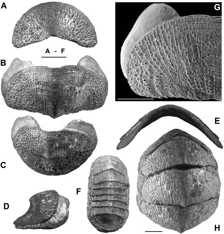
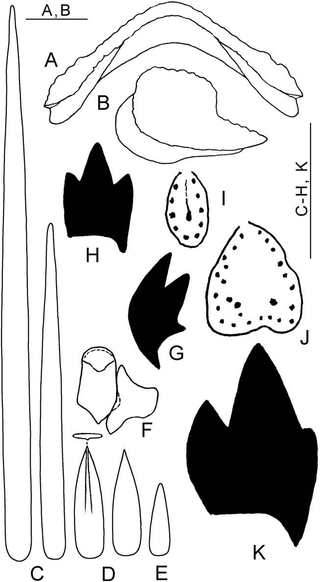
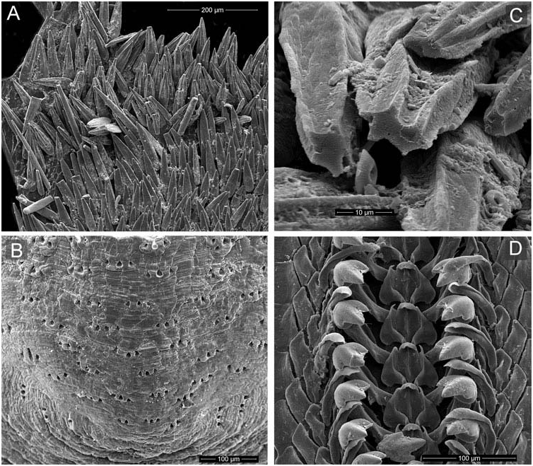
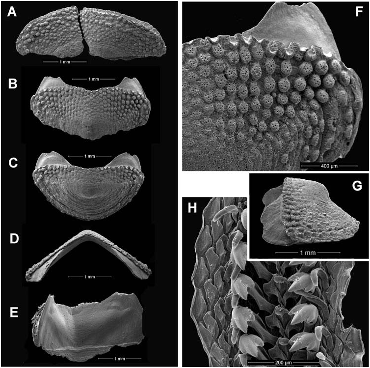
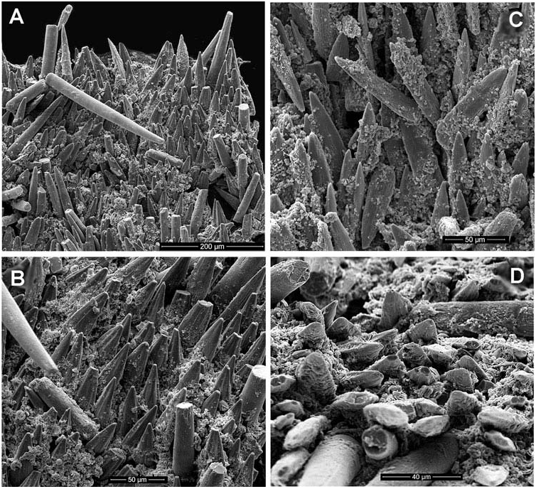
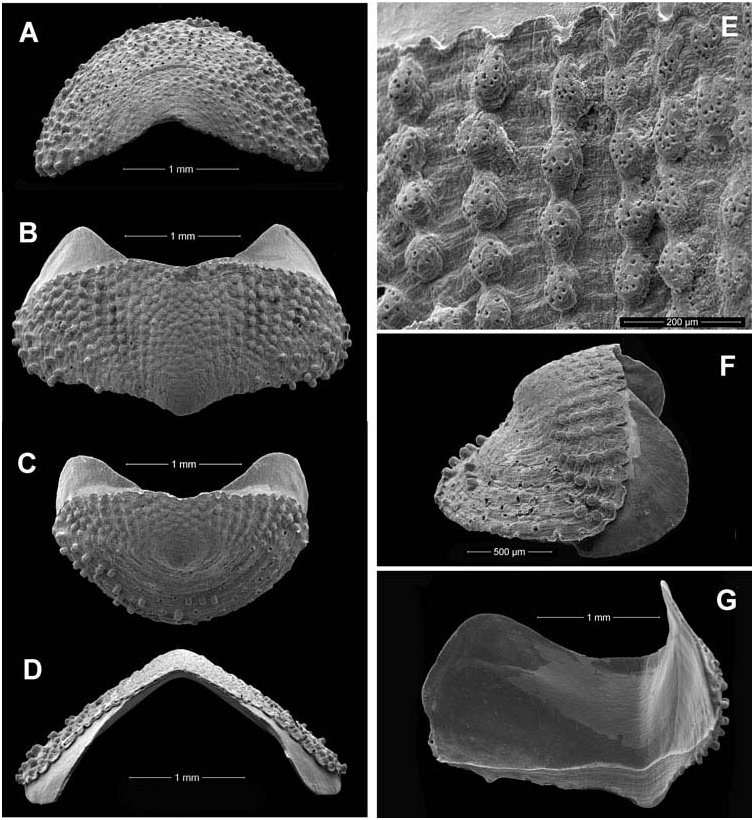
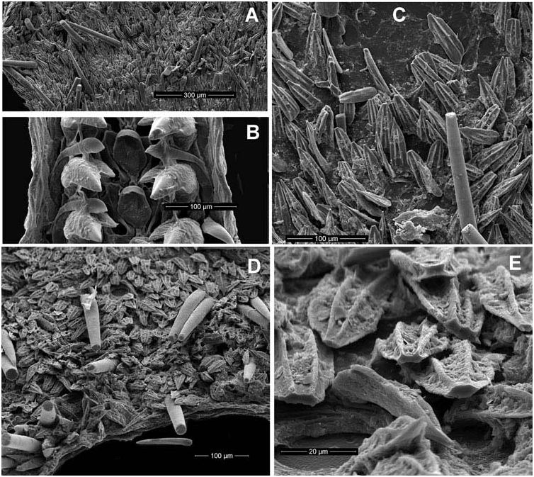
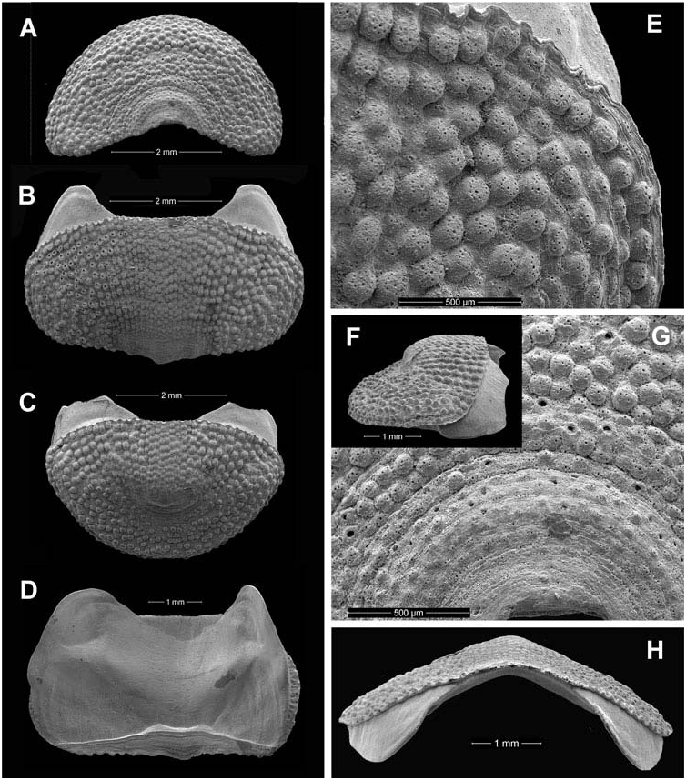
( Figures 9–19 View Figure 9 View Figure 10 View Figure 11 View Figure 12 View Figure 13 View Figure 14 View Figure 15 View Figure 16 View Figure 17 View Figure 18 View Figure 19 )
Chiton nagelfar Lovén, 1846: 158 View in CoL .
Hanleya nagelfar Kaas and Van Belle 1985: 196 View in CoL , Figure 92, map 19 (synonymy); Waren and Klitgaard 1991: 51, Figures 1–6 View Figure 1 View Figure 2 View Figure 3 View Figure 4 View Figure 5 View Figure 6 ; Dell’ Angelo et al. 1998: 244, PL 1, Figure 10 View Figure 10 .
Type material
Lectotype, NHRM, type collection 1329 (designated by Kaas and Van Belle (1985)).
Type locality
Finnmark, Norway.
Material examined
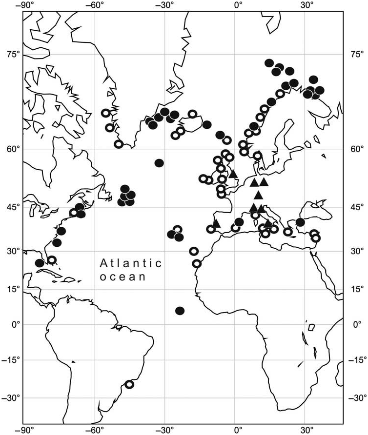
Barents and Norwegian Seas: R/V Andrey Pervozvaniy, 1899, stn 4, 70.0230° N, 31.49° E, 144–178 m, 2 spms; stn 38, 69.58° N, 32.40° E, 230 m, 1 spm; 1900, stn 102, 74.27° N, 22.04° E, 180–211 m, 1 spm ( Table 2 View Table 2 , No. 8); stn 462, 71.20° N, 33.30° E, 304– 280 m, 1 spm; stn 464, 71.21° N, 3159° E, 268 m, 1 spm. R/V Persey, 1924, stn 228, 70.3030° N, 31.13° E, 175 m, 1 spm ( Table 2 View Table 2 , No. 10); 1927, stn 677, 69.31° N, 34.39° E, 173 m, 1 spm; 1935, stn 3337, 71.35° N, 31.464° E, 313 m, 1 spm ( Table 2 View Table 2 , No. 11).
R/V SRT4225, cruise 1, 1955, stn 38/104, 61.308° N, 04.166° E, 300 m, 1 spm. R/ V Sevastopol. GoogleMaps RT-97, cruise 8, 1958, Lofoten Ids., 68.08° N, 13.50° E, 1 spm ( Table 2 View Table 2 , No. 7); GoogleMaps cruise 9, 1958, stn 1453, 62.002° N, 6.146° W, 112 m, GoogleMaps 1 spm; stn 1488, 72.291° N, 23.072° E, 335 m, GoogleMaps 2 spms. R/ V Maslov, cruise 5, 1969, stn 180/201, 70.40° N, 17.275° E, 510 m, GoogleMaps 1 spm; stn 182/203, 71.30° N, 16.46° E, 300 m, GoogleMaps 1 spm ( Table 2 View Table 2 , No. 13); stn 183/204, 72.02° N; 17.02° E, 360 m, GoogleMaps 1 spm ( Table 2 View Table 2 No. 12); stn 188/209, 73.20° N, 15.25° E, 500 m, GoogleMaps 1 spm. R/ V Tunets, cruise 105, 1978, stn 4, 70.06° N, 32.325° E, 230 m, GoogleMaps 1 spm; stn 11, 70.110° N, 17.350° E, 225 m, GoogleMaps 2 spms; stn 12, 70.330° N, 16.540° E, 1100 m, GoogleMaps 5 spms. R/ V Dalnie Zelentsi, cruise, 16.1982, stn 64, 67.559° N, 10.080° E, 280 m, 3 spms. F.D. Behrens, 1948, Lofoten, GoogleMaps 2 spm ( ZIM). F.D. Saturn, 1958, 64.44° N, 35.06° W, 500 m, 1 spm. ( ZIM) GoogleMaps ; 1923, Folden, 50–100 m, 1 spm, ( TM 13350 ) ; Skattora, Tromso, 54 m, 2 spms, ( Table 2 View Table 2 , No. 5), ( TM 12923 ) ; 1951, Senja, Steinavar, 360–365 m, 1 spm, ( TM 13335 ) ; 1954, Morsdalsfjord, 50–110 m, 1 spm, ( TM 13196 ) ; 1954, Balsnes, 28 m, 1 spm, ( TM 13258 ) ; 1954, Brokskar, Rystr, 50–120 m, 1 spm ( Table 2 View Table 2 , No. 3), ( TM 12962 ) ; Beiarn, 40–90 m, 1 spm, ( TM 13237 ) ; 1955, Tjelsund, 60–110 m, 1 spm, ( TM 12955 ) ; 1955, Holandsfjord, 45–770 m, 1 spm, ( TM 13241 ) ; 1955, Eiet, 52–58 m, 6 spms, ( TM 13001 ) ; Masoy, 125– 90 m, 2 spms, ( TM 13299 ) ; 1955, Bjarandfjord, 76–92 m 1 spm, ( TM 12997 ) ; 1955, Rana, 35–42 m, 1 spm, ( TM 13304 ) .
Eastern Greenland Sea: R/ V Atlantida, cruise 10, 1973, stn 18/1668, 74.50° N, 16.00° E, 360 m, 1 spm GoogleMaps .
Southeastern Greenland: R/ V Sevastopol, RT-97, cruise 5, 1957, stn 1168, 66.162° N, 31.356° W, 345 m, GoogleMaps 2 spms; stn 1609, 65.526° N, 29.586° W, 425 m, 1 spm GoogleMaps .
Central and North Atlantic Ocean: R/ V Akademik Keldysh, cruise 4, 1982 stn 513, 34.261° N, 30.030° W, 690 m, GoogleMaps 1 spm; stn 444, 58.208° N, 31.363° W, 1635– 1535 m, 1 spm; stn 364, Reykjanes Ridge, 1330 m, GoogleMaps 1 spm; st. 385, Reykjanes Ridge, 1680– 1800 m, 1 intermediate valve; R/ V Ichtiandr cruise 8, 1982, stn 39, 09.038° N, 21.101° W, 610–700 m, GoogleMaps 1 spm; stn 50, 33.141° N, 29.425° W, 700–740 m, 1 spm GoogleMaps .
Newfoundland Bank: R/V Sevastopol, RT-97, cruise 16, 1960, stn 2805, 49.477° N, 50.185° W, 318–324 m, 1spm; R/V Nereida, 2009 , cruise 0509, stn 6, cod 5, 48.2915° N, 44.0609° W, 1348 m, 1 spm; stn 10, cod 54, 48.0005° N, 43.7607° W, 1554 m, 1 spm; stn 12, cod 16, 47.7772° N, 43.5748° W, 1462 m, 1 spm; stn 19, cod 21, 47.1643° N, 43.5338° W, 1358 m, 2 spms ( Table 2 View Table 2 , No. 4), stn 22, cod 12, 46.8400° N, 43.6404° W, 956 m, 1 spm ( Table 2 View Table 2 , No. 6); stn 23, cod 22, 46.7749° N, 43.8651° W, 1127 m, 3 spms; stn 24, cod 27, 46.6942° N, 43.9686° W, 1104 m, 1 spm; 2010, cruise 0610, stn 63, cod 8, 46.3697° N, 44.9944° W, 1406 m, 2 spms; stn 67, cod 7, 46.2677° N, 46.5429° W, 613 m, 1 spm; stn 69, cod 10a, 46.1543° N, 46.4503° W, 502 m, 1 spm; stn 69, cod 10c, 46.1543° N, 46.4503° W, 502 m, 2 spms; stn 71, cod 10, 46.0800° N, 46.3421° W, 888 m, 1 spm; cruise 0710, stn 75, cod. 24, 45.8692° N, 46.8210° W, 1227 m, 1 spm ( Table 2 View Table 2 , No. 1); stn 96, cod. 30, 43.9894° N, 48.9512° W, 863 m, 1 spm; cruise 0810, stn 99, cod 11, 43.6147° N, 49.0781° W, 548 m, 1 spm; stn 100, cod 12, 43.4844° N, 49.1855° W, 694 m, 2 spm; stn 103, cod 20, 429433° N, 49.5621° W, 1154 m, 1 spm. FN3L, 2006, stn 2, 47.9415° N, 47.3725° W, 411 m, 1 spm; FN3L, 2006, stn 9, 47.9370° N, 47.1883° W, 460 m, 1 spm; FN3L, 2008, stn 37, 47.6480° N, 47.1340° W, 503 m, 2 spms; FN3L, 2008, stn 84, 46.4488° N, 47.2603° W, 396 m, 1 spm; FN3L, 2009, stn 89, 461100° N, 47.3333° W, 1005 m, 2 spms; PLA, 2008, stn 98, 43.6298° N, 48.9907° W, 1436 m, 4 spms ( Table 2 View Table 2 , No. 9).
North America: Off Eastport, Maine (Jeffreys coll.), 1 spm, ( USNM, 177511); Off Martha’ s Vineyard, Massachussetts, 1 spm, ( USNM); Georges Bank, 270 m, 1 spm ( USNM); Nova Scotia, 72 m, 1 spm ( USNM).
Distribution
North and Central Atlantic Ocean , the Barents , Norwegian and Greenland seas, near southern Greenland, North America , Europe and northern Africa, on Mid-Atlantic Ridge from 74.27° N to 09.038° N at depths from 28 to 1680 m , mostly deeper than 200 m.
Large specimens of Hanleya nagelfar are easily distinguished from H. hanleyi (see Kaas and Van Belle, 1985), but small chitons (<10 mm) are difficult to identify.
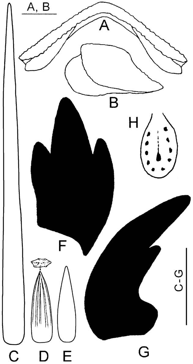
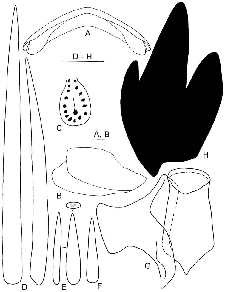
In order to study age variability in H. nagelfar , seventeen specimens of different sizes (BL = 5.0–73.0 mm), from different regions of the Atlantic Ocean were measured ( Table 2 View Table 2 , Figures 8–18 View Figure 8 View Figure 9 View Figure 10 View Figure 11 View Figure 12 View Figure 13 View Figure 14 View Figure 15 View Figure 16 View Figure 17 View Figure 18 ). These measurements revealed that important changes occur in the shape of the valves, the thickness of the girdle, and the shape, size and ribbing of the dorsal spicules of the girdle.
With increasing body length, the ratio of head valve width/tail valve width decreased from 1.27 (BL = 5.0 mm) to 0.84 (BL = 70.0 mm); the ratio of valve V width/valve V length decreased from 2.56 (BL = 5.0 mm) to 1.36 (BL = 70.0 mm); and the ratio of valve V width/width of adjacent girdle also decreased from 5.9 (BL = 5.0 mm) to 1.36 (BL = 70.0 mm) ( Table 2 View Table 2 ).
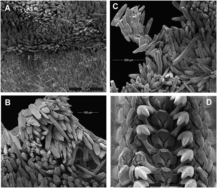
Small and medium size specimens (BL = 5.0–29.0 mm) have flattened, short and pointed spicules with 6–7 ribs arranged around the spicule ( Figures 10A, C View Figure 10 , 12A, B View Figure 12 , 14A, C, D, E View Figure 14 , 16A–C View Figure 16 , 17D View Figure 17 , 18A, C View Figure 18 ). With increasing age (specimen size) the spicules become longer and the ribs become less prominent or obsolete ( Figures 18B, D View Figure 18 , 19E View Figure 19 ).


No known copyright restrictions apply. See Agosti, D., Egloff, W., 2009. Taxonomic information exchange and copyright: the Plazi approach. BMC Research Notes 2009, 2:53 for further explanation.
|
Kingdom |
|
|
Phylum |
|
|
Class |
|
|
Order |
|
|
Family |
|
|
Genus |
Hanleya nagelfar ( Lovén, 1846 )
| Sirenko, Boris 2014 |
Hanleya nagelfar
| Angelo B & Lombardi C & Taviani M 1998: 244 |
| Waren A & Klitgaard A 1991: 51 |
| Kaas P & Van Belle RA 1985: 196 |
Chiton nagelfar Lovén, 1846: 158
| Loven SL 1846: 158 |