
Tetramorium sericeiventre Emery, 1877
|
publication ID |
https://doi.org/ 10.1080/00222933.2021.1899325 |
|
persistent identifier |
https://treatment.plazi.org/id/3A0487AD-7E7C-FA6C-FE4A-FC10FB9D9BD1 |
|
treatment provided by |
Plazi |
|
scientific name |
Tetramorium sericeiventre Emery, 1877 |
| status |
|
Tetramorium sericeiventre Emery, 1877 View in CoL
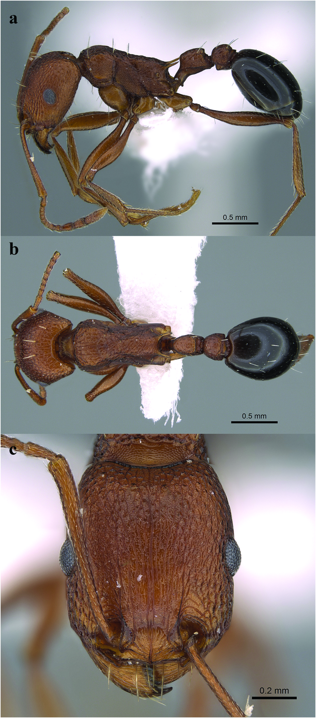
( Figures 1–2 View Figure 1 View Figure 2 )
Tetramorium sericeiventre Emery, 1877: 370 View in CoL View Cited Treatment (w.) Eritrea. Afrotropic. For full synonymic history see Hita Garcia and Fisher (2011).
Identification. Tetramorium sericeiventre View in CoL can be diagnosed by the following characters: frontal carinae short and feebly developed; metanotal groove absent; propodeal spines sharp; propodeal lobes long, usually of same length of propodeal spines; petiolar nodes rectangular, in profile with a feebly convex dorsum; cephalic surface, mesosoma (except propodeum), petiole, postpetiole, and gaster with sparse and stout standing hairs. Among Arabian Tetramorium species , T. sericeiventre View in CoL can be confused with T. khyarum Bolton, 1980 View in CoL from Nigeria in all morphological characters except the lack of the single pair of hairs on the propodeal dorsum.
Worker morphology. Head. Head distinctly longer than broad; anterior clypeal margin entire and convex; frontal carinae short and feebly developed; antennal scrobes absent; scapes when laid back from their insertions relatively long, surpassing posterior head margin; eyes small to moderate with 11 to 14 ommatidia in longest row. Mesosoma. Mesosomal profile flat; metanotal groove absent; propodeal spines sharp and narrow; propodeal lobes relatively long, usually of same length of propodeal spines. Petiole. Petiolar nodes rectangular, in profile with a feebly convex dorsum. Postpetiole. Postpetiole in profile rounded, distinctly higher than long, in dorsal view clearly broader than long, and broader than petiolar node. Sculpture. Mandibles longitudinally striate or rugose; clypeus with a median longitudinal ruga; cephalic sculpture variable, usually reticulate-rugose; mesosomal, petiolar, and postpetiolar sculpture variable, usually with longitudinal rugae and with a reticulate-punctulate ground sculpture; first gastral tergite usually densely punctulate or strongly shagreened. Pilosity. Cephalic surface, mesosoma (except propodeum), petiole, postpetiole, and gaster with sparse and stout standing hairs, pronotum and mesonotum with 5 to 6 pairs of hairs, propodeum bare; scapes and tibiae with short and appressed pubescence. Colour. Colour red-brown to brown, sometimes dark brown, gaster often darker than rest of body.
Material examined. We examined a total 431 Tetramorium sericeiventre specimens (specimens deposited in KSMA unless otherwise noted). KSA: Al-Baha Province: Al- Baha, Shada Mountain , 19.8388°N, 41.3117°E, 1620 m, 22 GoogleMaps .ix GoogleMaps .2011, M. R. Sharaf, 6 w; Baljurashi, Al Qam’a park, 19.48°N, 41.43°E, 1950 m, 21 GoogleMaps .ix GoogleMaps .2011, M. R. Sharaf, 9 w; Baljurashi, Al Qam’a park, 19.48°N, 41.43°E, 1931 m, 17 GoogleMaps .v GoogleMaps .2010, M. R. Sharaf, 35 w, 3 q; Al Mukhwah, Dhi Ayn Archaeological vill ., 19.9295°N, 41.4428°E, 744 m, 20 .ix .2011, M. R. Sharaf, MRS0022, 1 w; Al-Baha, Al Mukhwah, Dhi Ayn Archaeological vill ., 19.9295°N, 41.4428°E, 744 m, 08 .xi .2012, M. R. Sharaf, MRS0106, 2 w; Al Mukhwah, Dhi Ayn Archaeological vill ., 19.9295°N, 41.4428°E, 744 m, 17 .iv .2013, M. R. Sharaf, MRS0152, 9 w; Al Mukhwah, Dhi Ayn Archaeological vill ., 19.9295°N, 41.4428°E, 741 m, 18 .v .2010, M. R. Sharaf, 23 w, 1 q; Al Mukhwah, Dhi Ayn Archaeological vill ., 19.9295°N, 41.4428°E, 744 m, 07 .iv .2013, M. R. Sharaf, MRS0152, 8 w; Al Mukhwah, Dhi Ayn Archaeological vill ., 19.9295°N, 41.4428°E, 741 m, 11 .v .2011, M. R. Sharaf, 17 w; Al Mukhwah, Dhi Ayn Archaeological vill ., 19.9295°N, 41.4428°E, 741 m, 15 .v .2011, M. R. Sharaf, 6 w; wadi Wlzaraeb ( Kheir ), 20.0600°N, 41.3865°E, 2123 m, 15 GoogleMaps .v GoogleMaps .2010, M. R. Sharaf, 2 w, 3q, 2 m; wadi Moqwah , 19.4950°N, 41.2267°E, 482 m, 07 GoogleMaps .iii GoogleMaps .2013, M. R. Sharaf, 1 w; Shohba forest , 20.0453°N, 41.4760°E, 2324 m, 14 GoogleMaps .v GoogleMaps .2010, M. R. Sharaf, 3 w; Shohba forest , 20.0453°N, 41.4760°E, 2324 m, 14 GoogleMaps .v GoogleMaps .2010, M. R. Sharaf, 6 w; Amadan, El Mandaq , 20.2027°N, 41.2317°E, 1881 m, 19 GoogleMaps .v GoogleMaps .2010, M. R. Sharaf, 2 w; wadi Turabah , 20.2110°N, 41.2882°E, 1793 m, 10 GoogleMaps . v GoogleMaps .2011, M. R. Sharaf, MRS0011, 12 w; Asir Province: Khamis Mushayt, wadi Bishah , 18.3336 °N, 42.7035°E, 1990 m, 27 GoogleMaps .iv GoogleMaps .2011, M. R. Sharaf, 7 w; Khamis Mushayt, wadi Ben Hashbal , 18.5948°N, 42.6503°E, 1892 m, 26 GoogleMaps .iv GoogleMaps .2011, M. R. Sharaf, 4 w; Dalaghan , 18.1014 °N, 42.7051° E, 17 GoogleMaps .iv GoogleMaps .2008, M. R. Sharaf, 2 w, 1q; AlUrdyiah Gov ., wadi Gonouna , 19.4293°N, 41.6050°E, 353 m, 12 GoogleMaps .v GoogleMaps .2011, M. R. Sharaf, MRS3.4, 5 w; Al Atawla (Al-Baha-Taif RD), wadi Bawah , 20.7496°N, 41.2474°E, 1310 m, 08 GoogleMaps .xi GoogleMaps .2012, M. R. Sharaf, MRS0108, 1 w; Riyadh Province: Rawdhat Khorim , 25.23°N, 47.17°E, 559 m, 18 GoogleMaps .iii GoogleMaps .2012, M. R. Sharaf, CASENT 0906430,1 w; Rawdhat Khorim , 25.3861°N, 47.2767°E, 618 m, 02 GoogleMaps .vi GoogleMaps .2013, S. Salman, 9 w; Rawdhat Khorim , 25.3824°N, 47.2797°E, 551 m, 16 GoogleMaps .i GoogleMaps .2015, S. Salman, 3 w; wadi Hanifa , 24.6649°N, 46.6057°E, 633 m, 15 GoogleMaps .i GoogleMaps .2010, M. R. Sharaf, 2 w; wadi Hanifa , 24.7709°N, 46.5314°E, 695 m, 18 GoogleMaps .ix GoogleMaps .2014, S. Salman, 2 w (1 w with a broken gaster); Al-Ammariyah , 24.8183°N, 46.4469°E, 696 m, 12 GoogleMaps .x GoogleMaps .2013, S. Salman, 6 w; W. Eldawaser , 20.4865°N, 44.7643°E, 690 m, 22 GoogleMaps .i GoogleMaps .2014, S. Salman, 1 w; Mezahmyia , 24.4838°N, 46.2631°E, 648 m, 25 GoogleMaps .i GoogleMaps .2014, S. Salman, 1 w; Buaythiran , 25.1486°N, 45.9503°E, 815 m, 07 GoogleMaps .ii GoogleMaps .2011, M. R. Sharaf,1 w; AlHayer , 24.5537° N, 46.7380°E, 648 m, 11 GoogleMaps .iv GoogleMaps .2014, S. Salman, 7 w; AlHayer , 24.5570°N, 46.4355°E, 589 m, 11 GoogleMaps . iv GoogleMaps .2014, S. Salman, 4 w (1 w with a broken gaster); Rumah , 25.5706°N, 46.9725°E, 615 m, 11 GoogleMaps . iv GoogleMaps .2014, S. Salman, 2 w; Dirab , 24.4186°N, 46.6540°E, 604 m, 18 GoogleMaps .ix GoogleMaps .2014, S. Salman, 1 w; Dirab , 24.4186° N, 46.6540° E, 588 m, 30 GoogleMaps .xii GoogleMaps .2009, M. R. Sharaf, 3 w; Oyaina , 24.9066° N, 46.3899° E, 749 m, 28 GoogleMaps .iv GoogleMaps .2010, M. R. Sharaf, 5 w, 8q; Majmaa , 26.0049°N, 45.0189° E, 594 m, 13 GoogleMaps .ix GoogleMaps .2014, S. Salman, 5 w; Majmaa , 25.9223°N, 45.31045° E, 736 m, 13 GoogleMaps .ix GoogleMaps .2014, S. Salman, 3 w; Ghiyanah , 25.0736°N, 46.2264°E, 793 m, 26 GoogleMaps .xii GoogleMaps .2014, S. Salman, 15 w; Dawadimi , 24.5375°N, 44.3548°E, 999 m, 16 GoogleMaps .i GoogleMaps .2015, S. Salman, 5 w; Dawadimi , 24.5521°N, 43.9317°E, 873 m, 16 GoogleMaps .i GoogleMaps .2015, S. Salman, 31 w; Dawadimi , 24.4840°N, 44.3767°E, 893 m, 18 GoogleMaps .iv GoogleMaps .2014, S. Salman, 1 w; Dawadimi , 24.4670°N, 44.3424°E, 1038 m, 18 GoogleMaps .iv GoogleMaps .2014, S. Salman, 1 w; Dawadimi , 24.5375°N, 44.3548°E, 999 m, 16 GoogleMaps .i GoogleMaps .2015, S. Salman, 4 w, 2 m; Thadiq , 25.2936° N, 45.8710° E, 735 m, 26 GoogleMaps .iv GoogleMaps .2014, S. Salman, 2 w; Shaqra , 25.3263°N, 45.2334° E, 710 m, 30 GoogleMaps . v GoogleMaps .2014, S. Salman, 4 w; Shaqra , 25.2301°N, 45.3191° E, 703 m, 24 GoogleMaps .i GoogleMaps .2015, S. Salman, 4 w; Quwayaiyah , 24.0504°N, 45.2579°E, 839 m, 29 GoogleMaps .xi GoogleMaps .2014, S. Salman, 1 w; Hawtat Bani Tamim , 23.5073°N, 46.9005°E, 593 m, 13 GoogleMaps .xii GoogleMaps .2014, S. Salman, 5 w; Hawtat Sudair , 25.5916°N, 45.6124°E, 732 m, 31 GoogleMaps .i GoogleMaps .2015, S. Salman, 9 w; Afif , 23.9000°N, 42.8807°E, 1052 m, 17 GoogleMaps . i GoogleMaps .2015, S. Salman, 2 w; Sajir , 25.0650°N, 44.6974°E, 751 m, 23 GoogleMaps .i GoogleMaps .2015, S. Salman, 1 w; Sulayel , 22.2028°N, 46.6943°E, 560 m, 19 GoogleMaps .ii GoogleMaps .2015, S. Salman, 6 w; Kharrarah , 24.3916°N, 46.2443°E, 726 m, 08 GoogleMaps .iv GoogleMaps .2015, S. Salman, 5 w; Ghiyanah , 25.0736°N, 46.2264°E, 728 m, 26 GoogleMaps . xii GoogleMaps .2014, S. Salman, 3 w; Ghiyanah , 25.0736°N, 46.2264°E, 793 m, 26 GoogleMaps .xii GoogleMaps .2014, S. Salman, 3 w; Bijadriyah , 24.3101°N, 43.7313°E, 934 m, 16 GoogleMaps .i GoogleMaps .2015, S. Salman, 3 w; Salboukh , 25.0792°N, 46.3472°E, 05 GoogleMaps .xi GoogleMaps .2009, M. R. Sharaf,18 w; Salboukh , 25.0783°N, 46.3469°E, 716 m, 26 GoogleMaps . xii GoogleMaps .2017, M. R. Sharaf,1 w; wadi Huraymila , 25.0686°N, 46.0027°E, 15 GoogleMaps .ix GoogleMaps .2011, F. A. Esteves, FAE912, CASENT0264322, 1 w; Huraymila , 25.1206°N, 46.1159°E, 15 GoogleMaps .ix GoogleMaps .2011, F. A. Esteves, FAE911, CASENT0263997, 1 w ( KSMA); wadi Drady , 01 .v .1980, W. Buttiker, 1 w; Jizan, 2 w ( WMLC); Alkarj , 24.1576°N, 47.3248°E, 25 GoogleMaps .v GoogleMaps .1980, W. Buttiker, 2 m, ( WMLC); Abu Arish , 16.9692°N, 42.8443°E, 27 GoogleMaps .iii GoogleMaps .1983, C. A. Collingwood, 1 m, ( WMLC); wadi Qust (Mecca region), 21.0436°N, 41.2886°E, 07 GoogleMaps .iv GoogleMaps .1983, C. A. Collingwood, 1 w, ( WMLC); Al Khubra , 26.2172°N, 50.1971°E, 29 GoogleMaps .v GoogleMaps .1978, W. Buttiker, 1 m, ( WMLC); Fayfa , 17.2473°N, 43.1069°E, 27–31 GoogleMaps .iii GoogleMaps .1983, Holzschuh, 1 w, ( WMLC); wadi Tumair (Riyadh Province), 23.8667°N, 46.9833°E, 20 GoogleMaps .ii GoogleMaps .1976, Buttiker, 1 w, ( WMLC); wadi Azizah , 18.217°N, 42.433°E, 17–18 GoogleMaps . ix GoogleMaps .1983, C. A. Collingwood, 4 w, ( WMLC); wadi Maraba , 17.9°N, 42.3833°E, 16 GoogleMaps .x GoogleMaps .1979, Buttiker, 1 w, ( WMLC); OMAN: Khawr Sawli (Dhofar), 17.0329°N, 54.3298°E, 08 GoogleMaps .i GoogleMaps .1985, Gallager, 5 w; Hajar Mnt ., Salma Plateau , 22.8777°N, 59.1186°E, 1334 m, 14 GoogleMaps .xi GoogleMaps .2018, A. Polaszek, 2 w; Dhofar, Ayn Sahlanot , 17.14766°N, 54.17878°E, 151 m, 16 GoogleMaps .xi GoogleMaps .2017, M. R. Sharaf, 2 w, (1 w, CASC, CASENT0922884 ); Ayn Ashat , 16.9981°N, 53.8195°E, 202 m, 21 GoogleMaps .xi GoogleMaps .2017, M. R. Sharaf, 9 w; Ayn Dirbat , 17.1057°N, 54.4529°E, 207 m, 17 GoogleMaps .xi GoogleMaps .2017, M. R. Sharaf , 1 w, ( KSMA); YEMEN: San’a, 15.3694°N, 44.191°E, iii GoogleMaps .1991, Van Harten, 1q, ( WMLC); BENIN: Korobourou , 09°22 ʹ 13 ʹ ’N, 02°40 ʹ 16 ʹ ’E, 14 .ix .2012, J-F Vayssieres, RVA 2895, 2 w; Korobourou, 09°22 ʹ 13 ʹ ’N, 02°40 ʹ 16 ʹ ’E, 9 .xi .2012, J-F Vayssieres, VA 3020.1, 2 w; Koro, 09°22 ʹ 21 ʹ ’N, 02°40 ʹ 13 ʹ ’E, 27 .iii .2013, J-F Vayssieres, RVA 3056.5, 2 w; Kika-Beterou, 09° 14 ʹ 07 ʹ ’N, 02°11 ʹ 52 ʹ ’E, 9 .xi .2011 GoogleMaps , J-F Vayssieres, RVA 3099.12, 3 w; Agonlin, 07°12 ʹ 55.2 ʹ ’N, 02°19 ʹ 13.7 ʹ ’E, 55 m, J-F Vayssieres GoogleMaps , RVA 3108.3, 1 w; CAMEROUN: Poli GoogleMaps , 8°29 ʹ N, 13°15 ʹ E, 15 . vi GoogleMaps .2001 GoogleMaps , G Debout & A Dalecky GoogleMaps , 126, 1 w; Awae II, 03°54 ʹ 30”N, 11°25 ʹ 58”E, 17 .xii GoogleMaps .2006 GoogleMaps , A Fotso Kuate, 1 w; CENTRAL AFRICAN REPUBLIC: Dzanga-Sangha GoogleMaps , 03°55 ʹ 13.2”N, 16° 36 ʹ 46.1”E, 536 m, 20 .i GoogleMaps .2005 GoogleMaps , P Annoyer, Di- 09, 1 w; CONGO: Brazzaville GoogleMaps , 4° 15 ʹ 33”S, 15° 17 ʹ 5”E, 19 .viii GoogleMaps . 2007 GoogleMaps , 317 m, Y Braet, t-1- 1, 2 w; same data as previous material, t-1- 10, 1 w; same data as previous material, t-1- 19, 1 w; Iboubikro, 25 .i GoogleMaps .2008 GoogleMaps , Y Braet & E Zassi, 1 w; GABON: Pongara GoogleMaps , 00°34 ʹ N, 09°19 ʹ E, 16 .vii GoogleMaps .2006 GoogleMaps , L Volait, G 17, 2 w; same data as previous material, G 18, 1 w; same data as previous material, G 19, 1 w; GHANA: no locality, 2005, S Sky Stephens, 05G0011, 1 w; NAMIBIA: Caprivi Park GoogleMaps , 17°46 ʹ 56”S, 23°16 ʹ 31”E, 15 .xii GoogleMaps .1999 GoogleMaps , Mann & Marais, OUMNH-2006- 093, 6 w; SENEGAL: Tambacounda, Dindifa GoogleMaps , 13°09 ʹ 40”N, 12° 06 ʹ 46”W, 213 m, 10 .v GoogleMaps .2009 GoogleMaps , B Ndiaye, 3 w; Ferlo, Katané GoogleMaps , 15.48°N, 14.08°W, x .2010 GoogleMaps , B Ndiaye, 4 w; Lamine Diamé, Sébikotane GoogleMaps , 14°46 ʹ N, 17°07 ʹ W, 2012, 3 w; SUDAN: Jabel GoogleMaps awlya, 15°14 ʹ 28”N, 32°29 ʹ 59”E, 2009, A Omer, 1 w; Wad Al Hadad GoogleMaps , 13°49 ʹ 28.14”N, 33° 32 ʹ 39.33”E, 9 .ii GoogleMaps .2010 GoogleMaps , Z Mahmoud, 2009– 77, 1 w; South Sudan GoogleMaps , 8.183°N, 30.317°E, vi. 2005, A Omer, S 1–14- 1, 1 w; Dinder NP, 11°N, 35°E, 2012, A Omer, 26, 1 w; Sinja, 13° 09 ʹ N, 33°55 ʹ 60”E, 17 . Ii GoogleMaps .2013 GoogleMaps , A Omer, 2 w; Abu Hijar GoogleMaps , 12°52 ʹ N, 34°0 ʹ E, 24 .ii GoogleMaps .2013 GoogleMaps , A Omer, 1 q; Abu Hijar GoogleMaps , 12°52 ʹ N, 34°0 ʹ E, 28 .ii GoogleMaps .2013 , A Omer, 3 w ( OUMC).
Morphological variation. Tetramorium sericeiventre displays a wide range of colour variation ranging from distinctly contrasting body colour with head, mesosoma, petiole and postpetiole clear yellow, light brown or dark brown and gaster frequently dark black brown to black ( Figures 1–2 View Figure 1 View Figure 2 ). In rare cases, workers have bark brown to black brown body with head conspicuously paler usually reddish to brown. Its body sculpture also shows a remarkable degree of variation, comprehensively discussed by Bolton (1980) and Hita Garcia and Fisher (2011). Some workers are uniform black with superficial sculpture on the head, mesosoma, petiole and postpetiole, while some workers are relatively smooth and shiny. Bolton (1980) presented 25 synonyms for T. sericeiventre , 13 of which were from a single reference ( Santschi 1918). Hita Garcia and Fisher (2011) added eight additional synonyms from the Malagasy fauna. This high number of synonyms is the result of the wide range of variation within the species.
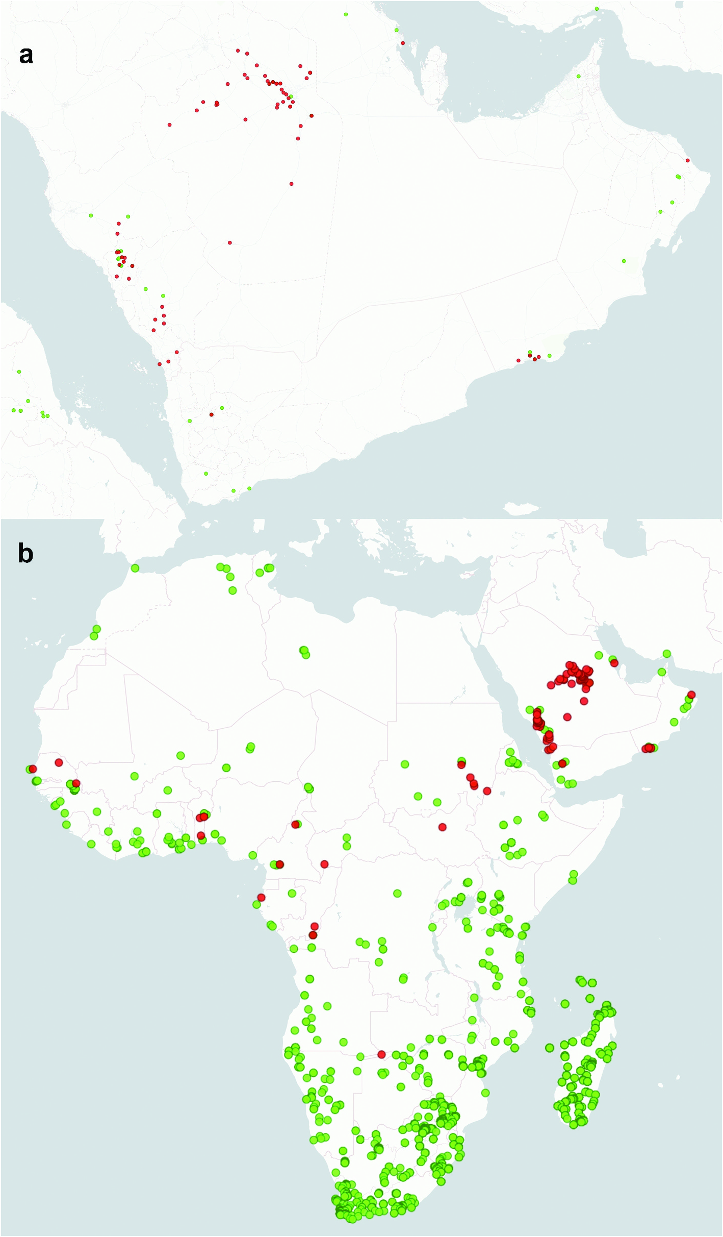
Natural History in KSA. Tetramorium sericeiventre occurs in a wide range of habitats in KSA (e.g. see Figure 3 View Figure 3 ). In the woodland forests of the Asir Mountains, this species builds nests in ground under rocks and stones near Acacia (Fabaceae) and Juniper ( Cupressaceae ) trees. We observed workers foraging in humid leaf litter in the Al Sarawat Mountains and coexisting with some beetle species of the families Pselaphinae , Staphylinidae and Tenebrionidae . In the Fayfa Mountains, T. sericeiventre foraging at night and attracted to tight traps. Males are frequently attracted to light ( Collingwood 1985).
In the KSA, T. sericeiventre was found at numerous mid and high elevation (572–2387 m) sites ( Table 1). It was the most abundant Tetramorium collected by pitfall traps in Acacia thorn woodlands and in areas of cactus pear, Opuntia ficus-indica (L.) Mill. ( Cactaceae ) and wild olive trees Olea europaea ssp cuspidata (Wall.ex G. Don) Cifferi ( Oleaceae ) in the mountainous areas of southwest of the KSA. The species is also the commonest Tetramorium in sandy areas of Riyadh Province, with Acacia ehrenbergiana Heyne (Fabaceae) , Echinops sp. (Compositae) , Pulicaria undulata (L.) C. A. Mey. ( Asteraceae ), and Artemisia graveolens Rydb. (Asteraceae) .
In wadi Hanifa, Riyadh,we found T. sericeiventre more abundant in the rural and suburban areas than in urban areas. At Rawdhat Khorim, Sharaf et al. (2013) found a similarly high abundance of T. sericeiventre . In Al-Baha Province, El-Hawagry et al. (2013) collected T. sericeiventre in five different natural areas in the Al Sarawat Mountains: Amadan forest, Baljurashi, Raghdan forest, Shahba forest, and wadi El-Zarayeb.
Geographic distribution. Tetramorium sericeiventre is broadly spread throughout open habitats of the Arabian Peninsula, the Afrotropical ( Bolton 1980) and the Malagasy ( Hita Garcia and Fisher 2011) ( Figure 4 View Figure 4 ). On the Arabian Peninsula, it is one of the most widely distributed Tetramorium species ( Collingwood 1985; Collingwood and Agosti 1996; Collingwood et al. 2011; Sharaf et al. 2013).
We did not map three erroneous or questionable published site records of T. sericeiventre . Chapman and Capco (1951) erroneously listed a record of Tetramorium sericeiventre munda Santschi from Guinea, West Africa as from Melanesian island of New Guinea. Collingwood and Agosti (1996) marked in a table that T. sericeiventre occurs in Kuwait, but the paper included no records from Kuwait. De Haro and Collingwood (1994) listed T. sericeiventre as present in southern Iberia, but we found no specimen records supporting this.


No known copyright restrictions apply. See Agosti, D., Egloff, W., 2009. Taxonomic information exchange and copyright: the Plazi approach. BMC Research Notes 2009, 2:53 for further explanation.
|
Kingdom |
|
|
Phylum |
|
|
Class |
|
|
Order |
|
|
Family |
|
|
Genus |
Tetramorium sericeiventre Emery, 1877
| AL-Keridis, Lamya A., Gaber, Nevien M., Aldawood, Abdulrahman S., Wetterer, James K. & Sharaf, Mostafa R. 2021 |