
Acnephalomyia andrenoides ( Wiedemann, 1828 ) Londt, 2010
|
publication ID |
https://doi.org/ 10.5733/afin.051.0212 |
|
publication LSID |
lsid:zoobank.org:pub:ADE55AE3-E55C-46CE-865D-1101B9875869 |
|
persistent identifier |
https://treatment.plazi.org/id/FA455017-FFEC-AD6A-FECA-741A495BFCD2 |
|
treatment provided by |
Felipe |
|
scientific name |
Acnephalomyia andrenoides ( Wiedemann, 1828 ) |
| status |
comb. nov. |
Acnephalomyia andrenoides ( Wiedemann, 1828) View in CoL View at ENA comb. n.
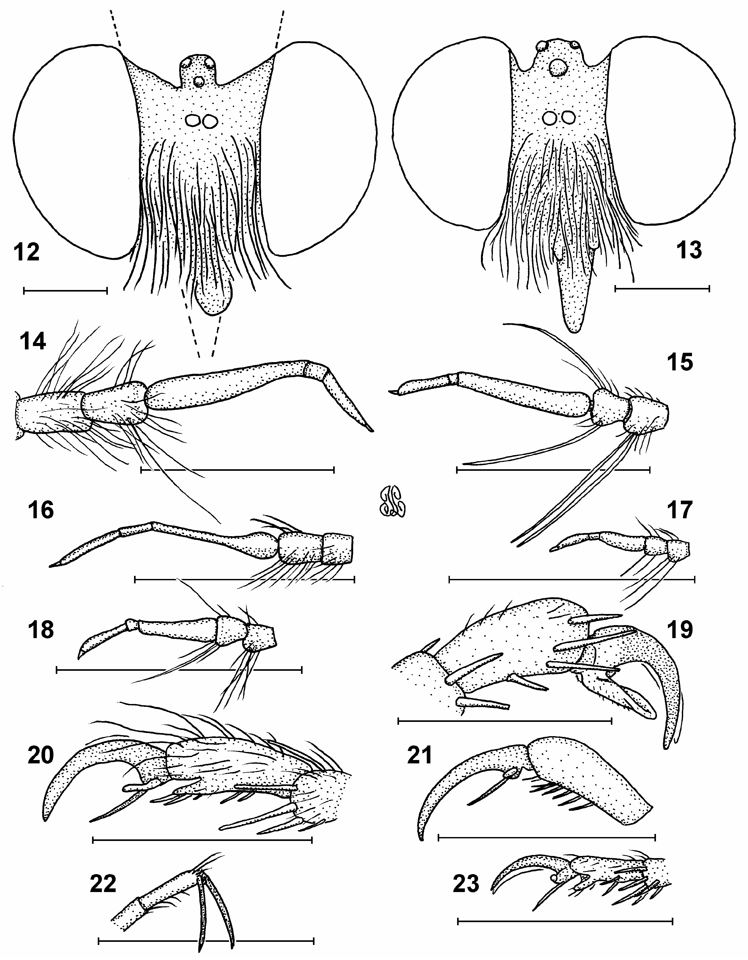
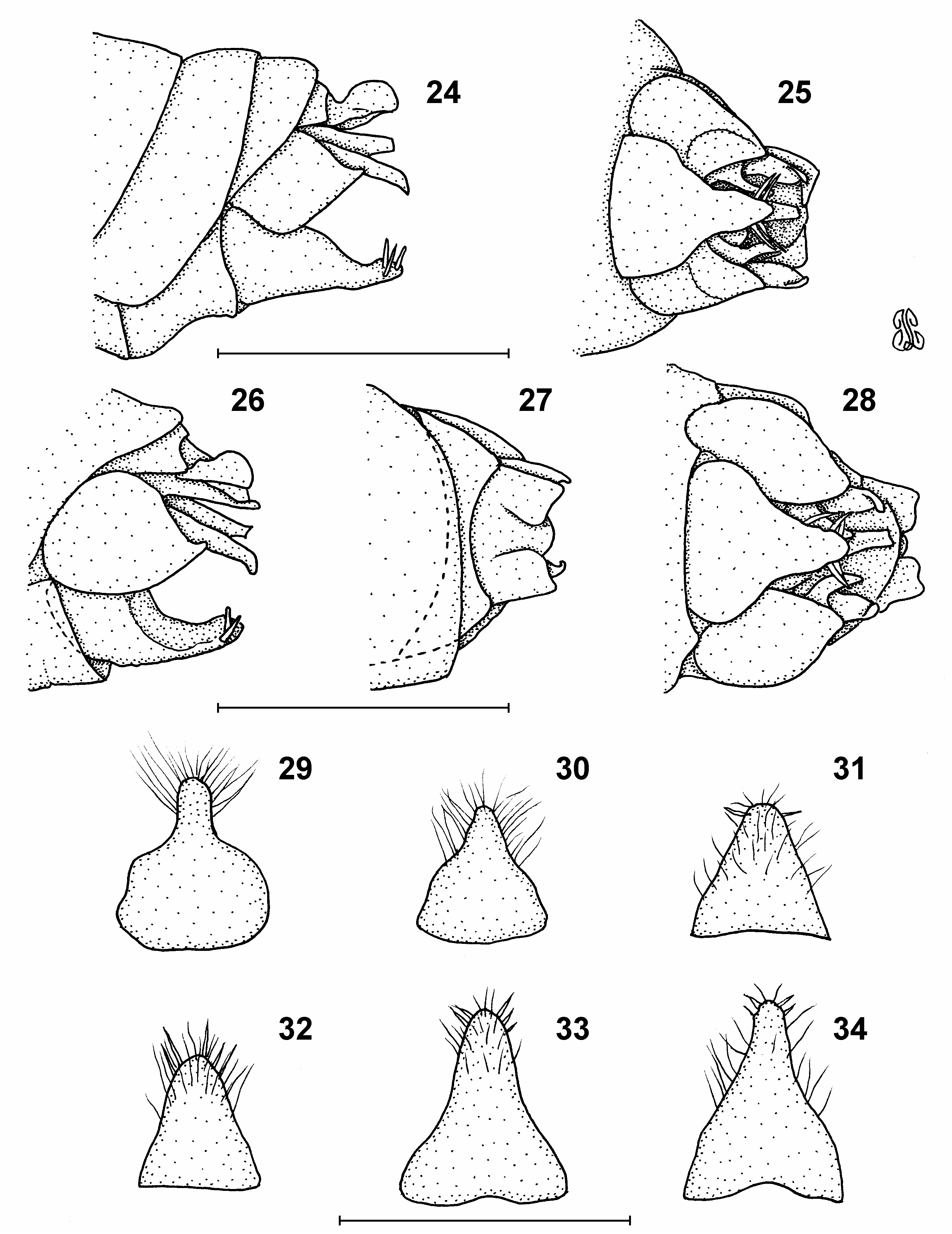
Figs 1 View Figs 1–5 , 7 View Figs 6–11 , 13, 15, 20 View Figs 12–23 , 24–34 View Figs24–34 , 65 View Fig
Dasypogon andrenoides: Wiedemann 1828: 403 View in CoL .
Dasypogon quadratus Wiedemann, 1828: 404 View in CoL . Syn. n.
Acnephalum punctipennis Macquart, 1855: 71 ; Kertesz 1909: 88 (catalogue); Hull 1962: 192. Syn. n.
Acnephalum andrenoides: Hermann 1907: 8 ; Kertesz 1909: 87 (catalogue); Curran 1934: 5–6; Hull 1962:
192, figs 140 (antenna), 524 (wing), 1032, 1044 (head); Oldroyd 1974: 27; 1981: 359 (catalogue).
Acnephalum quadratum: Kertesz 1909: 88 View in CoL (catalogue); Curran 1934: 5–6; Hull 1962: 192, figs 1757–1759
(♂ terminalia); Oldroyd 1974: 27; 1981: 359 (catalogue).
Acnephalum cockerelli Curran, 1934: 5–6 View in CoL ; Hull 1962: 192; Oldroyd 1974: 27; 1981: 359 (catalogue). Syn. n. Sisyrnodytes sericeus Oldroyd, 1974: 72 View in CoL ; 1981: 368. Syn. n.
Acnephalum sericeus: Londt 2009: 171 .
Redescription (Based chiefly on lectotype. Condition: Good; slightly dusty, and has a circular hole in the centre of the mesonotum, probably made by a pin at the time of mounting):
Head ( Fig. 13 View Figs 12–23 ): Dark red-brown to black, white setose, slightly greasy (pruinescence not evident). Antenna ( Fig. 15 View Figs 12–23 ): Uniformly orange-brown. Ratios of antennal segments 1.0:0.8:3.3:0.1:1.4 – scape and pedicel subequal in length, white setose except for pale translucent yellowish macrosetae (ventrally on scape, dorsally and ventrally on pedicel); setae of pedicel as long or longer than postpedicel; postpedicel almost twice as long as scape and pedicel combined; style 2-segmented, tipped with spine, subequal in length to scape and pedicel combined. Face dark redbrown to black, mystax fine white, covering entire face. Frons, vertex and postocular region dark red-brown to black, mostly long white setose (some pale yellowish postocular macrosetae dorsally); angle subtended by eye margins at level of frons/vertex c. 8° (i.e. weakly divergent). Proboscis orange-brown to dark red-brown, white setose, slightly downturned distally. Palpus 2-segmented, white and yellowish setose, second segment terminating in short distal projection.
Thorax: Dark red-brown to black except for orange-brown postpronotal and postalar lobes. Pronotum mostly fine white setose, but with transverse row of long yellowish macrosetae. Mesonotum mostly white setose, but with clumps of dull yellowish setae, mostly anteriorly. Lateral macrosetae poorly developed, rather shorts, pale yellow, mostly hidden among longish general body setae. Pleura largely asetose except for numerous, long, terminally wavy, white katatergals and dorsally situated anepisternals. Katepisternum asetose. Scutellum shiny black apruinose with moderately developed transverse subapical groove. About 16 moderately developed, yellowish apical macrosetae accompanied by slightly shorter, fine white setae; disc asetose. Legs: Mostly brown-orange, but parts of fem dark red-brown dorsally. Major setae erect yellowish, minor setae recumbent white. Ventral parts of tar and terminal end of tib short black setose. Claws black, long (about as long as tarsomere 5); empodia slender yellow, about half length of claws; pulvilli small (about one-third length of claws). Haltere pale yellow, base slightly darker. Wing ( Fig. 7 View Figs 6–11 ): 7.3×3.0 mm. Veins brown-orange, membrane largely lacking microtrichiae (weakly present on cells bc, c, sc, iv, basally on r 1 and along anterior margin of br). Membrane pale brown stained proximally, gradually becoming somewhat translucent distally. Vein C extends around wing margin, terminating at A 1, R 4 with well-developed basal stump-vein, cell m 3 open.
Abdomen: Terga clearly broader than long, mostly dark red-brown to black, but narrowly orange-brown laterally. Orange-brown colour extends along posterior margins of more distally situated terga, progressively increasing in extent (T6 being almost entirely orange-brown). Terga apruinose and entirely pitted by setal sockets. Entire abdomen fringed laterally with long (as long as length of individual terga), whitish setae. White setae extend along distal margins of terga gradually becoming shorter medially. Large areas of terga appear asetose, but are covered with tiny blackish setae. Sterna orange-brown, finely gold pruinose, sparsely long white setose. Terminalia largely withdrawn between T6 and S6 and somewhat obscured by setae. Genitalia (based on the paralectotype male; Figs 24, 25 View Figs24–34 ): Epand reduced (much shorter than goncx), broadly rounded distally (not incised medially to form distinct lobes). Proc somewhat swollen in appearance and jutting out well beyond level achieved by epand (lateral view). Exterior lobe of goncx broadly rounded proximally, tapering to acutely pointed tip distally; interior lobe longish, jutting out to about same level as achieved by hypd, slightly downturned distally. Hypd somewhat truncate basally, tapering to narrowly rounded point distally.
Lectotype: SOUTH AFRICA: ♂ ‘ Capland / Krebs S. ’ [blue], ‘ Type’ [orange], ‘ Zool. Mus. / Berlin’ [cream] ( ZMHB).
Paralectotypes: 1♂ 1♀ similar data as lectotype, but ♀ has additional label ‘484’ ( ZMHB) .
Notes: Wiedemann did not designate a holotype so his specimens are considered syntypes. For taxonomic stability I here designate a lectotype and two paralectotypes. Wiedemann (1828) gave scant information regarding the provenance of his type specimens and merely states ‘Bom Kap’ (probably Von Kap = from Cape). He also indicates that the specimens are in the Berlin Museum and his collection. There are 5♀ specimens labelled as andrenoides types in NHMW which are simply labelled ‘Cap b. sp’. Although much of Wiedemann’s material ended up in NHMW I have no means of knowing whether these were available to Wiedemann and so I prefer to consider them as being without the type status .
Notes on synonymies: The following four species are considered nominal taxa.
Dasypogon quadratus Wiedemann, 1828 View in CoL
Wiedemann’s material ( Fig. 1 View Figs 1–5 ), in good condition, was studied and compared with the andrenoides lectotype. The lectotype is almost identical, and only the slight differences recorded below were noted. There is no doubt that quadratus View in CoL is a synonym of andrenoides (as suspected by Oldroyd in 1974).
Head: Antenna: Segmental ratios 1.0:0.9:3.1:0.2:1.4. Ocellar setae mostly yellowish. Thorax: Pronotal macrosetae brownish yellow. Mesonotal setae mostly mixed white and brown-yellow except for some uniformly coloured whitish clumps anteriorly. Scutellum with c. 20 yellowish apical macrosetae. Wing: 7.6× 3.5 mm. Membrane fairly extensively orange-brown stained. Only central parts of cells bordering wing margin distally unstained. Vein R 4 with short basal stump-vein. Abdomen: Terga fringed laterally with pale yellow setae extending along distal margins of terga for a short distance only. Genitalia dissected and studied (not illustrated as they are similar to those in Figs 24, 25 View Figs24–34 ).
Variation: Paralectotypes similar, but one is somewhat smaller than the other specimens, having a wing length of 5.1 mm.
Lectotype: SOUTH AFRICA: ♂ ‘ Capland / Krebs S. ’ [blue], ‘ Type’ [orange], ‘ Zool. Mus. / Berlin’ [cream] ( ZMHB).
Paralectotypes: 2♂ similarly labelled, 1♂ has an additional label ‘483’ (ZMHB).
Notes: Wiedemann did not designate a holotype so his specimens are considered syntypes. For reasons of taxonomic stability I here recognise and designate a lectotype and two paralectotypes. There are 6♂ 1♀ specimens labelled as quadratus types in NHMW which are (like the specimens mentioned above under andrenoides ) simply labelled ‘ Cap b. sp’. There is also 1♂ without a type label, but with exactly the same ‘ Cap b. sp’ label, in ZSMC. As in the case of the andrenoides material mentioned above, I have no means of knowing whether these were available to Wiedemann, and so I prefer to consider them as having no type status. I have also seen the following specimen, assumed to be from South Africa: 1♂ ‘93’, ‘W’, ‘ Dasypogon / quadratus Wied / CGH. Dr Klug’ ( OXUM). The specimen carries a note reading ‘ This could be a / syntype, exchanged / with Mus. Berlin / A. C. Pont det. / 1998’. As confirmation of this suggestion cannot be provided, I also consider this specimen to have no type status .
Remark: Although D. andrenoides and D. quadratus were described in the same publication, as first reviser I elect to synonymise quadratus with andrenoides as the latter was described first.
Acnephalum punctipennis Macquart, 1855
Macquart’s holotype, in good condition (antennae broken off beyond pedicels; scutellar macrosetae damaged), was studied and compared with the andrenoides lectotype. Despite being a female it is very similar, and only the differences recorded below were noted. There is no doubt that punctipennis is a synonym of andrenoides .
Head: Antenna: Scape and pedicel uniform red-brown. Thorax: Entirely dark red-brown. Scutellar disc with a few white setae laterally. Legs: Mostly orange-brown. Wing: 8.4× 3.6 mm. Membrane mostly transparent, but with some basal staining that extends over costal region. All vein junctions are orange stained giving wings a spotted appearance. Abdomen: Generally strongly white setose, bordering fringe not well-developed (as is normal for females).
Holotype: SOUTH AFRICA: ♀ ‘Holo / type’ [circular, redrimmed], ‘ Acnephalum / punctipennis / Macq. / 184 in / Coll. / Bigot.’, ‘Coll. Bigot / abt. 1845-93. / Pres 1913 by / J.E. Collin.’, ‘ A. punctipen / = nis. / 184 / ♀. Macq. n. s. / Pron. del Aiguillu [somewhat illegible] (D. Eu.) [somewhat illegible]’ [A large label made of two pieces of paper glued together, one upon the other. Probably originally placed below the specimen in a drawer], ‘Type Dip.: 155 / Acnephalum / punctipennis / Macquart / Hope Dept. Oxford’ (OXUM).
Notes: Macquart (1855) gives specimen information as ‘De l’Océanie, cap des Aiguilles. M. Bigot.’ which somehow established the belief that the species was Australian.There is little doubt that the specimen comes from South Africa as it closely resembles other specimens from the region. While the precise provenance remains a mystery, the locality information appearing on the large label cited above, which is poorly hand written with a fine pen, and is somewhat illegible, may in fact pertain to Cape Agulhas. It is of interest that this species was entirely and inexplicably, although correctly, overlooked during the preparation of the Diptera catalogue of the Australasian and Oceanian regions.
Acnephalum cockerelli Curran, 1934 View in CoL
Curran’s holotype, in excellent condition, was studied and compared with the andrenoides lectotype. It is almost identical, and only the slight differences recorded below were noted. There is no doubt that cockerelli View in CoL is a synonym of andrenoides .
Head: Antenna: Scape, pedicel and distal half of style orange-brown, postpedicel and proximal half of style dark red-brown. Segmental ratios 1.0:0.9:3.1:0.2: 1.2. Frons silver pruinose. Thorax: Only parts of postpronotal and postalar lobes orange-brown. Pronotal macrosetae pale brownish. Mesonotal setae white with clumps of dull brownish setae. Scutellum with c. 12 apical macrosetae (some may be missing). Legs: Mostly orange-brown. Wing: 7.9× 3.3 mm. Vein R 4 with long basal stump-vein. Abdomen: Genitalia ( Figs 26, 27 View Figs24–34 ) as they show slight variation. Epand reduced (much shorter than goncx), distally broadly but slightly incised (not clearly bilobed). Proc somewhat swollen in appearance, jutting out well beyond level achieved by epand (lateral view). Exterior lobe of goncx broadly rounded proximally, tapering to acutely pointed, slightly upturned tip distally; interior lobe longish, jutting out to about same level achieved by hypd, slightly downturned distally. Hypd somewhat truncate basally, tapering to narrowly rounded point distally.
Holotype: SOUTH AFRICA: ♂ ‘ Nieuwoudtville [31°23'S: 19°06'E] C.P. / Nov. 20 CKLL [Cockerell]’, ‘ Acnephalum / cockerelli / Curran ♂ / Holotype’ ( AMNH). GoogleMaps
Note: Although not stated on a label, Curran (1934) says that the holotype was collected by T.D.A. Cockerell.
Sisyrnodytes sericeus Oldroyd, 1974 View in CoL
In reviewing the Afrotropical Sisyrnodytes species, Londt (2009) transferred sericeus View in CoL to Acnephalum View in CoL . During the present study it became evident that Oldroyd’s species is synonymous with andrenoides . Oldroyd’s holotype, in excellent condition, was studied and compared with the andrenoides lectotype. Although smaller, it is almost identical, and only the slight differences recorded below were noted.
Head: Antenna: Scape, pedicel and distal half of style orange-brown, postpedicel and proximal half of style dark red-brown. Segmental ratios 1.0:0.9:3.0:0.2:1.5. Thorax: Scutellum with c. 8 apical macrosetae. Legs: Ventral parts of tib dark red-brown. Haltere brown-yellow. Wing: 5.2× 2.2 mm. Veins orange, staining of membrane confined to proximal half. Vein R 4 with quite short basal stump-vein. Abdomen: Genitalia not dissected (but sufficiently exposed to allow shape of hypd to be adequately appreciated).
Holotype: SOUTH AFRICA: ♂ ‘Gamtoos Valley Bush / Hankey [33°50'S: 24°53'E] area / 5.12.67 3324DA / B&P Stuckenberg’, ‘ Sisyrnodytes / sericeus sp. n. / det. H. Oldroyd 1971 / Holotype’ [white] (NMSA).
Variation and sexual dimorphism: A. andrenoides is a highly variable species that also displays some sexual dimorphism. There is, for example, a considerable range in size, and, although all specimens were not measured, males ranged in wing length between 4.3–10.4 mm while females had a similar range of between 4.3–10.3 mm. Both sexes show variation in setal and wing membrane coloration. While most specimens are predominantly white setose, specimens may range in colour to the extent that some are predominantly black setose. Males frequently have well developed abdominal fringes (long laterally situated tergal setae), but there are examples with relatively poorly developed fringes. Although the wings of males are generally more darkly stained than those of females, the extent of staining is variable in both sexes. Male wing membranes may range from being entirely dark brown stained to being pale brown stained proximally and largely unstained distally. Females never have entirely brown-stained wings, but resemble males with predominantly unstained wings.
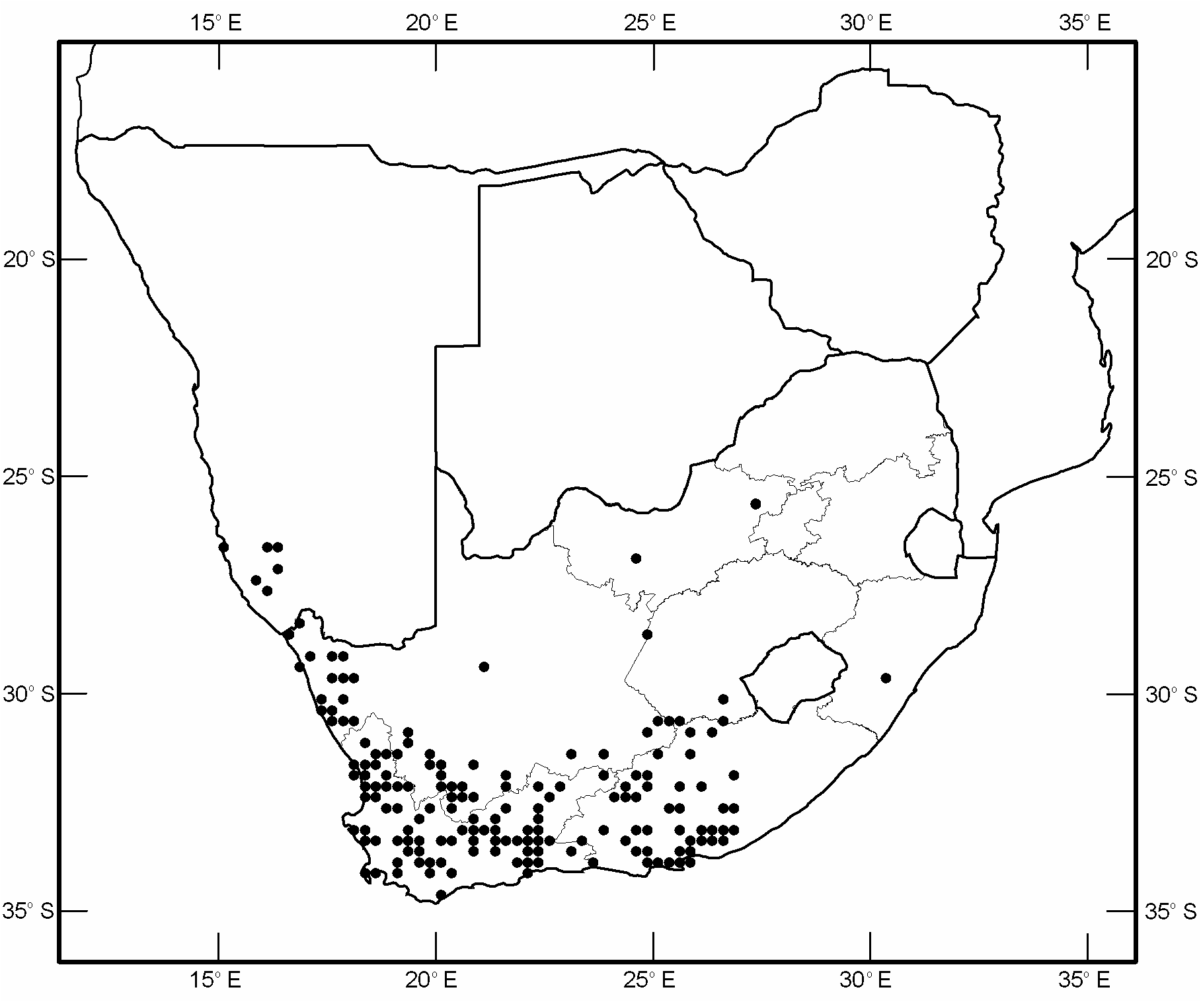
Type locality: The type specimens of A. andrenoides are merely labelled ‘ Capland Krebs S. ’ and it is not known exactly where Krebs collected them. Now that the distribution of the species is well understood I designate an area 18 km N Sutherland (32°15'S: 20°43'E) as type locality. This area is where the road between Sutherland and Williston crosses the Renoster River. This place is selected for two reasons – specimens similar to the types have been collected there, and the locality is central with respect to the known range GoogleMaps .
Additional material examined: NAMIBIA: 4♂ 3♀ 8 km N Lüderitz: Agate Beach , 2615CA, 31.viii.1983, Stuckenberg & Londt, arid vegetated dunes ( NMSA) ; 4♂ 6♀ 3 km E Lüderitz: Golf Club , 2615CA, 31.viii.1983, Londt & Stuckenberg, arid rocky slopes ( NMSA) ; 2♂ 3♀ 10 km W Aus , 2616CA, 30. viii.1983, Londt & Stuckenberg, sparse grassland small woody plants ( NMSA) ; 1♂ 5 km E of Aus , 2616CB, 30.viii.1983, Londt & Stuckenberg, open veld with low green grass & shrubs ( NMSA) ; 1♂ 1♀ Lüderitz, Grossebucht , 26°43'S: 15°07'E, 7.ix.2005, Gess ( AMGS) GoogleMaps ; 1♂ 1♀ 72 km S Aus , 2716AB, 1.ix.1983, Stuckenberg & Londt, broken veld in dry river bed open area ( NMSA) ; 1♂ 1♀ Klinghardt Mts [27°20'S: 15°45'E], 26 x.1977, Whitehead ( SAMC) GoogleMaps ; 1♂ Klinghartsberge , 5.ix.1980, Whitehead ( SAMC) ; 2♂ 5♀ Chamnaub , 27°43'S: 16°05'E, 28.viii.2002, Gess, on ground ( AMGS) GoogleMaps . SOUTH AFRICA: 1♂ Rustenburg [25°40'S: 27°15'E], 4 x.69 ( BMNH) GoogleMaps ; 1♂ Vryburg [26°57'S: 24°44'E], Griqualand West, x.1939, Mus. Staff ( SAMC) GoogleMaps ; 5♂ 15♀ 40 km S Ochta Mine, Richtersveld , 2816BD, 2.ix.1983, Londt & Stuckenberg, mixed Karoo bush with few flowers ( NMSA) ; 1♀ Richtersveld , 1 km E Grootderm, 2816DA, 2.ix.1983, Londt & Stuckenberg, Foot of small hill ( NMSA) ; 1♂ 3♀ Richtersveld N Park, 1.5 km from Helskloof gate, 28°18'S: 16°57'E, 8.ix.1996, Gess ( AMGS) GoogleMaps ; 2♀ 16 km S Senderlingsdrif , 28°18'53"S: 16°56'06"E, 27. viii.2002, Londt, 390 m, rocky hillside ( NMSA) GoogleMaps ; 1♂ 1♀ 25 km S Senderlingsdrif , 28°22'27"S: 16°54'58"E, 27.viii.2002, Londt, 210 m, sandy drainage ( NMSA) GoogleMaps ; 1♂ 1 km N Kuboes, Richtersveld , 28°25'30"S: 16°59'30"E, 1.ix.1989, Londt, Stuckenberg & Croeser, 200 m, rocky E slope Euphorbia scrub ( NMSA) GoogleMaps ; 2♂ 6 km W Kuboes, Richtersveld , 28°27'00"S: 16°58'30"E, 1.ix.1989, Stuckenberg, Londt & Croeser, sandy area with succulents ( NMSA) GoogleMaps ; 1♀ Kimberley [28°44'S: 24°46'E], x.1913, Power ( SAMC) GoogleMaps ; 1♀ Bushmanld [Bushmanland] Jackals Water [29°03'S: 17°54'E], x.1911, Lightfoot ( BMNH) GoogleMaps ; 1♀ 9 km S Lekkersing, Richtersveld , 29°03'30"S: 17°07'30"E, 2.ix.1989, Londt, Stuckenberg & Croeser, 300 m, Karragab kloof rocky area ( NMSA) GoogleMaps ; 1♂ 2♀ 18 km S Lekkersing, Richtersveld , 29°07'00"S: 17°08'00"E, 2.ix.1989, Londt, Stuckenberg & Croeser, 200 m, arid scrub succulents ( NMSA) GoogleMaps ; 1♂ Klipfontein [29°13'S: 17°40'E], Peringuey ( SAMC) GoogleMaps ; 1♂ nr Klipfontein , 28 x.1967, JacotGuillarmod ( AMGS) ; 1♂ Steinkop, Anenous Flats [29°14'S: 17°37'E], 14.ix.1992, Manning ( NMSA) GoogleMaps ; 2♂ 8♀ 50 km NE Grootderm, Richtersveld , 29°19'00"S: 16°55'00"E, 3.ix.1989, Londt & Stuckenberg, 350 m, sandy valley below a rocky hillside ( NMSA) GoogleMaps ; 1♂ Kenhart [29°21'S: 21°09'E] area, x.1939, Mus. Staff ( SAMC) GoogleMaps ; 2♂ 2♀ O’okiep [29°36'S: 17°52'E], 4 x.1885 (2♀), 18 xi.1885 (1♂), 19 xi.1886 ( 1♂] LP [Peringuey] ( SAMC) ; 1♀ O’okiep, ix.1890, Lightfoot ( ZSMC) ; 1♀ P Maritzburg [Pietermaritzburg, 29°37'S: 30°23'E], i.1940, Lawrence ( SAMC) GoogleMaps ; 1♀ ‘ Springbok [29°40'S: 17°53'E], x.1951 ( NMSA) GoogleMaps ; 2♀ Naib or Bushmanland, Btw [between] Springbok [29°40'S: 17°53'E] & Pella, x.1939, Mus. Staff ( SAMC) GoogleMaps ; 2♂ Hester Malan N R [now Goegap Nat. Res., 29°40'S: 18°00'E], 26.ix & 14 x.1987 1987, Stuck ( SAMC) GoogleMaps ; 1♂ 1?, Spectakel [29°42'S: 17°38'E], 12. xi.1885 ( SAMC) GoogleMaps ; 1♂ 11 mi [c. 18 km] NNE Hondeklipbaai , 3017AB, 8.ix.1972, Irwin, 200 ft [c. 60 m], reddish sand shrubs ( NMSA) ; 1♀ Hondeklipbaai , 3017AD, 8.ix.1972, Irwin, coastal dunes ( NMSA) ; 2♂ 12 km W Soutfontein , 3017DA, 4.ix.1981, Londt, Schoeman & Stuckenberg, Succulent Karoo ( NMSA) ; 1♂ 1♀ Garies , 3017DB, 9.ix.1972, Irwin, 640 ft [c. 195 m] ( NMSA) ; 1♂ 2♀ 10 km E Garies , 3017DB, 3.ix.1981, Londt, Schoeman & Stuckenberg, Succulent Karoo ( NMSA) ; 1♂ 4♀ 10 km W Garies , 3018CA, 3.ix.1981, Londt, Schoeman & Stuckenberg, Broken veld ( NMSA) ; 2♀ Bowesdorp [30°09'S: 17°18'E], xi.1931, Museum Staff ( SAMC) GoogleMaps ; 3♂ 2♀ Kamieskroon [30°12'S: 17°56'E], ix.1936 (1♂ 1♀), xi.1936 (2♂ 1♀), Museum Staff ( SAMC) GoogleMaps ; 2♀ Btw Kamieskroon & Springbok, x.1939, Mus. Staff ( SAMC) ; 1♂ Smithfield [30°13'S: 26°32'E], 1909, Kannemeyer ( SAMC) GoogleMaps ; 3♂ 4♀ Wallekraal [30°24'S: 17°31'E], Namaqualand, x.1950, Mus. Expd. ( SAMC) GoogleMaps ; 1♂ 50 km NE Colesberg , 30°31'S: 25°33'E, 28 x.1991, Londt, 1400 m, grass rocky outcrops ( NMSA) GoogleMaps ; 1♂ Garies [30°33'S: 17°59'E], 28 xii.1885, LP [Peringuey] ( SAMC) GoogleMaps ; 4♂ 3♀ 9 km S Garies [30°33'S: 17°59'E], x.1967, Gess ( SAMC) GoogleMaps ; 20♂ 5♀ Klip Vlei, Garies [30°33'S: 17°59'E], xi.1931, Museum Staff ( SAMC) GoogleMaps ; 1♂ Outiep, Garies [30°33'S: 17°59'E], ix.1935, du Toit ( SAMC) GoogleMaps ; 5♂ 1♀ Norval’s Pont [Norvalspont, 30°38'S: 25°27'E], 16.ix.1959, Greathead ( BMNH) GoogleMaps ; 1♂ 1♀ Caledon R. Bet. [between] BethulieAliwal North [30°42'S: 26°42'E], x.1935, Mus. Staff ( SAMC) GoogleMaps ; 11♂ 9♀ Colesberg [30°44'S: 25°06'E], x.1935 (1♂ 1♀), xi.1939, Mus. Staff ( SAMC) GoogleMaps ; 5♂ 13♀ 1?, Venterstad [30°47'S: 25°48'E] Region, x.1935 (4♂ 12♀), xi.1935 GoogleMaps ( 1♀ 1?], Mus. Staff ( SAMC) ; 11♂ 9♀ 1?, Van Schalkwyks Kraal [30°52'S: 25°52'E], Venterstad Div [Division], x.1935, Mus. Staff ( SAMC) GoogleMaps ; 1♂ 30 km S Colesberg , 30°53'S: 24°50'E, 28 x.1991, Londt, 1400 m, open area flowers ( NMSA) GoogleMaps ; 1♂ 2♀ 17 m [miles, c. 27 km] S Loeriesfontein [30°58'S: 19°27'E], ix.1961, S.A.M. ( SAMC) GoogleMaps ; 5♂ 1♀ 1?, Dreunberg [30°58'S: 26°23'E], Burghersdorp, Albert Dist. , xi.1939, Mus. Staff ( SAMC) GoogleMaps ; 8♂ 9♀ Burghersdorp [30°59'S: 26°19'E], xi.1939, Mus. Staff ( SAMC) GoogleMaps ; 1♀ Burghersdorp [30°59'S: 26°19'E], Albert Dist. , x.1935, Mus. Staff ( SAMC) GoogleMaps ; 11♂ 7♀ Albert Dist., Btw [between] Burghersdorp [30°59'S: 26°19'E] & Nooitgedacht, x.1935, Mus. Staff ( SAMC) GoogleMaps ; 1♂ 3♀ 45 km N Vanrhynsdorp , 3118BA, 4.ix.1981, Londt, Schoeman & Stuckenberg, Succulent Karoo ( NMSA) ; 1♂ 5♀ Knersvlakte , 3118BC, 2.ix.1981, Londt & Stuckenberg, rocky hillside veget Succulent Karoo ( NMSA) ; 1♂ 3♀ 7 mi [c. 11 km] N Vanrhynsdorp , 3118BC, 10.ix.1972, Irwin, 400 ft [c. 120 m], red dunes ( NMSA) ; 4♀ Hantamsberg summit, 3119BD, 15 xi.1986, Quickelberge & Londt, 1600 m, rocky macchia ( NMSA) ; 1♀ 17 km NW Touwsrivier , 3319BD, 20.xi.1986, Londt & Quickelberge, 900 m, sand and tall bush military area ( NMSA) ; 1♀ Hantamsberg , 3119BD, 23 x.1986, Schoeman ( NMSA) ; 1♀ Worcester , 3319CB, 11.ix.1981, Londt, Schoeman & Stuckenberg, near dam Karroid Broken Veld ( NMSA) ; 1♂ Top of Botterkloof Pass , 3119CD, 13.ix.1972, Irwin, 2230 ft [c. 680 m], white sand dune assoc ( NMSA) ; 1♀ 10 km W Williston , 3120BD, 15 xi.1986, Londt & Quickelberge, 1060 m, sand Acacias ( NMSA) ; 1♂ 40 km SE Calvinia, Middelpod Rd , 3120CA, 17 xi.1986, Londt & Quickelberge, 1240 m, dry woody scrubland ( NMSA) ; 2♂ 3♀ 56 km N Beaufort West ( Loxton Rd ), 3122CD, 13 xi.1986, Londt & Quickelberge, 1520 m, flat Karoo scrubland ( NMSA) ; 2♂ 1♀ Bitterf [Bitterfontein, 31°02'S: 18°16'E], x.1885 ( SAMC) GoogleMaps ; 1♂ 33 km NE Nieuwoudtville, 1 km W Gannabos [31°14'S: 19°15'E], 17. ix.2002, Barkemeyer ( NMSA) GoogleMaps ; 2♂ Knersvlakte [31°15'S: 18°45'E], x.1939, Mus. Staff ( SAMC) GoogleMaps ; 4♂ 3♀ Knersvlakte , ix.1941, Mus. Staff ( SAMC) ; 1♂ 4♀ Knersvlakte , x.1950, Mus Expd ( SAMC) ; 1♂ Nieuwoudtville, Brandkop [31°15'S: 19°11'E], ix.1941, Mus. Staff ( SAMC) GoogleMaps ; 1♂ 5 km N Nuwerus , 31°06'S: 18°20'E, 28.viii.1995, Londt, 390 m, rocky hilltop vegetation ( NMSA) GoogleMaps ; 1♂ 4♀ Knersvlakte [31°15'S: 18°45'E] North of Van Rhynsdorp , 6–9 x.1964, Stuckenberg ( NMSA) GoogleMaps ; 7♂ 7♀ Steynsburg [31°20'S: 25°50'E] Div., x.1935, Mus. Staff ( SAMC) GoogleMaps ; 1♂ 2♀ Hantamsberg summit, 31°20'27"S: 19°48'55"E, 6 xi.2002, Londt, 1500 m, thick montane veget on pass to mast ( NMSA) GoogleMaps ; 1♀ Hantamsberg summit, 31°20'57"S: 19°48'17"E, 6 xi.2002, Londt, 1590 m, Karoo scrub nr dams rocky area ( NMSA) GoogleMaps ; 1♂ 2♀ Van Rhyn’s pass [31°23'S: 19°00'E], 4–5 xi.1933, van Son ( NMSA) GoogleMaps ; 1♂ Top of Van Rhyns Pass , 19 xi, JO [Ogilvie] ( AMNH) ; 1♀ Foot of Van Rhyns Pass , 21 xi, WPC [Cockerell] ( AMNH) ; 1♀ Nieuwoudtville [31°23'S: 19°06'E], 19 xi, Macgregor ( AMNH) GoogleMaps ; 1♀ Nieuwoudtville , 19.xi, LO [Ogilvie] ( AMNH) ; 2♂ 2♀ Melton Wold, Nieuweveld, Victoria W [Victoria West, 31°24'S: 23°07'E], x.1935, Museum Staff ( SAMC) GoogleMaps ; 3♂ 2♀ Victoria West , 14 x.1966, SAM ( SAMC) ; 2♂ 4♀ Richmond Dist. [31°25'S: 23°56'E], xi.1939, Mus. Staff ( SAMC) GoogleMaps ; 5♂ 3♀ Olifants River [31°27'S: 18°32'E] bet. [between] Citrusdal & Clanwilliam ( SAMC) GoogleMaps ; 1♀ Olifants River [31°27'S: 18°32'E] betw [between] Klawer & Clanwilliam ( SAMC) GoogleMaps ; 1♂ Middelburg [31°29'S: 25°01'E], xii.1959, Kruger ( BMNH) GoogleMaps ; 1♂ 1♀ Middelburg , 20 xi.1959, Greathead ( BMNH) ; 3♂ 4♀ Middelburg Div , x.1935 (1♂), xi.1935, Mus. Staff ( SAMC) ; 1♀ Namaqualand, Dutoitsbaai [31°30'S: 18°03'E], 27 xi.1976, Whitehead ( SAMC) GoogleMaps ; 2♂ 2♀ Van Rhyn’sdorp [ Vanrhynsdorp , 31°37'S: 18°44'E], 6–8 xi.1933, van Son ( NMSA) GoogleMaps ; 5♀ v. Rhynsdorp [ Vanrhynsdorp ], viii.1927, Brauns ( NMSA) ; 1♂ v Rhynsdorp [Vanrhynsdorp], vii–viii.1927, van Son ( NMSA) ; 3♂ 1♀ Augusfontein ( Calvinia ) [Augustfontein, 31°37'S: 19°22'E], ix.1947, Mus Exp ( SAMC) GoogleMaps ; 5♂ 3♀ 14 km N Strandfontein , 31°38'S: 18°15'E, 29.viii.1995, Londt, 120 m, red ground flowers ( NMSA) GoogleMaps ; 7♂ 7♀ 27 km S Calvinia, Kieskieberge , 31°40.00'S: 19°48.84'E, 15 xi.2008, Londt, 1270 m, rocky area tall fynbos near stream ( NMSA) GoogleMaps ; 1♀ Kruidfontein, 40 km S Williston, 31°40'06"S: 20°51'30"E, 11 xi.1998, Londt, 1110 m, Leendertsrivier area ( NMSA) GoogleMaps ; 1♀ 23 km N Middelpos, 31°44'S: 20°14'E, 29 xi.1990, Whittington & Londt, 1170 m, at Kookfontein River ( NMSA) GoogleMaps ; 1♂ 1♀ 1 km S Strandfontein , 31°46'00"S: 18°14'00"E, 5.ix.1989, Londt, Stuckenberg & Croeser, shallow valley scrub succulents & macchia ( NMSA) GoogleMaps ; 1♀ Gifberg Pass 21 km S Vanrhynsdorp, 31°46'12"S: 18°45'59"E, 8. xi.2002, Londt, 540 m, montane macchia ( NMSA) GoogleMaps ; 1♂ Gifberg 23 km S Vanrhynsdorp, 31°47'S: 18°46'E, 2–4 xi.1991, Londt, 600 m, flat summit ( NMSA) GoogleMaps ; 1♀ 5 km S Doringbaai , 31°51'S: 18°16'E, 29.viii.1995, Londt, 90 m, red ground flowers ( NMSA) GoogleMaps ; 2♀ Nieu Bethesda village , 31°52'S: 24°33'E, 11 x.1996, Londt, 1290 m, bush along dry river ( NMSA) GoogleMaps ; 3♂ 1♀ Longhill Nature Res , 5 km N Queenstown, 31°52'S: 26°53'E, 3 xii.1989, Londt, 1350 m, Acacia savannah ( NMSA) GoogleMaps ; 1♀ Queenstown , [31°54'S: 26°53'E], 20.viii.1962, Busse ( AMGS) GoogleMaps ; 2♂ Clanwilliam Nardouw [31°55'S: 18°45'E], ix.1941, Mus. Staff ( SAMC) GoogleMaps ; 1♀ 2 km SW Middelpos , 31°55'25"S: 20°13'11"E, 4 xi.2002, Londt, 1200 m, Karoo scrub ( NMSA) GoogleMaps ; 1♀ Mw [?] Kloof, Fraserburg [31°55'S: 21°31'E], xi.1935, Mus. Staff ( SAMC) GoogleMaps ; 1♂ 3♀ GraaffReinet, Wapadsberg Pass [31°56'S: 24°55'E], 23 xii.1973, Whitehead, 4200' [c. 1280 m] ( SAMC) GoogleMaps ; 4♂ 11♀ Murraysburg [31°57'S: 23°46'E] Dist., xi.1935, Mus. Staff ( SAMC) GoogleMaps ; 1♂ 4.5 mi [c. 7 km] S Elandsbaai, 3218AD, 17.ix.1972, Irwin, 50 ft [c. 15 m], coastal sand plain ( NMSA) ; 2♂ 2.5 mi [c. 4 km] S Elandsbaai, 3218AD, 16.ix.1972, Irwin, 30 ft [c. 9 m], coastal sand dunes ( NMSA) ; 1♂ 2♀ 32 km NE Clanwilliam, Brandewyn R., 3219AA, 2–3 x.1977, Miller ( NMSA) ; 2♂ 2 mi [c. 3 km] NNE Pakhuis Farm, Pakhuis Mts , 3219AA, 14.ix.1972, Irwin, 1800 ft [c. 550 m] ( NMSA) ; 1♂ 1♀ Swartkop 31 km NW Sutherland, 3220BA, 18–19 xi.1986, Londt & Quickelberge, 1600 m, rocks woody macchia ( NMSA) ; 1♂ 1♀ 10 km S Sutherland, Swaarweerberg , 3220BC, 19.xi.1986, Londt & Quickelberge, 1600 m, rocks woody macchia ( NMSA) ; 8♂ 11♀ Moordenaars Karoo, Swanepoel [3220DD], x.1952, Mus Expd ( SAMC) ; 1♂ 2♀ Molteno Pass 35 km NW Beaufort West, 3222AB, 11 xi.1986, Londt & Quickelberge, 1500 m, low hilltop macchia ( NMSA) ; 1♂ Karoo National Park , 15 km N Beaufort West, 3222AB, 12 xi.1986, Londt & Quickelberge, dry Acacia woodland ( NMSA) ; 1♂ 4♀ KleinVis Riv , 32 km NW Somerset East, 3225CB, 28 x.1978, Miller & Londt, river bank ( NMSA) ; 1♀ Kommandodrifdam , 45 km E Cradock, 3226AA, 28 x.1978, Miller & Londt, river below dam wall ( NMSA) ; 1♂ 1♀ Roggeveld between Sutherland–Middelpos , 32°S 20°E, 14 xi.1987, Stuckenberg ( NMSA) GoogleMaps ; 9♂ 9♀ Bulhoek [32°01'S: 18°47'E], Klaver – Clanw [between Klawer & Clanwilliam]., x.1950, Mus. Expd. ( SAMC) GoogleMaps ; 1♀ Bulshoek [Bulhoek] Clw [Clanwilliam], xii.1956, SAM ( SAMC) ; 1♂ 1♀ 23 km SE Middelpos , 32°01'S: 20°25'E, 5 xi.1991, Londt, 1100 m, Visrivier Brandekraal ( NMSA) GoogleMaps ; 1♂ 3♀ 63 km N Sutherland , 32°01'12"S: 20°22'50"E, 9 xi.1998, Londt, 1080 m, dry rocky valley ( NMSA) GoogleMaps ; 2♂ 5♀ Doornplaats farm 35 km NW GraaffReinet, 32°02'33"S: 24°17'38"E, 27 x.2004, Londt, 1285 m, rocks & Acacia (NMSA) GoogleMaps ; 1♀ Cederberg Mts, Travelers Rest, 21.5 km ENE Clanwilliam, 32°04'45'S: 19°05'00"E, 14 xi.1996, Irwin, 400 m, Branywine River bed ( NMSA) ; 2♂ 1♀ Biedouw Valley , 32°06'S: 19°14'E, 1–12. ii.1991, Picker, 350m, Succulent Karoo ( NMSA) GoogleMaps ; 1♂ Biedouw valley Clanwilliam District, 32°06'S: 19°19'E, 22 xii.1987, Picker ( NMSA) GoogleMaps ; 2♂ Biedou Valley , 32°06'00"S: 19°19'00"E, 6.ix.1989, Londt, Stuckenberg & Croeser, 300 m, rocky gentle N slope scrub & wild flowers ( NMSA) GoogleMaps ; 2♀ Ondervisrivier 50 km N Sutherland , 32°06'59"S: 20°23'02"E, 9 xi.1998, Londt, 1320 m, dry river valley ( NMSA) GoogleMaps ; 3♂ 2♀ Tankwa Karoo, Renoster Riv [32°07'S: 20°07'E], xi.1952, Mus. Expd. ( SAMC) GoogleMaps ; 1♂ 1♀ Jakkals R [ River 32°08'S: 18°30'E], 5.x.1967, Gess, Strandveld ( SAMC) GoogleMaps ; 3♂ 1♀ Pakhuis Pass [32°08'S: 19°00'E], 17–19 x.1964, Stuckenberg, 950 m ( NMSA) GoogleMaps ; 2♂ 2♀ Clanwilliam Dist Biedouw Valley , 32°08'S: 19°14'E, 5–7.ix.1987, Mansell ( SANC) GoogleMaps ; 1♂ 1♀ Biedouw Valley [32°08'S: 19°14'E], 24.ix.1989, Picker & Leon ( NMSA) GoogleMaps ; 1♀ Graafwater [32°09'S: 18°36'E], x.1947, Mus. Exp. ( SAMC) GoogleMaps ; 1♂ 1♀ Pakhuis Pass [32°09'S: 19°02'E], Clanwilliam , ix.1942, Mus. Staff ( SAMC) GoogleMaps ; 1♀ Pakhuis Pass [32°09'S: 19°02'E], xi.1961, SAM ( SAMC) GoogleMaps ; 1♂ 1♀ East of Pakhuis Pass [32°09'S: 19°02'E], ix.1947, Mus Exp ( SAMC) GoogleMaps ; 1♂ 4♀ Thee Kloof [Teekloof 32°10'S: 21°37'E], Fraserburg Div., xi.1935, Mus. Staff ( SAMC) GoogleMaps ; 1♂ 1♀ Nieuwveldt [32°10'S: 22°20'E], Beaufort W [West] Dist , xi.1935, Museum Staff ( SAMC) GoogleMaps ; 1♂ 7♀ 3 km E Cradock , 32°10'02"S: 25°40'09"E, 29 x.2004, Londt, 956 m, Acacia scrubland with many wild flowers ( NMSA) GoogleMaps ; 3♂ 2♀ Clan William [Clanwilliam, 32°11'S: 18°54'E], ix.1928, Brauns ( NMSA) GoogleMaps ; 2♂ 3♀ 31 km N Sutherland , 32°11'S: 20°36'E, 6 xi.1991, Londt, 1600 m, Besemgoedkop and area ( NMSA) GoogleMaps ; 3♂ 3♀ Cradock [32°11'S: 25°37'E], 18. ix.1959, Greathead ( BMNH) GoogleMaps ; 4♂ 4♀ Klipkraal, Cradock Dist. [32°11'S: 25°37'E], x.1935, Mus. Staff ( SAMC) GoogleMaps ; 6♂ Besemgoedkop 31 km N Sutherland, 32°11.34'S: 20°36.08'E, 19 xi.2008, Londt, 1600 m, Karoo scrub stony ground ( NMSA) GoogleMaps ; 1♂ 5♀ Excelsior farm GraaffReinet district , 32°11'16"S: 24°49'01"E, 28 x.2004, Londt, 1408 m, rocky slope Rhus sp ( NMSA) GoogleMaps ; 5♂ 4♀ Besemgoedkop 31 km N Sutherland, 32°11'21"S: 20°36'03"E, 8 xi.1998, Londt, 1670 m, rocky ridge Macchia ( NMSA) GoogleMaps ; 1♀ Molteno Pass nr Beaufort West , 32°12'S: 22°33'E, 14 xii.1988, Eardley ( SANC) GoogleMaps ; 4♂ 8♀ Klipdrift farm 35 km SW GraaffReinet, 32°12'27"S: 24°20'27"E, 27 x.2004, Londt, 900 m, Acacia pastureland ( NMSA) GoogleMaps ; 4♀ Leipoldville [32°13'S: 18°29'E], Eland’s Bay , xi.1948, Mus. Exp. ( SAMC) GoogleMaps ; 1♀ Karoo Nature Reserve West of GraaffReinet , 32°13'S: 24°29'E, Londt, 850 m, 8 xii.1989, Scrub Winterhoek Rd ( NMSA) GoogleMaps ; 2♀ GraaffReinet, Karoo Nature Reserve , 32°14'43"S: 24°29'28"E, 26 x.2004, Londt, 1040 m, rocky Acacia slopes ( NMSA) GoogleMaps ; 2♂ 8♀ Renoster River area 18 km N Sutherland, 32°15'S: 20°43'E, 5 xi.1991, Londt, 1300 m ( NMSA) GoogleMaps ; 4♀ same area, 32°15'10"S: 20°41'39"E, 7 xi.1998, Londt, 1290 m, Karoo macchia ( NMSA) GoogleMaps ; 1♂ same area, 32°15.21'S: 20°41.67'E, 19–20.xi.2008, Londt, 1320 m, rocky ridge stream edge ( NMSA) GoogleMaps ; 1♂ 1♀ same area, 32°16'S: 20°41'E, 26 xi.1990, Londt & Whittington, 1350 m ( NMSA) GoogleMaps ; 1♂ GraaffReinet Urquhart Caravan Park , 32°14'16"S: 24°31'42"E, 26–28 x.2004, Londt, 760 m, succulent rocky slopes ( NMSA) GoogleMaps ; 1♂ 2♀ same locality, 32°15'S: 24°33'E, 4–6 xii.1988, Londt, riverine veget sandy ground ( NMSA) GoogleMaps ; 2♀ 7 km N Beaufort West , 32°16'S: 22°34'E, 28 x.1991, Londt, 1000 m, Bottom Molteno Pass ( NMSA) GoogleMaps ; 1♀ [now defective], GraafReinet [32°17'S: 24°28'E], 24–27 x.1931, Ogilvie ( BMNH) GoogleMaps ; 5♂ GraafReinet , 19 xi.1959, Greathead ( BMNH) ; 1♀ Clanwilliam District , 32°20'20"S: 18°40'E, 8–13 x.1987, Gess ( AMGS) GoogleMaps ; 1♂ Beaufort West [32°21'S: 22°35'E], Karoo Nat Prk [National Park], 24 xi.1985, Whitehead ( SAMC) GoogleMaps ; 3♂ 1♀ 15 km E Sutherland , 32°23'S: 20°48'E, 26 xi.1990, Whittington & Londt, 1600 m, valley nr Observatory ( NMSA) GoogleMaps ; 4♂ 9♀ Touws R., Ouberg Pass [32°24'S: 20°20'E], xii.1962, SAM ( SAMC) GoogleMaps ; 1♂ Bottom Ouberg Pass , 54 km SE Sutherland, 32°24.07'S: 20°17.63'E, 21 xi.2008, Londt, 640 m, succulents low bushes ( NMSA) GoogleMaps ; 1♂ 1♀ Top Ouberg Pass , 46 km SE Sutherland, 32°24.56'S: 20°21.39'E, 21 xi.2008, Londt, 1380 m, rocky ridge Karoo scrub ( NMSA) GoogleMaps ; 17♂ 16♀ Paleisheuvel [32°28'S: 18°43'E], xi.1948, Mus Exp ( SAMC) GoogleMaps ; 2♂ Aberdeen [32°29'S: 24°05'E], xi.1935, Mus. Staff ( SAMC) GoogleMaps ; 1♂ 1♀ Tankwa Karoo [c. 32°30'S: 19°45'E], i.1948 (1♀), i.1949 GoogleMaps ( 1♂], Zinn & Hesse ( SAMC) ; 1♂ Tankwa Karoo, Kleinbrak , xi.1952, Mus Expd ( SAMC) ; 2♂ Mitchell’s Pass [32°33'S: 26°53'E], nr Ceres, 100 mi [c. 160 km] from Cape Town , 1–5. xii.1930, Simmonds ( BMNH) GoogleMaps ; 3♂ Bushmans Riv, Letjiesbosch [32°34'S: 22°16'E], xi.1935, Mus. Staff ( SAMC) GoogleMaps ; 2♂ 8 mi [c. 13 km] N Citrusdal [32°35'S: 19°01'E], ix.1961, SAM ( SAMC) GoogleMaps ; 9♂ 10♀ Citrusdal Dist. , xi.1948, Mus Exp ( SAMC) ; 3♂ 4 miles [c. 6 km] E Citrusdal , x.1969, SA Museum Expedition ( SAMC) ; 6♂ 4♀ Tankwa Karoo, Waterval [32°35'S: 20°18'E], xi.1952, Mus Expd ( SAMC) GoogleMaps ; 3♂ 2♀ Het Kruis [32°36'S: 18°45'E], x.1947, Mus Exp ( SAMC) GoogleMaps ; 1♂ Koornplanskloof , 10 km S Citrusdal, 32°40'S: 19°01'E, 4–8 x.1994, Danielssen, 200–270 m ( MZLU) GoogleMaps ; 1♂ Merweville [32°40'S: 21°31'E] dist, ii.1941, Zinn ( SAMC) GoogleMaps ; 3♂ 1♀ Bosberg Nature Res 3 km N Somerset East, 32°42'S: 26°33'E, 5 xii.1989, Londt, 850 m, mixed woodland ( NMSA) GoogleMaps ; 1♂ 4♀ Somerset East [32°43'S: 25°35'E], x.1930 (1♀), xi.1930 (1♂ 2♀), 25–30 xi.1930 (1♀), Turner ( BMNH) GoogleMaps ; 2♂ 1♀ Klein Visrivier , c. 10 km W Somerset East, 32°44'S: 25°30'E, 6 xii.1989, Londt, 800 m, rocky ridge & stream ( NMSA) GoogleMaps ; 10♂ 7♀ Lammerskraal [32°49'S: 22°15'E], Prince Albert Dist. , ix.1947, Mus Exp ( SAMC) GoogleMaps ; 1♀ c. 30 km S Kagga Kamma, Nature Reserve , 32°52.91'S: 19°44.29'E, 21 xi.2008, Londt, 570 m, Acacias Aloes streambed ( NMSA) GoogleMaps ; 36♂ 33♀ Dikbome [32°54'S: 21°22'E], Merweville, x.1952, Mus Expd ( SAMC) GoogleMaps ; 8♂ 17♀ Moordenaars Karoo, Lammerfontein [32°58'S: 20°49'E], x.1952, Mus Expd ( SAMC) GoogleMaps ; 1♂ 1♀ 14 mi [c. 22 km] SE Langebaan, 3318AA, 18.ix.1972, Irwin, 200 ft [c. 60 m], coastal dunes sandy plain ( NMSA) ; 7♂ 6♀ Gydo Myn 24 km NE P Alfred Ham [Prince Alfred Hamlet], 3319AB, 21 xi.1986, Londt & Quickelberge, 1150 m, rocky area Proteas ( NMSA) ; 1♀ 5 km W Robertson , 3319DD, 26.ix.1979, Londt, stony slopes with woody veget ( NMSA) ; 1♀ 18 km NE Touwsrivier, Jan de Boers , 3320AC, 20 xi.1986, Londt & Quickelberge, 1000 m, rocky area nr fields ( NMSA) ; 6♂ 6♀ 20 km SE Ashton , 3320CC, 25.ix.1979, Londt, stony hillside with woody vegetation ( NMSA) ; 4♂ 6♀ Montagu , hillside SE of town, 3320CC, 25.ix.1979, Londt ( NMSA) ; 1♂ 1♀ Swartberg Pass Gamka Rd , 3321BD, 10 xi.1986, Quickelberge & Londt, N slope rocky area ( NMSA) ; 1♂ 6 km S Prince Albert , 3322AA, 10 xi.1986, Londt & Quickelberge, 780 m, sand Acacias ( NMSA) ; 1♀ Swartberg Pass , 3322AC, 10 xi.1986, Londt & Quickelberge, 1250 m, N slope Proteas ( NMSA) ; 1♂ 15 km SE Oudtshoorn , 3322CB, 9 xi.1986, Londt & Quickelberge, macchia/rocky hill ( NMSA) ; 15♂ 15♀ 9 km SW Willowmore , 3323AD, 30–31 x.1978, Londt & Miller, open Karoo scrub ( NMSA) ; 1♂ 1 km NE Uniondale , 3323CA, 31.x.1978, Miller & Londt, rocky hillside scrub ( NMSA) ; 1♀ Gamtoos Valley Bush, Hankey area , 3324DA, 5 xii.1967, Stuckenberg ( NMSA) ; 4♂ 2♀ Elandsberg Mts South Cockscomb Peak, Patensie area , 3424DB [actually 3324DB], 1 xii.1967, Stuckenberg ( NMSA) ; 1♀ Otterford Forerstry Reserve, Hankey area , 3325CC, 1–10 xii.1967, Stuckenberg ( NMSA) ; 14♂ 7♀ 15 km SE Kirkwood , 3325DA, 4 xi.1978, Miller & Londt, open bushveld scrub ( NMSA) ; 4♂ Louterwater , 3323DC, 13 xii.1979, Londt & Stuckenberg, grass & hillside macchia ( NMSA) ; 3♀ Willowmore [33°17'S: 23°29'E], Brauns ( ZSMC) GoogleMaps ; 23♂ 10♀ Koop Siding, Laingsburg [33°00'S: 21°00'E], x.1952, Mus Expd ( SAMC) GoogleMaps ; 5♂ 6♀ Hopefield [33°04'S: 18°21'E], ix.1960, SAM ( SAMC) GoogleMaps ; 1♂ Double Drift, Andres Oslo Kudu Res , 33°06'S: 26°47'E, 14 xii.1988, Weaving ( AMGS) GoogleMaps ; 2♂ Koop Siding [33°07'S: 21°16'E], xi.1939, Mus. Staff ( SAMC) GoogleMaps ; 17♂ 22♀ Grahamstown, Vacate [33°09'S: 26°19'E], 21 x (4♂ 3♀), 16 xi (3♂ 4♀), 22 xi (7♂ 14♀), 27 xi (1♂ 1♀), 30.xi.1981 (2♂), Gess ( AMGS) GoogleMaps ; 1♀ Prince Albert Dist., Tier berg ( Study site), 33°10'S: 22°16'24"E, 26 xi.–5 xii.1987, Gess ( AMGS) GoogleMaps ; 1♂ 1♀ De Ere 10 km NE Gydo Pass , 33°10'S: 19°23'E, 21 xi.1984, Eardley ( SANC) GoogleMaps ; 3♂ 4♀ Resolution [33°10'S: 25°37'E], 17 x.1927 (1♂ 1♀), 21.x.1927 (1♀), 22 x.1927 (1♂), 26 x.1927 (1♀), 7 xi.1927 (1♂), 12 xi.1927 (1♀), 17 xi.1928 (1♀), Walton ( NMSA) GoogleMaps ; 2♂ Resolution [33°10'S: 25°37'E], x–xi.1928, Walton ( SAMC) GoogleMaps ; 1♀ 2 km E Alicedale , 33°19'07"S: 26°06'12"E, 23.x.2004, Londt, 310 m, dry rocky hillside with succulent vegetation ( NMSA) GoogleMaps ; 3♂ 2♀ 6 km E Alicedale, 33°10'S: 26°07'E, 21 xi.1990, Whittington & Londt, 600 m, New Years Dam area ( NMSA) GoogleMaps ; 1♂ Grahamstown, Hell Port [Heliport, 33°11'S: 26°21'E], 13 xi.1958, JacotGuillarmod ( AMGS) GoogleMaps ; 1♂ Laingsburg [33°12'S: 20°51'E], xi.1910, Lightfoot ( SAMC) GoogleMaps ; 7♀ 15 km NW Grahamstown , 33°12'S: 26°24'E, 20 xi.1990, Whittington & Londt, 500 m, Clifton farm hillside ( NMSA) GoogleMaps ; 2♂ 4♀ Matjesfontein [Matjiesfontein, 33°13'S: 20°35'E], 6–15 x.1928 (1♂), 16–21 x.1928 (1♀), 1–6 xi.1928 (1♀), 1–18.xii.1928 (1♂ 1♀), 19–31 xii.1928 (1♀), Turner ( BMNH) GoogleMaps ; 11♂ 10♀ 7–10 mi [c. 14 km] SW Matjiesfontein , 15.x.1966, SAM ( SAMC) ; 4♂ Prince Albert Rd [33°13'S: 22°03'E], xi.1931, Turner ( BMNH) GoogleMaps ; 1♀ Prince Albert , 26.ix.1927, AcUS [?] ( NMSA) ; 2♂ Prince Albert Rd Stn [Station, 33°13'S: 22°03'E], vii.1945, Hesse ( SAMC) GoogleMaps ; 1♀ Swartebergen, Prince Albert Div [33°13'S: 22°03'E], xi.1935, Mus. Staff ( SAMC) GoogleMaps ; 2♂ 1♀ 1?, Zwartberg Pass , P Albert Div, xi.1929, Barnard, 5000–6000 ft ( SAMC) ; 4♂ 8♀ Klaarstroom, Prince Albert , x.1952, Mus Expd ( SAMC) ; 1♂ Lammerskraal, Prince Albert Distr. , ix.1947, Mus. Exp ( SAMC) ; 2♂ 1♀ Ecca Pass Nature Res , 20 km NE Grahamstown, 33°13'07"S: 26°37'38"E, 21 x.2004, Londt, 475 m, N slope thicket ( NMSA) GoogleMaps ; 1♂ 5 km S Laingsburg, 33°14'S: 20°52'E, 25 xi.1990, Londt & Whittington, 700 m, banks Buffels River ( NMSA) GoogleMaps ; 1♂ nr Grahamstown, Penrock [Penn Rock, 33°14'S: 26°34'E], 1 xi.1924, Whitworth ( AMGS) GoogleMaps ; 2♂ 1♀ Klein Winterhoekberge 43 km SE Jansenville, 33°14'38"S: 24°50'15"E, 25 x.2004, Londt, 724 m, dry rocky hillside ( NMSA) GoogleMaps ; 1♀ 32 km E Willowmore , 33°15'S: 23°48'E, 22 xi.1990, Whittington & Londt, 650 m, dry scrub road margin ( NMSA) GoogleMaps ; 2♀ Grahamstown, Hilton , [33°15'S: 26°21'E], 6 xii.1964 (1♀) 29 xi.1966 (1♀), JacotGuillarmod ( AMGS) GoogleMaps ; 2♂ 1♀ Grahamstown, Hilton , 6 xii.1964 (1♂), 22.x.1967 (1♂ 1♀), Brothers ( AMGS) ; 2♂ Grahamstown, Hilton , 22–31.xii.1979, Gess, Malaise ( AMGS) ; 6♂ 9♀ Grahamstown, Hilton , 5 xi (2♂ 4♀), 19 xi (1♀), 9 xii.1969 (1♀), 9 x.1972 (1♀), 9 xii.1977 (1♀), 2.i.1978 (1♂), 6 xi.1981 (2♂), 6 xii.1985 (1♂ 1♀), Gess ( AMGS) ; 1♀ Constable [33°16'S: 20°18'E], xii.1962, SAM ( SAMC) GoogleMaps ; 2♂ 1♀ 70 km W Laingsburg , 33°16'33"S: 20°07'25"E, 7.xi.1998, Londt, 900 m, macchia vegetation ( NMSA) GoogleMaps ; 1♀ Tulbagh [33°17'S: 19°09'E], 17 xii.1962, Theron ( NMSA) GoogleMaps ; 11♂ 2♀ Willowmore [33°17'S: 23°29'E], 1 xii.1908 (1♂), 5 xi.1909 (1♂), 10 xi.1909 (1♂), xi.1910 (1♂), 15 x.1911 (1♂), 15 xi.1911 (1♂), 10 x.1916 (2♂), 15 x.1916 (1♂), 5 xi.1916 (1♂), xii.1922 (1♀), x.1923 (1♀), 20 xii.1923 (1♂), Brauns ( NMSA) GoogleMaps ; 2♂ 1♀ Willowmore [33°17'S: 23°29'E] Vondeling, x.1952, Mus Expd ( SAMC) GoogleMaps ; 1♀ Willowmore , 5.x.1971, JacotGuillarmod ( AMGS) ; 3♀ Slypsteen, Towerwaterkloof, Willowmore [33°17'S: 23°29'E] Dist., x.1938, Mus. Staff ( SAMC) GoogleMaps ; 2♂ 2♀ Grahamstown, Burntkraal [33°17'S: 26°29'E], 4 xii.1967 (1♂), 23.i (1♀), 1 x (1♂), 4 xii.1969 (1♂), Gess ( AMGS) GoogleMaps ; 6♂ 6♀ Grahamstown, Somerset Heights area , 33°17'52"S: 26°30'44"E, 24 x.2004, Londt, 643 m, rocky Acacia grassland ( NMSA) GoogleMaps ; 1♀ 4 km NE Steytlerville, Noorspoort , 33°18'S: 24°23'E, 22.xi.1990, Londt & Whittington, 600 m, hillside ( NMSA) GoogleMaps ; 3♂ Grahamstown, Strowan , [33°18'S: 26°28'E], 27 xi (1♂), 11 xii.1968 (1♂), 12 xi.1969 (1♂), Gess ( AMGS) GoogleMaps ; 4♂ 4♀ Grahamstown [33°18'S: 26°32'E], 19 xii.1971, Greathead ( BMNH) GoogleMaps ; 1♀ Grahamstw [Grahamstown], xi.1940, Marley ( SAMC) ; 2♂ Grahamstown , 29 xi.1964, Brothers ( AMGS) ; 1♂ 2♀ Grahamstown , xii.1954 (1♀), xi.1956 (1♂ 1♀), Martin ( AMGS) ; 1♂ Gamkas Poort [33°19'S: 21°43'E], x.1937 ( SAMC) GoogleMaps ; 1♂ 3♀ Witzenberg Vall [Valley 33°20'S: 19°30'E], Ceres District , 21–23 xii.1920, Turner, 3500 ft [c. 1065 m] ( BMNH) GoogleMaps ; 1♀ Witzenberg Vall , 19.i.1921, Turner, 3000 ft [c. 920 m] ( BMNH) ; 1♂ 13 mi [c. 21 km] NE Touws River [33°20'S: 20°02'E], 26 x.1928, Turner ( BMNH) GoogleMaps ; 1♂ 1♀ Touws R. [33°20'S: 20°02'E], 16 x.1966, SAM ( SAMC) GoogleMaps ; 2♀ 8 mi [c. 13 km] NE Touws R. [River, 33°20'S: 20°02'E], xii.1962, S.A.M. ( SAMC) GoogleMaps ; 2♀ National Road 22 mi [c. 35 km] from Touws River [33°20'S: 20°02'E], 3 x.1964, Stuckenberg ( NMSA) GoogleMaps ; 1♂ Bloutoring Sta [Station 33°20'S: 20°19'E], 30mi [c. 48km] E Touws R., xii.1962,SAM( SAMC) GoogleMaps ; 1♀ Rooinek Pass [33°20'S: 20°55'E], x.1952, Mus Exp ( SAMC) GoogleMaps ; 1♂ Bosluis Pass [33°21'S: 21°30'E], x.1952, Mus Expd ( SAMC) GoogleMaps ; 2♂ 4♀ Ceres [33°22'S: 19°19'E], xii.1920, Turner, 1500 ft [c. 457 m] ( BMNH) GoogleMaps ; 8♂ 9♀ Ceres , xi.1920, Turner ( BMNH) ; 33♂ 52♀ Upper Sources Olifants River, Ceres [33°22'S: 19°19'E], xii.1949, Mus Exp ( SAMC) GoogleMaps ; 1♂ Junction of Calvinia–Sutherland Rd nr Inverdoorn, Ceres [33°22'S: 19°19'E], 2–3 x.1959, Stuckenberg ( NMSA) GoogleMaps ; 2♂ 7♀ Matroosberg [33°23'S: 19°40'E] Sta [station], xii.1962, SAM ( SAMC) GoogleMaps ; 1♀ Ceres Div Matroosberg , i.1917, Lightfoot, 3500 ft ( SAMC) ; 2♀ Ghwarriepoort River , 18 km SW Willowmore, 33°23'S: 23°23'E, 22 xi.1990, Londt & Whittington, 900 m ( NMSA) GoogleMaps ; 1♂ Meirings Poort [Meiringspoort, 33°24'S: 22°34'E], x.1937, Mus. Staff ( SAMC) GoogleMaps ; 1♀ Suurvlakte Kluitjieswan /FR [illegible] Wolseley [33°25'S: 19°12'E], 23. xi.1972, Geertsema ( SANC) GoogleMaps ; 1♀ Malmesbury [33°27'S: 18°44'E], 5 xii.1926, Brauns ( NMSA) GoogleMaps ; 1♂ 2♀ Schoemans Poort [Schoemanspoort, 33°27'S: 22°15'E], x.1938, Mus. Staff ( SAMC) GoogleMaps ; 1♂ nr Addo [33°27'S: 25°45'E], 15 x.1959, Greathead ( BMNH) GoogleMaps ; 2♂ Modder R. [33°28'S: 18°21'E], xi.1939, Mus. Staff ( SAMC) GoogleMaps ; 1♂ Ladismith [33°29'S: 21°16'E], ix.1948, JacotGuillarmod ( AMGS) GoogleMaps ; 1♂ Addo Elephant Park, Spekboom Trail , 33°31'05"S: 25°45'43"E, 4 xi.1998, Leftwich 125 m, ( NMSA) GoogleMaps ; 3♂ 3♀ Oudtshoorn Dist [33°35'S: 22°12'E], x.1952, Mus Expd ( SAMC) GoogleMaps ; 1♀ Oudtshoorn [33°35'S: 22°12'E], 1.ix.1909, Brauns ( NMSA) GoogleMaps ; 1♂ Rust en Vrede, Oudtshoorn Dist [33°35'S: 22°12'E], x.1951, Mus Expd ( SAMC) GoogleMaps ; 3♂ 2♀ Worcester [33°36'S: 19°34'E], ix.1928 (2♂), 3–4 x.1928 (1♂), xii.1933 (2♀), Turner ( BMNH) GoogleMaps ; 1♂ Worcester [33°36'S: 19°34'E], ix.1928, Turner ( NMSA) GoogleMaps ; 3♂ Worcester , x.1923 (1♂), xi.1951 (2♂) ( NMSA) ; 2♂ Worcester , 33°37'S: 19°25'E, 5 x. (1♂), 6 x.2000 (1♂), Gess ( AMGS) GoogleMaps ; 7♂ 9♀ Karoo Botanic Garden, Worcester , 33°37'S: 19°27'E, 5 x.1993, Londt, 210 m, macchia ( NMSA) GoogleMaps ; 2♀ 18 mi [c. 29 km] E Touws R to Hondewater [33°39'S: 20°46'E], xii.1962, SAM ( SAMC) GoogleMaps ; 11♂ 1♀ Uniondale Dist. [33°39'S: 23°08'E], x.1952, Mus Expd ( SAMC) GoogleMaps ; 1♂ Hex Riv [33°41'S: 19°27'E] ( SAMC) GoogleMaps ; 1♂ Hex R., 2.i.1883 ( SAMC) ; 3♂ 1♀ Van Wyks Dorp [33°44'S: 21°28'E], x.1957 ( SAMC) GoogleMaps ; 1♀ Haarlem [33°44'S: 23°19'E], Langekloof, xi.1953, Stuckenberg ( NMSA) GoogleMaps ; 13♂ 26♀ Oudtshoorn, Zebra [Siding, 33°45'S: 22°19'E], x.1951, Mus Expd ( SAMC) GoogleMaps ; 1♂ Patiente [Patensie, 33°46'S: 24°49'E], Humansdorp, x.1938, Mus. Staff ( SAMC) GoogleMaps ; 2♂ 4♀ Groendal, Uitenhage [33°46'S: 25°24'E], x.1938, Mus. Staff ( SAMC) GoogleMaps ; 1♂ 2♀ 1?, Montagu [33°47'S: 20°07'E], x.1919, Barnard ( SAMC, 1♀ BMNH) GoogleMaps ; 1♀ Montagu , x–xi.1919 ( BMNH) ; 2♂ 1♀ Montagu , 1–21 x.1924, Turner ( BMNH) ; 5♂ 3♀ Montagu Nature Garden , 33°47'33"S: 20°07'51"E, 19.x.2005, Londt, 240 m, Succulent Karoo garden on hot N slope ( NMSA) GoogleMaps ; 1♂ 2♀ Robertson [33°48'S: 19°53'E], 25 x.1942, Anderssen ( NMSA) GoogleMaps ; 2♂ 1♀ Oudtshoorn district, Moeras River Farm (209), 33°48'S: 22°03'E, ix.2007, Davies, 525 m, dry Karoo scrub with flowers ( NMSA) GoogleMaps ; 1♀ Algoa Bay [33°50'S: 25°50'E], 27 xi.1895, Brauns ( ZSMC) GoogleMaps ; 2♂ 1♀ P [Port] Elizabeth, Swartkops [33°52'S: 25°36'E], 21 xii.1922, Brauns ( NMSA) GoogleMaps ; 1♂ 2♀ Vrolijkheid Nature Reserve , 33°54'55"S: 19°53'37"E, 20 x.2005, Londt, 234 m, dry succulent rocky hillside, Rooikat trail ( NMSA) GoogleMaps ; 2♂ 1♀ French Hoek [Franschhoek, 33°55'S: 19°07'E] 40 mi [c. 64 km] from Cape Town, xi–xii.1930, Simmonds ( BMNH) GoogleMaps ; 8♂ 3♀ Vrolijkheid Nature Reserve , 33°55'20"S: 19°53'00"E, 20 x.2005, Londt, 143 m, Acacia , Rhus scrubland on Heron trail ( NMSA) GoogleMaps ; 1♀ Cloetes Pass [33°57'S: 21°47'E], x.1937 ( SAMC) GoogleMaps ; 1♂ George [33°58'S: 22°27'E] Dist., x.1931, Thorne ( SAMC) GoogleMaps ; 1♀ Van Stadens Riv Mouth, 33°58'S: 25°14'E, 22 xii.1986, Mansell ( SANC) GoogleMaps ; 1♂ Somerset Strand [suburb of Port Elizabeth, 33°58'S: 25°35'E], 1 xi.1915, Brauns ( NMSA) GoogleMaps ; 5♂ 3♀ Good Hope Farm c. 35 km SW Robertson, 33°59'13"S: 19°36'00"E, 21–23 x.2005, Londt, 380 m, Protea , Dodonaea fynbos ( NMSA) GoogleMaps ; 1♀ 10 km NE Muizenberg , 3418AB, 28 xi.1981, Stuckenberg, coastal macchia ( NMSA) ; 1♂ 2♀ Strandfontein, GrootSandleegte , 3418BA, 10–12 x.1977, Miller ( NMSA) ; 1♂ 2♀ 5 km SW Swellendam, 3420AB, 24.ix.1979, Londt, rocky slope above Breede River ( NMSA) ; 1♂ 1♀ Faure [34°01'S: 18°44'E], 13 xi.1971, Bayliss ( AMGS) GoogleMaps ; 1♀ Tradouw Pass, Swellendam Dist. [34°02'S: 20°26'E], xi.1925, Mus. Exped. ( SAMC) GoogleMaps ; 1♂ 20 km SW Stellenbosch , 34°04'S: 18°43'E, 30.x.1991, Londt, 0 m, coast near Swartklip ( NMSA) GoogleMaps ; 8♂ 9♀ Strandfontein [34°05'S: 18°33'E], False Bay , 1 xi.1960 ( SAMC) GoogleMaps ; 1♂ R Sonder End, Oudebosch [34°05'S: 19°47'E], xi– xii.1928, Barnard, 1500 ft ( SAMC) GoogleMaps ; 3♂ Mossel B [ Bay , 34°11'S: 22°08'E], 1896, Overbeek ( SAMC) GoogleMaps ; 1♂ Bot River [34°13'S: 19°12'E], 11 xi.1933, Ogilvie ( BMNH) GoogleMaps ; 1♂ 1♀ 15 km N Agulhas , 34°43'S: 20°01'E, 16 xi.1982, Eardley ( SANC) GoogleMaps ; 1♂ Cap [unknown locality], 1837, Ludwig ( SMNS) .
Distribution, phenology (Table 3) and biology: The species is widely distributed ( Fig. 65 View Fig ), ranging from southern Namibia, down the west coast of South Africa (Northern and Western Cape Provinces) and eastwards through to the Eastern Cape Province. There are a few records that appear improbable (e.g. Rustenburg in North West Province and Pietermaritzburg in KwaZulu-Natal!) and these specimens may have been mislabelled. In addition there are a few localities from which only female specimens are known. Difficulties in separating the females of andrenoides and platygaster means that some distribution points provided for andrenoides could actually belong to platygaster (and vice versa). The species is active in the adult stage during late winter, spring and summer (July–February) although the majority of collections were made between September and December. Some specimens have been pinned together with prey items. The 20 records available to me are as follows (sex of asilid bracketed): Coleoptera : Buprestidae (♀), Coccinellidae (♀), Dermestidae (♂), Melyridae (♀), Scarabaeidae (3♂ 3♀); Diptera : Muscidae (♂); Hemiptera : Lygaeidae (♂), Pentatomidae (♂); Isoptera: Hodotermitidae (3♂ 2♀); Orthoptera : Tridactylidae (2♂). Although Scarabaeidae and Hodotermitidae dominate the sample, it is probable that andrenoides , like many other asilids, is a generalist.
Similar species: A. andrenoides can be confused with platygaster and, in a few instances, large specimens of dorsalis – especially when female specimens are involved. Although male hypandria are largely withdrawn, it is usually possible to separate the males of these species using the appearance of the distal parts of this organ.


No known copyright restrictions apply. See Agosti, D., Egloff, W., 2009. Taxonomic information exchange and copyright: the Plazi approach. BMC Research Notes 2009, 2:53 for further explanation.
|
Kingdom |
|
|
Phylum |
|
|
Class |
|
|
Order |
|
|
Family |
|
|
Genus |
Acnephalomyia andrenoides ( Wiedemann, 1828 )
| Londt, Jason G. H. 2010 |
Acnephalum cockerelli
| OLDROYD, H. 1974: 27 |
| OLDROYD, H. 1974: 72 |
| HULL, F. M. 1962: 192 |
| CURRAN, C. H. 1934: 6 |
Acnephalum punctipennis
| HULL, F. M. 1962: 192 |
| KERTESZ, C. 1909: 88 |
Acnephalum quadratum: Kertesz 1909: 88
| HULL, F. M. 1962: 192 |
| CURRAN, C. H. 1934: 5 |
| KERTESZ, C. 1909: 88 |
Acnephalum andrenoides: Hermann 1907: 8
| CURRAN, C. H. 1934: 5 |
| KERTESZ, C. 1909: 87 |
| HERMANN, F. 1907: 8 |
Dasypogon andrenoides: Wiedemann 1828: 403
| WIEDEMANN, C. R. W. 1828: 403 |
Dasypogon quadratus
| WIEDEMANN, C. R. W. 1828: 404 |