
Solanum turneroides, Chodat,
|
publication ID |
https://doi.org/ 10.1600/036364413X666624 |
|
DOI |
https://doi.org/10.5281/zenodo.6335135 |
|
persistent identifier |
https://treatment.plazi.org/id/03B0878F-FFB8-FFD3-FF43-FC9E42E4E59E |
|
treatment provided by |
Tatiana |
|
scientific name |
Solanum turneroides |
| status |
|
8. SOLANUM TURNEROIDES Chodat, View in CoL
Bull. Herb. Boissier sér. 2, 2: 814. 1902.
—TYPE: PARAGUAY. In campis arenosis pr. fl. Capibary , 5 Sep 1898–1899 (fl), E. Hassler 4396 (lectotype, here designated, G-G00076272 !; isolectotypes, BM-BM000074102!, NY-NY00172221!, UC-944864!).
Solanum gonatotrichum Bitter, View in CoL Repert. Spec. Nov. Regni Veg. 11: 230. 1912.
—TYPE: BOLIVIA. Tarija: Chiquiacá , in silva, 1000 m, 8 Mar 1904 (fl), K. Fiebrig 2732 (lectotype, here designated, M-M0090347 !, photo of lectotype [Morton neg. 8692]: F!, GH!, UC!; isolectotypes: B (destroyed), CORD!, SI!, W-W1922 –0001732!, photo of Bisolectotype [F neg. 2713]: GH!).
Solanum geniculatistrigosum Bitter, View in CoL Repert. Spec. Nov. Regni Veg. 11: 232. 1912.
—TYPE: PARAGUAY. Yaguaron, en los campos, 1 Dec 1879 (fl), R. Balansa 3132 (holotype: B (destroyed); photos of holotype [F neg 2751]: F!, G!, GH!, WIS!; lectotype, here designated, BM-BM000087589!; isolectotypes: LE!, P-P00384651!).
Solanum flavistrigosum Bitter, View in CoL Repert. Spec. Nov. Regni Veg. 12: 74. 1913.
—TYPE: PARAGUAY. Campo cerrado , Estancia Sta. Maria , 2 Jan 1897 (flower bud), J. D. Anisits 2018 (holotype: S-05–10 !).
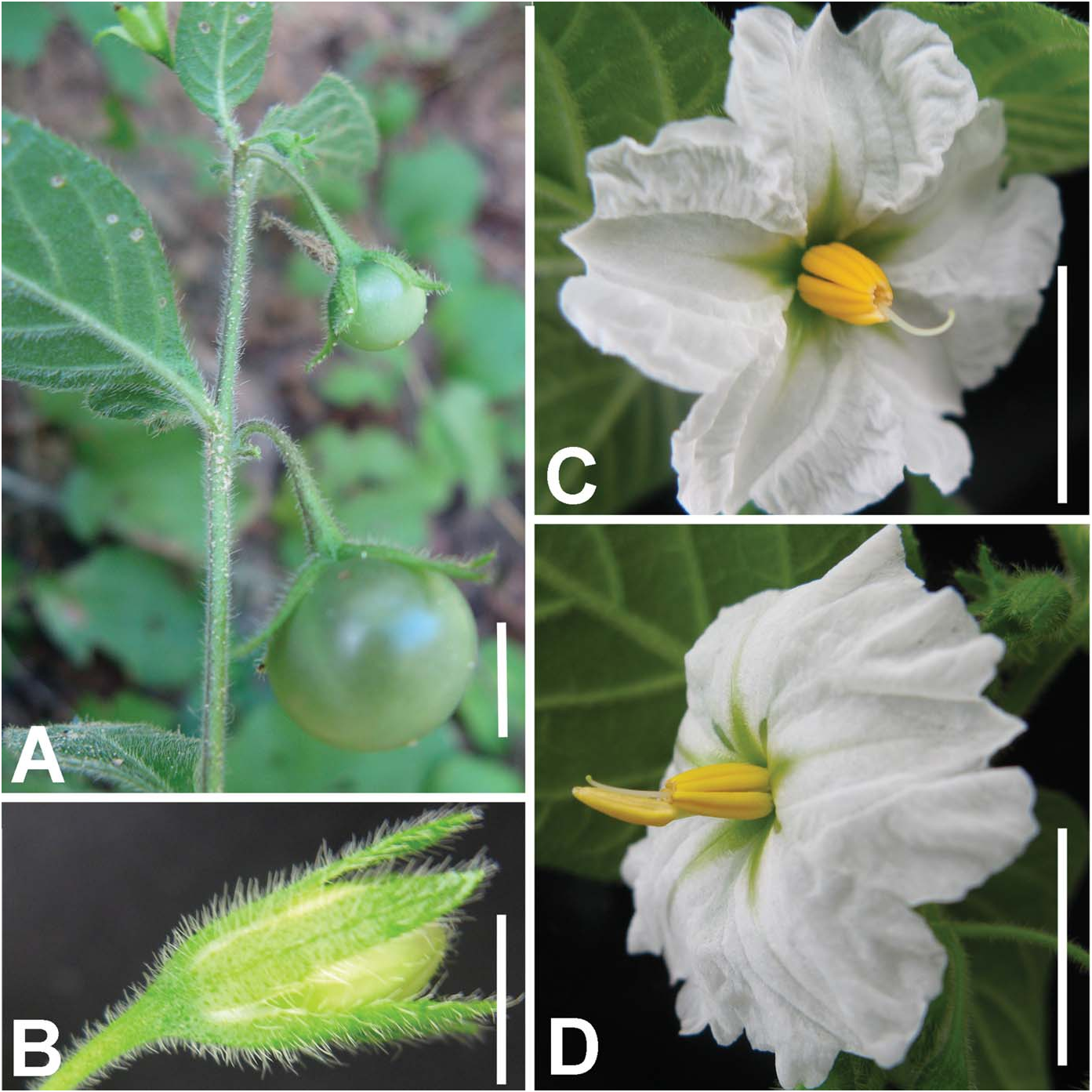
Herb, sometimes slightly woody, few- to many-branched, 2–7 dm tall. Stems sparsely to densely pubescent with straight one-celled or geniculate two-celled hairs, the straight hairs common on older growth, the geniculate hairs dense on new growth. Sympodia 2-foliate, usually geminate. Leaf blades 1–7 + 0.75 –3 cm, elliptic to elliptic-ovoid, chartaceous to membranaceous, sparsely to moderately pubescent adaxially and abaxially with 1- or 2-celled unbranched hairs, these lying flat along blade, denser along veins; base rounded to obtuse, often decurrent into petiole; apex acute; petioles 0.5–2.5 cm, moderately pubescent with unbranched hairs. Inflorescences with 1 –5 flowers, the axes sparsely to moderately pubescent with unbranched hairs; peduncle absent or nearly so; rachis absent; pedicels 5 –15 mm in flower, 12–20 mm in fruit. Flowers with the calyx 3–6 mm long, the tube 1–3 mm, the lobes 2–4 + 0.5–1.5 mm, linear-lanceolate, moderately to densely pubescent. Corolla 1–2.5 cm in diameter, rotate with abundant interpetalar tissue, chartaceous to membranaceous, white to purple, the tube 4 –10 mm, the lobes 2–4 + 1–2 mm, triangular, acute at apices, glabrous abaxially and adaxially. Stamens 3 –6 mm; upper, shorter filaments 1–2 mm, the lowermost, longer filament 3–7 mm, glabrous or pubescent; anthers 4–6 + 1–2 mm, oblong, the base cordate, the apex emarginate. Ovary glabrous; style 7–10 + 0.5 –1 mm, longer than the smaller stamens, closely appressed to larger stamen, curved near the apex; stigma to 1 mm wide. Berries 10–20 mm in diameter, globose, white to yellow when immature, maturing semitransparent, drying brown, glabrous, the mesocarp watery and held under pressure until dehiscing explosively at maturity. Seeds 10–35 per fruit, ca. 2.5 + 1.5 mm, the entire seed twisted, not flattened, with a small notch where connected to placenta, the surface with raised cell walls forming netlike projections. Figure 13 View FIG .
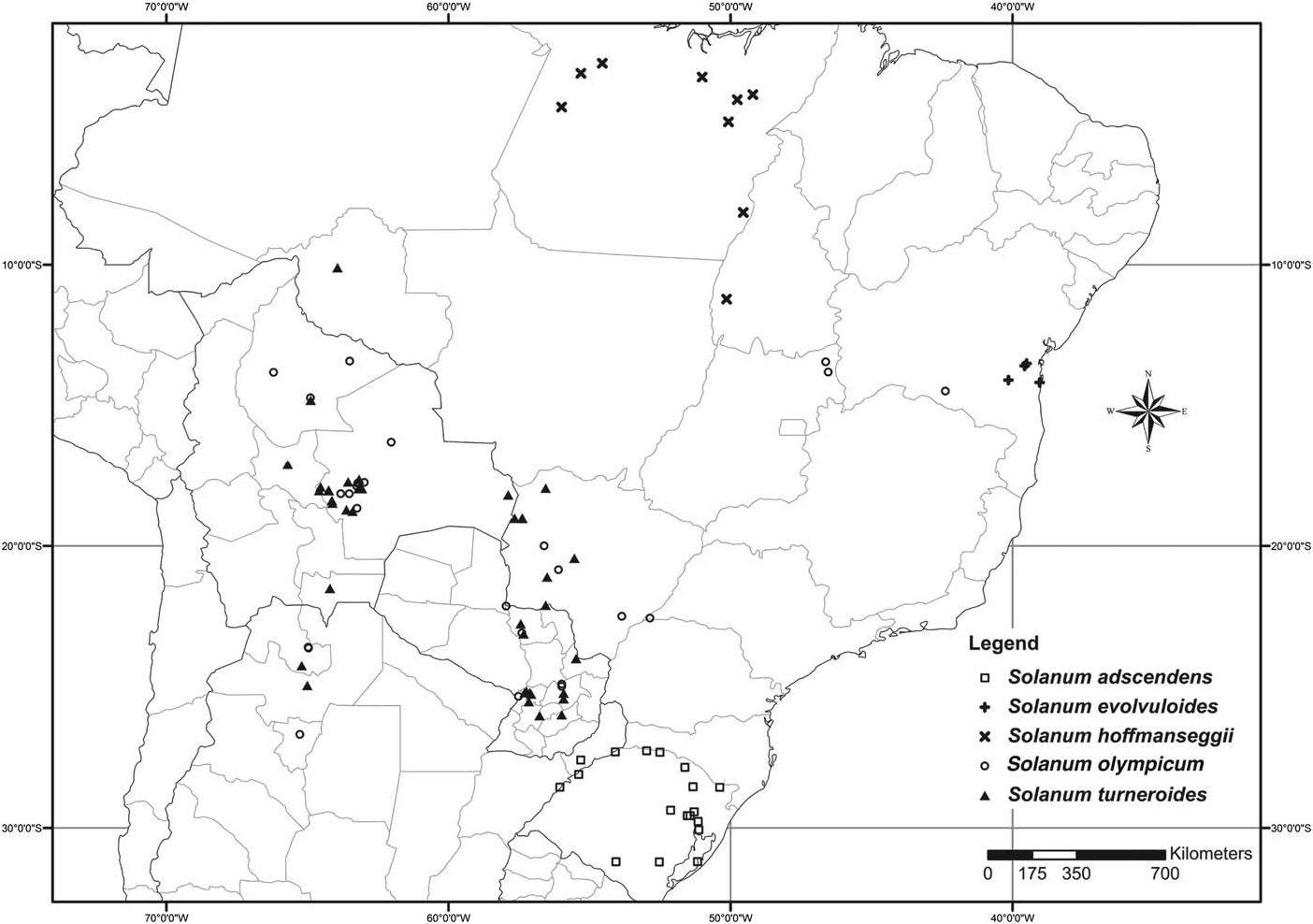
Habitat and Distribution— A weedy species of roadsides, grassy pastures, gallery forest, alluvial flats, forest edges, and open shrubby vegetation that occurs from central Bolivia to eastern Paraguay and the Brazilian state of Mato Grosso do Sul and south into northwestern Argentina between 300 –1,950 m in elevation ( Fig. 5 View FIG ).
Phenology— Flowering specimens have been collected in all months except August with a peak from October through February. Fruiting specimens have been collected in January through May and September through December.
Conservation Status— The widespread distribution and abundant populations of S. turneroides give it an IUCN Red List Status of Least Concern.
Etymology— The epithet turneroides presumably refers to a resemblance to the genus Turnera (Turneraceae), possibly due to the five-parted flowers that usually open in the morning and last for only a few hours. In the description, Chodat mistakenly likens the habit of S. turneroides to that of S. caripense Dunal , a viny member of Solanum sect. Basarthrum .
Additional Specimens Examined— BRAZIL. Mato Grossodo Sul: Mun. Corumbá, Morro Bocaina, 18 Oct 1991 (fl), Damasceno 178 (COR, UEC); Bairro Aeroporto, morro defronte ao aeroporto, rua Alan Kardec, 19 ° 01 ' S, 57 ° 39 ' W, 220 m, 25 Jan 2001 (fl) Gomes 39 (SPF); Mun. Bela Vista, 10 km W, 17 Mar 1985 (fl), Hatschbach & Zelma 49158 (MBM, NY); Mun. Aquidauana, Piraputanga, 4 Jun 1994 (fl), Hatschbach et al. 60696 (MBM, NY); Mun. Porto Murtinho, rodovia Bonito-Campo do Índios, Fazenda Água Doce, 10 Nov 2002 (fl, fr), Hatschbach 74004 (MBM); Mun. Bonito, Fazenda Nossa Senhora do Perpétuo Socorro, 12 Oct 2003 (fl, fr), G. Hatschbach et al. 76260 (CTES, MBM, NY); Mun. Porto Murtinho, rodovia Jadim-Porto Murtinho, BR-267, próximo do Rio Perdido, 250 m, 15 Mar 2004 (fl), Hatschbach 77410 (MBM); Mun. Corumbá, Jul 1911 (fl), Hoehne 3749 (R, US); Estrada para a Chácara São Marcos, Bairro entre Cristo Redentor e Cravo Vermelho, 19 ° 02 ' 16.8 '' S, 57 ° 37 ' 41.7 '' W, 29 Nov 2000 (fl, fr) Moraes 554 (UEC); Corumbá, Fazenda of Dr. Romeu, 19 ° 01 ' S, 57 ° 39 ' W, 20 Nov 1987 (fl), Ratter et al. 6043 (MO); 15 km from Corumbá, 29 Jan 1991 (fl) Ratter 6513 (CPAP, MBM); Mun. Corumbá, Morro de Azeite, 10 Apr 1992 (fr), Resente 667 (BHCB, CGMS); Corumbá, 18 Dec 1902 (fl, fr), Robert 721 (BM); Mun. Miranda, Salobra, Dec 1941 (fl) Santos s.n. (R 79588); Mun. Bela Vista, Rio Guaviral, 12 Nov 2006 (fl, fr), Silva et al. 5266 (MBM).
BOLIVIA. Beni: Prov. Cercado, campus of the Universidad Tecnica del Beni, 2.5 km Nof center of Trinidad, 14 ° 48 ' S, 64 ° 53 ' W, 200 m, 13 Dec 1988 (fl, fr), Nee 37160 (NY). Chuquisaca: Oropeza, ca. 5 km below Chuquichuqui in Río Chaco Valley, 1800 m, 19 Jan 1997 (fl, fr), Wood 11679 (K, LPB). Cochabamba: Río Caine, 1,180 m, Jan 1949 (fl, fr), Cárdenas 4098 (US). Santa Cruz: Prov. Nuflo de Chavez, Concepción, 500 m, 18 Feb 1995 (fr), Abbot 16233 (WU); Santa Cruz, 1200 ft, 23 Sep 1964 (fl, fr), Badcock 416 (K); Prov. A. Ibañez, ca. 15 km hacia el Nde Santa Cruz, por el Nuevo aeropuerto Viru Viru, 420 m, 19 Mar 1981 (fl, fr), Beck 6666 (M); Prov. Cordillera, Alto Parapetí, 800 m, 16 Jan 1980 (fl), de Michel 44 (NY); Prov. Caballero, Estancia Lanza-Lanza, 2 km del Río Comarapa sobre ladera con 30 ° de inclinación exposición W, 18 ° 02 ' 04 '' S, 64 ° 35 ' 00 '' W, 1600 m, 22 Jan 1995 (fl, fr), Gutiérrez et al. 1521 (NY); Prov. Andrés Ibáñez, 1 km Nfrom Pedro Lorenzo, 20 km along the Camiri highway, 9 May 2000 (fr), Kuroiwa &. Maeda 1596 (NY); Alto Parapetí, 850 m, 8 Jan 1982 (fl), Michel 98 (LPB); Prov. Andrés Ibáñez, along Río Pantano [=Río Chore-Chore], 7 km SE of Palmar del Oratorio and 18 km SE of center of Santa Cruz, 17 ° 56 ' S, 63 ° 06 ' W, 380 m, 9 Dec 1988 (fl, fr), Nee 37085 (LPB, TEX, NY, WIS); Prov. Andrés Ibáñez, 13 km SE of Palmar del Oratorio and 6 km SE of Rio Chore-Chore [= Río Pantano] 17 ° 58 ' S, 63 ° 04 ' W, 375m, 22 Jan 1989 (fl, fr), Nee 37668 (G, MO, NY); Prov. Andrés Ibáñez, NW side of “Valle Sanchez,” 4 km Wof Aeropuerto Internacional Viru-Viru, 15 km Nof Santa Cruz, 17 ° 38 ' S, 63 ° 10 ' W, 375 m, 26 Jan 1989 (fl, fr), Nee 37741 (NY); Prov. Caballero, Wside of Río Comarapa, 0.5 km Wof center of Comarapa, 17 ° 54 ' S, 64 ° 32 ' W, 1825 m, 12 Dec 1992 (fl), Nee 43093 (NY); Prov. Andrés Ibáñez, along highway from Santa Cruz to Abapó, 3 km Sof crossing of railroad and 2 km Sof bridge over Quebrada Peji, 17 ° 58 ' S, 63 ° 11 ' W 450 m, 25 Apr 1998 (fl, fr), Nee 49117 (CORD, G, NY); Prov. Vallegrande, 4 km SW of El Trigal on road to San Juan del Chaco, Sside of Río Ariruma, 19 km (by air) NNW of Vallegrande, 18 ° 29 ' S, 64 ° 07 ' W, 1950 m, 31 Jan 1987 (fl), Nee & Coimbra 33932 (NY); Prov. Vallegrande, 10 km (by air) NNW of Vallegrande, 18 ° 23 ' S, 64 ° 08 ' W, 1850 m, 1 Feb 1987 (fl, fr), Nee & Coimbra 33944 (G, NY, US); Prov. Florida, 7 km (by air), 10.2 km (by road) NNW of Mataral on road to San Juan del Potrero, 18 ° 02 ' 45 '' S, 64 ° 14 ' 25 '' W, 1475 m, 30 Jan 1994 (fl, fr), Nee & Vargas 44789 (NY); Prov. Andrés Ibáñez, along highway from Santa Cruz to Abapó, 3 km Sof crossing of railroad and 2 km Sof bridge over Quebrada Peji, 17 ° 58 ' S, 63 ° 11 ' W, 450 m, 27 Feb 1998 (fr, fl), Nee et al. 48485 (NY); Prov. Andrés Ibáñez, along highway from Santa Cruz to Abapó, 3 km Sof crossing of railroad and 2 km Sof bridge over Quebrada Peji, 17 ° 58 ' S, 63 ° 11 ' W, 450 m, 1 May 2001 (fl), Nee et al. 51716 (NY); Prov. Florida, 3 km (by air), 7 km (by road) NE of Mairana on road to Parque Nacional Amboró camp “Yunga de Mairana,” 18 ° 06 ' S, 63 ° 56 ' W, 1850 m, 28 Mar 2002 (fl, fr), Nee et al. 52003 (NY); Prov. Cordillera, Cabezas, 420 m, 19 Feb 1945 (fl), Pareolo 253 (A, NY); Prov. Cordillera, Cabezas, 420 m, 18 Mar 1945 (fl, fr), Pareolo 444 (NY); Serranias de Chiquitos, camino a Tucavaca 2 Feb 2005 (bs), Solis Neffa 1790 (BHCB, CTES); Prov. Sara, “Arenales del Gwenda” [sandy areas in savanna of Río Guendá, now forming border of Prov. Ichilo and Prov. Andrés Ibáñez, M. Nee 2001] 450 m, 8 May 1921 (fl, fr), Steinbach 5625 (GH, NY); Prov. Sara, Arenales, Río Perdix, 400 m, 23 Oct 1924 (fl), Steinbach 6627 (G, GH, K); Prov. Sara, Río Perdix, 400 m, 29 Dec 1925 (fl), Steinbach 7367 (F, G, GH, MO); Prov. Chiquitos, Cerro Mutún, 7 km al NE de la pista de aterrizaje del campamento minero (25 km al Sde Puerto Suárez), 18 ° 11.3 ' S, 57 ° 52.7 ' W, 750 m, 17 – 20 Oct 1994 (fl), Vargas et al. 3328 (CTES, NY, USZ); ca. 4 km Eof San Isidro (Palizada) on road to Mataral, 18 ° 2 ' S, 64 ° 25 ' W, 1400 m, 3 Jan 2000 (fl), Wood 15770 (LPB). Tarija: Prov. Gran Chaco, 5– 5.7 km Wof the center of Villa Montes on road to Entre Ríos and Tarija (not the new segment under construction now), 0 – 0.7 km toward Villa Montes from the highway bridge over the Río Pilcomayo, 21 ° 15 ' 28 '' S, 63 ° 30 ' 40 '' W, 400 m, 9 Feb 2006 (fr), Nee & Linneo 54034 (G); Gran Chaco, San Francisco de Inti, camino de Yacuiba a Villa Montes, a 22 km Nde la rotonda de Yacuiba, 21 ° 48 ' 56 '' S, 63 ° 35 ' 05 '' W, 586 m, 16 Jan 2004 (fl), Neffa et al. 989 (CTES, G); Prov. O’Connor, hills north of Entre Rios, 1400 m, 6 Feb 1937 (fl, fr), West 8254 (GH, MO, UC).
PARAGUAY. Alto Paraguay: Chaco, linea 3 (Oeste), km 50 [19 ° 42 ' S, 61 ° 18 ' W], 44 km al Ede la pista de aviación de Cabrera (19 ° 42 ' S, 61 ° 19 ' W), 9 Nov 1992 (fl), Ramella et al. LR2924 (G). Amambay: Ruta 3 y Río Aquidabán, 23 Dec 1980 (fr), Schinini & Bordas 25042 (G). Caaguazú: cerca y al Nde Yhú, 21 Feb 1982 (fl, fr), Fernández Casas FC6384 (G, MO); cerca y al Sde Yhú, 24, Sep 1980 (fl), Fernández Casas FC3910 (NY); unos 5 km al Nde Yhú, en una zona inundable en mayor o menor grado, 320 m, 12 Dec 1982 (fl, fr), Fernández Casas & Schinini 7460 (MO, NY); 15 km al Nde Caaguazú, camino a Yhú, 8 Feb 1966 (fl, fr), Krapovickas et al. 12568 (US); 10–15 km Nof Caaguazú, 19 Feb 1994 (fl, fr), Pedersen 16075 (G); Arroyo Cambay, 22 ° 25 ' S, 55 ° 55 ' W, 10 Nov 1990 (fl, fr), Zardini & Velázquez 23807 (MO); Arroyo Yuquyry-Arroyo Taruma, 4 km Nof Arroyo Yuquyry, 25 ° 13 ' S, 55 ° 55 ' W, 12 Jan 1991 (sterile), Zardini & Velázquez 25858 (MO). Canendiyú: Nandurocai, Reserva Natural de Bosque Mbaracayú, 13 km Sde Ipé-hú, 3 Dec 1997 (fl, fr), Schinini 33262 (CTES); Mbaracayú Natural Reserve, administered by Fundación Moisés Bertoni, around Ñandurokai, 23 ° 59 ' 39 '' S, 55 ° 28 ' 44 '' W, 27 May 1999 (fl), Zardini & Chaparro 50809 (NY). Concepción: Estancia Ñu Apua, 110 km Nof Concepción, a 1500 m Wde la Adm., 19 Mar 1991 (fl), Eliceche 44 (MO); Paso Horqueta, Río Aquidabán, 41 km Nde Concepción, 140 m, 17 Dec 1983 (fl, fr), Vanni et al. 377 (G, NY); Estancia Bello Horizonte, Arroyo Tagatiyá-Guazú, 22 ° 45 ' 40 '' S, 57 ° 26 ' 15 '' W, 13 Oct 1994 (fr), Zardini & Guerrero 41286 (NY); Paso Horqueta, Río Aquidaban, 20 ° 07 ' S, 57 ° 20 ' W, 18 Nov 1993 (fr), Zardini & Tilleria 37468 (G, MO, NY). Cordillera: Salto Piraretá, 25 ° 30 ' S, 56 ° 55 ' W, 18 Oct 1994 (fl, fr), Krapovickas et al. 45675 (G); 4 km SE of Emboscada on road to Nueva Colombia, 25 ° 09 ' S, 57 ° 14 ' W, 18 Nov 1991, (fl, fr), Zardini & Tillería 28888 (MO); Tobatí “Ybytú Silla” mesa, southern area, 25 ° 12 ' S, 57 ° 07 ' W, 297 m, 3 Mar 1991 (fr), Zardini & Velázquez 26963 (MO). Paraguari: Piraretá, 14 Nov 1969 (fl, fr), Pedersen s.n. (CTES 315405); National Park Ybycu’í, Northeastern area, 26 ° 01 ' S, 56 ° 46 ' W, 12 Mar 1992 (fr), Zardini & Guerrero 31042 (G, MO, NY); Tucangua, Cordillera de Altos, 25 ° 31 ' S, 57 ° 09 ' W, 9 Dec 1943, (fr), Rojas 10731 (MO). Without Dept.: N Paraguay, zwischen Rio Apa und Rio Aquidaban, 1908/1909 (fl, fr), Fiebrig 4408 = 4827 (BM, G, GH); Paraguay, 1885–1895 (fl), Hassler 1010 (G); in arenosis pr. Hacurubi, Dec 1885– 1895 (fl), Hassler 1585 (G); Sapucay, Dec 1885– 1895 (fl), Hassler 1638 (G); in silva pr. Cordillera de Altos, Jan 1885– 1895 (fl), Hassler 1737 (G); in arenosis pr. Estero Troxler, Jan 1885 – 1895 (fl), Hassler 1793 (G); Paraguaria Centralis, in campo “Intacurabi,” Jan 1900 (fl), Hassler 3801 (BM, G, GH, NY); “Yerbales” montium “Sierra de Maracayú,” in regione fluminis Tapiraguay, Aug (fl, fr), Hassler 4293 (G); Paraguay, (fl, fr), Hassler 4396 (UC); Inter ad “Yerbales” montium “Sierra de Maracayú”, in regione vicine “Igatimí,” Oct 1898–1899 (fl, fr), Hassler 4841 (G); Cerros de Tobaty, (fl), Hassler 8069 (G, GH, MO, NY, S, UC, US); in regione lacus Ypacaray, Jan 1913 (fl, fr), Hassler 12141a (G); Paraguaria Centralis, in regione lacus Ypacaray, Apr 1913 (fl), Hassler 12441 (BM, G, GH, K, MO, NY, S, UC, US).
ARGENTINA. Jujuy: Dept. Capital, Alto La Viña, ruta 56, 4 km al NE de Jujuy, 1250–1300 m, 29 Dec 1989 (fr), Novara 9287 (G). Salta: Dept. Capital, Chachapoyas, Sierra de Vélez, cerros al Ede la Univers. Católica, 1200 m, 30 Jan 1987 (fl), Novara 5884 (G); same locality and date, Novara 5919 (G).
Notes— Strongly heterantherous flowers are only found in two members of the section, S. turneroides and S. evolvuloides . Solanum turneroides can be distinguished from S. evolvuloides by its lack of glandular hairs, its larger flowers, and its more widespread South American distribution. As noted by Nee (1989), the flowers of S. turneroides are not open in the heat of the day, as is also the case for S. evolvuloides (L. Giacomin, pers. obs.). When grown in the greenhouse at UT the flowers were open and very fragrant during the night and early morning. As the day gets warmer the flowers take on a wilted appearance. The pollinators of these flowers are unclear. Fragrance is unusual in the genus and is commonly only found in S. sect. Pachyphylla ( Bohs 1994) . The floral development is also of interest, with the stamens of equal length on the first day the flower is open and then the filament of the lowermost anther doubling in length the following day ( Figs. 13C, D View FIG ).
Although herbarium sheets rarely display the feature, S. turneroides seems to spread rhizomatously. The hairs of S. turneroides are also unique in the section. While they superficially appear to be geniculate, like those of S. olympicum and S. hoffmanseggii , closer inspection shows that the hairs are simply bent downward on the stem and lack the 90 ° elbow bend that characterizes the hairs of the latter two species. Using scanning electron microscopy, the base of these hairs appears to have a ring of small lateral cells, hinting that perhaps these hairs are reduced stellate hairs. If so, it may suggest that the simple hairs found in this and other species of sect. Gonatotrichum may represent evolutionary reductions from stellate hairs.
The protologue of S. turneroides cites many Hassler specimens as syntypes, all from Paraguay, but gives no herbarium locations. Hassler 4396 has been chosen from among the many syntypes cited because of the quality of the collection and its wide distribution in herbaria. The sheet from the Hassler herbarium at Gis chosen as the lectotype.
Bitter cited four syntypes in his protologue for S. gonatotrichum , including Fiebrig 2732 and three un-numbered specimens collected in Salta, Argentina by Hieronymus & Lorentz, all from Berlin and destroyed. Aduplicate specimen of the only numbered syntype, Fiebrig 2732, is at Munich and we have designated this as the lectotype because of the quality of the material and widespread photographs of the specimen.
Bitter’s protologue of S. geniculatistrigosum cited only a single specimen from B, the holotype, which was destroyed in 1942. Photos of this sheet remain at F, G, GH and WIS; a duplicate at BM has been designated the lectotype and isolectotypes have been seen at LE and P.
Bitter also cited only one specimen of S. flavistrigosum at S, making it the holotype. The only unusual aspect of this is that Bitter describes the flowers in detail, but the specimen only has buds.
No known copyright restrictions apply. See Agosti, D., Egloff, W., 2009. Taxonomic information exchange and copyright: the Plazi approach. BMC Research Notes 2009, 2:53 for further explanation.
|
Kingdom |
|
|
Phylum |
|
|
Class |
|
|
Order |
|
|
Family |
|
|
Genus |
Solanum turneroides
| Stern, Stephen, Bohs, Lynn, Giacomin, Leandro, Stehmann, João & Knapp, Sandra 2013 |
Solanum flavistrigosum
| Bitter 1913: 74 |
Solanum gonatotrichum
| Bitter 1912: 230 |
Solanum geniculatistrigosum
| Bitter 1912: 232 |