
Solanum crassinervium, Tepe,
|
publication ID |
https://doi.org/ 10.1600/036364411X605074 |
|
DOI |
https://doi.org/10.5281/zenodo.6329691 |
|
persistent identifier |
https://treatment.plazi.org/id/03BC87C5-FFE7-8239-FF7D-F8B75E8997DE |
|
treatment provided by |
Tatiana |
|
scientific name |
Solanum crassinervium |
| status |
|
1. SOLANUM CRASSINERVIUM Tepe, View in CoL
J. Bot. Res. Inst. Texas 3: 514. 2009.
—TYPE: ECUADOR. Carchi / Esmeraldas: near Lita , 600 m, wet evergreen forest, 19 May 1987 (fl, fr), H. H. van der Werff 9496 (holotype: QCNE–8516 !; isotypes: MO–4299600 !, NY–NY00735823 !).
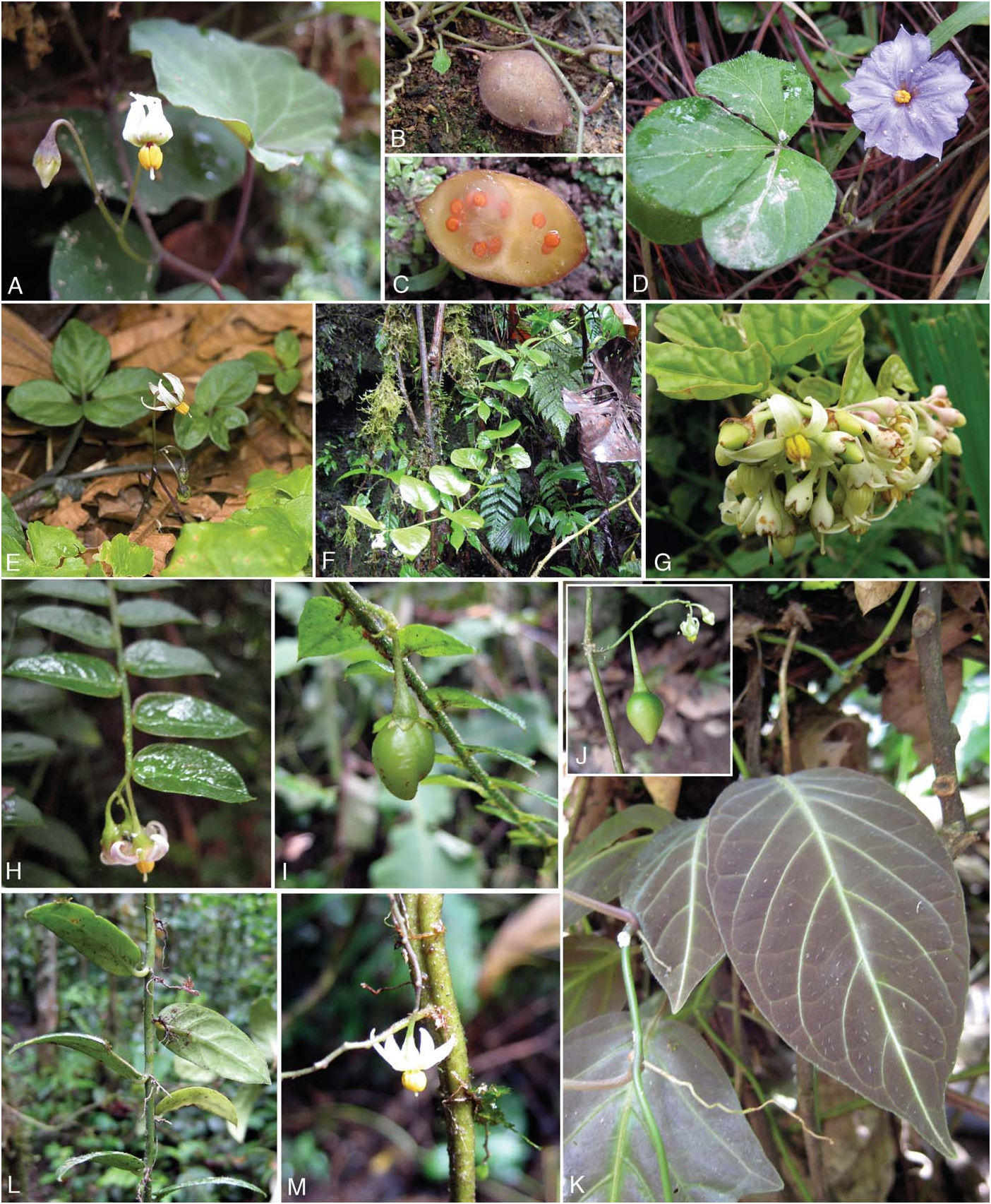
Vine or scandent shrub, climbing understory trees to 4 m or more; leafy branches spreading to pendulous. Stems thickly herbaceous to weakly woody, somewhat fleshy, glabrous to sparsely pubescent and soon glabrescent. Sympodial units plurifoliate to rarely unifoliate. Leaves simple, the blades 3.5–14 × 1.5–8 cm, 1–2 times as long as wide, gradually reduced in size toward the inflorescence, ovate to elliptic, somewhat fleshy, sand-punctate, glabrous adaxially and abaxially or rarely with fine pubescence on the midvein adaxially; venation pinnate, with 5–7 pairsofsecondaryveins, these conspicuous and prominent abaxially, densely sand-punctate; base rounded to truncate to cordate, sometimes oblique; margins entire; apex shortly acuminate; petioles (0.2–) 1–1.5 cm, glabrous or rarely pubescent adaxially, densely white sandpunctate. Internodes 1.5–5.5 cm. Inflorescences 1–3 cmlong in flower to ca. 6 cm in fruit, unbranched to branched, stemterminal to axillary to extra-axillary, with 2–16 flowers (scars), the axes glabrous; peduncle 0.1–0.5 cm; rachis 0.1–2 cm; pedicels 4–12 mm in flower, 9–18 mm in fruit, only slightly enlarged distally, glabrous to rarely sparsely pubescent, spaced nearly contiguously. Calyx 2.5–3.5 mm long, glabrous, themargins thickened, the tube 2.5–3 mm long, the lobes 1.5–2.5 × 1.5–2 mm, deltoid, acute to acuminate at tips, white to pale pink; fruiting calyx somewhat accrescent, the lobes 1.5–2.5 × 1.5–2.5 mm. Corolla 1.5–2 cmindiameter, 5–8 mm long, stellate, somewhat fleshy, white, the lobes 5–8 × 2.5–3 mm, planar at anthesis, acute to acuminate at apices, glabrous adaxially, sparsely pubescent near the apex abaxially, the margins densely ciliate. Stamens with filaments 1–1.5 mm long, glabrous; anthers 3–4 × 1.2–1.5 mm. Ovary glabrous; style 4–6 × ca. 0.3 mm, glabrous, cylindrical, sometimes deflected to one side of flower; stigma capitate. Fruit (immature) 0.7–1 × 0.7– 0.9 cm, ovoid to nearly globose, slightly flattened, somewhat pointed at apex, green to pale orangish to brownish at maturity, glabrous. Seeds 2–2.2 × 1.8–2 mm, flattened-reniform, tan, the surface minutely reticulate-rugulose. Figure 1F–G View FIG .
Habitat and Distribution— Solanum crassinervium occurs west of the Andes in southwestern Colombia and northwestern Ecuador in lowland and premontane rainforest habitats, including the Mache-Chindul mountain range in northwestern Ecuador; 150–600(–1,800) m in elevation ( Fig. 5 View FIG ).
Phenology— Flowering apparently occurs year-round; fruiting specimens have been collected from Jan.–Feb., and Sept.–Dec.
Conservation Status— According to the IUCN red list categories ( IUCN 2010), S. crassinervium is classified as B1a+biii (endangered). This species is restricted to rainforest habitats in northwestern Ecuador and extreme southwestern Colombia, covering an area estimated to be considerably less than 5,000 km 2. This area is one of the more inaccessible parts of Ecuador, but increasing exploitation of this area continues to decrease the amount of suitable habitat for S. crassinervium (C. Aulestia, Bilsa Biological Station, pers. comm.).
Etymology— The epithet crassinervium describes the prominent secondary veins that are useful in helping distinguish this species from its closest relatives.
Notes— Solanum crassinervium is one of the climbing species, and can be distinguished from the other species in the section by the somewhat fleshy texture of the stems, leaves, and flowers, its ovate to elliptical leaves with conspicuous secondary veins that are visible in fresh and dried material, and its occasionally branched inflorescences. This is the most robust species of sect. Herpystichum .
Solanum crassinervium is most similar to S. evolvulifolium and S. loxophyllum , but differs from both species in its robust habit, broadly ovate leaves (vs. mostly oblong), fleshy calyx and corolla, and inflorescences that may be simple and branched on the same individual. It can be easily differentiated from S. evolvulifolium by its much larger leaves, petioles, and internodes. The leaves of both S. crassinervium and S. loxophyllum are somewhat fleshy, and both species tend to dry dark to nearly black; however, S. crassinervium has more secondary veins (5–7 vs. 3–4 pairs) and these are prominent abaxially, whereas those of S. loxophyllum are often obscure within the fleshy leaf blade (translucent in living material and flush with the leaf surface in dried material). The often stout and branched inflorescences of S. crassinervium differ from those of S. loxophyllum , which are apparently always simple, and are slender and delicate. Furthermore, inflorescences of S. crassinervium are typically produced in the leafy part of the stem, as compared to those of S. loxophyllum , which are typically borne on older, leafless parts of the stem.
Additional Specimens Examined— COLOMBIA. Nariño: 1,000 m, 9 May 1939 (fl), A. H. G. Alston 8547 ( BM); Trayecto Pialapi – La Planada, 1°10’N 77°58’W, 1,300 –1,700 m, 23 Jul 1988 (fr), O. de Benavides 10150 ( MO); Mpio. Barbacoas, Corregimiento Altaquer, Vereda El Barro, Reserva Natural Río Ñambí, margen derecha del Río Ñambí, 1°18’N 78°08’W, 1,325 m, 1 Dec 1993 (fl), P. Franco et al. 4707 (COL, NY); Mpio. Tumaco, Resguardo de Albí, lado izquierdo del Río Albí, 1°22’N 78°28’W, 220– 280 m, 12 Nov 1995 (fl, fr), B. R. Ramírez et al. 8826 ( NY); Mpio. Barbacoas, Resguardo Indígena de Saundé, 1°30’N, 78°20’W, 350 m, 21 Jan 1996 (fr), B. R. Ramírez et al. 9699 ( NY).
ECUADOR. Carchí: Río Blanco drainage above Chical, ca. 12 km Wof Maldonado, 1,300 –1,500 m, 25 Sep 1979 (fl), A. Gentry & G. Schupp 26522 ( MO); Cantón Tulcán, Parroquia Tobar Donoso, Reserva Indígena Awá, Centro El Baboso, 0°53’N 78°25’W, 1,800 m, 17–27 Aug 1992 (fr), G. Tipaz et al. 1802 ( MO); Cantón Tulcán, Parroquia Tobar Donoso, Reserva Indígena Awá, Centro El Baboso, 0°53’N 78°25’W, 1,800 m, 17–27 Aug 1992 (fr), G. Tipaz et al. 1813 (BM, NY, QCNE); border area between Prov. Carchi and Esmeraldas, 20 km past Lita on road Lita-Alto Tambo, 550 m, 25 Jun 1991 (fl), H. van der Werff et al. 11972 (MO, NY, QCNE). Esmeraldas: Bilsa Biological Station, Montañas de Mache, 20 km NW of Quinindé, 3 km W of Santa Isabel, 0°22’N 79°45’W, 600 m, 26 Sep 1994 (fr), J. R. Abbott 15256 (MO, SEL); San Lorenzo, Reserva Étnica Awá, Parroquia Alto Tambo, Centro de la Union, Cañon del Río Mira, 0°52’N 78°26’W, 250 m, 22 Mar 1993 (fl), C. Aulestia & M. Aulestia 1431 (MO, QCNE); Cantón Quinindé, Bilsa Biological Station, Montañas de Mache, 35 km Wof Quinindé, 5 km W of Santa Isabel, reserve boundary Nfrom Station road, between the Río Cube tributary and the E-bearing boundary crossing the Río Cube, 0°21’N 79°44’W, 400–600 m, 26 Sep 1994 (fr), M. S. Bass & N. Pitman 68 (BM, NY); Bilsa Biological Station, Montañas de Mache, 35 km Wof Quinindé, 5 km Wof Santa Isabel, 0°21’N 79°44’W, 400–600 m, 6 Dec 1994 (fl), M. S. Bass & N. Pitman 289 ( MO); San José, km 321 along railroad from Ibarra to San Lorenzo, 1°N 78°W, 350 m, 5 May 1982 (fl), B. M. Boom 1374 (F, NY, QCA); Cantón Quinindé, Bilsa Biological Station, Montañas de Mache, 35 km Wof Quinindé, 5 km Wof Santa Isabel, Monkey Bone Trail, 0°21’N 79°44’W, 400–600 m, 15 Sep 1994 (fr), J. L. Clark & B. Adnepos 55 (MO, QCNE); Cantón Quinindé, Bilsa Biological Station, Mache Mountains, 35 km Wof Quinindé, 5 km Wof Santa Isabel, 0°21’N 79°44’W, 400–600 m, 24 Jan 1995 (fl), J. L. Clark 412 (BM, NY, QCNE); Cantón Quinindé, Bilsa Biological Station, Mache Mountains, 35 km Wof Quinindé, 5 km Wof Santa Isabel, 0°21’N 79°44’W, 500 m, 18 Feb 1996 (fr), J. L. Clark 2121 (BM, NY, QCNE, US); Cantón Quinindé, Mache-Chindul Ecological Reserve, Bilsa Biological Station, Mache Mountains, 35 km Wof Quinindé, 0°21’N 79°44’W, 500 m, 1–10 Jan 1997 (fr), J. L. Clark 2993 (MO, US); Cantón Quinindé, Mache-Chindul Ecological Reserve, Bilsa Biological Station, Mache Mountains, 35 km Wof Quinindé, 0°21’N 79°44’W, 500 m, 1–10 Jan 1997 (fr), J. L. Clark et al. 3762 (MO, NY, QCNE, US); 10 km Wof Lita on road to San Lorenzo, 0°55’N 78°30’W, 800 m, 12 May 1991 (fl), A. Gentry et al. 69984 (GOET, MO, NY); Cantón San Lorenzo, Lita to El Cristal road, finca of Dr. La Lama, 13.5 km Sof Lita, 0°49’N 78°26’W, 1,220 –1,350 m, 2 Nov 1992 (fl, fr), J. L. Luteyn et al. 14744 (MO, NY, QCA, US); Cantón Quinindé, carretera Herrera-El Páramo (Sta. Isabel), Estación Biológica Bilsa, 0°1’36.7”N 79°42′40.4″W, 580 m, 18 Feb-5 Mar 1995 (fr), W. Palacios et al. 13548 (MO, NY, QCNE); Cantón Quinindé, carretera Herrera-El Páramo (Sta. Isabel), suroeste de la casa de la Estación Biológica Bilsa, 0°1’36.7”N 79°42′40.4″W, 580 m, 2–4 Mar 1995 (fl), W. Palacios et al. 13719 ( MO); Cantón Quinindé, Bilsa Biological Station, Montañas de Mache, 35 km Wof Quinindé, 5 km Wof Santa Isabela, Monkey Bone trail, 0°21’N 79°44’W, 400–600 m, 11 Dec 1994 (fl, fr), N. Pitman & M. Bass 1091 (MO, NY, QCNE); San Lorenzo, Territorio Awá, centro Mataje, 1°11’44”N 78°34′29″W, 200 m, 17 Nov 2000 (fl), W. Ramírez et al. 12 ( NY), 15 ( NY); Bilsa Biological Station, 5 km Wof Sta. Isabel, 0°20’49”N 79°42′41″W, 540 m, 14 Feb 2009 (fl, fr), S. Stern 400 (QCNE, UT); Bilsa Biological Station, 5 km Wof Sta. Isabel, 0°20’49”N 79°42′41″W, 540 m, 13 Feb 2009 (fl, fr), E. J. Tepe & S. Stern 2729 (BM, MU, NY, QCA, QCNE, UT); Eloy Alfaro, Reserva Ecológica Cotacachi-Cayapas, Parroquia Luis Vargas Torres, Río Santiago, Estero Angostura, 0°49’S 78°45’W, 250 m, 28 Oct 1993 (fr), M. Tirado et al. 628 ( MO); Eloy Alfaro, Reserva Ecológica Cotacachi- Cayapas, Parroquia Luis Vargas Torres, Río Santiago, Estero Angostura, 0°49’S 78°45’W, 250 m, 8–14 Dec 1993 (fr), M. Tirado et al. 775 ( MO).

| BM |
Bristol Museum |
| MO |
Missouri Botanical Garden |
| NY |
William and Lynda Steere Herbarium of the New York Botanical Garden |
| Wof |
Naturhistorisches Museum Wien |
| QCNE |
Museo Ecuatoriano de Ciencias Naturales |
| W |
Naturhistorisches Museum Wien |
| SEL |
Marie Selby Botanical Gardens |
| QCA |
Pontificia Universidad Católica del Ecuador |
| UT |
University of Tehran |
No known copyright restrictions apply. See Agosti, D., Egloff, W., 2009. Taxonomic information exchange and copyright: the Plazi approach. BMC Research Notes 2009, 2:53 for further explanation.