
Gryllus saxatilis Weissman & Gray, 2019
|
publication ID |
https://doi.org/ 10.11646/zootaxa.4705.1.1 |
|
publication LSID |
lsid:zoobank.org:pub:F534C43A-AB09-4CB3-9B08-FD5BDFD90298 |
|
persistent identifier |
https://treatment.plazi.org/id/182387A8-0989-FF67-51F6-FA23021BFBE5 |
|
treatment provided by |
Plazi |
|
scientific name |
Gryllus saxatilis Weissman & Gray |
| status |
sp. nov. |
Gryllus saxatilis Weissman & Gray , n. sp.
Western Rock-Loving Field Cricket
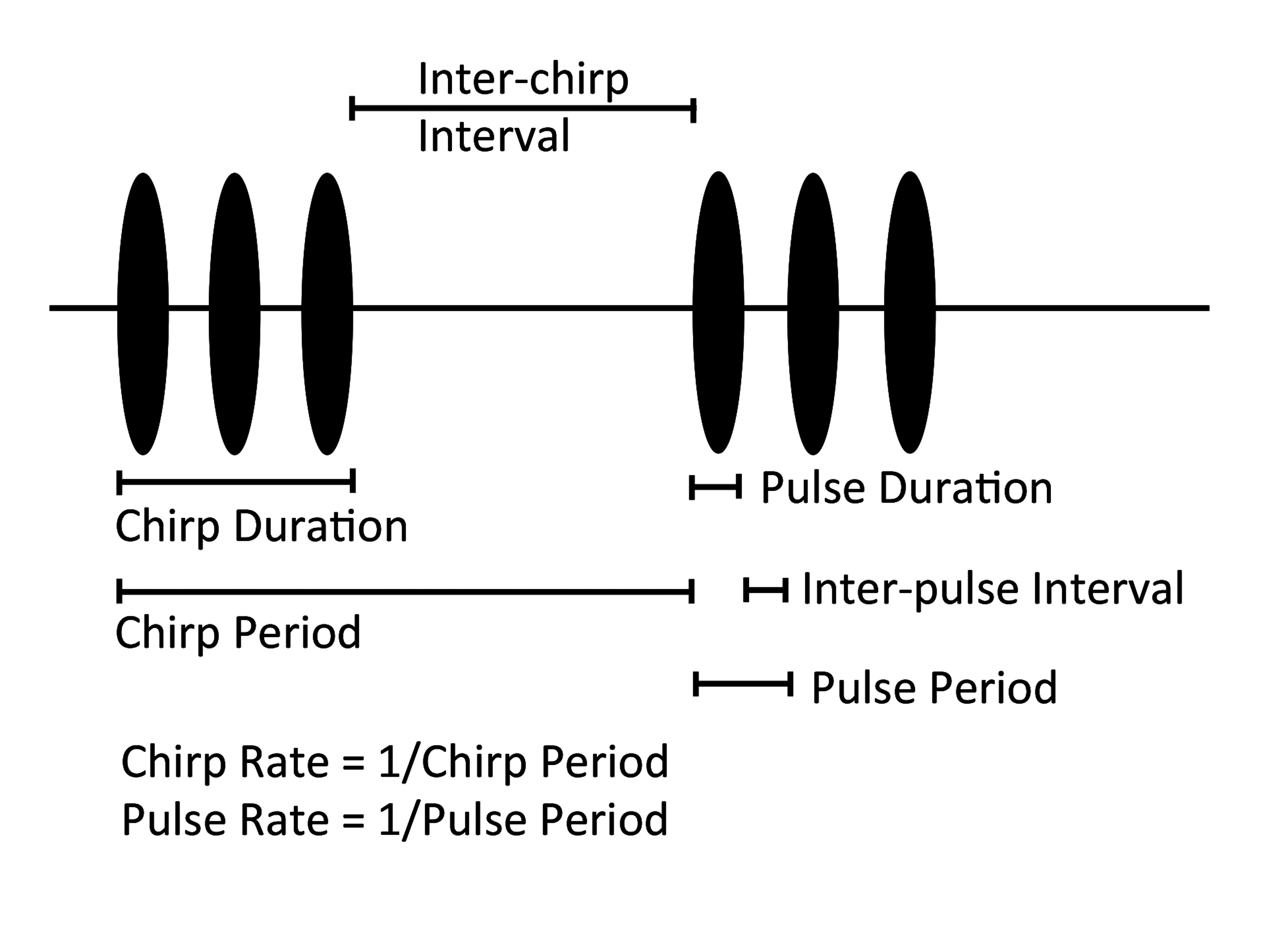
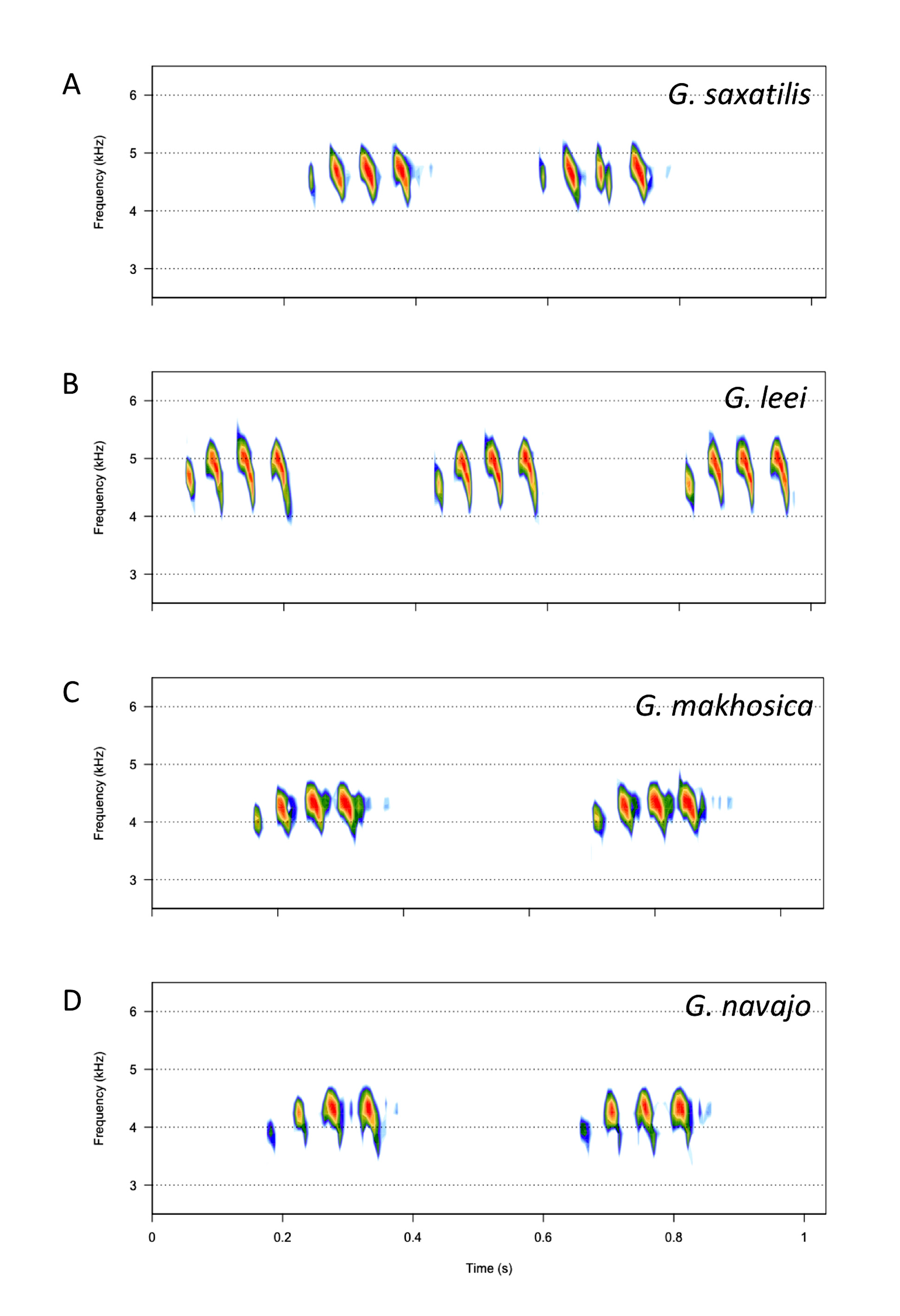
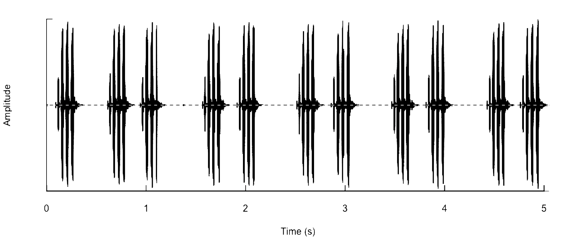
Figs 205 View FIGURE 205 , 236–246 View FIGURE 236 View FIGURE 237 View FIGURE 238 View FIGURE 239 View FIGURE 240 View FIGURE 241 View FIGURE 242 View FIGURE 243 View FIGURE 244 View FIGURE 245 View FIGURE 246 , 248 View FIGURE 248 , Table 1 View TABLE 1
Gryllus pennsylvanicus of Weissman et al., 1980.
‘ Gryllus #2’ of Rentz & Weissman, 1981.
‘G. #2, #11, #22, #38’, ‘G. mojave’, ‘G. tulare’, ‘G. mormoni’ of DBW notebooks.
Distribution. Widespread in the western US, west of the Rocky Mountains.
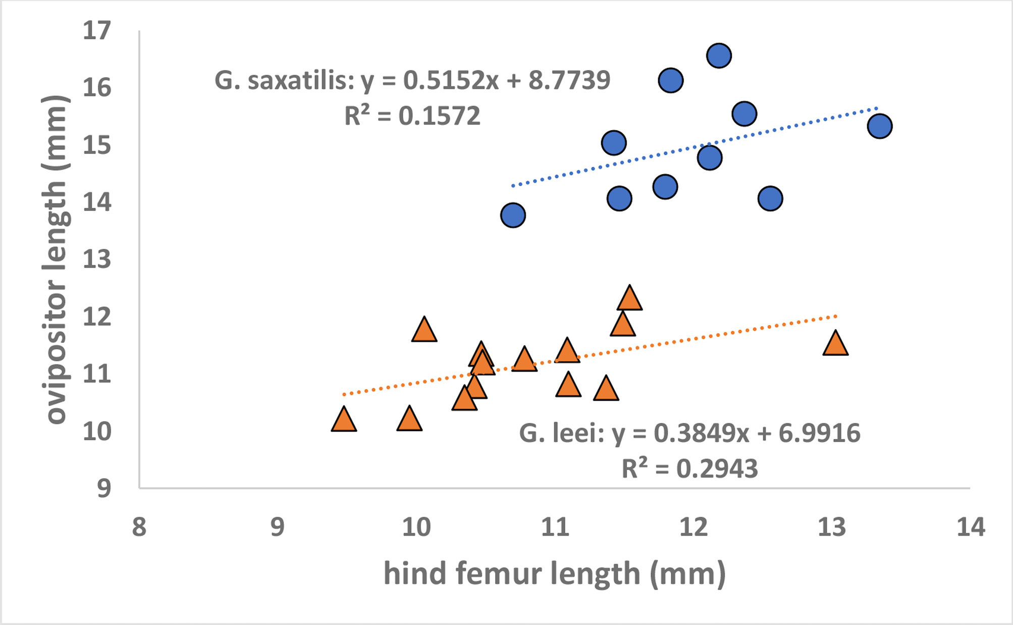
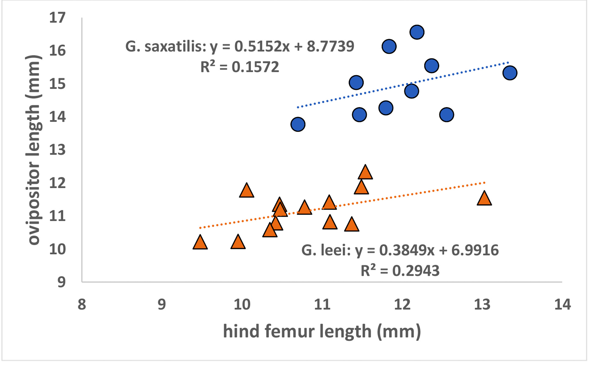
Recognition characters and song. A small to large, short or long hind winged, medium-long cerci rarely longer than ovipositor in situ, slow chirping cricket usually associated with rocky habitats. Song ( Fig. 239 View FIGURE 239 , R 15 View FIGURE 15 -372) with 3–5 p/c (range 2–7), 50–280 c/m, PR 14-25. Separated from the following western slow chirping Gryllus as follows: From G. longicercus , which has a distinctive, non-overlapping lower PR, and has more file teeth, longer cerci, and different DNA. From G. lightfooti which has a tegminal bar in females, shorter male tegmina, not usually associated with rocks, faster chirp rate, fewer file teeth, and different DNA. From G. montis which occurs at higher elevations under forest canopy and has different DNA. From G. navajo of red rock sandstone badlands in Utah and Arizona, the latter usually reddish in color with very long antennae in some populations reaching past tip of abdomen (e.g. Coconino Co., AZ, S07-56), cerci always longer than hind femur and, in certain populations, usually longer than ovipositor tip in situ. From Utah lava restricted G. leei , which are smaller crickets with shorter tegmina and longer cerci that always extend beyond the tip of the ovipositor, a rare situation in G. saxatilis . Ovipositor ~ 4–5 mm longer in G. saxatilis than in G. leei even when controlling for body size by regressing against hind femur length ( Fig. 240 View FIGURE 240 ; F 1 View FIGURE 1 , 21 View FIGURE 21 = 84.8. P<0.001; N = 14 G. leei ; N = 10 G. saxatilis ).
From South Dakota Badlands National Park G. makhosica which has long antennae extending well past tip of ovipositor and cerci longer than ovipositor in situ. The nearest population of G. saxatilis is ~ 580 km to the west near Cody, WY, where the latter lives in rocky areas and seldom climbs more than a meter vs. the deep cracks in clay badlands, up to 10 m above the canyon floor, that G. makhosica frequently inhabits.
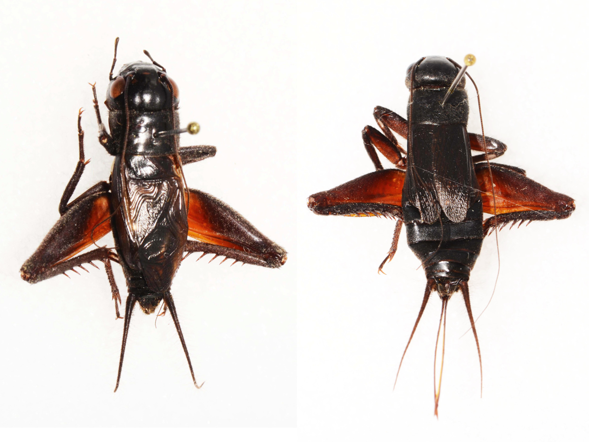
Holotype. Male ( Fig. 241 View FIGURE 241 ). California, Santa Clara Co., Mt. Hamilton, observatory area, 4040’, 7-vi-2009, 37° 20.384’ -121° 38.632’, D.B. Weissman. S09-43, R09-46, G1328. 16 S GenBank accession # MK 446492 View Materials ; ITS 2 Gen- Bank accession # MK 441923 View Materials . BL 23.74, HF 13.45, LC 14.57. Right tegmen removed: 174 teeth, FL 4.5, TL 15.1, TW 5.7. Type deposited in CAS, Entomology type #19272.
Paratypes. (Total 776♂ 300♀) CANADA. British Columbia, Haynes Ecological Reserve Hwy 97 3 m N Osoyoos , 1200’, 26-viii-2000 (S00-27) 5♂ 7♀ ; 19-vi-2004 (S04-62) 4♂ 8♀ . USA. Arizona. Coconino Co., Lees Ferry , 19-v-1987 (S87-35) 4♂ . Mohave Co., Kingman , 3700’, 2-viii-1992 (S92-113) 9♂ 25♀ . Hualapai Mt. Road 1.8 m NW Hualapai Mt. Rec. Area , 5850’, 16-vi-2007 (S07-64) 1♂ . Quartzsite , 1000’, 26-vi-1980 (S80-46) 2♂ 1♀ . California. Calaveras Co., Hwy 26 3.3 m SW West Point , 14-v- 2005, 740m (S05-51) 1♂ . Colusa Co., Hwy 20 at mile post 10.9, 547’ 5-viii-2014 (S14-61) 2♂. Contra Costa Co., Mt Diablo State Park , 3800’, 13-vii-1982 (S82-37) 4♂ ; 13-viii-1994 (S94-96) 2♂ ; 17-viii-1996 (S96-78) 2♂. Fresno Co., Jacalitos Canyon , 840-1020’, 29-viii-1981 (S81-76) 1♂ ; 9-iii-1982 (S82-2) 1♂ ; 6-iii-1992 (S92-33) 1♂; 3-vi-1997 (S97-54) 6♂ 1♀; 29-viii-1998 (S98-83, 84, 85) 8♂ 1♀; 18-viii-2001 (S01-97, 98, 99, 100) 19♂ 2♀; 4-v-2003 (S03-31 & 32) 2♂. Inyo Co. , Alabama Hills W Lone Pine , 4240’, 8-x-1995 (S95-110) 1♂ . Big Pine , 4000’, 8-x-1995 (S95-112) 3♂ 1♀ ; 27-vi-2017 (S16-18) 4♂ 4♀ . Bishop , 4150’, 16-iii-1996 (S96-13) 1♂ ; 28-viii-2005 (S05-99) 1♂ 7♀ . Death Valley National Monument, Furnace Creek , -186’, 5-vi-1983 (S83-60) 2♂ ; 25-vi-1992 (S92-61) 2♂ . Stovepipe Wells , 5’, 5-vi-1983 (S83-59) 1♂ ; 25-vi-1992 (S92-62) 2♀ ; 1.9 m W Wildrose Ranger Station , 3700’, 23-vi-1980 (S80-27) 2♂ ; Hwy 178 3.5-7 m E west boundary of Monument , 4050-5000’ (S80-29) 2♂ . Lone Pine , 3400’, 7-x-1995 (S95-107) 5♂ 2♀ ; 22-viii- 1998 (S98-78) 1♂ ; 29-viii-2005 (S05-105) 6♀. Panamint Springs , 1920’, 8-x-1995 (S95-108) 1♂ . Shoshone , 25-vi- 1992 (S92-60) 4♂ 3♀ . White Mts., Westgard Pass, Hwy 168, 1.4 to 6.7 m W Summit , 5540-7271’, 17-ix-1998 (S98-98 & 98-99) 4♂ 1♀ ; 27-vi-2017 (S16-17) 4♂ . Whitney Portal Rd 8 m W Lone Pine , 6300’, 29-viii-2005 (S05- 104) 2♂ ; just below main campgrounds, 8200’, 5-viii-1978 (S78-119) 1♂. Hwy 395 8-9 m N Bishop , 4400-4700’, 4-vi-1983 (S83-55) 10♂ ; 26-vi-1992 (S92-64) 7♂ 1♀ . Hwy 395 11.2-11.5 m N Bishop , 4600’, 20-viii-2009 (S09- 142) 9♂ 2♀ . Kern Co., Jawbone Canyon off Hwy 14, 3000’, 16-iii-1980 (S80-1) 1♂ . Hwy 14 30 m N Mojave , 3100’, 18-viii-1982 (S82-68) 1♂ . Mojave , 2756’, 28-viii-1983 (S83-117) 3♂ ; 17-iii-1996 (S96-18) 1♂ ; 28-v-2009 (S09-32) 1♂. Tehachapi , 4147’, 21-vii-2015 (S15-93) 2♂ . Oakcreek Rd. 2.2 m E Tehachapi Willow Springs Rd. , 28-v-2009 (S09-29) 7♂ 4♀ . Hwy 58 26 m E Mojave , 2400’, 27-viii-1982 (S82-108) 1♂ . Short Canyon ~ 10 m NW Inyokern , 3800’, 9-vi-1983 (S83-69) 5♂ . Hwy 178 3.2 m NW Hwy 14, 3928’, 21-vii-2015 (S15-94) 2♂ . Hwy 178 19.4 m W Hwy 14, 3064’, 21-vii-2015 (S15-95) 1♂ . Hwy 178 8 m E Lake Isabella , 2720’, 21-vii-2015 (S15-96) 3♂ 6♀ . Kings Co., Tar Canyon , 1040’, 18-iv-2003 (S03-19) 3♂ 2♀ . Lake Co., Hwy 20 near mile post 40.72, 1402’, 5-viii-2014 (S14-62) 4♂ . Lassen Co., Hwy 36 1 m W Susanville , 4429’, 29-viii-2003 (S03-92) 3♂ ; 7-viii-2014 (S14-74) 3♂ . Los Angeles Co., San Gabriel Mts. Hwy N 6 1.35 m NW Devil’s Punchbowl , 4400’, 8-vi-1983 (S83- 67) 4♂ ; Henninger Flats , 2580’, 25-ii-2001 (S01-9) 1♂ 1♀ . Santa Catalina Island, Avalon, Hermit Gulch Camp- ground, 500-900’, 10-vii-2018 (S18-25) 3♂ 5♀ ; Middle Ranch , 7-viii-1972, 7♂ ; Mills Landing , 15-vi-1971, 4♂ . Santa Monica Mts., Hwy 27 8 m N Hwy 1, 1000’, 24-vi-1992 (S92-59) 2♂ . Santa Clara River, dry river bed near Acton , 2710’, 29-VI-2003 (S03-74) 2♂ 2♀ . 21-viii-2006 (S06-84) 1♂ 3♀ ; 28-v-2009 (S09-26) 1♀. Madera Co., Coarsegold, 2213 ’, 20-vii-2015 (S15-89) 9♂. Hwy 41 3.2 m N Oakhurst , 3500’, 27-viii-1982 (S82-111) 1♂ . Hwy 41, mile post 16, 1169’, 20-vii-2015 (S15-90) 1♂ 1♀ . Mendocino Co., Hwy 162 4 m E Longvale , 1000’, 2-viii-1980 (S80-59) 3♂ . Modoc Co., Hwy 299 2 m W Cedarville , 5210’, 30-viii-2003 (S03-97) 1♂ . Hwy 299 3.9 m E Hwy 395, 5000’, 30-viii-2003 (S03-95) 1♂ . Hwy 299 12.8 m E Hwy 395, 5810’, 30-viii-2003 (S03-96) 1♂ . Monterey Co., Hwy 198 27 m NW Hwy 33, 2180’, 3-vi-1997 (S97-55) 1♂ . Riverside Co., Blythe , 400’, 26-vi-1980 (S80-47) 3♂ . Joshua Tree NM, Cottonwood Springs , 2975’, 14-vi-1980 (S80-6) 3♂ . Whitewater Canyon , 24-iv-1982 (S82- 14) 1♂ ; 6-iv-1991 (S91-13) 6♂ 1♀ . Hwy 74 3 m SW Palm Desert , 1740’, 26-v-2009 (S09-20) 1♂ . San Benito Co., Pinnacles National Monument, Chalone Campground , 12-viii-1982 (S82-45) 1♂ . San Bernardino Co., Afton Canyon , 1-v-2005, 1400’ (S05-50) 1♂ . Baker , 1000’, 4-viii-1991 (S91-72) 2♂ 2♀ ; 5-v-2003 (S03-38) 2♂ ; 30-viii-2005 (S05-110) 3♂. Barstow , 2420’, 21-viii-1998 (S98-77) 1♂ 1♀ . Havasu Lake , 6-vi-1983 (S83-62) 7♂ . Halloran Springs Microwave Station , 4200’, 4-viii-1991 (S91-69) 11♂ 10♀ . First wash off I15 on road to Halloran Springs Microwave Station , 2900’, 4-viii-1991 (S91-70) 2♀ . Kokoweef area , 35° 24.917’ -115° 30.166’, 5010’, 30-viii- 2005 (S05-109) 1♂ . Lake Arrowhead , 5100’, 14-vii-1991 (S91-57) 2♂ ; 20-vii-1994 (S94-64) 3♂ . Ludlow Exit off I40, 2060’, 16-viii-1998 (S98-60) 5♂ 5♀ . Mt. Pass , 4600”, 4-viii-1991 (S91-71) 1♂ ; 22-vii-2016 (S16-23) 2♂ 1♀ . Newberry Springs , 2160’, 16-viii-1998 (S98-59) 1♂ 1♀ . Yucca Valley , 3160’ 26-v-2009 (S09-22) 3♂ 1♀. Truck stop, I40 exit at Goffs, 23-vii-2016 (S16-32) 4♂ 1♀ . Hwy 18 near Cushenbury Mitsubishi Cement Plant , 4500’ 27- v-2009 (S09-25) 6♂ 6♀ . Hwy 95 14 m NW Vidal , wash area, 1200’, 6-vi-1983 (S83-63) 4♂ . San Diego Co., Hwy 79 1.5 m S Hwy 8, 3220’ 5-vi-1997 (S97-58) 2♂ . Santa Barbara Co., Anacapa Island, West Island , 23-vi-1971, 1♂ . Santa Cruz Island, Field Station , 320’, 11-vi-1970, 6♂ 1♀ ; 14-vi-1972, 6♂ ; 5-ix-1973, 2♀; 11-vii-2004 (S04-64) 2♂; Prisoner’s Harbor , sea level, 11-vii-2004 (S04-65) 1♂ . Santa Ynez Mts., Lake Cachuma , 2100’, 4-vi-1997 (S97-56) 6♂ . Santa Ynez Mts., Hwy 154, 1050-1300’, 24-vii-1981 (S81-26) 2♂ ; 23-vi-1992 (S92-57) 4♂ 1♀ . Santa Clara Co., Mt. Hamilton , 4040’, 10-iv-1982 (S82-7) 1♂ ; 9-vi-1982 (S82-22) 4♂ ; 7-vi-1997 (S97-62) 10♂ 6♀; 7-vi-2009 (S09-43) 3♂ (including holotype) 1♀ ; 27-viii-2015 (S15-114) 3♂. Mt. Umunhum , 3306’ 5-vii-2018 (S18-20) 9♂ 6♀ . Shasta Co., Lake Shasta, Bridge Bay Rd yacht area, 4-viii-1980 (S80-67) 3♂ . Shasta Dam Visi- tor’s area, 4-viii-1980 (S80-66) 3♂ . Trinity Co., Hwy 299 3.5 m (S14-67) and 10.9 m (S14-68) E Humboldt Co. line, 626’-1390’, 6-viii-2014, 6♂ . Hwy 299 28.8 m E Humboldt Co. line, 1255’, 6-viii-2014 (S14-70) 2♂ . Colorado. Moffat Co., Dinosaur National Monument, Lodore Canyon , Limestone River Campground , 5105’, 5-viii-2012, 1♂ . Idaho. Elmore Co., Hwy 51 12 m S Mt. Home , 2400’, 12-vi-2004 (S04-41) 3♂ . Hwy 51 10.3 m S Hwy 67, 26-vi- 2014 (S14-30) 4♂ 2♀ . Owyhee Co., Bruneau Dunes State Park , 2660’, 7-vi-1996 (S96-39) 1♂ . Hwy 51 1 m N Bruneau , 2900’, 7-vi-1996 (S96-38) 3♂ . Hwy 51 at mile post 49.6, 4540’, 7-vi-1996 (S96-36) 9♂ 8♀ . Hwy 51 13 m SE Mt. Home , 2780’, 7-vi-1996 (S96-40) 4♂ . Washington Co., Weisel Dunes OHV Play Area , 27-vi-2014 (S14- 34) 3♂ . Nevada. Churchill Co., Fallon , 4000’, 16-ix-1998 (S98-95) 2♂ 2♀ . Fallon Range Training , 4133’, 17-vii- 2018, 38.918846° -118.196263° (S18-32) 1♂ 2♀ , A. Abela. Fallon Range Training , 4974’, 17-7-2018, 39.15550° - 118.341317° (S18-33) 7♂ 2♀ , A. Abela. Fallon Range Training , 5997’, 20-vii-2018, 39.444553° -118.046063° (S18-36) 2♂ , A. Abela. Clark Co., Cottonwood Cove , 750’, 24-vi-1980 (S80-36) 6♂ 1♀ . Henderson , 2000’, 24-vi- 1980 (S80-35) 2♂ . Indian Springs , 4300’, 3-viii-1992 (S92-114) 1♂ . Las Vegas , 15-viii-1998 (S98-57) 5♂ 1♀ . Spring Mts., Lee Canyon Rd, at intersection with Hwy 95, 3600’, 15-viii-1998 (S98-56) 2♂ . Lee Canyon Rd. at mile post 8.8, 6000’, 2-viii-1991 (S91-60) 10♂ 8♀ ; 15-viii-1998 (S98-55) 1♀ ; 5-ix-2006 (S06-105) 3♂. Searchlight , 3540’, 24-vi-1980 (S80-37) 1♂ ; 23-vii-2016 (S16-33) 3♂ . Humboldt Co., Hwy 95 4 m N Winnemucca , 4480’, 9- vi-1996 (S96-45) 2♂ ; 17-iv-1998 (nymphs reared to adult) (S98-22) 3♂ 2♀ ; 2-iii-2005 (nymphs reared to adult) (S05-27) 2♂. Hwy 290 11-11.8 m N Paradise Valley , 6220-6460’, 8-vi-1996 (S96-43) 12♂ 3♀ . Hwy 140 ~ 12 m W Denio Junction , 4200’, 28-vi-1992 (S92-70) 10♂ 4♀ . Lincoln Co., Panaca , 4900’, 20-viii-1982 (S82-80) 1♂ . 7 m E Panaca , 6000’, 20-viii-1982 (S82-81) 3♂ . Pioche , 6000’ 20-viii-1982 (S82-79) 1♂ . Hwy 319 4.1 m W Utah state line, 6140’, 18-viii-2009 (S09-131) 1♂ . Hwy 319 10.6 m W Utah state line, 6280’, 18-viii-2009 (S09-132) 2♂ 1♀ . Mineral Co., Mina , 4360’, 4-ix-1999 (S99-98) 2♂ . Hwy 95 just S Mina, 4680’, 18-iv-1998 (nymphs reared to adult) (S98-25) 2♂ 2♀ . Hwy 395 5 m S Hawthorne , 5200’, 26-vi-1992 (S92-65) 5♂ 2♀ . Nye Co., Beatty , 3300’, 22-viii- 1998 (S98-80) 5♂ 7♀ . Currant Summit , 6999’, 19-viii-2009 (S09-140) 5♂ 1♀ . Tonopah , 6140’, 10-x-1995 (S95- 115) 5♂ 1♀ ; 4-ix-1999 (S99-99) 1♂ ; 19-viii-2009 (S09-141) 1♂. Pershing Co., Rye Patch State Rec. Area , 4050’, 27-vi-1992 (S92-67) 3♂ . Rye Patch Dam road exit, 4000’, 27-vi-1992 (S92-68) 9♂ 6♀ . Washoe Co., Reno, near intersection I80 and Stoker St. , 5000’, 23-viii-2002 (S02-63) 7♂ 2♀ ; 31-viii-2003 (S03-99) 6♂ 3♀ ; early May, 2004 (S04-31) 9♂ 2♀. Hwy 447 22.5 m S Gerlach , 4300’, 3-vi-1983 (S83-50) 2♂ . White Pine Co., outskirts Baker , 5380’, 9-vi-1996 (S96-49) 5♂ 3♀ . Hwy 488 3.1 m W Baker. 6020’, 9-vi-1996 (S96-48) 9♂ 5♀ . Hwy 488 5 m W Baker , 6440’, 9-vi-1996 (S96-47) 2♂ . Oregon. Harney Co., 10.7 m S Burns at mile post 10.7, 4100’, 14-vi-2004 (S04-51) 5♂ 1♀ . Hwy 205 16.6 m NW Fields , 4720’, 2-vi-1997 (S97-52) 17♂ 6♀ . Josephine Co., Store Gulch Campground , 900’, 27-vi-1992 (S92-80) 1♂ 1♀ . 2.6 m E Store Gulch Campground , 1300’, 30-v-1983 (S83-36) 11♂ 7♀ . 8 m W Selma , 800’, 27-vii-1992 (S92-79) 1♂ 6♀ . Lake Co., Alkali Lake , 2-vi-1983 (S83-46) 3♂ . Hwy 31 at mile post 62.7, 5200’, 17-VI-2004 (S04-57) 2♂ . Sherman Co., John Day Dam , 24-vi-1983 (S83-100) 2♂ . Hwy 97 0.7 m SE Biggs , 220’, 31-v-1997 (S97-47) 5♂ 2♀ . Hwy 97 14.8 m S Biggs , 1460’, 31-v-1997 (S97-48) 3♂ . Wasco Co., Hwy 97 23 m N Madras , 2160’, 31-v-1997 (S97-49) 2♂ . Utah. Box Elder Co., Hwy 30 1 m N Hwy 69, 4700’, 20-vi-1987 (S87-50) 12♂ 8♀ . Grand Co., Moab , 25-iv-2006 (S06-21) 4♂ . Juab Co., Eureka , 23-v-2015 (S15-13) 1♂ 1♀ . Kane Co., 6.4 m up road to Zion Narrows , 6740’, 9-viii-1991 (S91-93) 1♂ 1♀ ; 10-vi-1996 (S96-51) 7♂ 3♀ . Millard Co., Copley’s Trail ~ 8 m E Fillmore , 6300’, 31-vii-1992 (S92-104) 2♂ 1♀ . Fillmore, E Canyon Rd. 0.9 m E Business I15, 4920’, 31-vii-1992 (S92-103) 4♂ 1♀ ; 18-v-2001 (S01-30) 3♂ 2♀ ; 20-v-2017 (S17-7) 14♂ 7♀. S. Canyon Rd. 1.8 m E Business I15, 5040’, 18-v-2001 (S01-31) 1♂ 1♀ . S. Canyon Rd. 8.1 m E Business I15, 5820’, 18-v-2001 (S01-32) 2♂ . Hwy . 6 at mile post 41, 39° 2’ 9.8” -113° 20’ 15.7”, 5239’ 23-v-2015 (S15-15) 6♂ 7♀ . San Juan Co., Hwy 191 4 m S Moab , 21-vi-1987 (S87-58) 2♂ . Hwy 191 9 m N Monticello , 6200’, 21-vi-1987 (S87-60) 2♂ . Tooele Co., Dugway Proving Grounds, Granite and Sapphire Mts. , 1400m, 24-27-viii-2013 (S13-79) R. Delph, 7♂ 4♀ . Johnson Pass, Hwy 199 between mile posts 11.6-15.2, ~6000’, 20-vi-1987 (S87-52) 4♂ ; 30-vii-1992 (S92-92) 7♂ ; 9-ix-2004 (S04-105) 2♂. Stockton , 5390’, 9-ix-2004 (S04-106) 2♂ ; 23-v-2015 (S15-11) 1♀ . Tooele , 23-v-2015 (S15-10) 1♀ . Uintah Co., Hwy 149 0.5-1.4 m S Dinosaur National Monument , 5000’, 10-ix-1999 (S99-128) 3♂ . Washington Co., Hurricane , 3420’, 20-iv-1999 (S99-12) 5♂ 1♀ . St. George , 3040’, 19-v-1995 (S95-39) 11♂ 1♀ . Zion National Park , 4440-5640’, 10-vi-1996 (S96-52 & 53) 3♂ . La Verkin , 3420’, 11-ix-2004 (S04-121) 9♂ 5♀ . Hwy 9 1-2 m NE La Verkin , 3700’, 9-viii-1991 (S91-95) 1♂ ; 10-vi-1996 (S96-57) 5♂ . Washington. Grant Co., Ephrata , 1240’, 30-v-1997 (S97-46) 9♂ 5♀ . Wanapum Dam Reservoir , 750’ 1-vi-1983 (S83-44) 6♂ 2♀ ; 1300’ (S83-43) 2♂. Hwy 155 ~ 6 m S Grand Coulee , 1600’, 30-v-1997 (S97-44) 2♂ 3♀ . Hwy 17 2 m N Soap Lake , 1120’, 27-viii-2000 (S00-32) 10♂ . Hwy 17 14.1 m N Soap Lake , 1220’, 27-viii-2000 (S00-31) 1♂ . Hwy 155 6.5 m N Coulee City , 1660’, 30-v-1997 (S97-45) 3♂ . Lincoln Co., Hwy 2 ~ 10 m W Davenport , 2260’, 30-v-1997 (S97-40) 4♂ . Hwy 174 4.5 m SE Grand Coulee , 1760’, 30-v-1997 (S97-41) 3♂ . Wyoming. Fremont Co., Hwy 20 ~ 13 m N Shoshone , 4810’, 18-vii-2011 (S11-70) 7♂ 4♀ . Park Co., 3.1 m W Cody , 5200’, 2-viii-1997 (S97-104) 6♂ 2♀ ; 16- vii-2004 (S04-74) 4♂ 1♀ .
Derivation of name. “saxatilis” is Latin for “found among rocks,” in reference to this species’ most typical habitat.
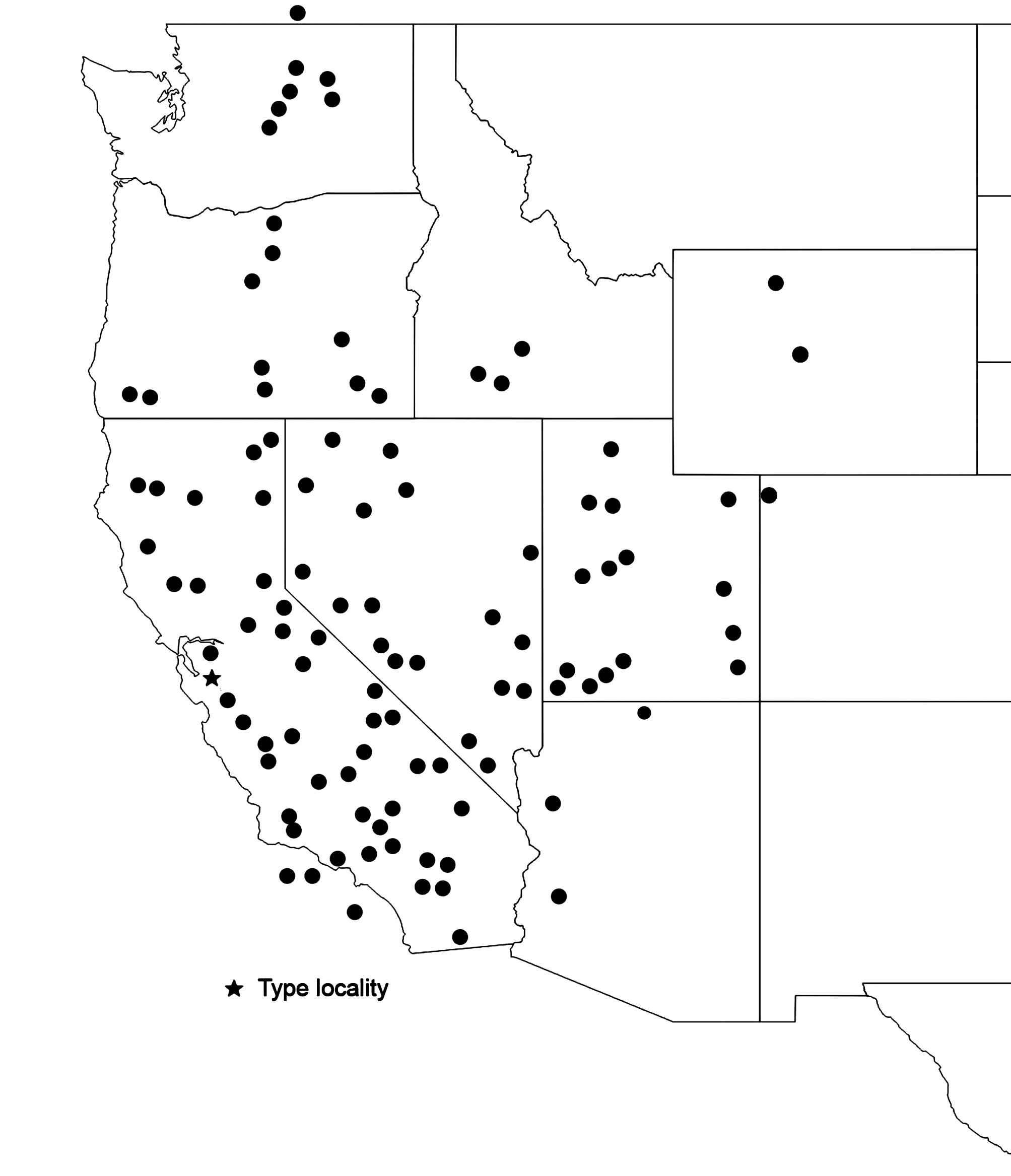
Geographic range. Fig. 242 View FIGURE 242 . Also into northern Baja California, Mexico. Only known populations east of the Continental Divide are those in Wyoming.
Habitat. Tolerant of widely varying ecological conditions from elevations between - 57m (Furnace Creek, Death Valley National Monument, CA S83-60) to over 2200m ( Inyo Co., Westgard Pass, S 98-98 & S16-17) up to around 2500m at Whitney Portal campgrounds (S78-119), but almost always associated with rocks. Occasionally in cracks of buildings (Halloran Springs Microwave, S91-69) or debris piles in dry river bed bottoms (Jacalitos Canyon, S01- 100). Rarely climbs> 1-2m in vegetation, but one male singing from palm tree 10m above ground at Furnace Creek (S83-60). Does climb within rocks along cliff faces (e.g. Long Canyon, Burr Trail, Boulder Co., Utah; Checkerboard Mesa, Zion National Park, Kane Co., Utah); also in rocks supporting railroad tracks in Mojave, CA (S83-117).
Life cycle and seasonal occurrence. No egg diapause: UT, Box Elder Co. (S87-50); CA, Halloran Springs Microwave (S91-69); Reno, NV (S02-63, S03-99); British Columbia (S04-62); NV, Current Summit (S09-140); UT, Dugway Proving Grounds (S13-79); UT, Millard Co., Fillmore (S17-7). Probably one generation/year in Southern and Central California as adults present in May but almost none heard singing by August, which is when a sec- ond generation, if present, would be maturing. On the other hand, there appears to be 2 generations/year in Reno, Washoe Co., NV. In early May, 2004 (S04-31), singing males were heard throughout town. We collected 9♂ 1♀ and 1 last instar ♀ that soon molted to adult. On 23-viii-2002 (S02-63) we collected 7♂ 2♀ along with 2 mid-late instars, but singing males were geographically restricted. Eggs from those 2 adult females had no diapause. On 31- viii-2003 (S03-99) we collected 6♂ 2♀ and 3 mid-late nymphs. Eggs from those females also had no diapause. One collected female nymph was a last instar 3-xi-2003 and an adult 1-v-2004 (in a laboratory minimally heated during the winter). Further work over several years with more sampling, and variable rainfall, is needed to interpret this pattern.
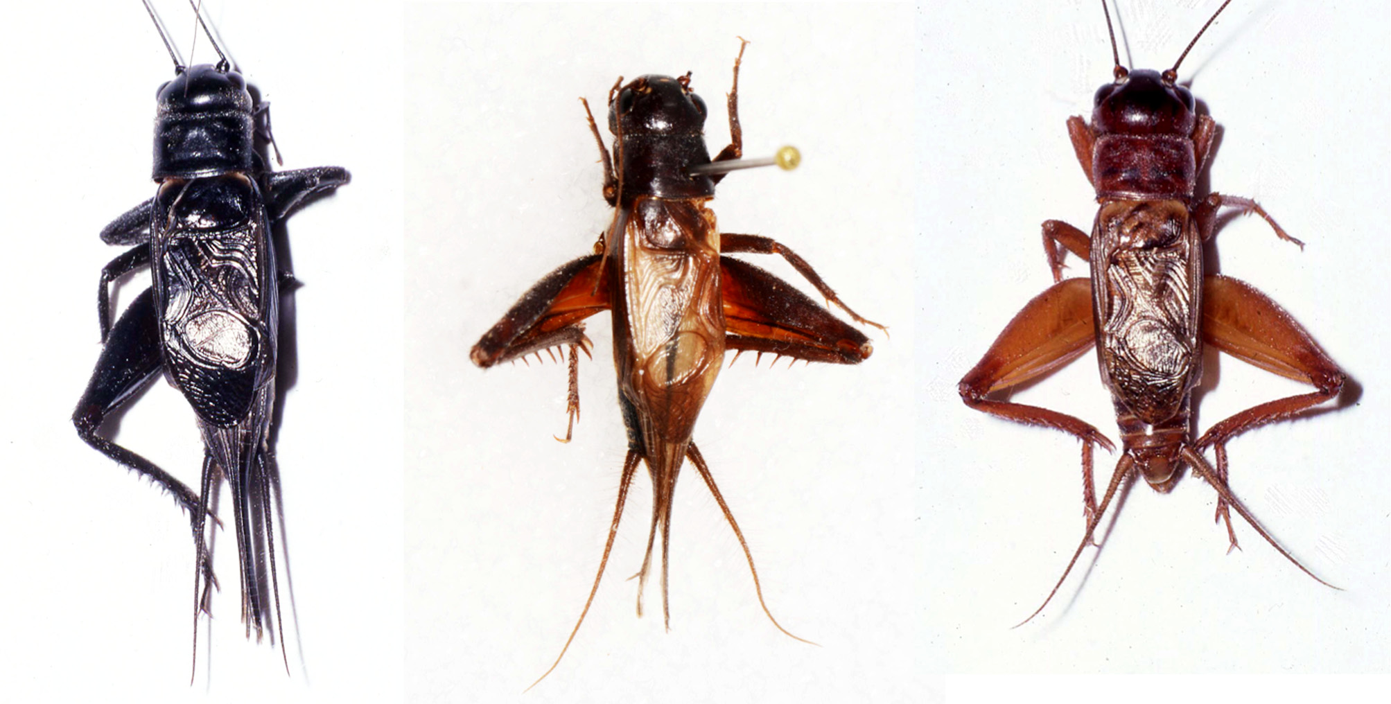
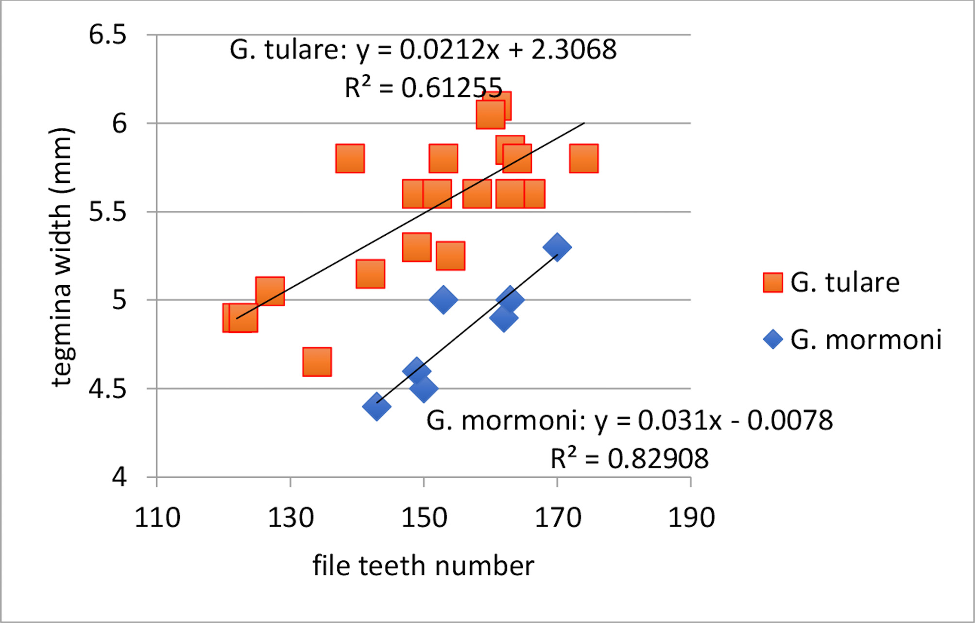
Variation. Body color: Generally dark ( Fig. 243 View FIGURE 243 ) but reddish individuals known ( Fig. 243 View FIGURE 243 , CA, Jacalitos Canyon, S01-97). Hind wing length: see “Discussion” below. Number file teeth: Varies from 122-190 ( Fig. 244 View FIGURE 244 ), a greater range than typically seen in a Gryllus species with a more limited distribution. Tegminal bars present in certain populations: 2 of 7 field collected adult females from UT, Millard Co., Fillmore (S17-7); in both sexes from CA, Kern Co., Tehachapi (S09-29).
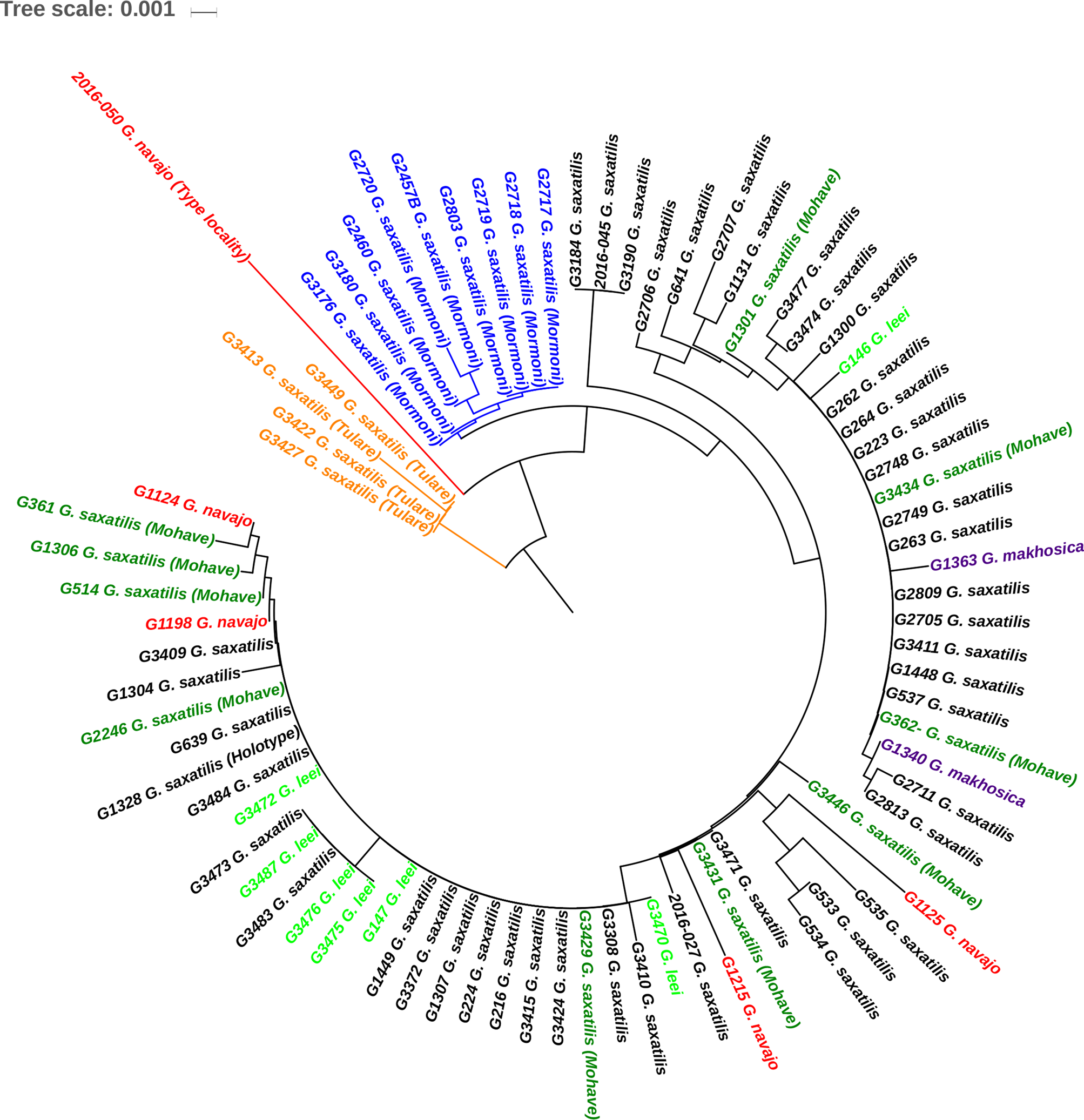
, - DNA. G. saxatilis falls within a clade of closely related western chirping species that we recognize here as G. saxatilis , G. leei , G. makhosica , and G. navajo . Multilocus G3310 Mt. Hamilton, CA (S15-114— type locality for G. saxatilis ); G3484 Fillmore, UT (S17-7—locality of G. saxatilis nearest [14 km east] to type locality of G. leei ); G3431 Big Pine, CA (S16-18—‘G. mojave’, where all 12 collected individuals had long hind wings); and G1131 Kingman, AZ (S07-64— ‘ G. mojave’) all map (Gray et al. 2019) in a group of rock chirpers along with Utah G. leei , South Dakota G. makhosica , Arizona and Utah G. navajo , and California ‘ G. tulare’ and ‘G. mormoni’. Individuals of G. saxatilis from Mt. Pass, CA, (S16-23), near Goffs, CA (S16-32), and Searchlight, NV (S16-33) all have the same 16S sequence that we found in ‘ G. tulare’. ITS2 ( Fig. 238 View FIGURE 238 , p. 236 View FIGURE 236 ) does a poor job resolving within the S axatilis Group, specifically G. makhosica , G. leei , and G. navajo ITS2 sequences are intermingled with G. saxatilis . Ironically, the ‘tulare’ and ‘mormoni’ forms, which we do not recognize here as distinct species, are better resolved by ITS2 than the taxa we do recognize. Further work is clearly warranted; analysis of SNP data from rad-seq on a large series of G. saxatilis and G. navajo is already underway (Collosi et al., in prep.), see discussion under G. navajo , p. 258.
Discussion. This species was initially split into several groups, mostly for convenience, based on geography and some physical differences. All populations in California, Oregon, and Washington west of the Sierras and Cascades were called ‘G. #2’. Those populations in California, Oregon, and Washington east of the Sierras and Cascades, and those collected in southern Idaho and Nevada were designated ‘G. #11’. Populations from Utah, northern Arizona, and Wyoming were labeled ‘G. #22’. And lastly, those individuals not always associated with rocky habitats but with human habitation, and with long hind wings and small heads, from the Great Basin and Mojave Desert areas of California, southern Nevada and adjacent Arizona, were called ‘G. #38’ or ‘G. mojave’. While we suspect that cryptic species may exist within this geographically diverse assemblage, we are not able to separate them either morphologically or with DNA profiles. All have similar songs and have been included as paratypes under G. saxatilis .
) Still, the most likely cryptic taxon are those individuals considered to be ‘ G. mojave’ based on the common, but not universal, reduced head width and almost universal presence ( Fig. 243 View FIGURE 243 ) of long hind wings (e.g. all 9 males and 25 females from Kingman, AZ (S92-113); all 11 males and 10 females from Halloran Springs (S91-69) and, in total, 97 of 120 males [81%] and 84 of 85 females [99%] from the Great Basin and Mojave Desert, where we considered all collected G. saxatilis to be ‘ G. mojave’. Most of these just discussed, long hind-winged individuals were from areas of human influence, either adjacent to or within town boundaries or outside towns but associated with human structures. In contrast, a nice series of 14 individuals of G. saxatilis , collected by A. Abela in undisturbed Great Basin Desert habitat, Churchill Co., NV (S18-32, 33, 36), all had short hind wings. Also, only one of 8 males and the only female from another undisturbed, (high elevation— 2216m) locality, Westgard Pass, CA, on the western edge of the Great Basin, had long hind wings. And away from the Great Basin and Mohave Deserts, only 6 of 530 adults (~1%) had long hind wings. It thus appears that a combination of living with human influence within and near the Great Basin and Mojave Deserts, favors adults with long hind wings.
On the 21-km-long road between Hualapai Mt. Rec. Area and Kingman, Arizona, going from 2042m to 1128m, there are 4 species of medium sized, medium-long length cerci, slow chirping Gryllus species. G. montis is highest in the pine-oak forest, but extends into the higher elevation interior chaparral as low as 1585m. Once out of the forest driving almost due west through interior chaparral, faster chirping G. lightfooti is heard starting at 1738m and heard into Kingman. G. longicercus starts at 1646m, drops out at 1433m, and is then heard again in Kingman. G. saxatilis was first heard in 1992 (S92-113), on the outskirts of Kingman, at 1128m, in large numbers (9 males and 25 females, all with long hind wings. In 2007 (S07-64), only one male G. saxatilis , with long hind wings, heard and collected at 1783m. Three species ( G. montis , G. longicercus , and G. saxatilis ) heard microsympatric, in both 1990 (S90-56) and 1991 (S91-65), at 14 km SE Kingman at 1646m.
Five tachinid Ormia ochracea emerged from 1 male near Palm Desert, CA (S09-20); one O. ochracea emerged from a male from Corn Springs, Riverside Co., CA (33.625, -115.333) collected 10-iv-2015 —seasonally among the earliest O. ochracea we have encountered. One, two, and three tachinid Exoristoides johnsoni emerged from three males from Fallon, NV (S98-95). One tachinid E. johnsoni emerged from each male, both collected as nymphs, from 6.4 km N Winnemucca, NV (S98-22). For such a widespread species, this is a surprisingly low parasitism rate. Perhaps this rate is reduced by having only 1 early-season generation/year, before the tachinid fly numbers become significant.
One female G. saxatilis , Oregon, Josephine Co., 13 km W Selma (S92-79) with horsehair worm. One male, California, Tulare Co. (S03-27) with mermithid worms (see Poinar & Weissman 2004).
Occasional males continue to sing while turning over rocks attempting a capture—a behavior also seen in G. longicercus .
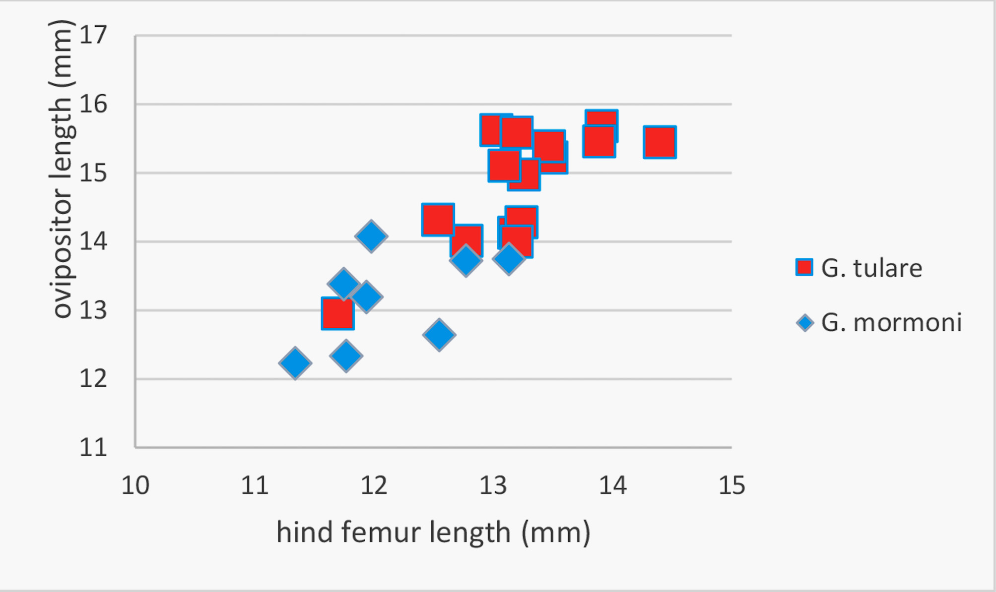
Two geographically restricted areas of G. saxatilis give us pause, based primarily upon DNA results. We gave individuals from these two areas tentative names, and we now discuss them: ‘G. mormoni’ is from the area around Folsom Lake, CA, and ‘G. tulare ’ is from Tulare Co., CA. They both have 16S, ITS2, and multilocus DNA sequences distinctive from other G. saxatilis and from each other. Since neither can be morphologically or ecologically separated from typical G. saxatilis , and in the absence of any vicariant physical barrier, we tentatively place them together with the nominate species and discuss them below, but do not consider them paratypes. Comparing ‘G. mormoni’ vs. ‘G. tulare’, they can be separated by DNA ( Fig. 238 View FIGURE 238 ), almost non-overlapping teeth/mm ( Table 1 View TABLE 1 , p. 18), non-overlapping file teeth vs. tegmina width ( Fig. 245 View FIGURE 245 ), and little overlap between hind femur length vs. ovipositor length ( Fig. 246 View FIGURE 246 ), although the latter could be the simple result of larger body size in ‘G. tulare’.
‘G. mormoni’ Known only from around Folsom and Placerville, in California’s Sacramento Valley, that portion of the California Central Valley that lies to the north of the Sacramento-San Joaquin River Delta. Medium sized, generally black, narrow pronotum, medium length cerci and always short hind wings. Song a slow chirp (1.5-2.5 C/S), 4-5 P/C, PR 17-21 at 25°C. Separated from nominate G. saxatilis by DNA ( Fig. 238 View FIGURE 238 ) and the narrower tegmina in ‘G. mormoni’ ( Table 1 View TABLE 1 , p. 18). Additionally, paratype G. saxatilis not known from the Central Valley floor proper but only in foothills of adjacent mountain ranges to the west (e.g. Jacalitos Canyon near Coalinga, Fresno Co.; Tar Canyon near Kettleman City, King Co.); to the north (e.g. Lake Shasta, Shasta Co.); and east (West Point, Calaveras Co.).
Specimens studied. (23♂ 18♀). California. El Dorado Co., 4.7 air miles NE Placerville, Mosquito Rd near mile post 5.64, 8-viii- 2014, 519m, 38° 46’ 34.76” -120° 45’ 08.57’ (S14-77) 4♂ 1♀ . Sacramento Co., Folsom, intersection of Folsom Blvd. and Hwy 50, 174’, 19-vii-2015 (S15-87) 6♂ 2♀ ; Folsom, intersection of Folsom Blvd. and Blue Ravine Rd. , 19-vii-2015 (S15-88) 5♂ 7♀ . Folsom Lake SRA, Beal’s Point area near Folsom Dam, 463’, 6-v-2013, 38° 43’ 06.61” -121° 10’ 10.18”, 29-iii-2005 (S05-38) 2♂ , collected as mid instars; 6-v-2013 (S13-10A) 6♂ 8♀.
Derivation of name. Named for Mormon Island, a California mining community that developed, starting in 1848, after gold was discovered on the south fork of the American River. The community was subsequently razed and covered with water from Folsom Lake, which formed in 1955, after the construction of Folsom Dam. Due to California’s record drought from 2012-2017, parts of Folsom Lake were exposed, where we collected a nice series in 2015. Mormon Island is designated as California Historical Landmark #569.
Habitat. The Folsom Lake locality is open, short grassland, with rocks, lying in the completely dry, exposed part of “Folsom Lake”, which may have been submerged in 2019 after an above-average rainfall year. A few males also singing from under adjacent rocks at the base of Folsom Dam. Similar sounding males also singing within oak-woodland of Folsom Lake SRA but none collected and species identity not confirmed as similar sounding G. veletisoides also occurs in the area. The two localities within Folsom city limits (S15-87, S15-88) were open areas with dirt and few rocks, the latter adjacent to the railroad tracks. Mosquito Road is 37 air km from the first locality and more typical habitat of G. saxatilis comprised of oak woodland with dirt road banks but few rocks. Crickets were heard for some 3 km along Mosquito Rd. between 511m and 684m elevation.
Life cycle and seasonal occurrence. No egg diapause (S14-77). One generation/year with nymphs overwintering as mid-late instars since late-instars present in late March and adults present and singing in early May. F 1 nymphs, from laboratory laid eggs, started molting to adults, in May, one year after they were laid.
‘ G. tulare’ Only known from Tulare Co., California, always with short hind wings. Song a slow chirp (3) 4 (5) p/c, 90-225c/m, PR 15.2-23.8 at 25°C. Separated from nominate G. saxatilis by DNA ( Fig. 238 View FIGURE 238 ).
Specimens studied. (31♂ 17♀). California. Tulare Co., Hwy 190 3.2 m E Springville , 1620’, 20-viii-2006 (S06-81) 1♂ . Hwy 190 6.5-10 m E Springville , 2320-3460’, 29-v-2009 (S09-34, 35) 17♂ 13♀ . Hwy 190 0.5 m W Pierpoint Springs , 4700’, 4-v-2003 (S03-27) 2♂ 2♀ . Hwy 190 5.4 m W Pierpoint Springs , 3700’, 4-v-2003 S03-28) 5♂ . Hwy 198 4.4 m E Lemon Cove , 725’, 28-vi-2016 (S16-21) 6♂ 2♀ .
Habitat. From 221-1433m elevation. Habitat typical for G. saxatilis : oak-woodland borders, chaparral, road cuts always associated with rocks.
Life cycle and seasonal occurrence. One generation/year, egg diapause not checked but undoubtedly absent as adults present in late spring. Mid-late instars seen early May (S03-27 & 28) and a last instar female seen late May (S09-35) when most of population adult.
Variation. Cerci length: Longer than ovipositor in situ in only one female (S09-34). Color: Hind femur normally varies from small reddish area medially where attaches to body to entire femur reddish with rest of hind leg black. Two males (S03-27 and S06-81) with entire hind legs reddish. File teeth: Vary from 122–174. All of these males have medium length cerci and DNA consistent with ‘G. tulare.’ The three G. saxatilis males with the fewest teeth (122–149, see Fig. 244 View FIGURE 244 , p. __) are in this ‘G. tulare’ group (S03-28, W Pierpoint Springs), collected on 4-v- 2003, and raised through the last few instars in the laboratory.


| MK |
National Museum of Kenya |
| CAS |
California Academy of Sciences |
No known copyright restrictions apply. See Agosti, D., Egloff, W., 2009. Taxonomic information exchange and copyright: the Plazi approach. BMC Research Notes 2009, 2:53 for further explanation.