
Amalda fuscolingua Kilburn & Bouchet, 1988
|
publication ID |
https://doi.org/10.5852/ejt.2020.706 |
|
publication LSID |
lsid:zoobank.org:pub:C4C4D130-1EA7-48AA-A664-391DBC59C484 |
|
DOI |
https://doi.org/10.5281/zenodo.4333192 |
|
persistent identifier |
https://treatment.plazi.org/id/03A7D504-FFD0-FFE6-647F-FECCA6E5F9F0 |
|
treatment provided by |
Valdenar (2020-09-01 17:39:56, last updated 2024-12-06 19:50:54) |
|
scientific name |
Amalda fuscolingua Kilburn & Bouchet, 1988 |
| status |
|
Amalda fuscolingua Kilburn & Bouchet, 1988
Fig. 9B View Fig , 18 View Fig A–E
Amalda fuscolingua Kilburn & Bouchet, 1988: 288–289 , figs 25–28, 40–41, 54.
Amalda fuscolingua – Gratecap 2014: 14, 18, figs 11–13.
Type material
Holotype
SOUTHERN NEW CALEDONIA • S of Île des Pins ; 22°54′ S, 167°14′ E; 412–428 m deep; SMIB 2; stn DW03; MNHN IM-2000-1439. GoogleMaps
Material examined
Sequenced material
8 sequenced specimens ( Table 1).
Not sequenced material
SOUTHERN NEW CALEDONIA • material listed by Kilburn & Bouchet (1988) • 1 dd; SW of Île des Pins ; 22°56′ S, 167°15′ E; 437 m deep; SMIB 3; stn DW25 GoogleMaps • 1 dd; SW of Île des Pins ; 22°46′ S, 167°11′ E; 394 m deep; SMIB 3; stn DW28 GoogleMaps • 4 dd; SW of Île des Pins ; 22°47′ S, 167°12′ E; 405 m deep; SMIB 3; stn DW29 GoogleMaps • 1 lv; 3 dd; between Île des Pins and Grand Récif Sud; 22°56′ S, 167°14′ E; 400– 420 m deep; SMIB 4; stn DW65 GoogleMaps • 1 dd; between Île des Pins and Grand Récif Sud; 22°56′ S, 167°15′ E; 400–430 m deep; SMIB 4; stn DW66 GoogleMaps • 1 dd; between Île des Pins and Grand Récif Sud; 22°55′ S, 167°15′ E; 395–405 m deep; SMIB 4; stn DW69 GoogleMaps • 15 lv, dd; E of Île des Pins ; 22°51′ S– 22°52′ S, 168°12’ E– 168°13′ E; 408–436 m deep; SMIB 8; stn DW197-199 GoogleMaps • 15 lv, dd; SE slope of Passe de Dumbéa ; 22°52′ S, 167°12′ E; 400 m deep; BATHUS 2; stn DW729 GoogleMaps • 15 dd; S of Île des Pins ; 22°44′ S, 167°17′ E; 350–393 m deep; BATHUS 2; stn DW717 GoogleMaps • 3 dd; S of Île des Pins ; 22°50′ S, 167°27′ E; 430–433 m deep; BATHUS 2; stn DW723 GoogleMaps • 10 dd; S of Île des Pins ; 22°48′ S, 167°26′ E; 344–358 m deep; BATHUS 2; stn DW724 GoogleMaps • 6 dd; Canal de la Havannah ; 22°13′ S, 167°09′ E; 353–365 m deep; EXBODI; stn DW3784 GoogleMaps • 1 dd; Canal de la Havannah ; 22°15′ S, 167°10′ E; 386–387 m deep; EXBODI; stn DW3785 GoogleMaps • 7 dd; SW of Île des Pins ; 22°57′ S, 167°16′ E; 427–433 m deep; NORFOLK 1; DW1733 GoogleMaps • 15 lv, dd; SW of Île des Pins ; 22°52′ S, 167°12′ E; 383–407 m deep; NORFOLK 1; stn DW1736 GoogleMaps • ca 30 lv, dd; SW of Île des Pins ; 22°51′ S, 167°10′ E; 400 m deep; NORFOLK 1; stn DW1737 GoogleMaps ; • 15 dd; SW of Île des Pins; 22°51′ S, 167°12′ E; 340–381 m deep; NORFOLK 1; stn DW1738. GoogleMaps – Off Île des Pins • 10 dd; 22°44′ S, 167°16′ E; 386–391 m deep; NORFOLK 2; stn DW2148 GoogleMaps • 12 dd; 22°43′ S, 167°14′ E; 353–368 m deep; NORFOLK 2; stn DW2151 GoogleMaps • 4 dd; 22°47′ S, 167°12′ E; 395–400 m deep; NORFOLK 2; stn CP2153 GoogleMaps • 25 dd; 22°54′ S, 167°15′ E; 468–500 m deep; NORFOLK 2; stn DW2156 GoogleMaps • 1 lv; 22°45′ S, 167°13′ E; 400–405 m deep; KANACONO; stn DW4660; MNHN IM-2013-68426 GoogleMaps • 2 lv; 22°57′ S, 167°39′ E; 310–403 m deep; KANACONO; stn DW4745; MNHN IM-2013-63419 ; MNHN IM-2013-63425 GoogleMaps .
Description
MEASUREMENTS. Shell large (SL up to 57 mm).
SHELL. Ovate-fusiform, with blunt orthoconoid spire. Primary spire callus thick, microshagreened, covering all whorls, except 1–1.5 protoconch whorls. First protoconch whorl diameter 0.92–1.06 mm (mean 0.98, n=5). Secondary callus thick, fusing without visible border with parietal callus, with distinct anterior border, reaching suture of antepenultimate whorl. Plication plate with 3–6 ridges, all weak except outer 2, columella smooth. Olivoid groove very shallow to obsolete, labral denticle very small, obtuse to absent. Upper anterior band nearly flat except weak submedian low ridge. Lower anterior band nearly flat, microshagreened. Primary callus orange-brown in lower part, brown on spire with distinct, strongly prosocline, lighter axial lines. Secondary callus orange-brown. Body whorl cloak light yellowish-brown, olivoid band usually slightly lighter, anterior band orange brown with upper anterior band slightly darker, of the same colour as cloak, plication plate white.
Remarks
This distinct species poses no taxonomic problems due to its very characteristic colour pattern of primary spire callus with strongly prosocline lighter axial lines and brightly coloured thick orangebrown secondary callus. There is no species in New Caledonia resembling A. fuscolingua .
The radula, examined by Kilburn & Bouchet (1988: fig. 54), is similar to that of A. montrouzieri with central tooth with less serrated cusps.
Distribution The species is confined to a narrow perimeter around Île des Pins ( Fig. 9B View Fig ), with a maximal extension
of 150× 60 km and a depth range of 300– 500 m.
Bozzetti L. 2007. Due nuove Amalda (Gastropoda: Hypsogastropoda: Olividae) dalla Nuova Caledonia. Malacologia Mostra Mondiale 56: 14 - 16.
Gratecap D. 2014. Le genre Amalda en Nouvelle-Caledonie. Xenophora 146: 13 - 20.
Kilburn R. N. & Bouchet P. 1988. The genus Amalda in New Caledonia (Mollusca, Gastropoda, Olividae, Ancillinae). Bulletin du Museum national d'histoire naturelle, ser. 4, 10, section A 2: 277 - 300.
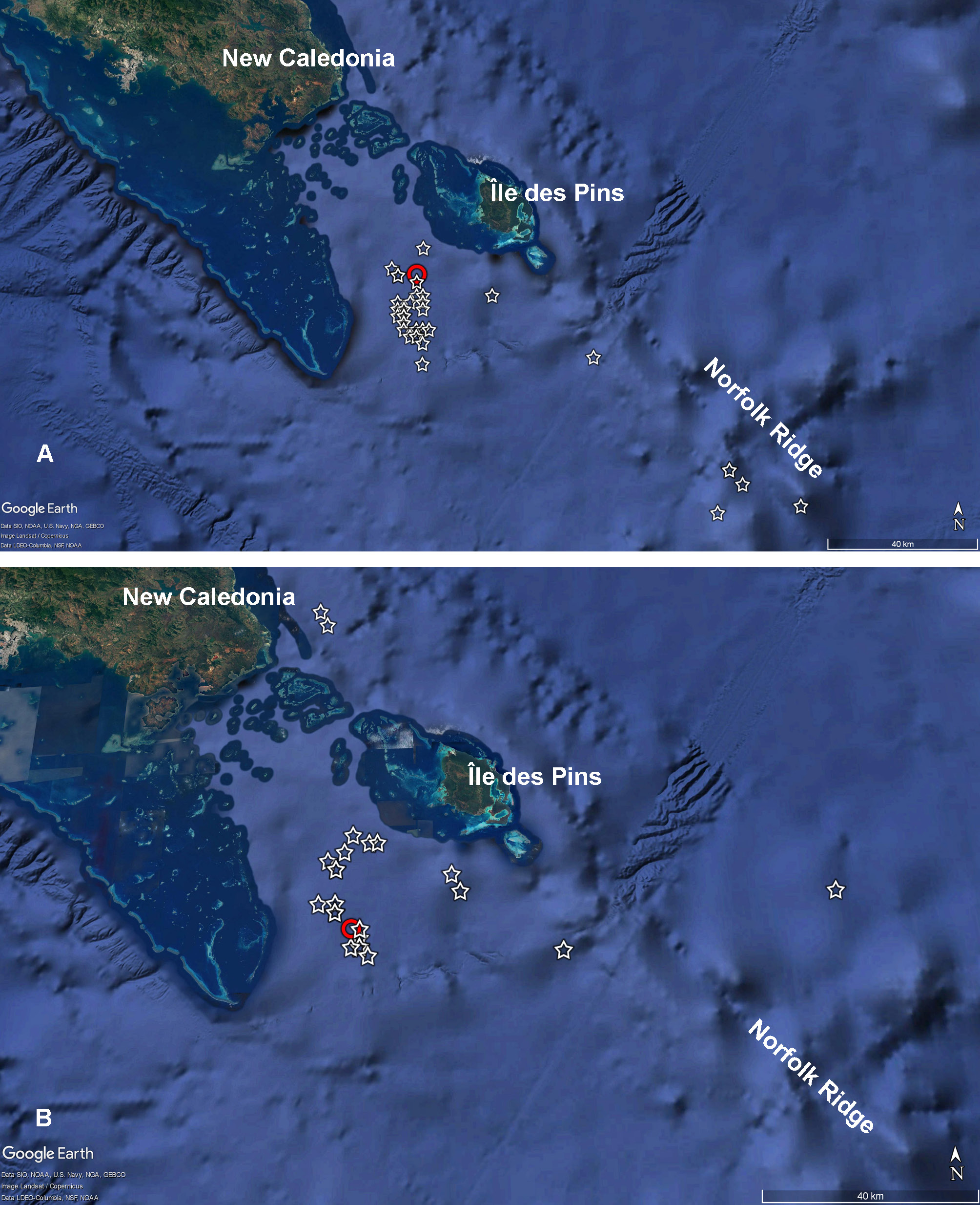
Fig. 9. Distribution map of Amalda aureomarginata Kilburn & Bouchet, 1988 (A) and A. fuscolingua Kilburn & Bouchet, 1988 (B) off southern New Caledonia. Red circles=the typelocalities; stars= indicate stations where the species were recovered.
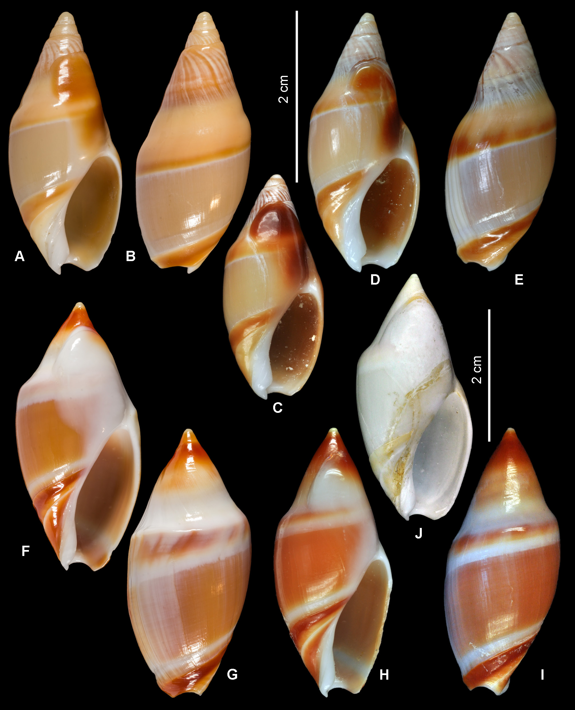
Fig. 18. A–E. A. fuscolingua Kilburn & Bouchet, 1988. A–B. Holotype, MNHN IM-2000-1439, SL 30.6 mm. C. MNHN IM-2007-43643, SL 26.6 mm (sequenced specimen). D–E. MNHN IM-2007- 43649, SL 30.2 mm (sequenced specimen). F–J. A. coriolis Kilburn & Bouchet, 1988. F–G. Holotype, MNHN IM-2000-1393, SL 40.1 mm. H–I. MNHN IM-2013-63899, SL 40.4 mm (sequenced specimen). J. Coral Sea, Capel Bank, KANADEEP, stn DW4944, 25°21′ S, 159°45′ E, 235–242 m, SL 37.3 mm. A–E= at the same scale; F–J =at the same scale.
No known copyright restrictions apply. See Agosti, D., Egloff, W., 2009. Taxonomic information exchange and copyright: the Plazi approach. BMC Research Notes 2009, 2:53 for further explanation.
|
Kingdom |
|
|
Phylum |
|
|
Class |
|
|
SubClass |
Caenogastropoda |
|
Order |
|
|
Family |
|
|
Genus |
Amalda fuscolingua Kilburn & Bouchet, 1988
| Kantor, Yuri I., Castelin, Magalie, Fedosov, Alexander & Bouchet, Philippe 2020 |
Amalda fuscolingua
| Gratecap D. 2014: 14 |
Amalda fuscolingua
| Kilburn R. N. & Bouchet P. 1988: 289 |
1 (by valdenar, 2020-09-01 17:39:56)
2 (by ExternalLinkService, 2020-09-01 17:46:38)
3 (by valdenar, 2020-09-01 20:35:40)
4 (by ExternalLinkService, 2020-09-01 20:59:15)
5 (by ExternalLinkService, 2020-12-17 09:55:18)
6 (by ExternalLinkService, 2021-09-19 03:30:16)
7 (by plazi, 2023-10-31 22:29:06)
8 (by ExternalLinkService, 2023-11-01 13:36:22)
9 (by valdenar, 2023-11-22 11:37:36)
10 (by ExternalLinkService, 2024-11-29 15:40:55)