
Zagrammosoma buselus (Walker)
|
publication ID |
https://doi.org/ 10.11646/zootaxa.4916.1.1 |
|
publication LSID |
lsid:zoobank.org:pub:803ED7FD-4A09-44F4-AAE2-6F70A0509E86 |
|
DOI |
https://doi.org/10.5281/zenodo.4474156 |
|
persistent identifier |
https://treatment.plazi.org/id/BC53327A-FF9A-6C15-25CF-FBC9D38CC275 |
|
treatment provided by |
Plazi |
|
scientific name |
Zagrammosoma buselus (Walker) |
| status |
|
Zagrammosoma buselus (Walker) View in CoL
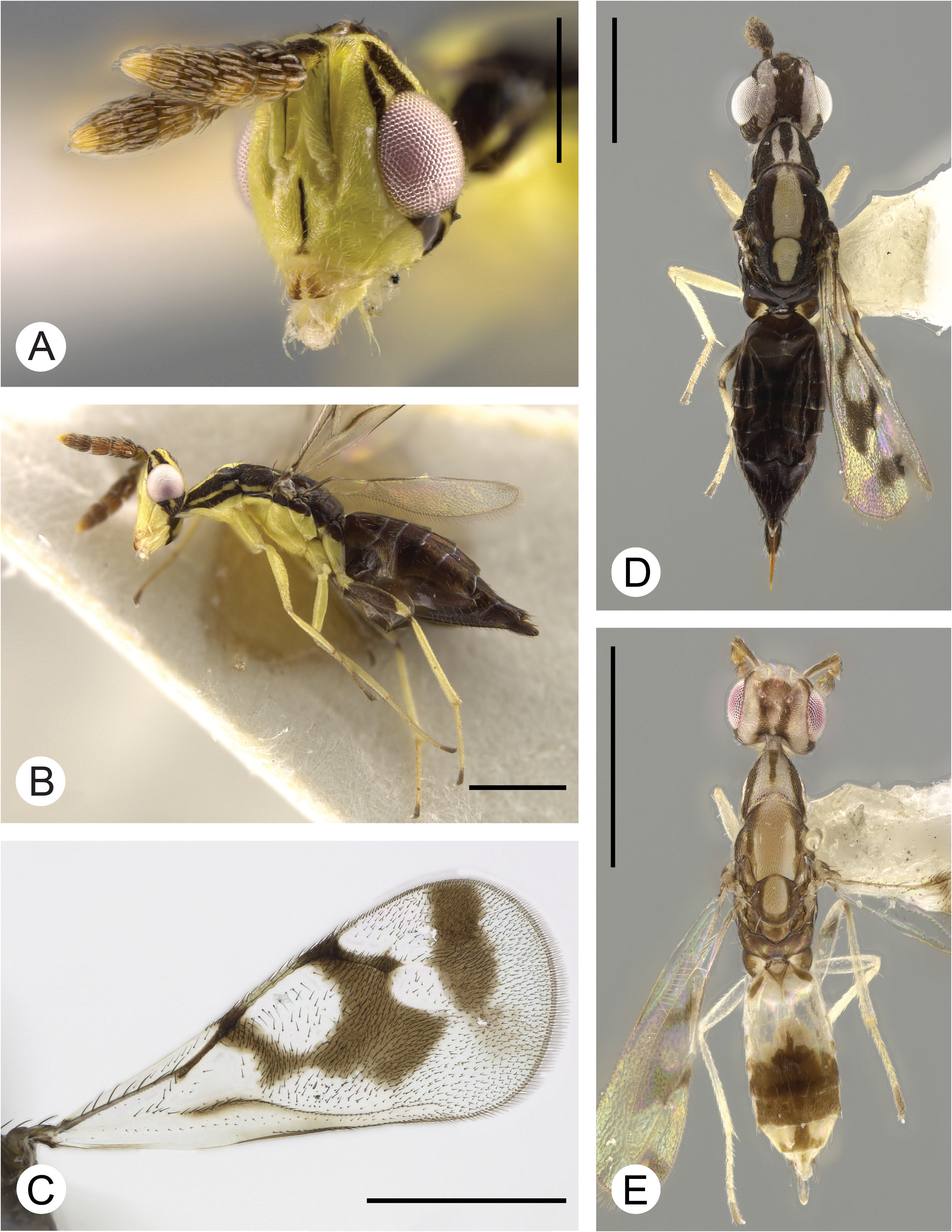
( Fig. 6 View FIGURE 6 )
Cirrospilus buselus Walker, 1839: 96 View in CoL . Lectotype ♀ designated by LaSalle & Schauff 1992: 23. Type locality: Ecuador, Galapagos Islands, coll. C. Darwin, 1835. Type depository: BMNH: NHMUK010370942.
Zagrammosoma buselus View in CoL ; combination by LaSalle & Schauff 1992: 23.
Diagnosis. Zagrammoma buselus is characterized by a completely dark gaster, yellow mesoscutellum, and a medial, dark band on the mesoscutum that tapers to a point before reaching the mesoscutellum ( Fig. 6D, E View FIGURE 6 ). This species is most similar to Z. flavolineatum but can be differentiated by the yellow mesoscutellum, whereas Z. flavolineatum has the mesoscutellum black laterally, with a yellow band in the center ( Fig. 16D, E View FIGURE 16 ). Male Z. buselus have a dark gaster, whereas male Z. flavolineatum have posteriorly a dark medial patch on Gt 3 – Gt 6 ( Fig. 16E View FIGURE 16 ). The wing patterns of each species are distinctive ( Fig. 6C View FIGURE 6 versus 16C).
Description. Female - body length 0.97–1.86 mm. Metallic luster on body absent. Scape yellow with black stripe dorsally. Lower face with median stripe. Vertex with 2 stripes above compound eye. Gena posteriorly with broad dark band below compound eye, sometimes with central yellow spot. Occiput yellow with dark median band, sometimes band is bisected by a faint yellow stripe. Pronotum dorsally with broad median stripe, either interrupted or complete; laterally with 2 black stripes. Prepectus yellow with dorsal margin dark. Mesoscutellum yellow with broad median stripe tapering posteriorly. Propodeum all dark. Procoxa and mesocoxa yellow. Metacoxa mostly yellow, basally dark. Profemur and mesofemur yellow. Metafemur dark except at tips. Fore wing: basal band absent; cubital band present; parastigmal, stigmal, and postmarginal bands present, with perpendicular extension greater than length of stigmal vein; apical band absent; connection from parastigmal band to stigmal band present; connection from stigmal band to postmarginal band absent. Hind wing hyaline. Gaster dark.
Upper ocular sulcus present. Pedicel longer than wide. Funiculars symmetrical: first longer than wide (w:l = 0.67–0.77); second subequal or wider than long (w:l = 1.0–1.11).
Pronotum, in dorsal view, bell-shaped, wider than long (w:l = 1.46–1.52); 3–4 pairs of setae along posterior margin. Mesoscutum reticulate; without scattered setae; intermediate setae present. Mesoscutellum wider than long (w:l = 1.08–1.24); submedian grooves absent. Hind tibial spur distinctly shorter than basitarsus. Hind basitarsus longer than second tarsomere (bst:2 nd = 1.11–1.2).
Fore wing l:w = 2.12–2.58. Submarginal vein with 5–6 setae dorsally. Basal fold setose. Cubital fold setose. Admarginal setae present. Uncus originating on stigma by its own length or less from stigmal apex, or by more than length of uncus.
Male - as female, except: body length 0.8–0.97 mm.
Remarks. This endemic species is the most abundant of the three species of Zagrammosoma recovered in the Galapagos archipelago, with 236 specimen records compared to 22 of Z. multilineatum , and 9 of the other endemic species, Z. galapagoense . The body and wing patterns of Z. buselus make this one of the most distinctive species of Zagrammosoma .
Hosts. unknown.
Distribution. Neotropical: Ecuador: Galapagos Islands ( Fig. 7 View FIGURE 7 ).
Etymology. Unknown, however, Walker (1839) named species in his monograph after ancient Greek, Roman, and Macedonian figures, some real, some mythological. The name Buselus is found in the “Orations of Demosthenes, against Macartus” (Demosthenes 43).
Type material examined. Lectotype: ECUADOR: Galapagos: Santiago Island , 405m, 0°14’26”S, 90°42’54”W, 8–17.x.1835, C. Darwin [1♀, BMNH: NHMUK010370942 ]. GoogleMaps
Additional material examined. ECUADOR: Galapagos: Fernandina Island, 10 km NE Cabo Hammond , 400m, 0°25’9”S, 91°34’52”W, 9.v.1991, J. Heraty, transition, H91-027 [1♀, UCRC: UCRCENT485706 View Materials ] GoogleMaps . Isabela Island, Alcedo , 14km S. NE Playa, 1100m, 0°36’39”S, 90°40’2”W, 23.vi.1991, J. Heraty, scrub/pampa, H91-109 [2♁ 9♀, UCRC: UCRCENT447809–447819 View Materials ]. GoogleMaps Cerro Azul, 3km E. Caleta Iguana, 200m, 0°59’56”S, 91°24’48”W, 25.v.1991, J. Heraty, decid. forest, H91-061 [1♀, UCRC: UCRCENT447807 View Materials ]. GoogleMaps Cerro Azul, 3km E. Caleta Iguana, 300m, 0°57’40”S, 91°26’23”W, 20.v.1991, J. Heraty, pampa, H91-045 [3♁ 7♀, BMNH: NHMUK10370148 , 10370151 , UCRC: UCRCENT444411–444416, 498885, 498887]. GoogleMaps Cerro Azul, 4 km E. Caleta Iguana, 300mm, 0°56’7”S, 91°27’30”W, 24.v.1991, J. Heraty, pampa transition, H91-060 [2♁ 3♀, UCRC: UCRCENT414295 View Materials , 447764–447767 View Materials ]. GoogleMaps Cerro Azul, 5km E. Caleta Iguana, 400m, 0°59’15”S, 91°24’25”W, 24.v.1991, J. Heraty, pampa/ grass, H91-059 [4♁ 11♀, UCRC: UCRCENT337750 View Materials , 447750 View Materials , 447792–447800 View Materials , 447803–447806 View Materials ]. GoogleMaps Cerro Azul, 7km E. Caleta Iguana, 600–700m, 0°58’10”S, 91°25’6”W, 23–24.v.1991, J. Heraty, pampa, H91-053 [4♁ 12♀, UCRC: UCRCENT447768–447782 View Materials , USNM: UCRCENT471434 View Materials ]. GoogleMaps Cerro Azul, 7km E. Caleta Iguana, 600m, 0°58’15”S, 91°25’12”W, 20–25.v.1991, J. Heraty, pampa, Pan Trap, H91-055 [1♀, UCRC: UCRCENT447808 View Materials ]. GoogleMaps Cerro Azul, 7km E Caleta Iguana, 600m, 0°58’15”S, 91°25’12”W, J. Heraty, grass pampa [2♁ 3♀, ANIC: UCRCENT238225 View Materials , CNC: CNC508704, UCRC: UCRCENT414294, 447801, 447802]. GoogleMaps Cerro Azul, 7km E. Caleta Iguana , 700m, 0°58’10”S, 91°24’55”W, 20.v.1991, J. Heraty, pampa, H91-046 [10♁ 3♀, UCRC: UCRCENT444417–444427 View Materials , USNM: UCRCENT471433 View Materials , 471435 View Materials ]. GoogleMaps Cerro Azul, 8km E. Caleta Iguana , 850m, 0°57’13”S, 91°25’28”W, 24.v.1991, J. Heraty, crater/grass, H91-054 [1♁ 9♀, ANIC: UCRCENT238222 View Materials , BMNH: NHMUK10370146 , CNC: CNC508705, 508706, UCRC: UCRCENT447783–447788 View Materials ]. GoogleMaps Cerro Azul, 8km E. Caleta Iguana , 850m, 0°57’40”S, 91°24’59”W, 22.v.1991, J. Heraty, Crater/grass, H91-051 [1♁ 12♀, UCRC: UCRCENT447751–447763 View Materials ]. GoogleMaps Cerro Azul, Caleta Iguana , 0m, 0°57’31”S, 91°26’24”W, 19–25.v.1991, J. Heraty, arid, Pan Trap, H91-058 [3♀, UCRC: UCRCENT447789–447791 View Materials ]. GoogleMaps Sierra Negra, 991m, 0°48’56”S, 91°05’16”W, 15–27.iv.1986, S. Agedrabbo [1♀, CNC: CNC508703 View Materials ]. GoogleMaps Santa Cruz Island, 3 km N. Santa Rosa, 600m, 0°39’38”S, 90°20’39”W, 1.v.1991, J. Heraty, H91-011 [2♀, UCRC: UCRCENT444387–8 View Materials ]. GoogleMaps 4km N. Bellavista, Media Luna, 620m, 0°39’31”S, 90°19’28”W, 14.v–13.vii.1985, S. & J. Peck, Miconia zone, 158 [2♁ 10♀, CNC: CNC508693–702 View Materials , 509076 View Materials , 509077 View Materials ]. GoogleMaps 6 km N. Puerto Ayora, 125m, 0°42’40”S, 90°18’39”W, 31.v.1991, J. Heraty, Low Transit, H 91-068 [1♀, UCRC: UCRCENT444403 View Materials ]. GoogleMaps Cerro Crocker, hill top, 860m, 0°38’33”S, 90°19’32”W, 8.ii.1989, B. J. Sinclair, sweep [1♀, UCRC: UCRCENT410521 View Materials ]. GoogleMaps Horneman Farm, 220m, 0°41’21”S, 90°19’28”W, 3.iii.1964, D. Q. Cavagnaro [1♁ 1♀, CASC: UCRCENT485710 , 485711 ]. GoogleMaps Los Gemelos, 620m, 0°37’28”S, 90°23’1”W, 1.v.1991, J. Heraty, Scalesia, H91-012 [1♁ 5♀, ANIC: UCRCENT238223 View Materials , UCRC: UCRCENT444389–444393 View Materials ]. GoogleMaps Los Gemelos, 620m, 0°37’28”S, 90°23’1”W, 17.v.1991, J. Heraty, Scalesia, H91-038 [4♁ 5♀, UCRC: UCRCENT444394–444402 View Materials ]. GoogleMaps Media Luna to Puntudo, 600–700m, 0°38’1”S, 90°20’19”W, iv.1989, S. Peck, pampas, sweeping [2♀, CNC: CNC508735 View Materials (D4692), 509078]. GoogleMaps Media Luna, 450m, 0°39’56”S, 90°17’59”W, 31.v.1991, J. Heraty, Cinchona zone, H91-069 [1♀, UCRC: UCRCENT444277 View Materials ]. GoogleMaps Media Luna, 450m, 0°40’9”S, 90°19’25”W, 31.v.1991, J. Heraty, Cinchona zone, H91-069 [3♁ 1♀, UCRC: UCRCENT444404–444407 View Materials ]. GoogleMaps Media Luna, 500–600m, 0°39’20”S, 90°18’19”W, 31.v.1991, J. Heraty, Miconia zone, H91-070 [1♀, ANIC: UCRCENT238226 View Materials ]. GoogleMaps Media Luna, 500–600m, 0°39’32”S, 90°19’44”W, 31.v.1991, J. Heraty, Miconia zone, H91-070 [1♁ 1♀, UCRC: UCRCENT444408 View Materials , 444409 View Materials ]. GoogleMaps Media Luna, fern /Sed. pampa, 650m, 0°39’20”S, 90°18’19”W, 31.v.1991, J. Heraty, H91-071 [1♁, ANIC: UCRCENT238227 View Materials ]. GoogleMaps Santiago Island, 10km SE Playa Espumilla, 600m, 0°14’43”S, 90°47’26”W, 4.vi.1991, J. Heraty, humid forest, H91-076 [7♁ 6♀, UCRC: UCRCENT444369–444381 View Materials ]. GoogleMaps 11 Km E. Playa Espumilla , 600m, 0°13’23”S, 90°46’11”W, 9.vi.1991, J. Heraty, humid forest, H91-083 [1♁ 7♀, UCRC: UCRCENT444268–444275 View Materials ]. GoogleMaps 12 km E. Playa Espumilla , 725m, 0°13’54”S, 90°46’3”W, 5.vi.1991, J. Heraty, elfin forest, H91-078 [4♁ 11♀, UCRC: UCRCENT128538–128541 View Materials , 444278–444287 View Materials , 498886 View Materials ]. GoogleMaps 13km E. Playa Espumilla , 800m, 0°13’23”S, 90°46’11”W, 9.vi.1991, J. Heraty, grass pampa, H91-082 [1♁ 3♀, UCRC: UCRCENT444383–444386 View Materials ]. H91-079 [8♁ 25♀, UCRC: UCRCENT444235– 444267 View Materials ]. GoogleMaps 8 Km SE Playa Espumilla , 400–500m, 0°13’28”S, 90°47’47”W, 8.vi.1991, J. Heraty, humid forest, H91- 081 [1♁ 1♀, ANIC: UCRCENT238224 View Materials , UCRC: UCRCENT444276 View Materials ]. GoogleMaps 9 km SE Playa Espumilla, Aguacate camp, 550m, 0°14’1”S, 90°47’22”W, 4.vi.1991, J. Heraty, humid forest, H91-075 [4♁ 9♀, UCRC: UCRCENT444222– 444234 View Materials ]. GoogleMaps 9km SE Playa Espumilla, Aguacate camp, 550m, 0°15’4”S, 90°45’59”W, 4.vi.1991, J. Heraty, humid forest, H91-077 [1♁, UCRC: UCRCENT444382 View Materials ]. GoogleMaps Playa Espumilla , 0°12’4”S, 90°49’42”W, 4.iv.1992, S. Peck, arid zone, Cordia woodland, U.V. light, 92-98 [1♀, UCRC: UCRCENT410518 View Materials ] GoogleMaps .


No known copyright restrictions apply. See Agosti, D., Egloff, W., 2009. Taxonomic information exchange and copyright: the Plazi approach. BMC Research Notes 2009, 2:53 for further explanation.
|
Kingdom |
|
|
Phylum |
|
|
Class |
|
|
Order |
|
|
Family |
|
|
Genus |
Zagrammosoma buselus (Walker)
| Perry, Ryan K. & Heraty, John M. 2021 |
Zagrammosoma buselus
| LaSalle, J. & Schauff, M. E. 1992: 23 |
Cirrospilus buselus
| LaSalle, J. & Schauff, M. E. 1992: 23 |
| Walker, F. 1839: 96 |