
Cybister (Cybister) tripunctatus africanus Laporte de Castelnau, 1835
|
publication ID |
https://doi.org/ 10.5281/zenodo.5314766 |
|
publication LSID |
lsid:zoobank.org:pub:2111ED80-A550-4F9A-ADBF-8D663E692ADC |
|
persistent identifier |
https://treatment.plazi.org/id/03A8BF79-FF8C-FFAC-DE9C-F4A8CC7EFA77 |
|
treatment provided by |
Marcus |
|
scientific name |
Cybister (Cybister) tripunctatus africanus Laporte de Castelnau, 1835 |
| status |
|
Cybister (Cybister) tripunctatus africanus Laporte de Castelnau, 1835 View in CoL
Published records. TASCHENBERG (1883: 176): Socotra (as Trogus tripunctatus (Olivier, 1795) and T. punctipennis Taschenberg, 1883 ); WATERHOUSE (1881: 470): Socotra (as Cybister africanus ); GAHAN (1895: 286): Yemen (as C. tripunctatus ); GAHAN (1903: 265): Socotra (as C. tripunctatus ); BALFOUR- BROWNE (1951: 194): Yemen; ROCCHI (1985: 449): Yemen; PEDERZANI (2003: 24): Dhofar; WEWALKA (2004: 464): Socotra.
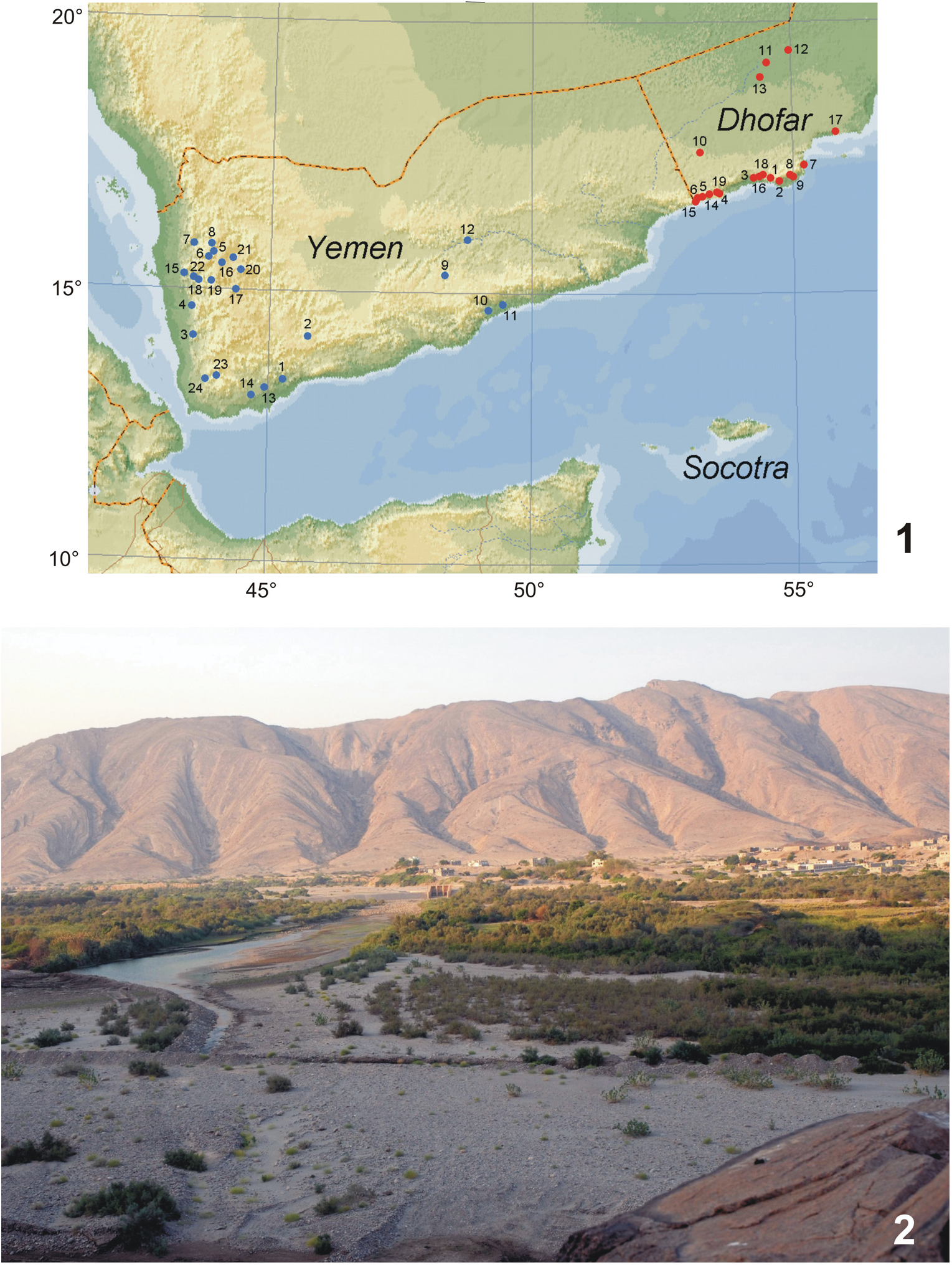
Material examined. OMAN: DHOFAR: 2 JJ, Al Mughsayl , 16°53ʹ46ʺN, 53°46ʹ24ʺE, 45 m, wadi, pools 2 km from seashore, 26.x.2009, A. Reiter leg. GoogleMaps ; 1 J, Jufa , haunt, 17°08ʹ15ʺN, 55°01ʹ41ʺE, 175 m, 29.x.2009, A. Reiter leg. (all NMPC) GoogleMaps ; 1 spec., 15 km W of Jufa ( Laga Shalia ), 17°11ʹ05ʺN, 54°56ʹ38ʺE, 380 m, 29.ix.2011, P. Kučera leg. ( PKCL) GoogleMaps ; 7 spec., same data, but 24.viii.2012 ( PKCL) GoogleMaps ; 1 spec., same data, but 13.iv.2013, R. Fouqué leg. ( JSCL) GoogleMaps ; 2 spec., same data, but 10.x.2013, P. Kučera leg. ( PKCL) GoogleMaps ; 2JJ, 13 km E Mirbat, wadi Ain , 17°01ʹN, 54°47ʹE, 59 m, 29.iii.2012, A. Reiter leg. ( NMPC) GoogleMaps ; 1 J, wadi Ash Shuwaymiyah , 17°56ʹN, 55°32ʹE, 31 m, 1.iv.2012, A. Reiter leg. ( NMPC) GoogleMaps ; 1 spec., Ajdarawt, wadi Ra’s Sajir , 30 m, 22.viii.2012, P. Kučera leg. ( PKCL) ; 3 spec., wadi Muqshin , 19°35ʹ06ʺN, 54°53ʹ04ʺE, 9.iv.2013, P. Kučera leg. ( PKCL) GoogleMaps . YEMEN: ABIJAN GOV.: 1 ♀, Ba Tays vill. env., wadi Bana , 13°20ʹ58ʺN, 45°17ʹ48ʺE, 168 m, 8.xi.2007, A. Reiter leg. HADRAMAUT GOV.: 5 JJ 1 ♀, N of Al Mukalla, Nueima, 14°36.4ʹN, 49°05.7ʹE, 279 m, 20.–21.x.2005, D. Král leg. GoogleMaps SOCOTRA ISLAND: 1 ♀, wadi Ayhaft , 12°36ʹ38ʺN, 53°58ʹ49ʺE, 190 m, 24.–26.xi.2003, P. Kabátek leg. GoogleMaps ; 1 J, same data, but 12°36.5ʹN, 53°58.9ʹE, pool, 200 m, 7.–8. xi.2010, J. Hájek leg. GoogleMaps ; 1 ♀, Homhil protected area, 12°34ʹ27ʺN, 54°18ʹ32ʺE, 364 m, 28.–29.xi.2003, P. Kabátek leg. GoogleMaps ; 2 JJ, 10 km E of Hadibo, Kam vill., 12°33ʹ42ʺN, 54°07ʹ05ʺE, 60 m, 5.v.2004, A. Reiter leg. GoogleMaps ; 1 J, Dixam plateau, Dixam lake , 12°31ʹ23ʺN 53°57ʹ12ʺE, 1000 m, 12.v.2004, A. Reiter leg. GoogleMaps ; 1 J 2♀♀, Dixam plateau, wadi Zerig , pools, Juncus marsh, 12°29.6ʹN, 53°59.5ʹE, 655 m, 13.–14.vi.2012, J. Bezděk, J. Hájek, V. Hula, P. Kment, I. Malenovský, J. Niedobová & L. Purchart leg. (all NMPC) GoogleMaps .
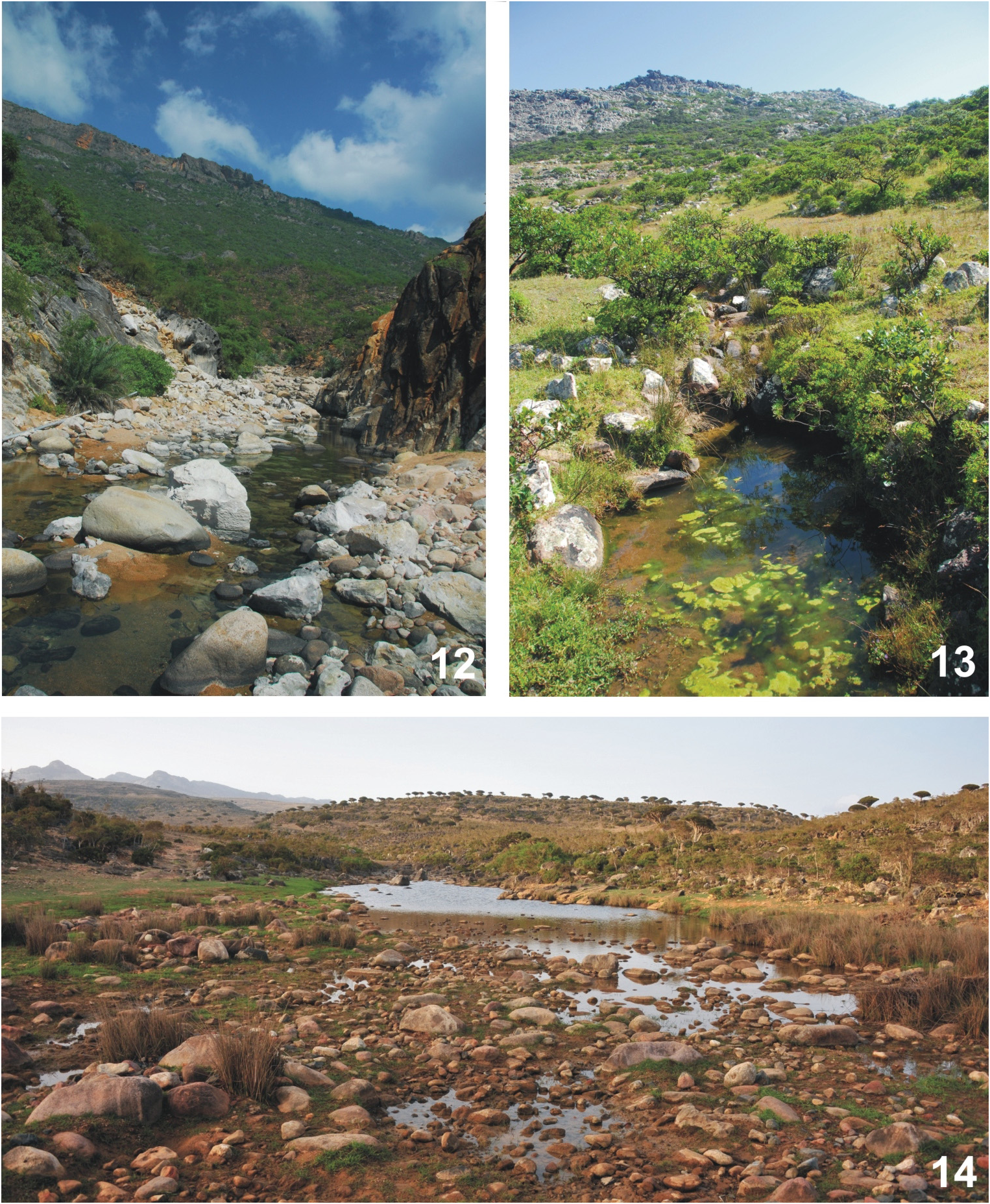
Habitat. Collected in various aquatic habitats, mostly larger pools both natural and manmade (e.g. Figs 2 View Figs 1–2. 1 , 14 View Figs 12–14 ); frequently attracted also to light traps. In the Arabian Peninsula so far not documented from higher altitudes.
Distribution. Cybister tripuncatus occurs in subtropical and tropical areas of the whole Old World. The subspecies C. t. africanus occurs in entire continental Africa, reaching south Europe in the north and Arabian Peninsula in the east ( GUIGNOT 1961).
| NMPC |
National Museum Prague |
No known copyright restrictions apply. See Agosti, D., Egloff, W., 2009. Taxonomic information exchange and copyright: the Plazi approach. BMC Research Notes 2009, 2:53 for further explanation.
|
Kingdom |
|
|
Phylum |
|
|
Class |
|
|
Order |
|
|
Family |
|
|
Genus |