
Teleorhinus cyaneus Uhler, 1890
|
publication ID |
https://doi.org/ 10.1206/3703.2 |
|
DOI |
https://doi.org/10.5281/zenodo.4574273 |
|
persistent identifier |
https://treatment.plazi.org/id/A87EAD38-FF0C-EB6E-F37B-3DB2FD4CFBEA |
|
treatment provided by |
Felipe |
|
scientific name |
Teleorhinus cyaneus Uhler |
| status |
|
Teleorhinus cyaneus Uhler View in CoL
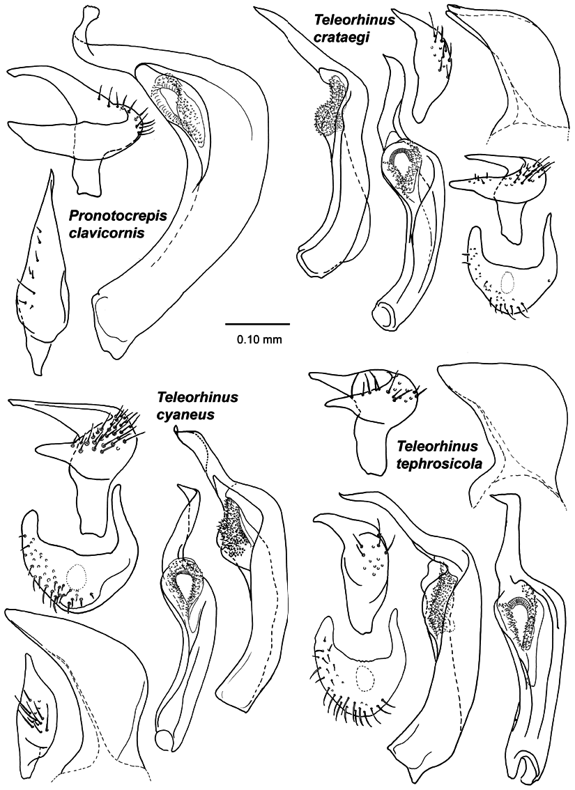
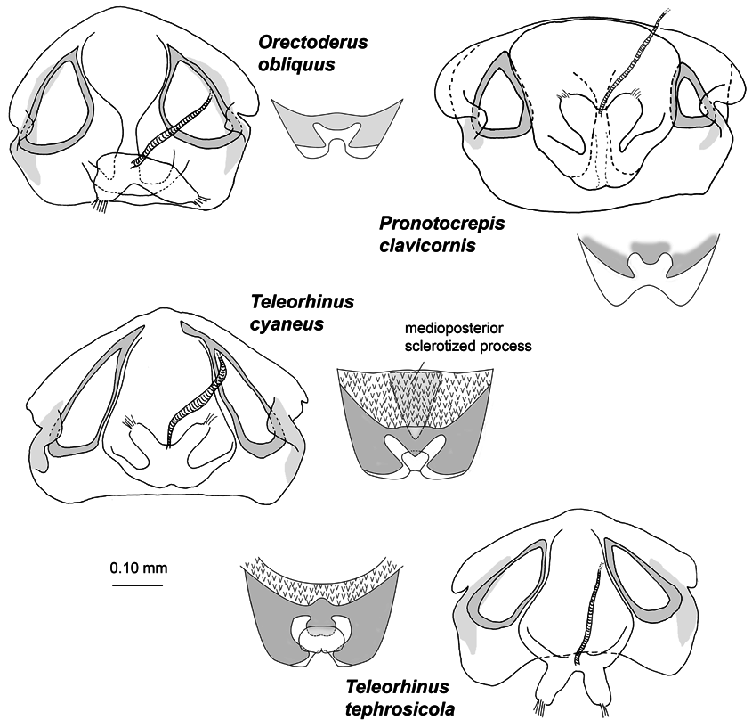
Figures 7 View FIGURE 7 , 9 View FIGURE 9 , 10 View FIGURE 10 , 11 View FIGURE 11 , 12 View FIGURE 12 ; map 5; table 3
Teleorhinus cyaneus Uhler, 1890: 75 View in CoL (new species, description); Kirkaldy, 1906: 128 (catalog); Van Duzee, 1916b: 42 (list); Carvalho, 1958: 180 (catalog); Knight, 1968b: 65, fig. 83 (diagnosis, distribution; fig. head and antenna); Wyniger et al., 2008: 339 (presence of brochosomes), 338, fig. 7C (detail of tarsus).
Teleorhinus brindleyi Knight, 1968b: 65 View in CoL (new species, description). NEW SYNONYMY.
Teleorhinus nigricornis Knight, 1968b: 66 View in CoL (new species, description). NEW SYNONYMY.
TYPE MATERIAL (EXAMINED): Teleorhinus cyaneus : LECTOTYPE: Female: [ USA] California: Los Angeles Co.: Los Angeles [34.05222°N 118.24278°W], Coquillett Collection , 1♀ ( AMNH _ PBI 00069002 View Materials ) ( USNM) GoogleMaps . PARALECTOTYPES: [ USA: California] Los Angeles Co.: Los Angeles [34.05222°N 118.24278°W], Coquillett Collection , 1♀ (00069003) ( USNM) GoogleMaps ; Los Angeles County [34.36667°N 118.2°W], 15 May 1900, 1♂ (00071969) ( CNC) GoogleMaps .
Teleorhinus brindleyi : HOLOTYPE: Female: [ USA: Idaho: Latah Co.] Moscow Mountain [46.80361°N 116.86778°W] 21 Jun 1936, T.A. Brindley ( AMNH _ PBI 00068999 View Materials ) ( USNM) GoogleMaps . PARATYPES: [ USA: Idaho: Kootenai Co.] Coeur d’Alene [47.67778°N 116.77944°W, 657 m] 26 Jun 1935, J.M. Beck, 1♀ (00071970) ( CNC). [Wyoming: GoogleMaps Sweetwater Co.] Farson, Big Sandy River [41.85151°N 109.78281°W] D. Elden Beck, 1♂ (00068786) ( USNM) GoogleMaps .
Teleorhinus nigricornis : HOLOTYPE: Female [ USA: Washington: Yakima Co.] Tieton Canyon [46.65217°N 120.7248°W] 21 Jun 1932, A.R. Rolfs ( AMNH _ PBI 00069000 View Materials ) ( USNM) GoogleMaps . ALLOTYPE:
[ Washington: Yakima Co.] Tieton Canyon [46.65217°N 120.7248°W] 21 Jun 1932, A.R. Rolfs, 1♂ (00068789) ( USNM). PARATYPE GoogleMaps : [ USA: California: Los Angeles Co.] Lake Tahoe [34.16531°N 117.67847°W] 10 Jun 1891, Coquillett, 1♂ (00071968) ( CNC) GoogleMaps .
DIAGNOSIS: Recognized by vesica beyond secondary gonopore shorter than in Teleorhinus crataegi and T. thephrosicola and bent just apically (fig. 9) and males more elongated than in T. crataegi and T. tephrosicola (fig. 9); inflated part of second antennal segment more than proximal half (fig. 7); second antennal segment more than twice as long as length of the pronotum (table 3); dull area below eye not recognized as band (fig. 7); phallotheca distinctly elongate, pointed (fig. 9); leπ paramere with anterior process rounded apically, posterior process rounded (fig. 9); right paramere straight (fig. 9); female distinguished from T. tephrosicola by shape of sclerotized rings of dorsal labiate plate (fig. 12) and posterior wall bearing medioposterior triangular sclerotized process caudally (fig. 12).
REDESCRIPTION: Male: Total length 7.74–8.23, length apex clypeus-cuneus fracture 5.42– 5.77, width across pronotum 1.73–1.78. COLORATION: Vertex sometimes brownish (fig. 7); labium black; coxae red-orange or whitish yellow with brown base; trochanter and femora bright red-orange; tibia more yellowish brown, dark brown basally; all tarsal segments brown. SURFACE AND VESTITURE: Very shining; dorsal surface including antennal segments clothed with short, black, reclining setae; dull appearing area below ventral margin of eye not recognizable as band (fig. 7); forefemora on inner surface with medial setae-free spots (fig. 10E). STRUCTURE: Rather elongate; labium surpassing mesocoxa; vertex with transverse carina. GENITALIA: Vesica simple, apical part beyond secondary gonopore bent, tapering into point (fig. 9); phallotheca distinctly elongate, pointed (fig. 9); leπ paramere with anterior process rounded apically, posterior process rounded (fig. 9); right paramere straight (fig. 9).
Female: Total length 5.91–6.42, length apex clypeus-cuneus fracture 4.60–5.09, width across pronotum 1.56–1.66. Coloration, surface, vestiture and structure as in males, except second antennal segment more widened distally; inflated distal part of second antennal segment more than half of the entire segment length (fig. 7); body more oval shaped than male. GENITALIA: Sclerotized rings of dorsal labiate plate ovoid, round apically (fig. 11); dorsal labiate plate bearing medioposterior triangular sclerotized process caudally; posterior wall with spinose field on surface; sclerotized part of posterior wall with triagular lobe medially (fig. 12).
HOSTS: Baccharis sp. ( Asteraceae ), Arctostaphylos sp. ( Ericaceae ), Lupinus sp., Melilotus officinalis (Fabaceae) , Ribes aurea (Grossulariaceae) , Pinus sp., P. ponderosa (Pinaceae) , Ceanothus cordulatus , C. cuneatus , C. integerrimus , C. rigidus , C. velutinus , Cercocarpus ledifolius , Rhamnus californica , R. crocea (Rhamnaceae) , Amelanchier utahensis , Cercocarpus ledifolius , C. montanus , Physocarpus capitatus , Prunus emarginata , P. subcordata , Purshia glandulosa , and P. tridentata (Rosaceae) .
DISTRIBUTION: Widely distributed in the western states, from British Columbia in the north to Baja California in the south.
DISCUSSION: Uhler (1890) described Teleorhinus cyaneus from two females taken in Los Angeles, California, without designating a holotype. The two female syntypes are housed in the collection of the USNM: one consists of the head with the right antenna consisting of the two segments, and the leπ antenna with three segments, the pronotum with forelegs, leπ, middle, and hind leg; glued on the point is a wing fragment. The second female lacks the head, pronotum, and the forelegs. The latter syntype is designated here as lectotype for stabilizing the nomenclature.
Knight (1968b) described Teleorhinus brindleyi based on two females and a male from Idaho and Wyoming; the holotype is a female. The second antennal segment of T. brindleyi was recorded by Knight (1968b) as bicolored with the base of the segment pale and the apical part darkened, whereas that segment in nigricornis , from California and Washington, appeared completely dark. My investigations of many specimens throughout the geographical range of the three nominal species indicates that the coloration of the second antennal segment is variable and shows no discernable geographical pattern. Base on this, the investigation of the holotype T. brindleyi , and the holotype and paratypes of T. nigricornis , I am treating the latter two names as junior synonyms of T. cyaneus , new synonymy.
SPECIMENS EXAMINED: CANADA: British Columbia: Manning Provincial Park, Blackwall, 49.08333°N 120.83333°W, 23 Jul 1970, L.A. Kelton, 1♀ (00071961) (CNC). Oliver, 49.18333°N 119.55°W, 02 Jul 1974, L.A. Kelton, Ceanothus sp. ( Rhamnaceae ), 1♂ (00071957), 3♀ (00071958–00071960) (CNC). Summerland, 49.56646°N 119.63951°W, 400 m, 02 Jul 1974 – 11 Jul 1974, L.A. Kelton, Ceanothus sp. ( Rhamnaceae ), 1♀ (00071962) (CNC). MEXICO: Baja California Norte: 15 mi E of Ensenada, 31.85378°N 116.39933°W, 09 Jun 1980, Brown and Faulkner, 3♀ (00074400–00074402) (SDNH). Parque Nacional Sierra San Pedro Martir, Corona Abajo, 30.73866°N 115.24664°W, 14 Jun 1961, E.L. Sleeper, 1♂ (00077158), 1♀ (00077263) (CAS). USA: Arizona: Apache Co. : near Alpine, 33.84806°N 109.1425°W, 27 May 1947, H. & M. Townes, 2♂ (00068806, 00068807) (USNM); 29 May 1947, H. & M. Townes, 1♂ (00068808) (USNM). California: Alpine Co.: 4 mi SE of Markleeville, 38.65398°N 119.72663°W, 2484 m, 10 Jun 1966, W. Gagne, 1♂ (00079150) (UCB). Alpine County, 38.6°N 119.8°W, 15 Jul 1934, J.E. Blum, 1♂ (00077183) (CAS). Woodfords, 38.77778°N 119.82083°W, 19 Jun 1958, R.P. Allen, 1♀ (00079174) (UCB). Just W of Monitor Pass on Rt 89, 38.67556°N 119.61944°W, 2549 m, 27 Jul 1999, M.D. Schwartz, Prunus subcordata Benth. (Rosaceae) , 1♀ (00071953) (CNC). Butte Co.: Big Bend Mountain, 39.69722°N 121.44639°W, 28 May 1928, H.H. Keifer, Ceanothus integerrimus (Rhamnaceae) , 1♀ (00077204) (CAS). Calaveras Co.: Camp Cornell Maintenance Camp, Stanislaus National Forest on Rt 4, 38.00222°N 120.13611°W, 05 Jul 1994, M.D. Schwartz, Ceanothus integerrimus H. and A. ( Rhamnaceae ), 2♂ (00071946, 00071947), 4♀ (00071948–00071951) (CNC). El Dorado Co.: Echo Lake, 38.83389°N 120.04056°W, 21 Jul 1948, A. Bartel, 1♂ (00079157) (UCB). Eldorado National Forest, Silver Creek Campground, 38.75°N 120.33416°W, 1620 m, 05 Jun 1973 – 06 Jun 1973, D.K. & D.C. Young, 1♂ (00086412), 1♀ (00086413) (MSU). Fallen Leaf, 38.88306°N 120.07167°W, 03 Jul 1935, F.E. Blaisdell, 1♂ (00077177) (CAS); 15 Jul 1931, O.H. Swezey, 1♂ (00077194) (CAS). Fallen Leaf Lake, Lake Tahoe, 38.92167°N 120.06167°W, 12 Jul 1915, E.C. Van Dyke, 1♀ (00077178) (CAS). Pollock pines, 38.76139°N 120.58556°W, 25 Jun 1948, N.D. Waters, 2♂ (00071971, 00071972) (CNC). Pyramid B.S., El Dorado county, 38.76667°N 120.51667°W, 12 Jul 1948, R.C. Bynum, Ceanothus sp. ( Rhamnaceae ), 1♂ (00079148) (UCB). Snowline Camp, 38.74639°N 120.62333°W, 21 Jun 1948, O.E. Myers, Lupinus sp. ( Fabaceae ), 1♀ (00075975), 1 nymph (00075974) (ORSU); 21 Jun 1948, K.W. Tucker, 1♀ (00079170) (UCB). Fresno Co.: Huntington Lake, 37.23389°N 119.21194°W, 2134 m, 23 Jul 1919, E.P. Van Duzee, 1♀ (00077199) (CAS). Paradise Valley, Kings River, 36.98927°N 118.59725°W, 2134 m, 23 Jul 1910, E P. Van Duzee, 1♀ (00077198) (CAS). Pinehurst, 36.69528°N 119.01556°W, 07 Jun 1935, A.L. Melander, 2♀ (00058578, 00058579) (AMNH). Glenn Co.: Paskenta Mountain, 39.78763°N 122.53902°W, 02 Jun 1987, J.D. Pinto, 1♀ (00082504) (UCR). Inyo Co. : 10 mi NW Bishop, 37.46607°N 118.52317°W, 30 Jun 1961, G.W. Frankie, 1♀ (00079172) (UCB). 7 mi N of Parchers Camp, 37.28702°N 118.55694°W, 30 Jun 1961, J.K. Drew, 1♀ (00077197) (CAS). Wyman Canyon, White Mountains, 37.442°N 118.17895°W, 2591 m, 27 Jun 1961, J.K. Drew, 1♂ (00077195) (CAS). Kern Co.: 13 mi E of Onyx Walkers Pass, 35.69005°N 117.98755°W, 26 May 1946, J.J. du Bois, 1♂ (00079151), 1♀ (00079152) (UCB). Lassen Co.: Susanville, 40.41639°N 120.65194°W, 17 Jun 1959, Kelton and Madge, greasewood, 3♀ (00071963–00071965) (CNC). Los Angeles Co.: Claremont, 34.09667°N 117.71889°W, 11 May 1930, unknown, Rhamnus crocea (Rhamnaceae) , 1♂ (00082495) (UCR). Los Angeles, 34.05222°N 118.24278°W, Coquillett Collection, 1♀ (00068989) (USNM). Los Angeles County, 34.36667°N 118.2°W, 15 Jun 1900, unknown, 1♂ (00068794) (USNM); 15 May 1900, unknown, 1♀ (00068796) (USNM). Mint Canyon, 34.41528°N 118.45278°W, 26 May 1937, E.P. Van Duzee, 1♂ (00077185), 1♀ (00077200), 1 nymph (00077196) (CAS). Saugus 5 mi E Mint Canyon, 34.41139°N 118.53917°W, 20 Apr 1932, E P. Van Duzee, 3♂ (00077167–00077169), 2♀ (00077170, 00077171) (CAS). Madera Co. : Bass Lake, 37.32472°N 119.56528°W, 914 m, 03 Jun 1942, Arthur J. Walz, Ceanothus sp. ( Rhamnaceae ), 1♂ (00079409) (UCB). Madera County , 37.16667°N 119.83333°W, 27 Jul 1946, T.O. Thatcher, Ceanothus sp. ( Rhamnaceae ), 2♀ (00079166, 00079173) (UCB). North Fork, 22 Apr 1934, unknown, 1♀ (00079165) (UCB). Oakhurst, 37.32806°N 119.64833°W, 26 May 1942, J.T. Polhemus, Ceanothus sp. ( Rhamnaceae ), 1♀ (00086635) (UID). Mariposa Co. : Yosemite National Park, 37.85°N 119.56667°W, 1201 m, 08 Jun 1931, unknown, 1♀ (00079145) (UCB); 15 Jun 1931, unknown, 1♂ (00079146) (UCB); 07 Jun 1931, E.O. Essig, 1♂ (00079147) (UCB); 20 May 1931, D.W. Clency, 1♀ (00082505) (UCR). Modoc Co.: Davis Creek, Warner Mountains, 41.73619°N 120.34146°W, 17 Jul 1922, C.L. Fox, 1♂ (00077191) (CAS). Fandango Pass Summit, 41.80222°N 120.20583°W, 1890 m, 03 Jul 1979, R.T. Schuh and B.M. Massie, Cercocarpus ledifolius (Rosaceae) , 1♂ (00059314) (AMNH). Mono Co.: 7 mi E Bodie, 38.22744°N 118.90982°W, 01 Jul 1964, P. Rude, 1♂ (00079149), 1♀ (00079168) (UCB). Cloudburst Creek Camp, 38.34333°N 119.54111°W, 18 Jun 1959, F.M. Beer, 1♂ (00075955) (ORSU). Leavitt Meadows, 38.3175°N 119.55028°W, 05 Jul 1962, R P. Allen, 1♂ (00073783) (CAFA). Lee Vining, 37.9575°N 119.12083°W, 24 Jun 1948, H.K. Townes, 1♀ (00068800) (USNM). Lee Vining, 37.9575°N 119.12083°W, 05 Jul 1962, R.P. Allen, 1♂ (00073784) (CAFA). Sonora Pass, 38.32778°N 119.63583°W, 28 Jul 1963, W.F. Chamberlain, 1♂ (00058087) (TAMU). Toms Place, 37.56139°N 118.68028°W, 06 Jul 1965, C.D. Johnson, Light Trap, 1♂ (00079153) (UCB). Twin Lakes, 37.61806°N 119.00694°W, 15 Jul 1929, unknown, 1♀ (00068799) (USNM). Monterey Co.: King City, 36.21278°N 121.125°W, 03 May 1974, J. Doyen, 1♀ (00079158) (UCB). Paraiso Hot Springs, Bryant Lot 63, 38.77028°N 119.71556°W, 15 Jun 1954, unknown, Baccharis sp. ( Asteraceae ), 1♀ (00077202) (CAS). Salinas River at King City, 36.20083°N 121.13495°W, 03 May 1974, J. Powell, Ribes aurea (Grossulariaceae) , 8♀ (00079120–00079127) (UCB). Nevada Co.: Sagehen Creek Station near Hobart Mills, 39.4323°N 120.19859°W, 01 Jul 1964, C.N. Slobodchikoff, 1♂ (00077188) (CAS). Truckee, 39.32806°N 120.18222°W, 05 Jul 1927, E.P. Van Duzee, 1♂ (00077182) (CAS). Plumas Co.: Almanor, 40.2175°N 121.17306°W, 24 Jun 1937, B.P. Bliven, 1♀ (00077207) (CAS). Chester, 40.30639°N 121.23083°W, 26 Jun 1937, B.P. Bliven, 2♀ (00077175, 00077176) (CAS). Johnsville, 39.76083°N 120.69444°W, 25 Jul 1967, Helena Pini, Light Trap, 4♂ (00075947–00075950) (ORSU). Lake Almanor, 40.25278°N 121.16028°W, 07 Jul 1952, M. Cazier, W. Gertsch, and R. Schrammel, 1♀ (00058587) (AMNH). Quincy, 14 mi W., 39.93694°N 120.94611°W, 11 Jul 1965, W. Tuner, 1♀ (00079155) (UCB). Riverside Co.: 2 mi Poppet Flat, San Jacinto Mountains, 33.78389°N 116.95778°W, 1524 m, 01 Jun 1940, unknown, Ceanothus sp. ( Rhamnaceae ), 1♂ (00079408) (UCB). 2 mi Poppet Flat, San Jacinto Mts., 33.78389°N 116.95778°W, 01 Jun 1949, D.J. Raski, Ceanothus sp. ( Rhamnaceae ), 1♂ (00079143) (UCB). 2 mi SE Poppet Flat, San Jacinto Mts., 33.82947°N 116.82696°W, 1524 m, 01 Jun 1940, unknown, Ceanothus sp. ( Rhamnaceae ), 1♂ (00079144) (UCB). 2 mi SE Poppet, San Jacinto Mountains, 33.76336°N 116.93309°W, 01 Jun 1940, unknown, Ceanothus sp. ( Rhamnaceae ), 1♀ (00077206) Rhamnus sp. ( Rhamnaceae ), 1♀ (00077203) (CAS). Beaumont, 33.92944°N 116.97639°W, 19 Jun 1909, E.D. Ball, 1♂ (00068791) (USNM). Dark Creek, San Jacinto Mountains, 33.79305°N 116.74583°W, 21 Jul 1940, unknown, Rhamnus californica (Rhamnaceae) , 1♀ (00082497) (UCR). Gavilan, 33.78444°N 117.36916°W, 12 May 1950, unknown, Rhamnus crocea (Rhamnaceae) , 4♂ (00082489–00082490, 00082492, 00082496), 1♀ (00082500) (UCR); 07 May 1951, unknown, Rhamnus crocea (Rhamnaceae) , 2♂ (00082491, 00082493), 2♀ (00082499, 00082501) (UCR); 14 May 1948, unknown, Rhamnus crocea (Rhamnaceae) , 1♂ (00082494) (UCR). Hurkey Creek P.C. San Jacinto Mountains, 21 Jun 1960, E.L. Sleeper, 1♂ (00077157) (CAS). Idyllwild, San Jacinto Mountains, 33.78389°N 116.95778°W, 17 Jun 1940, unknown, Ceanothus sp. ( Rhamnaceae ), 1♀ (00077201) (CAS). Poppet Flat, 33.85°N 116.85167°W, 01 Jun 1940, R.L. Usinger, 1♂ (00079159), 1♀ (00079162) (UCB); 01 Jun 1940, unknown, 1♂ (00079160), 1♀ (00079161) (UCB). Riverside, 33.95333°N 117.39528°W, 02 May 1935, C.M. Dammers, 1♂ (00077184) (CAS). San Bern. Nat. Forest, Thomas Mountain, T6S R3E S16, 33.61972°N 116.67944°W, 1320 m, 06 May 1997, H.W. Park, 1♂ (00082488) (UCR). San Jacinto Mts., 2.5 mi SE Poppet Flat, 33.82434°N 116.82078°W, 02 Jun 1940, H.T. Reynolds, Ceanothus sp. ( Rhamnaceae ), 1♂ (00079138), 2♀ (00079139, 00079140) (UCB). San Jacinto River Canyon, San Jacinto Mountains, 33.78389°N 116.95778°W, 30 May 1940, D.J. Raski, 1♀ (00079156) (UCB). San Bernardino Co.: Jct I-15 & Rt 138, 34.31229°N 117.47513°W, 1250 m, 26 Jun 1980, R.T. Schuh, Rhamnus crocea Nutt. (Rhamnaceae) , det. B. Ertter, 2♀ (00058520, 00058521) (AMNH). Mill Creek, San Bernardino Mountains, 34.0835°N 116.89461°W, 30 Jun 1936, unknown, Rhamnus californica (Rhamnaceae) , 1♀ (00082498) (UCR). Mojave R. Forks Hesperia, 10 km SE, 34.42639°N 117.3°W, 06 May 1986, Tadashi Nitta, 1♂ (00082487) (UCR). Ontario, San Antonia Canyon, 34.06406°N 117.65289°W, 25 Jul 1907, unknown, 1♀ (00068793) (USNM). San Bernardino, 34.08861°N 117.27972°W, 28 Apr 1971, E.L. Paddock, Ceanothus rigidus (Rhamnaceae) , 1♂ (00073776), 1♀ (00073777), 5 nymphs (00073778– 00073782) (CAFA). Ceanothus rigidus (Rhamnaceae) , 1♂ (00068784), 1♀ (00068785) (USNM). San Diego Co.: 1 mi W of Mt. Palomar, 38.3605°N 116.8724°W, 23 Jun 1962, J.F. Lawrence, 1♀ (00079137) (UCB). Morena Dam, 32.78083°N 117.20694°W, 26 May 1929, C.C. Sarl, 1♂ (00075954) (ORSU). Mount Laguna, 32.87222°N 116.4175°W, 21 Jun 1963, J. Powell, Ceanothus integerrimus (Rhamnaceae) , 1♀ (00079164) (UCB); 21 Jun 1963, H.L. Griffin, 1♀ (00079163) (UCB). Palomar Mountain, 33.36333°N 116.83528°W, 28 Jun 1963, J. Powell, 1♂ (00079141) Prunus emarginata (Rosaceae) , 2♂ (00079135, 00079136), 2♀ (00079130, 00079131) (UCB); 28 Jun 1963, C.H. Frady, 1♀ (00075968) (ORSU); 28 Jun 1963, N. Sakdapolrak, 1♂ (00079134), 4♀ (00079128–00079129, 00079132–00079133) (UCB). San Diego, 32.71528°N 117.15639°W, 28 Apr 1935, C.M. Dammers, 1♂ (00077159) (CAS). San Luis Obispo Co.: Tassajara Creek 7 mi N San Luis Obispo, 35.37986°N 120.6601°W, 04 Jun 1971 – 05 Jun 1971, J.D. Pinto, 1♂ (00082502), 1♀ (00082503) (UCR). Santa Barbara Co.: Figueroa Park, Santa Barbara National Forest, 34.43726°N 119.70513°W, 03 Jun 1919, Ralph Hopping, 1♂ (00077190) (CAS). Santa Clara Co.: S end of Mines Road, Santa Clara County, 37.35417°N 121.95417°W, 716 m, 23 Apr 1972, H.B. Leach, Ceanothus cuneatus (Rhamnaceae) , 5♂ (00077160–00077164), 2♀ (00077165, 00077166) (CAS). Shasta Co.: 13 mi E Bartle, 41.12751°N 121.64056°W, 1237 m, 09 Jul 1980, G.M. Stonedahl, Ceanothus integerrimus (Rhamnaceae) , 1♀ (00075960) (ORSU). 15 mi S McCloud, 41.03846°N 122.13833°W, 15 Jun 1975, R. Preserve, A.E. Hajek, 1♀ (00079180) (UCB). 3 mi East Lake Eiler, 37.17806°N 119.02611°W, 22 Jul 1947, T.F. Leigh, 1♀ (00079179) (UCB). 7.6 mi N of Manton, 40.54515°N 121.86889°W, 1138 m, 10 Jul 1980, G.M. Stonedahl, Arctostaphylos sp. ( Ericaceae ), 1♀ (00058582) (AMNH). Lassen Volcanic National Park, base of Summit Trail, 40.48111°N 121.38222°W, 2591 m, 16 Jul 1979, J.M. & J.M. Campbell, 1♀ (00071954) (CNC). Siskiyou Co.: 2 mi W of McCloud, 41.25583°N 122.17679°W, 1143 m, 26 Jun 1981, J.D. Lattin, 1♀ (00075958) (ORSU). 3.7 mi W of McCloud, 41.25583°N 122.20948°W, 1390 m, 09 Jul 1980, R.T. Schuh and G.M. Stonedahl, Ceanothus cordulatus Kell. (Rhamnaceae) , det. J. Grimes, 1980, 2♂ (00058504, 00058505), 4♀ (00058506–00058509), 2 nymphs (00058510, 00058511) (AMNH); 09 Jul 1980, G.M. Stonedahl, Ceanothus sp. ( Rhamnaceae ), 1♀ (00075959) (ORSU). 4 mi E Mt. Shasta PO on Hwy. 89, 40.59941°N 122.41448°W, 1250 m, 22 Jun 1981, J.D. Lattin, Pinus ponderosa (Pinaceae) , 1♂ (00075957) (ORSU). 4 road mi E of Shasta City, McBride Cmpgd, 40.59944°N 122.49083°W, 23 Jul 1962, D.C. Rentz and C.D. MacNeill, 1♂ (00077187) (CAS). 5 mi E of McCloud, 41.25579°N 122.04195°W, 07 Jul 1957, J. Powell, 1♀ (00079167) (UCB). 5 mi S of Weed, 41.35609°N 122.36048°W, 15 Jun 1959, Kelton and Madge, 2♂ (00071966, 00071967) (CNC). 5.4 mi W McCloud on Hwy 89, 41.25578°N 122.24241°W, 09 Aug 1980, G.M. Stonedahl, Ceanothus sp. ( Rhamnaceae ), 1♀ (00058581) (AMNH). Ash Creek Ranger Station, 9 mi E McCloud, 41.2975°N 121.94216°W, 1067 m, 07 Jun 1974 – 09 Jun 1974, J. Doyen, Ceanothus cordulatus (Rhamnaceae) , 1♀ (00079171) (UCB). Black Butte Summit, 8 mi S of Weed, 41.30712°N 122.385°W, 1189 m, 22 May 1981, Lattin, 1♀ (00075962) (ORSU). McCloud, 41.25583°N 122.13833°W, 1090 m, 09 Jul 1980, G.M. Stonedahl, Ceanothus sp. ( Rhamnaceae ), 1♀ (00075965) (ORSU). McCloud, 41.25583°N 122.13833°W, 22 Jun 1914, E.C. Van Dyke, 1♂ (00068788) (USNM). Mount Shasta, 41.31°N 122.30944°W, 01 Jul 1975, E. Paddock, Pinus sp. ( Pinaceae ), 2♂ (00075951, 00075952) (ORSU). Mount Shasta City, 41.31°N 122.30944°W, 20 Jun 1958, J. Powell, 1♂ (00079142) (UCB). Mount Shasta City, 41.31°N 122.30944°W, 30 Jun 1937, B.P. Bliven, 1♂ (00077260), 1♀ (00077261) (CAS). Shasta Springs, 40.59944°N 122.49083°W, 19 Jun 1920, C.L. Fox, 2♂ (00077186, 00077192) (CAS). Snowman’s Hill Summit, 5 mi E McCloud, 41.25579°N 122.04195°W, 1320 m, 13 Jun 1974, J. Powell, Arctostaphylos sp. ( Ericaceae ), 1♂ (00079177) (UCB). Young’s Valley, Siskiyou county, 41.58333°N 122.51667°W, 1402 m, 03 Aug 1971, M. Butler, Physocarpus capitatus (Rosaceae) , 1♀ (00075964) (ORSU). Yreka, 41.73556°N 122.63333°W, 12 Jun 1975, P. Oman, 1♀ (00075961) (ORSU). Stanislaus Co.: Del Puerto Cyn. Frank Raines Reg. Ok. Deer Tree Camp, 38.00222°N 120.13611°W, 22 May 1976, R. Kawin, 1♀ (00077262) (CAS). Trinity Co.: Coffee Creek, 41.10157°N 122.77786°W, 21 Jun 1934, G. & R. Bohart, 1♂ (00077189) (CAS). Hayfork Ranger Station, 40.55444°N 123.18194°W, 701 m, 23 May 1973, J. Powell, 1♀ (00079169) (UCB). Mountain Mdw. Rch. head Coffee Cr., 41.10306°N 122.77694°W, 1554 m, 08 Jul 1969, J. Powell, 1♀ (00079178) (UCB). Tuolumne Co.: Deadman Creek just E of vista point on Rt 108, 38.31292°N 119.74702°W, 2799 m, 27 Jul 1999, M.D. Schwartz, Prunus subcordata Benth. (Rosaceae) , 1♀ (00071952) (CNC). Pinecrest, 38.18861°N 119.98972°W, 05 Jul 1942, R.E. Beer, 2♂ (00074874, 00074882) (KU). Strawberry, municipality of, 38.19833°N 120.00833°W, 15 Aug 1962, C. A Toschi, 1♀ (00079175) (UCB). Colorado: Denver Co.: Denver, 39.73917°N 104.98417°W, 15 Jul 1900, N. Banks, 1♂ (00058522) (AMNH). Larimer Co.: 1 mi S of Poudre River on Pingree Park Road, 37 mi W of Fort Collins, 40.58313°N 105.78997°W, 2103 m, 14 Jul 1986, R.T. Schuh and J.T. Polhemus, Cercocarpus montanus Raf. (Rosaceae) , 1♂ (00058562), 8♀ (00058563–00058570) (AMNH). Fort Collins, 40.58528°N 105.08389°W, 12 Jun 1900, unknown, 1♀ (00071973) (CNC). 1♂ (00068787) (USNM). Pingree Park road at jct. w. Colo. 14, 40.56111°N 105.59722°W, 14 Jul 1986, J.T. and D.A. Polhemus, Cercocarpus montanus (Rosaceae) , 3♀ (00063506–00063508) (JTP). Idaho: Butte Co.: Craters of the Moon National Monument, 43.42972°N 113.53056°W, 13 Jul 1965, D.S. Horning, Jr., Melilotus officinalis (Fabaceae) , 1♂ (00068803) (USNM). Camas Co.: Fairfield, 43.34667°N 114.79083°W, 24 Jun 1976, Knowlton, Cazier, 1♂ (00075355), 1♀ (00075354) (USU). Caribou Co.: Pine Bar Campground, 1 mi E Wayan on ID St rt 34, 42.97832°N 111.3563°W, 1829 m, 30 Jul 1981, M.D. Schwartz, Purshia tridentata (Rosaceae) , 2♀ (00058583, 00058590) (AMNH). Franklin Co.: Cub River Canyon, 42.13601°N 111.69891°W, 26 Jun 1971, G.F. Knowlton and S.G. Cazier, 2♀ (00075352, 00075353) (USU). Idaho Co.: 20.7 mi WSW Lolo Pass, Squaw Creek, 45.41806°N 116.42366°W, 960 m, 22 Jul 1978, Nancy L. Herman, 1♀ (00058580) (AMNH). Latah Co.: Cedar Mountain, Moscow, 46.73112°N 117.00216°W, 06 Jul 1922, M.C. Lane, 1♂ (00068790) (USNM). Moscow Mountain, 46.80361°N 116.86778°W, 31 Jul 1972, L.A. Kelton, Ceanothus sp. ( Rhamnaceae ), 2♀ (00071955, 00071956) (CNC). Oneida Co. : 5 mi NW of Holbrook, 42.21305°N 112.72206°W, 08 Jan 1972, G.F. Knowlton, 1♀ (00079176) (UCB). Owyhee Co.: Silver City, 43.01694°N 116.73222°W, 1890 m, 08 Jul 1973, P.W. Oman, 1♀ (00075966) (ORSU). Nevada: Carson City Co.: Carson City, 39.16389°N 119.76639°W, 1829 m, 26 Jun 1929, R.L. Usinger, 2♂ (00077172, 00077173), 3♀ (00077179–00077181) gooseberry, 1♀ (00077174) (CAS). Mineral Co.: 27 mi SW of Hawthorne on Rt 359, 1 mi NE of Anchorite Summit, 38.24871°N 118.97506°W, 2256 m, 02 Jul 1983, R. Schuh, M.D. Schwartz, Purshia glandulosa Curran (Rosaceae) , 11♂ (00058532–00058541, 00095990), 21♀ (00058542–00058561, 00095991) (AMNH). Washoe Co.: Peavine Mountain, 39.58556°N 119.93°W, 25 Jun 1986, J.B. Knight, Ceanothus velutinus Dougl. ex Hook (Rhamnaceae) , 1♀ (00058519) (AMNH). Sooner Pass, 40.54347°N 119.97753°W, 1783 m, 12 Jul 1972, Oman, 1♂ (00075953) (ORSU). Oregon: Clackamas Co.: Mount Hood, 45.53806°N 121.56722°W, 1372 m, 26 Jun 1925, E.C. Van Dyke, 1♂ (00077193) (CAS). Deschutes Co.: 2 mi West of Paulina Lake, 43.72027°N 121.2948°W, 26 Jul 1939, Gray and Schuh, 1♀ (00058585) (AMNH). La Pine, 44.86139°N 117.08806°W, 02 Jul 1935, R.H. Beamer, 1♂ (00074881), 1♀ (00074884) (KU). Three Sisters Wilderness, T16 R8E Sec33, on snowfield on Middle Sister, 44.12987°N 121.7655°W, 2743 m, 29 Jul 1980, M.D. Schwartz, 2♀ (00058575, 00058576) (AMNH). Jackson Co.: Siskiyou Pass, 42.05056°N 122.60167°W, 08 Jul 1970, R.L. Westcott, 1♀ (00075963) (ORSU). Josephine Co.: 1 mi S of Rough and Ready Botanical Wayside, 42.08324°N 123.69209°W, 12 Jul 1979, M.D. Schwartz, Lupinus sp. ( Fabaceae ), 1♀ (00058588) (AMNH). Klamath Co.: 16 mi E of Dairy on Rt 140, 04 Jul 1982, T.J. Henry and G.M. Stonedahl, Cercocarpus ledifolius (Rosaceae) , 3♀ (00177757– 00177759) (USNM). Klamath Falls area above Geary Ranch, 42.28319°N 121.89225°W, 26 Jun 1959, Joe Schuh, 1♀ (00068995) (USNM). Siskiyou Summit on I5, 42.075°N 122.60583°W, 04 Jul 1982, G.M. Stonedahl and T.J. Henry, Ceanothus integerrimus H. and A. ( Rhamnaceae ), 1♀ (00058577) (AMNH). Union Creek, Crater Lake, 42.94389°N 122.10556°W, 03 Jul 1952, M. Cazier, W. Gertsch, and R. Schrammel, 1♀ (00058584) (AMNH). Lake Co.: 15 mi SW Silver Lake T29S, R12E, S28, 42.97422°N 121.25552°W, 24 Jul 1957, G.F. Kraπ, Cercocarpus ledifolius (Rosaceae) , 1♀ (00075967) (ORSU). 28 mi SE Jct 97 & 31, 43.3766°N 121.20966°W, 1497 m, 25 Jul 1979, M.D. Schwartz, Cercocarpus ledifolius (Rosaceae) , 2♀ (00058523, 00058524) (AMNH); 25 Jun 1979, G.M. Stonedahl, Cercocarpus ledifolius (Rosaceae) , 2♂ (00075969, 00075970), 3♀ (00075971–00075973) (ORSU). 28 mi SE of La Pine on Rt 31, 43.3766°N 121.20966°W, 1535 m, 25 Jun 1979, R.T. Schuh, Cercocarpus ledifolius (Rosaceae) , 1♀ (00058586) (AMNH). Linn Co.: Hoodoo Ski Bowl, 44.40917°N 121.87333°W, 1402 m, 25 Jul 1966, J. Powell, 1♀ (00079154) (UCB). Union Co.: 14 mi S of Union, 45.00621°N 117.86417°W, 1280 m, 30 Jun 1960, J.D. Lattin, Ceanothus velutinus (Rhamnaceae) , 2♀ (00075976, 00075977) (ORSU). Wheeler Co.: 4.5 mi S of Mitchell on Summit Prairie Road, 44.50161°N 120.15222°W, 22 Jun 1979, M.D. Schwartz, Ceanothus ledifolius (Rhamnaceae) , 3♂ (00058512–00058514), 3♀ (00058515–00058517) (AMNH). Utah: Box Elder Co. : Blue Creek, 41.86215°N 112.45691°W, 1432 m, 14 Jun 1932, G.F. Knowlton, 1♂ (00075351) (USU). Garfield Co.: Bryce Canyon National Park, 37.58333°N 112.21667°W, 06 Jun 1969, W.F. Chamberlain, 1♂ (00058088) (TAMU). Juab Co.: Kyne, Utah Agriculture Experiment Station, 39.64528°N 111.86917°W, 17 Jun 1933, G.F. Knowlton, 1♀ (00068797) (USNM). Sanpete Co.: Cottonwood creek 4.7 mi NE Fairview on 31, 0.5 mi W Nat’l For. Bd., 39.64849°N 111.38515°W, 2134 m, 12 Jul 1981, M.D. Schwartz, Amelanchier utahensis (Rosaceae) , 2♂ (00058518, 00058574) (AMNH). Sevier Co.: Fish Lake, 38.56419°N 111.70611°W, 16 Aug 1929, R.H. Beamer, 1♀ (00074883) (KU). Washington: Klickitat Co.: 20 mi NE Goldendale, 46.02521°N 120.52673°W, 853 m, 12 Jun 1973, Oman and Musgrave, 1♂ (00075956) (ORSU). Wyoming: Lincoln Co.: Salt River Pass, 15 mi S of Aπon on Rt 89, 42.54234°N 110.89431°W, 2326 m, 21 Jul 1981, M.D. Schwartz, Ceanothus velutinus Dougl. (Rhamnaceae) , 1♂ (00005871), 2♀ (00005872, 00005873) (AMNH).


No known copyright restrictions apply. See Agosti, D., Egloff, W., 2009. Taxonomic information exchange and copyright: the Plazi approach. BMC Research Notes 2009, 2:53 for further explanation.
|
Kingdom |
|
|
Phylum |
|
|
Class |
|
|
Order |
|
|
Family |
|
|
Genus |
Teleorhinus cyaneus Uhler
| Wyniger, Denise 2010 |
Teleorhinus brindleyi
| Knight, H. H. 1968: 65 |
Teleorhinus nigricornis
| Knight, H. H. 1968: 66 |
Teleorhinus cyaneus
| Wyniger, D. & D. Burckhardt & R. Muhlethaler & D. Mathys 2008: 339 |
| Knight, H. H. 1968: 65 |
| Carvalho, J. C. M. 1958: 180 |
| Van Duzee, E. P. 1916: 42 |
| Kirkaldy, G. W. 1906: 128 |
| Uhler, P. R. 1890: 75 |