
Talinella humbertii Appleq., 2005
|
publication ID |
https://doi.org/ 10.5281/zenodo.5370864 |
|
persistent identifier |
https://treatment.plazi.org/id/0396CE4A-FF89-FFD8-FFD7-F07AFCE7FBEC |
|
treatment provided by |
Marcus |
|
scientific name |
Talinella humbertii Appleq. |
| status |
sp. nov. |
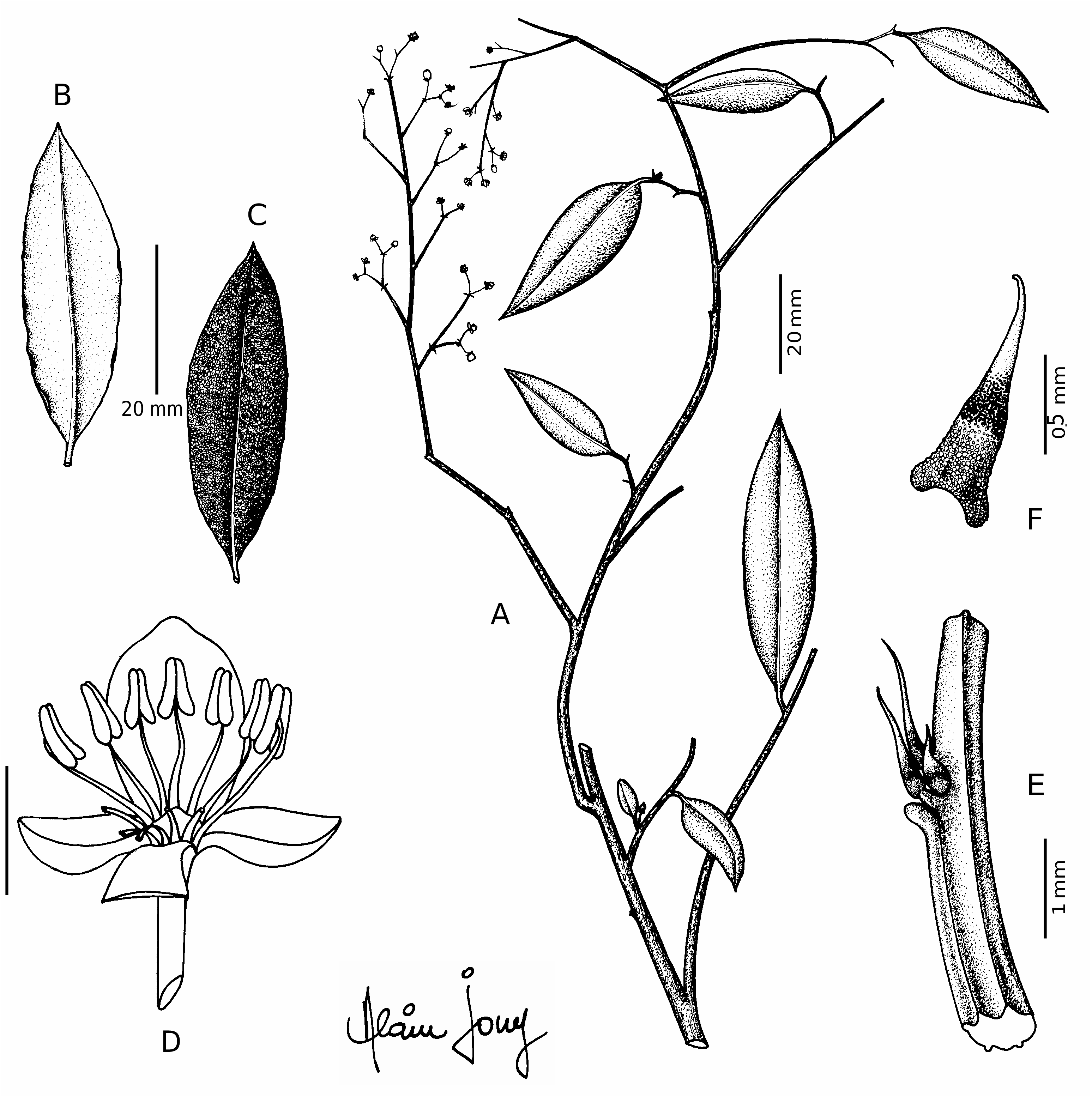
7. Talinella humbertii Appleq. View in CoL , sp. nov.
Haec species a Talinella dauphinensis Scott-Elliot foliis minoribus lanceolatis, ramunculis plerumque papillosis papillis albis et bruneis, squamis gemmae foliaris pluries usque ad 1 mm longis apice recurvato pallido, sepalis aequalibus, petalis 2 2. 0-2.5 mm longis atque stigmatibus non papillosis differt.
TYPUS. — Humbert 13403, Prov. Toliara, vallée de la Sakamalio, affluent de la Manambolo (bassin du Mandrare), pentes rocailleuses (gneiss), 900-1100 m, 24°32’S, 046°41’E, fl., Dec. 1933 (holo-, P!; iso-, P!) GoogleMaps .
Shrub, sarmentose to lianoid, 6-10 dm high. Twigs straight to contorted, slender, reddish brown to dull brown, often with plentiful pale, round to elliptical lenticels; small twigs papillose with white and brown papillae or glabrous. Leaves lanceolate to elliptical or ovate, 1.2- 7.0(-9.0) cm long, 0.4-2.0(-3.5) cm broad, sometimes slightly asymmetrical, membraneous to thick and coriaceous when dried, often bullate; apex acute, asymmetrically short-apiculate, or occasionally rounded, sometimes minutely emarginate or mucronulate; base rounded-tapering to rounded; midrib conspicuous beneath, secondary venation invisible or inconspicuous. Inflorescences terminal, open, small with few maturing flowers; peduncle and rachis filiform, whitepapillate or glabrous; bud scales near base of peduncle sometimes 0.6-1.0(-1.6) mm long, acuminate, recurved, with pale apex, otherwise dark, triangular; bracts 0.3-0.9(-1.3) mm long, narrowly triangular or reduced to scales, pale, brownish or pale with brownish or reddish base or spot near apex. Usually dioecious, with rare possible instances of monoecy or hermaphrodism. Pedicel 2-7 mm long. Sepals 1.3-2.4 (-2.7) mm long, pale green, orbicular, equal or unequal; apex rounded, occasionally apiculate. Petals 2 (very rarely 3), (1.8-)2.0-3.5(-4.6) mm long, white to greenish or yellowish white, pale reddish green or rarely pink, obovate-oblong, the apex rounded. Stamens 10-15(-20); filaments c. 1.1- 2.0(-2.3) mm long, pink to purple, the lower third flattened with weakly ciliate margins; anthers yellowish or cream, (0.3-) 0.5-0.8 mm long. Stigma branches 2, 0.7-1.0(-1.5) mm long, not or barely papillose, somewhat flattened or rarely terete, yellowish, usually contorted, sessile or on very short style; ovary pale pink, sometimes somewhat triangular. At fruiting, non-maturing branches of inflorescence possibly lost so that infructescence is reduced to one or a few fruits; pedicels thicken and may persist after fruit dehiscence. Fruit a berry, 4-8 mm in diameter, subglobose, reddish, glabrous or sparsely whitepapillose, 2-8-seeded; seeds 2.5-3.0 mm long, reniform to broadly reniform, usually with a ridge around the back. — Fig. 8 View FIG .
The material here assigned to T. humbertii was included by EGGLI (1997) in his concept of T. dauphinensis ; these and several other species ( T. bosseri , T. latifolia , T. pachypoda , T. tsitondroinensis and T. xerophila ) share small open inflorescences, pale flowers, and white and brown papillae on the smaller twigs. Both T. dauphinensis and T. humbertii occur in the same area of southeastern Madagascar; however, the former grows only on sand at low elevations in coastal regions around Fort-Dauphin, whereas the latter is found on granite farther from the coast and extending to much higher altitudes. Talinella humbertii , unlike T. dauphinensis , has only two petals and lacks a well developed nectar disk or strongly papillose stigmas; the leaves of typical T. humbertii are smaller and narrower than those of T. dauphinensis , lanceolate to elliptical (almost always <2 cm broad) rather than broadly elliptical to broadly lanceolate or ovate, and the flowers are usually smaller (petals 2-3.5 mm long vs 3- 4.5 mm). The sepals are frequently equal in T. humbertii , whereas those of T. dauphinensis are unequal; the twigs are more commonly papillose, and the bud scales more commonly recurved with pale apices.
mm
2
A portion of the collections referable to T. humbertii share some characters typical of T. dauphinensis , notably unequal sepals and rounded, asymmetrically short-apiculate leaf apices; these collections all tend to have small, coriaceous, conspicuously bullate, often elliptical leaves. This suite of features is more common in the more southerly collections and at lower altitudes, closer to the present range of T. dauphinensis .
Two specimens included herein, Humbert 12448 and Humbert 13115, have exceptionally large, broadly lanceolate leaves and large flowers ( Fig. 8 View FIG ); the latter was collected from the same locality as typical T. humbertii , but has leaves to 9 cm long and 3 cm broad and flowers with petals 3.3-4.6 mm long. Humbert 12448 was noted to have pink flowers, which is also atypical for T. humbertii . These specimens have more numerous anthers than other specimens, 2 petals and more or less equal sepals, indicating that they are not referable to T. dauphinensis , which sometimes has similar leaves. There is also one fragment of Humbert 13115 that appears to bear both male and fertile female flowers, although this could be an aberrant individual. As the inclusion of these specimens within T. humbertii greatly increases the heterogeneity of this species, their placement should be regarded as tentative.
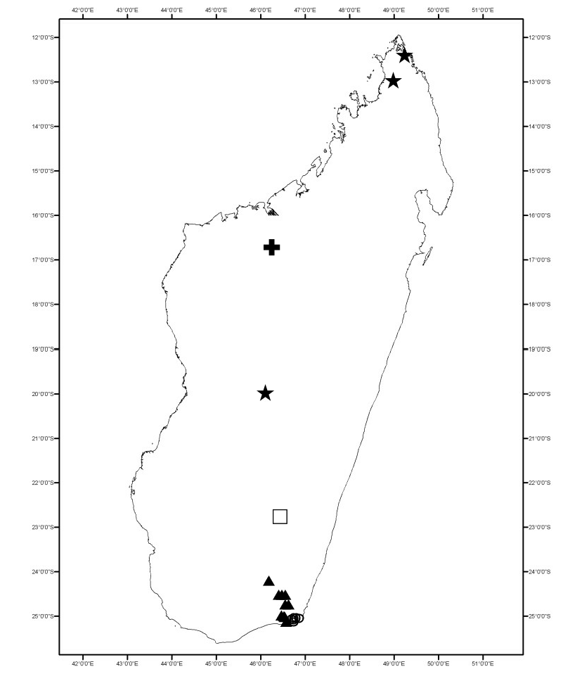
D I S T R I BU T I O N. — Talinella humbertii is known from southeastern Madagascar ( Fig. 6 View FIG ), primarily on granite, in dry or transitional forests, and from low altitudes to over 1000 m (possibly to 1400 m).
CONSERVATION STATUS. — Provisional IUCN Red List Category: possible Near Threatened (NT). The extent of occurrence is estimated at 1 7 2 0 k m 2 a n d t h e a re a o f o c c u p a n c y a t a t 44 km 2, with collections from several distinct areas. However, the southernmost of these are in a region where considerable human-mediated ecological degradation has occurred, creating reason for concern.
PARATYPES. — MADAGASCAR: Prov. Toliara: Croat 31953, along Route #10, 16 km W of Manambaro , 25°02’S, 046°39’E, 110 m, fl., 21 Feb 1975 ( P, MO) GoogleMaps ; Eboroke 808, Andohahela RNI, Fort-Dauphin, Ranopiso, Mahamavo , forêt sèche sur un bord de rivière, 24°45’S, 046°45’E, 100 m, fr., 10-20 May 1994 ( P, MO) GoogleMaps ; Humbert 12448, vallée moyenne du Mandrare près d’Anadabolava, forêt sèche, 200-250 m, 24°12’S, 046°19’E, Dec. 1933 ( P) GoogleMaps ; Humbert 12804, vallée de la Manambolo, rive gauche (bassin du Mandrare) aux environs d’Isomonony (confluent de la Sakamalio), monts Kotriha et Isomonobe , bush xérophile, 400-600 m, 24°32’S, 046°34’E, fl., Dec. 1933 - Jan. 1934 ( P, MO, K) GoogleMaps ; Humbert 13115, vallée de la Manambolo, rive droite (bassin du Mandrare) aux environs d’Isomono [= Esomony] (confluent de la Sakamalio), mont Morahariva , 900-1200 m, 24°32’S, 046°38’E, fl., fr., Dec. 1933 ( P, MO, K, G) GoogleMaps ; Humbert 13269, same locality, rocailles gneissiques, 1000- 1400 m, 24°32’S, 046°38’E, fr., Dec. 1933 ( P, MO) GoogleMaps ; Humbert 13737, bassin de réception de la Mananara, affluent du Mandrare, pentes occidentales des mon- tagnes entre l’Andohahela et l’Elakelaka, entre Ampahiso et Mahamavo (gneiss), 500-700 m, 24°45’S, 046°43’E, fl., Jan.-Feb. 1934 ( P, MO) GoogleMaps ; Humbert 13847, same locality, mont Apiky au-dessus de Mahamavo , transition du bush xérophile à la forêt basse sclérophylle, c. 700 m, 24°45’S, 046°43’E, fl., Jan.-Feb. 1934 ( P, MO, G, K) GoogleMaps ; Humbert & Capuron 29017, Baie des Galions (Ranofotsy) au SW de Fort- Dauphin, bush xérophile, 1-100 m, 25°09 ’S, 046°43’E, fl., 18-21 Feb. 1955 ( P) GoogleMaps ; Humbert & Capuron 29150, mont Vohitsandriana au sud de Ranopiso, sud-ouest de Fort-Dauphin, forêt de transition sur granite, 200-500 m, 25°03’S, 046°41’E, fl., 27 Feb. 1955 ( P) GoogleMaps ; Phillipson & Milijaona 3522, Andohahela RN, 100 m, 25°02’S, 046°40’E, fl., 17 Feb. 1990 ( MO, TAN) GoogleMaps ; Réserves Naturelles (Rakotoson) 10784, District Fort-Dauphin, Canton Ambavatary , fl., 30 Mar. 1960 ( P, TEF) ; Service Forestier 22397, formations de transition entre le bush xérophile et la forêt tropophylle, au P. K. 448 de la route Amboasary-Fort-Dauphin (aux environs Est de Bevilany ), 25°01’S, 046°36’E, fl., 13 Jan 1963 ( P, TEF) GoogleMaps .
The collection Rogers & Rakotonasolo 632, Prov. Fianarantsoa, N of RN 10, 5 km W of Ihosy along road and slopes to summit, 725 m, 22°13’47”S, 046°21’0”E, fr., 24 May 2004 (MO, P, TAN) may also be referable to T. humbertii , which would greatly extend the range of that species. Its seeds lack a ridge; its leaves are consistent with T. humbertii and do not resemble those of other Talinella collections from the region of Ihosy (two unclassified BOSSER specimens, discussed below).
| P |
Museum National d' Histoire Naturelle, Paris (MNHN) - Vascular Plants |
| W |
Naturhistorisches Museum Wien |
| MO |
Missouri Botanical Garden |
| K |
Royal Botanic Gardens |
| G |
Conservatoire et Jardin botaniques de la Ville de Genève |
| TAN |
Parc de Tsimbazaza |
| TEF |
Centre National de la Recherche Appliquée au Developement Rural |
No known copyright restrictions apply. See Agosti, D., Egloff, W., 2009. Taxonomic information exchange and copyright: the Plazi approach. BMC Research Notes 2009, 2:53 for further explanation.