
Serrapinnus tocantinensis Malabarba & Jerep, 2014
|
publication ID |
https://doi.org/ 10.11646/zootaxa.3847.1.3 |
|
publication LSID |
lsid:zoobank.org:pub:93242732-2B5A-4083-8EC5-6FA53BD83E7D |
|
DOI |
https://doi.org/10.5281/zenodo.4928402 |
|
persistent identifier |
https://treatment.plazi.org/id/03BCEF20-EC0E-FF88-FF68-FCEFFC9A45FC |
|
treatment provided by |
Felipe |
|
scientific name |
Serrapinnus tocantinensis Malabarba & Jerep |
| status |
sp. nov. |
Serrapinnus tocantinensis Malabarba & Jerep View in CoL n. sp.
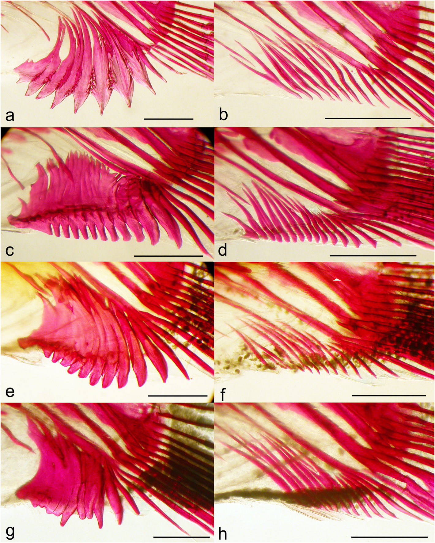
Figs. 2g –h View FIGURE 2 , 4d View FIGURE 4 , 5d View FIGURE 5 , 10 View FIGURE 10 , 11 View FIGURE 11
Holotype. UFRGS 16442 View Materials , 32.5 mm SL, male, Brazil, Mato Grosso, Município de Barra do Garças, córrego Fundo , tributary of rio das Garças, 16°52’40.5’’S 52°18’15.1’’W, 8 Feb 2010, V. A. Bertaco, F. R. Carvalho & F. C. Jerep. GoogleMaps
Paratypes. All from Brazil, rio Tocantins-Araguaia basin. Goiás State: MCP 19987, 3 View Materials , 33.5 View Materials –37.0 mm SL, rio Tocantins, 3 km down on Serra da Mesa Dam GoogleMaps , Município de Minaçú GoogleMaps , 13°50’51’’S 48°16’60’’W, 6 Nov 1996, C. A. S. Lucena & J. F. P. Silva. MCP 19988, 8 View Materials , 28.5–37.3 mm SL (6, 34.8–37.5 mm SL), rio Tocantins, at porto do Rubão GoogleMaps , Município de Minaçú GoogleMaps , 13°44’31’’S 48°8’29’’W, 7 Nov 1996, C. A. S. Lucena & J. F. P. Silva. MCP 42175, 1 View Materials , 25.0 mm SL, headwaters of córrego Salobrona GoogleMaps , tributary of rio Claro GoogleMaps , Município de Montes Claros GoogleMaps de Goiás, 16°02’38’’S 51°22’11’’W, 5 Jun 2007, G. A. Pereira. MCP 42269, 2 View Materials , 24.8–31.6 mm SL, córrego Salobrona GoogleMaps , tributary of rio Claro GoogleMaps , Município de Montes Claros GoogleMaps de Goiás, 15°56’19’’S 51°20’58’’W, 5 Jun 2007, G. A. Pereira. MCP 42360, 6 View Materials , 16.0– 29.4 mm SL, córrego Varginha GoogleMaps , tributary of rio Claro GoogleMaps , Município de Montes Claros GoogleMaps de Goiás, 15°57’52’’S 51°18’40’’W, 5 Jun 2007, G. A. Pereira. MZUSP 4826 View Materials , 33 View Materials , 14.1–32.6 mm SL, rio Araguaia GoogleMaps , Município de Aruan GoogleMaps , 15–19 Sep 1966, Exc. DZ. MZUSP 40362 View Materials , 27 View Materials , 23.6–29.8 mm SL, 4c&s, 26.0– 30.1 mm SL (6, 26.6–29.9 mm SL), marginal lagoon of riacho Seco GoogleMaps , close to bridge on highway GO 447, Município de Galheiros GoogleMaps , 14 Jan 1989, J. C. Oliveira & W. Costa. MZUSP 40378 View Materials , 36 View Materials , 13.2–21.8 mm SL, rio Macacos GoogleMaps (also Macaquinhos), tributary at right margin of rio Paraná, Fazenda Fortaleza GoogleMaps , Município de Flores GoogleMaps de Goiás, 10 Sep 1988, J. C. Oliveira & W. Costa. MZUSP 40497 View Materials , 12 View Materials , 14.3–21.9 mm SL, rio Paraná, waterfall at Fazenda Olho GoogleMaps d`Água, Município de Flores GoogleMaps de Goiás, 12 Sep 1988, J. C. de Oliveira & W. J. M. Costa. MZUSP 40547 View Materials , 5 View Materials , 17.9–22.2 mm SL, rio Prata GoogleMaps , bridge on highway GO 112, Município de Iaciara GoogleMaps , 14 Sep 1988, J. C. Oliveira & W. J. M. Costa. MZUSP 40704 View Materials , 4 View Materials , 31.1–34.2 mm SL, rio Bezerra GoogleMaps , tributary at right margin of rio Paraná, Município de Flores GoogleMaps de Goiás, 22 Sep 1988, J. C. Oliveira & W. Costa. MZUSP 40858 View Materials , 6 View Materials , 20.9 View Materials –26.0 mm SL, rio Paraná, between rio Macaco and rio Bezerra, Município de Monte Alegre de Goiás, Sep 1988, J. C. Oliveira & W. Costa. UFRGS 12021 View Materials , 7 View Materials , 27.9–31.3 mm SL, same data as holotype. UFRGS 12028 View Materials , 20 View Materials , 14.1–26.3 mm SL, rio das Almas, between Aragarças and Jussara, Município de Aragarças, 15°52’2.4’’S 51°38’57.7’’W, 6 Feb 2010, V. A. Bertaco, F. R. Carvalho & F. C. Jerep. UFRGS 12035 View Materials , 5 View Materials , 26.8–32.8 mm SL, stream tributary of rio Claro GoogleMaps , between Aragarças and Jussara, Município de Aragarças, 15°52’10.8’’S 51°32’56.6’’W, 6 Feb 2010, V. A. Bertaco, F. R. Carvalho & F. C. Jerep. Tocantins State: MZUSP 115013 View Materials , 2 View Materials , 26.5–27.3 mm SL, temporary pond on rio Paraná and rio Bezerra GoogleMaps confluence, Município de Arraias GoogleMaps , 11 Jan 1989, J. C. Oliveira & W. Costa. UFRJ 1708, 24, 20.8–29.8 mm SL, tributary of rio Verde GoogleMaps , 50 km from São Miguel do Araguaia GoogleMaps , 28 Aug 1993, W. Costa, E. Vicente, M. Britto, F. Autran & R. D`Arrigo. UNT 4143 View Materials , 2 View Materials , 25.1–25.2 mm SL, Lagoa Dionísio, Fazenda Água Branca, Município de Peixe GoogleMaps , 11 March 2000, NEAMB-UFT. UNT 4265 View Materials , 18 View Materials , 20.0– 26.8 mm SL, Lagoa Maranhão, Fazenda Traçada, Município de Paraná, 18 Nov 1998, NEAMB. UNT 4757 View Materials , 30 View Materials , 16.7–27.2 mm SL, Lagoa Água Branca at Fazenda Água Branca, Município de Peixe GoogleMaps , 21 Aug 2001, NEAMB-UFT. UNT 7321 View Materials , 20 View Materials , 18.2–26.1 mm SL, rio Tocantins, Fazenda Traçada, Município de Paraná, 10 May 2000, NEAMB-UFT. Mato Grosso State: MCP 34172, (4, 29.2–31.7 mm SL), córrego Barreiro, tributary of rio São João GoogleMaps on road to Vila Berrante, ribeirão Cascalheira 12°57’39’’S 51°40’56’’W, 28 Jul 2003, T. Carvalho & G. Carvalho. MCP 40417, 58 View Materials , 19.2–36.2 mm SL (8, 32.5–36.1 mm SL, 3c&s, 30.6–33.4 mm SL), stream on highway BR158 , 61 km south of Porto Alegre do Norte GoogleMaps , 11°22’28’’S 51°39’42’’W, 28 October 2005, J. F. P. Silva. MCP 40473, (4, 25.9–30.3 mm SL), córrego Pium, 22 km south of Posto da Mata GoogleMaps , on highway BR158 between Posto da Mata and Al Brasil, 11°53’58’’S 51°39’26’’W, 29 Oct 2005, J. F. P. Silva. MCP 40263, 89 View Materials , 16.1–25.4 mm SL, rio Crisostomo GoogleMaps on highway BR158 between Vila Rica and Confresa, Município de Vila Rica, 10°14’33’’S 51°10’08’’W, 26 Oct 2005, J. F. P. Silva. MCP 44522, 62 View Materials , 9.4–20.4 mm SL, ribeirão São Marcos on highway BR158 between Confresa and Vila Rica, Município de Vila Rica, 10°06’05’’S 51°06’00’’W, 23 Apr 2006, J. F. P. Silva & L. Cotrim. MCP 44526, 32 View Materials , 9.8 View Materials –19.0 mm SL, ribeirão Santana 30 km north of Vila Rica GoogleMaps on highway BR158 , Município de Vila Rica GoogleMaps , 09°49’11’’S 51°03’21’’W, 23 Apr 2006, J. F. P. Silva & L. Cotrim. MCP 44527, 21 View Materials , 15.8–23.1 mm SL, rio Crisostomo GoogleMaps on highway BR158 between Vila Rica and Confresa, 10°14’33’’S 51°10’08’’W, 22 Apr 2006, J. F. P. Silva & L. Cotrim. MCP 44530, 8 View Materials , 10.6–19.1 mm SL, rio Tapirapé GoogleMaps , Município de Porto Alegre do Norte GoogleMaps , 10°51’00’’S 51°37’00’’W, 22 Apr 2006, J. F. P. Silva & L. Cotrim. MCP 44532, 3 View Materials , 11.1–28.8 mm SL, rio Preto GoogleMaps on highway BR158 , 72 km south of Porto Alegre do Norte GoogleMaps , 11°27’47’’S 51°40’42’’W, 21 Apr 2006, J. F. P. Silva & L. Cotrim. MCP 44534, 20 View Materials , 18.6–30.1 mm SL, rio Paciguara GoogleMaps 2 km north of Confresa GoogleMaps on highway BR158 , Município de Confresa GoogleMaps , 10°37’34’’S 51°32’51’’W, 22 Apr 2006, J. F. P. Silva & L. Cotrim. MCP 44535, 10 View Materials , 9.5–22.6 mm SL, rio Xavantinho GoogleMaps 16 km South of Porto Alegre do Norte, 11°01’30’’S 51°38’47’’W, 21 Apr 2006, J. F. P. Silva & L. Cotrim. Par State: INPA 20976 View Materials , 32 View Materials , 27.9–36.4 mm SL (8, 30.6–35.1 mm SL), Igarapé Canoal, Município de Breu Branco GoogleMaps , 12 Nov 1981, equipe de Ictiologia INPA. INPA 20977 View Materials , (6, 28.3–34.4 mm SL), Igarapé tributary of rio Sossego GoogleMaps , Município de Parauapebas GoogleMaps , Cana Carajás, 14 Mar 2002, G. Mendes. INPA 20978 View Materials , 13 View Materials , 18.4–32.7 mm SL (4, 29.1–31.7 mm SL), Igarapé tributary of rio Sossego GoogleMaps , Município de Parauapebas GoogleMaps , Cana dos Carajás, 14 Mar 2002, G. M. Santos. INPA 20979 View Materials , 7 View Materials , 24.5–35.3 mm SL, Igarapé Bacuri, 6 Jul 1982, equipe de Ictiologia INPA. INPA 20984 View Materials , 20 View Materials , 31.5–36.8 mm SL (5, 32.2–36.5 mm SL), Igarapé Bacuri, 26 Nov 1981, Eq. Ictiologia INPA. INPA 20986 View Materials , 27 View Materials , 32.4–39.8 mm SL (7, 35.0– 39.7mm SL, 3c&s, 34.3–35.0 mm SL), Igarapé Bacuri, close to DNER, 26 Nov 1981, equipe de Ictiologia INPA. MCP 24199, 8 View Materials , 28.9–32.8 mm SL, Igarapé Cinzento, tributary on left margin of rio Itacaiúnas GoogleMaps , 05°51’1’’S 50°32’7’’W, Jul 1997, P. S. Pompeu. MZUSP 4936 View Materials , 188 View Materials , 11.4–34.6 mm SL, tributary of rio Araguaia GoogleMaps , highway Belém-Brasilia, 30 km North of Gurupi, 31 May 1966, Expedition DZUSP. MZUSP 18144 View Materials , 30 View Materials , 21.8–29.4 mm SL, lagoon in front of Jatobal, 17 Sep 1970, EPA. Distrito Federal: USNM 292213 View Materials , 1 View Materials , 33.8 mm SL, rio Maranhão, about 35 km north of Brasília GoogleMaps , 15°30’S 47°50’W, 14 Nov 1984, W. C. Starnes, M. Ribeiro, R. Mendonça, et al.
Diagnosis. Serrapinnus tocantinensis can be diagnosed from its congeners by the elongation of the unbranched dorsal and pelvic-fin rays into filaments in mature males. Furthermore S. tocantinensis can be distinguished from S. sterbai by the absence of a continuous mid-lateral black stripe extending from the opercular region to the caudalpeduncle spot, and from the remaining species of the genus by the presence of 9 to 11 cusps in the premaxillary teeth (vs. 5 in S. microdon and S. potiguar , 7 in S. aster , 7 to 9 in S. calliurus , S. heterodon , S. kriegi , S. micropterus , S. notomelas and S. piaba and 10 to 12 in S. gracilis and S. littoris ), dentary teeth without expanded cusps forming a sharp cutting edge (vs. dentary teeth with expanded cusps forming a sharp cutting edge in S. heterodon ), hyaline dorsal fin (vs. with a proximal black blotch in S. notomelas ), and the absence of a black spot on the posteroventral region of the abdomen (vs. the presence of a black spot in that region in S. kriegi ).
Description. Morphometric data presented in Table 4. Body elongated and compressed. Greatest body depth at dorsal-fin origin. Snout anteriorly rounded in lateral profile. Dorsal profile of head gently convex from vertical through posterior margin of posterior nares to base of supraoccipital spine, then straight to slightly concave to tip of supraoccipital spine. Predorsal profile slightly convex between tip of supraoccipital spine and dorsal-fin origin. Straight to slightly convex along dorsal-fin base. Dorsal profile from insertion of last dorsal-fin ray to adipose fin slightly convex in immatures and females; deeply convex in mature males with ventrally arched caudal peduncle. Dorsal profile straight to slightly concave from adipose-fin base to most anterior dorsal procurrent caudal-fin ray. Distal tip of lower jaw convex. Ventral profile of head straight to gently convex along ventral profile lower jaw to vertical through posterior margin of eye; convex from that point to pelvic-fin origin. Ventral region from pelvic-fin insertion to anal-fin origin slightly concave to straight in immature and females; deeply concave in mature males. Anal-fin base slightly concave in immature and females; distinctly convex anteriorly and straight posteriorly in mature males. Ventral profile of caudal-peduncle slightly concave in females; distinctly convex in mature males due to hypertrophied procurrent caudal-fin rays extending ventrally through muscles and skin ( Figs. 2g –h View FIGURE 2 , 10 View FIGURE 10 ). Caudal peduncle slightly longer than deep; ventrally arched in alcohol preserved mature males. Head anteriorly tapered in lateral view. Posterior margin of opercle sinusoidal with upper portion concave and lower portion convex. Mouth terminal, mouth slit just below horizontal through middle of pupil. Maxilla angled posteroventrally; posterior tip reaching vertical through anterior border of orbit and horizontal through ventral border of orbit. All teeth multicuspidate, pedunculate, compressed and expanded distally ( Fig. 11 View FIGURE 11 ). Premaxillary teeth 5(5) with 9 to 11 cusps; central cusp slightly longer and wider than lateral cusps. Two (4) maxillary teeth with 7 to 9 cusps. Dentary teeth 6(1), 7(2) or 8(3) with 7 to 9 cusps, rarely followed by one smaller tricuspid teeth. Lateral small cusps of dentary teeth overlapping adjacent tooth cusps; overlap usually not present on posterior teeth. All dentary tooth cusps dorsally pointed or slightly recurved towards interior of mouth.
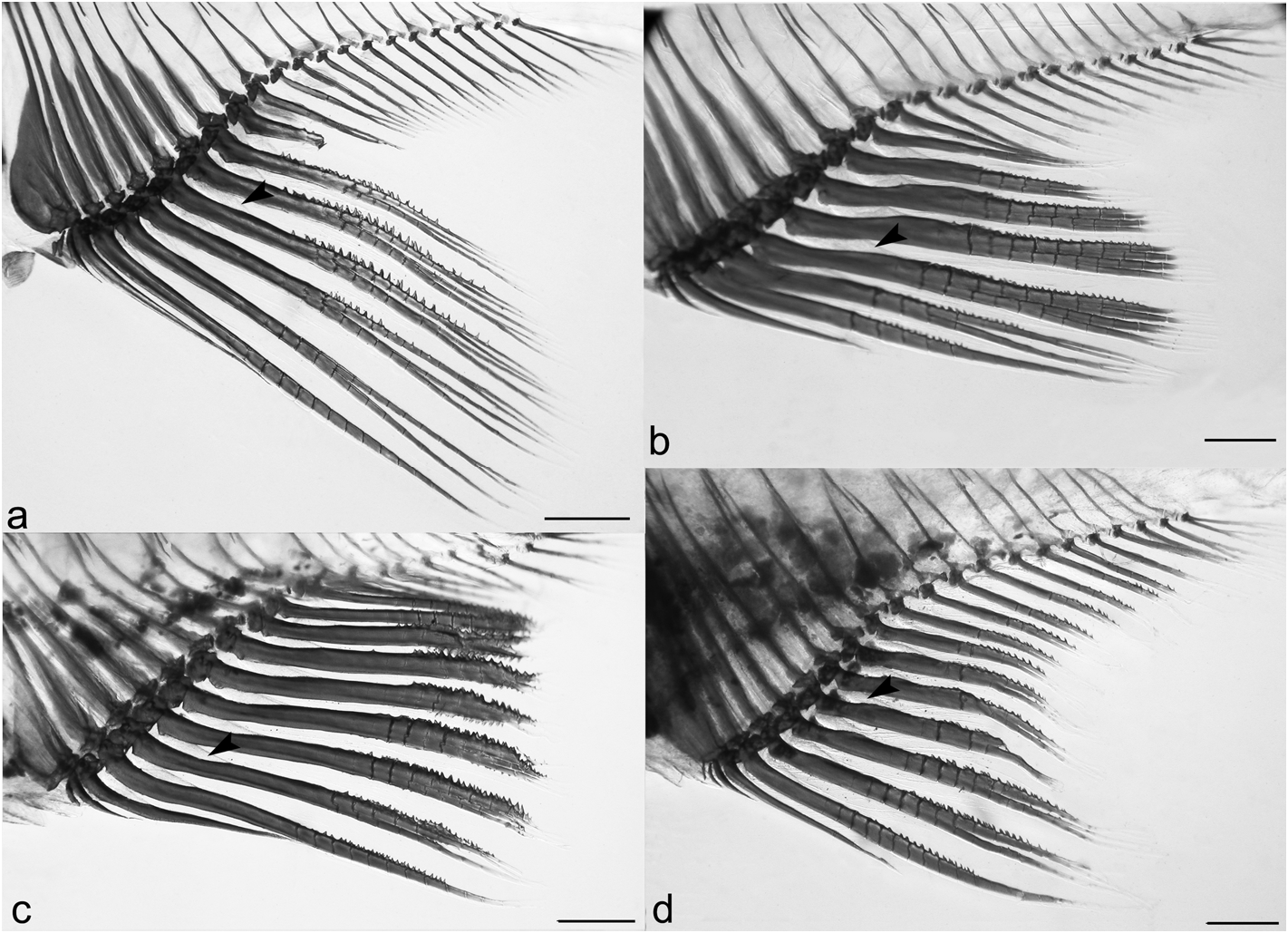
Dorsal-fin rays ii,8(2), 9*(65). Dorsal-fin origin slightly anterior to vertical through midlength of standard length. First unbranched dorsal-fin ray about one-half length of second unbranched dorsal-fin ray. Second unbranched dorsal-fin ray longest in fin with branched rays slightly decreasing in size posteriorly. Second unbranched dorsal-fin ray elongated into small filament in mature males. Adipose-fin origin slightly anterior to vertical through base of last anal-fin ray in females and slightly posterior to that point in males. Anal-fin origin posterior to vertical through base of last dorsal-fin ray. Anal-fin rays iii–iv,15*(1), 17(2), 18(19), 19(33), 20(10) or 21(1). Distal border of anal-fin concave; last unbranched and anterior 5–6 first branched rays longest; ray length abruptly decreasing after sixth ray with remaining rays decreasing in size to end of anal fin. Distal tip of longest anal-fin ray of mature males reaching to vertical through base of last anal-fin ray; sometimes reaching ventral procurrent caudal-fin rays when caudal peduncle deeply arched. Males with acute, elongate, retrorse hooks on distal half of anal-fin rays; hooks posterolaterally arranged on last unbranched to 11 th or 17 th branched rays. Two or 3 unpaired hooks per ray segment of each contralateral lepidotrichia ( Fig. 4d View FIGURE 4 ). Hooks generally situated on posterior margin of posterior ray branches. Hook bearing ray segments and branches progressively fused during maturation of males. Mature males with hypertrophied soft whitish tissue on interradial membrane anterior to analfin hooks. Pectoral-fin rays i,9*(18), 10(36) or 11(13). Pectoral-fin ray reaching pelvic-fin origin in immatures and females, but extending beyond that point in adult males. Pelvic-fin rays i,6(2) or 7*(65). Pelvic-fin origin slightly anterior to vertical through dorsal-fin origin. Pelvic fin falling short of anal-fin origin in immature and females; extending far beyond that point in adult males. Males with one or two acute, elongate, ventral-medially situated hook per lepidotrichia segment on all pelvic-fin rays. Adult males with hypertrophied soft whitish tissue anterior to hooks on ventral surface of pelvic fin. Principal caudal-fin rays 17(2) or 19*(65). Procurrent caudal-fin rays: dorsal 12(2), 13(1) or 15(3); ventral 12(1), 13(2) or 14(3). Adult males with ventral procurrent caudal-fin rays hypertrophied, commonly fused, with distal tips extending beyond muscles and skin of caudal-peduncle. Hypertrophied ventral procurrent caudal-fin rays elongated, rod-shaped, anteriorly bent, proximally acute and slightly expanded distally ( Fig. 2g View FIGURE 2 ).
Scales cycloid; similar in size over all body. Lateral line partially pored with 8(1), 11(5), 12(2), 14(7), 15(4), 16(2), 17(6), 18(2), 19(2), 20(2), 21(1), 23(1), 32(5), 33(7), 34(11), 35*(7) or 36(2) pored scales. Scales in lateralline series 31(3), 32(9), 33(22), 34(16), 35*(15) or 36(2). Predorsal series in regular row 8(1), 9*(9), 10(34) or 11(23). Scale rows between lateral line and dorsal-fin origin 5(49) or *6(18). Scale rows between lateral line and pelvic-fin origin 4*(64) or 5(3). Scale rows around caudal peduncle 12(3), 13(24), 14*(36) or 15(4). Axillary scale on pelvic fin base extending posteriorly one or two scales. Scales along anal-fin base 9(4), 10(12), 11(24), 12(14), 13(6), 14(2), 15*(3) or 17(1).
Counts based on six clear and stained specimens: supraneurals 4(4) or 5(2); abdominal vertebrae 15(5) or 16(1); caudal vertebrae 19(4) or 20(2).
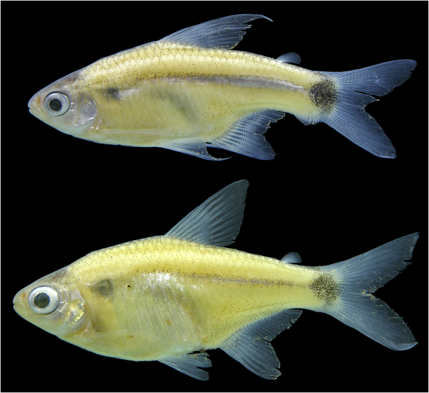
Color in alcohol. Overall ground coloration of body pale yellow, darker dorsally from head to caudal peduncle. Body with faint dark, sometimes silver, midlateral stripe usually forming black line along middle longitudinal body axis. Longitudinal stripe extending from region slightly anterior to vertical through dorsal-fin origin to caudal spot. Scale series above longitudinal line with darker chromatophores mostly on posterior border of scales, resulting in faint reticulated pattern. Abdominal region ventral to longitudinal line more lightly colored and without pigmentation. Caudal spot rounded, black, situated over posterior of caudal peduncle and base of middle caudal-fin rays, but falling short of upper or lower margin of peduncle. Fins mostly hyaline with scattered, sparse, dark chromatophores. Adipose fin unpigmented. Caudal fin with dark chromatophores along fin rays, except for clear areas on base of each caudal-fin lobe. Humeral region with triangular, dark area due to pseudotympanum in musculature ( Fig. 10 View FIGURE 10 ).
Sexual dimorphism. Mature males of S. tocantinensis have hooks on the pelvic and anal-fin rays. The caudal peduncle is ventrally arched, as commonly observed in species of Serrapinnus . The hook bearing anal-fin rays are hypertrophied, expanded in the sagittal plane, and sometimes have fused ray segments. Adult males also have the last unbranched dorsal-fin ray and the first pelvic-fin ray elongated, sometimes in a short filament. The ventral procurrent caudal-fin rays are hypertrophied in mature males, and extend ventrally through the caudal peduncle muscles and skin ( Figs. 2g –h View FIGURE 2 , 4d View FIGURE 4 , 10 View FIGURE 10 ).
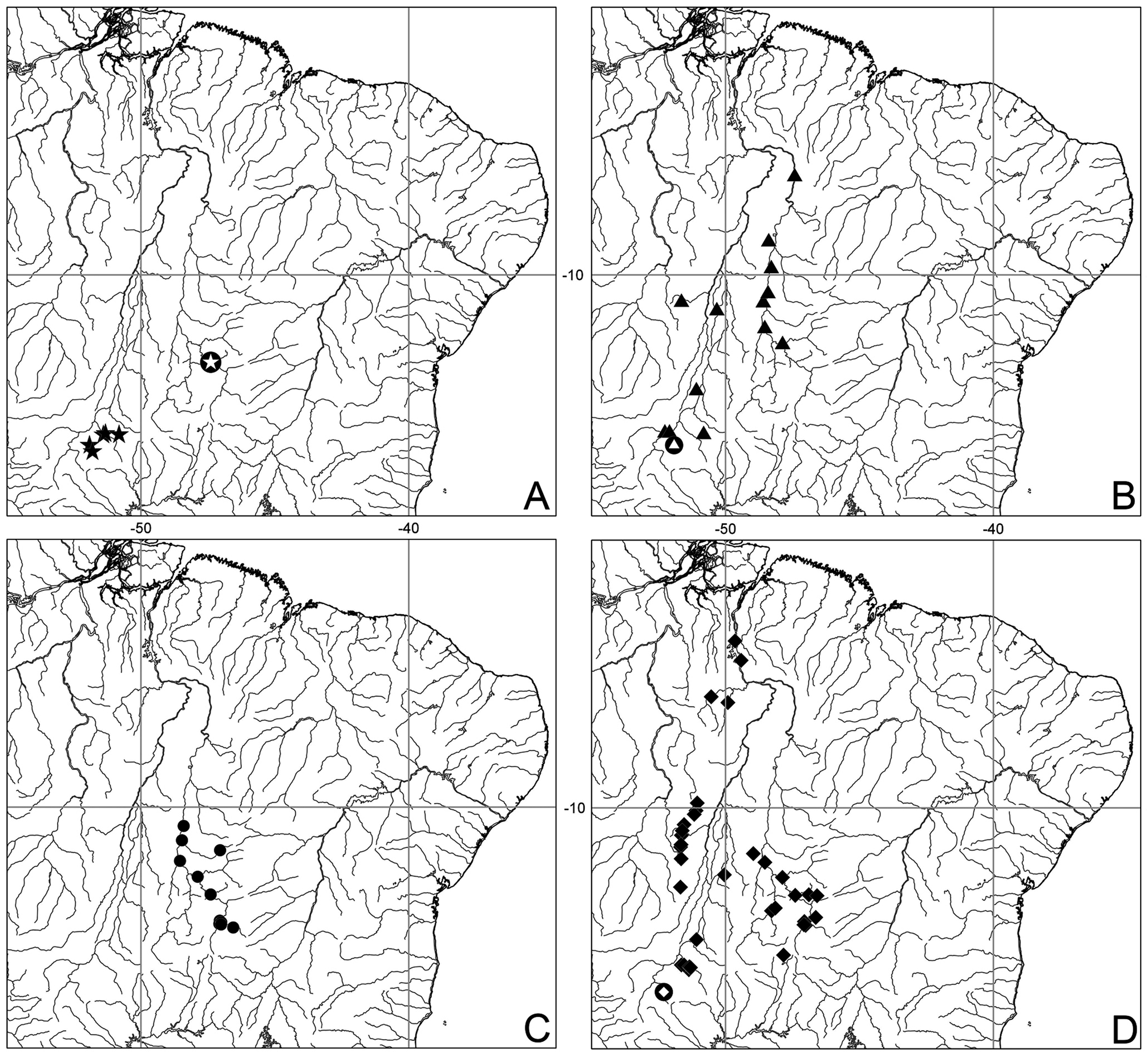
Distribution. Serrapinnus tocantinensis is distributed throughout the rio Tocantins-Araguaia basin, from the upper to the lower portions of the system ( Fig. 5d View FIGURE 5 ).
Etymology. The species name, tocantinensis , refers to the restricted geographic distribution of the species to the rio Tocantins-Araguaia basin. A noun in apposition.

No known copyright restrictions apply. See Agosti, D., Egloff, W., 2009. Taxonomic information exchange and copyright: the Plazi approach. BMC Research Notes 2009, 2:53 for further explanation.
|
Kingdom |
|
|
Phylum |
|
|
Class |
|
|
Order |
|
|
Family |
|
|
Genus |