
Pandanus decumbens (Brongn.) Solms
|
publication ID |
https://doi.org/ 10.15553/c2013v681a4 |
|
DOI |
https://doi.org/10.5281/zenodo.5735572 |
|
persistent identifier |
https://treatment.plazi.org/id/03E887D7-FFB4-CF18-FCCE-FE98FE169EFE |
|
treatment provided by |
Carolina |
|
scientific name |
Pandanus decumbens (Brongn.) Solms |
| status |
|
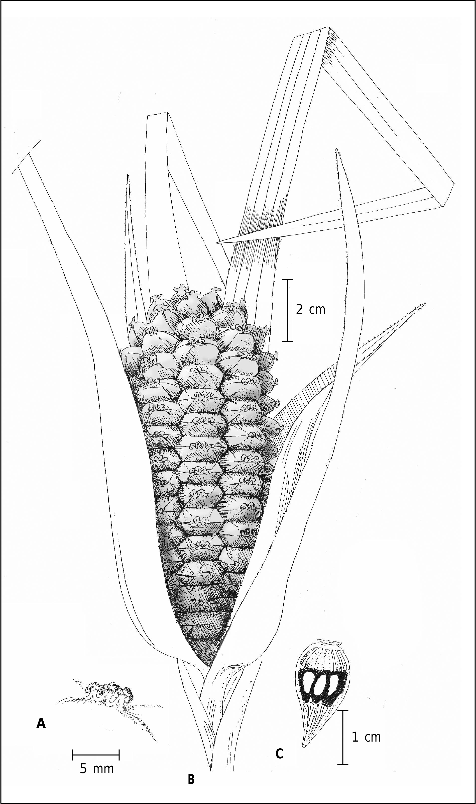
Pandanus decumbens (Brongn.) Solms View in CoL in Linnaea 42: 47. 1878 ( Fig. 1 View Fig , 2 View Fig , 3A View Fig ).
Ξ Barrotia decumbens Brongn. in Ann. Sci. Nat., Bot. ser. 6, 7: 285. 1875.
Lectotypus: NEW CALEDONIA: Iles des Pins, sur les pentes du Pic [N’ga], [23°20’42’’S 167°27’25’’E], fr., Pancher 342 ( P [P02077365]!; GoogleMaps iso-: FI!, P [P02077364, P02077366, P02077367, P02139406]!) (lectotypified by ST. JOHN, 1989: 24) GoogleMaps .
= Pandanus neocaledonicus Martelli View in CoL in Webbia 4: 416. 1914.
Lectotypus (designated here): N EW CALEDONIA: s.d., fr., s.coll. ( FI!; iso-: P [ P 00700817 ]!).
= Pandanus schlechteri Warb. View in CoL in Bot. Jahrb. Syst. 39: 17. 1906.
Typus: NEW CALEDONIA: Süd-Bezirk. Auf den Bergen bei Yaouhé , [22°11’45’’S 166°29’54’’E], 400 m, X.1902, fr., Schlechter 15053 (holo-: B [ B100 352291 , image seen]!; GoogleMaps iso-: FI!, P [P00649506]!). GoogleMaps
– Pandanus reticulatus sensu Martelli View in CoL in Webbia 4: 29, 62, 94. 1913; 4: tab. 2, fig. 7-9. 1914.
Slender-stemmed shrub, the stem usually decumbent, branched or not, often quite short but sometimes elongated, up to 4 m tall, with rather smooth light brown bark and a few distant blunt prickles; few prop roots, little developed, to ca. 20 cm long. Leaves linear-attenuate, mostly 100-135(-160) cm long, (15-)20-25(-50) mm wide, apex attenuate, sometimes sub-flagellate; thin sub-coriaceous to chartaceous, dark green and shiny axially, paler green and shiny adaxially; longitudinal veins visible on both surfaces; marginal prickles borne 7-8 cm above base to apex, antrorse, 0.5-1 mm long in the lower third, 2-8 mm apart, 0.4-0.6 mm long in the mid-third, 2-4 mm apart, to 0.2-0.4 mm long in the distal third, 1-2 mm apart, subappressed; midrib unarmed in the lower half, prickles> 0.2 mm long towards the apex, irregularly spaced but mostly 2-10 mm apart; apical ventral pleats with antrorse prickles,> 0.2 mm mm long, mostly 1-6 mm apart; sheath 5-7 cm long, ca. 2-3 cm wide at apex, 4-5 cm at base. Infructescence terminal, the solitary syncarp sub-cylindric, (3-) 7-15 cm long, (3-) 5-8 cm wide, peduncle ca. 8-15(-35) cm long, ca. 2 cm thick at apex, bearing foliaceous bracts, the proximal ones ca. 60-80 cm long, the distal one 12-14 cm long, crowded at peduncle apex and often covering the syncarp. Drupes numerous, 100-180, ca. 15-25 mm long, 10-20 mm wide, 4-10 mm thick, mostly (1-)3-4(-5)-celled, (4-)6-angled, obovoid, at apex truncate or shallowly concave, upper third free with smooth, dull, gently incurved faces. Stigma (1-)3-4(-5), ca. 1-2 mm wide, slightly heightened (ca. 2 mm) on an appressed style, forming one row, deflected toward the cephalium apex. Endocarp median, ca. 10 mm long, concave at apex, lateral walls 2-4 mm thick; proximal mesocarp 8-10 mm long, fibrous-fleshy, distal mesocarp 6-10 mm long, sparsely fibrous, chambered, seed locule ca. 4 × 7 mm, ellipsoid. Staminate inflorescence a raceme of spikes, ca. 13-23 cm long; peduncle fleshy; bracts ca. 10, distal ones foliaceous, proximal ones caniculate, the distal bract ca. 2 × 10 cm; spikes (4-)5, mostly 2-4 cm long, up to 15 mm diam., short cylindric, composed of crowded phalanges of stamens (stemanophore); its a column 4-6 mm long, apically distended, umbrella like, peltate, to ca. 4-5 mm wide, blackish when dry; stamens ca. 50-70, borne along upper part of the stemanophore and (mostly) under the apical discoid surface; filaments ca. 0.5 mm long; anthers 1.5- 2.4 mm long, to 0.5 mm wide, pale yellow, apiculate; apiculus 0.2 mm long.
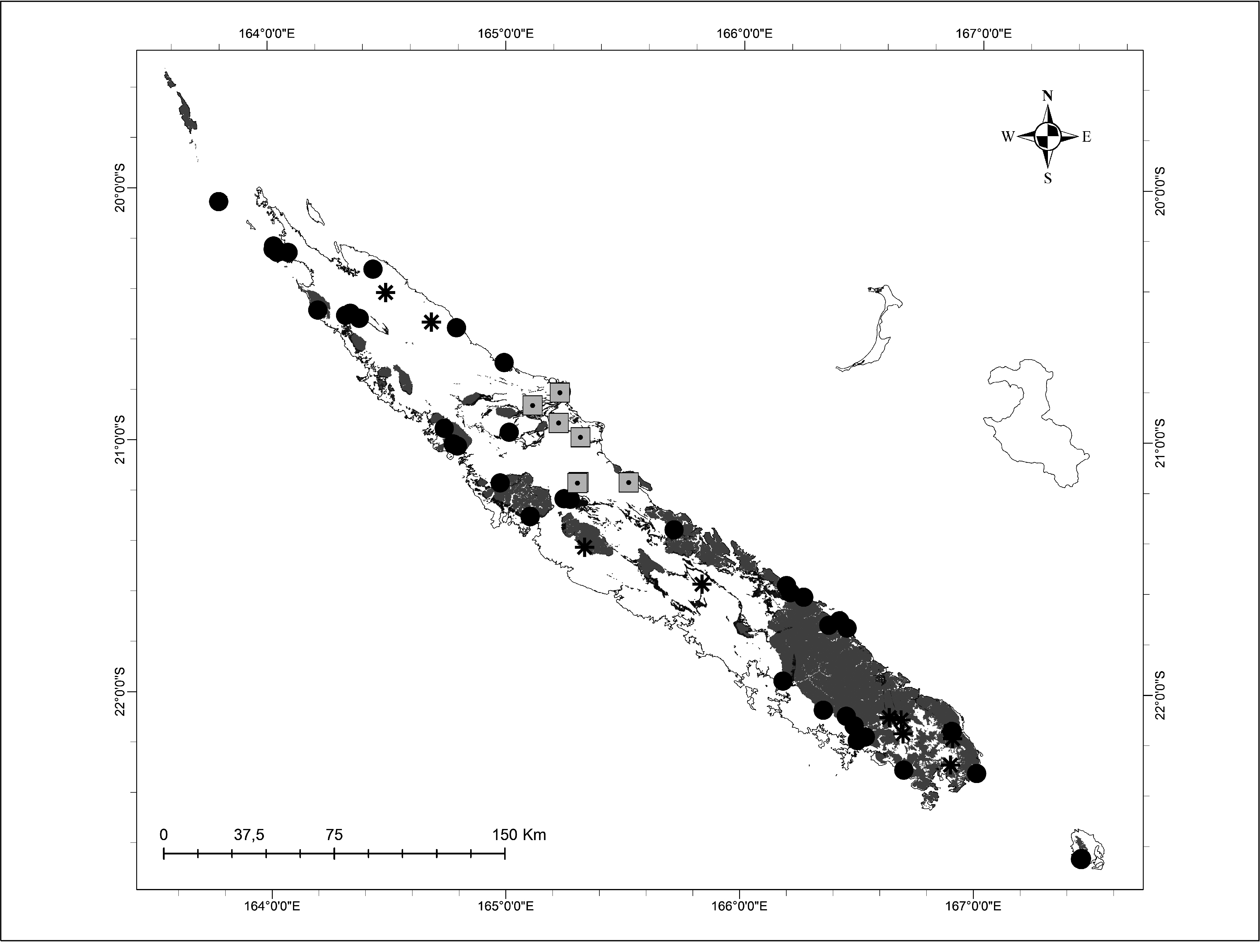
Distribution and ecology. – Pandanus decumbens is mostly found at lower to mid elevations (0-400 m). It grows on both serpentine and calcareous substrates, usually in rocky sites. The species is widespread along the west coast from Iles des Pins to Koumac usually in Maquis or dry forests and often along creeks ( Fig. 1 View Fig ).
Conservation status. – With an EOO of 15 642 km 2, an AOO of 324 km 2, and 18 subpopulations, three of which are situated within the protected area network (Barrage Yaté, Mt. Panié, Vallée de la Thy), P. decumbens is assigned a preliminary status of Least Concern (LC) based on the IUCN Red List Categories and Criteria ( IUCN, 2001).
Notes. – Pandanus decumbens was described by BRONGNIART (1875) under the basionym Barrotia decumbens Brongn. , it was based on two syntypes: Balansa s.n. and Pancher 342. Balansa s.n. has not been located either at FI or at P. Pancher 342 is a complete collection comprising leaves, young and mature syncarps and drupes at P and separate drupes at FI. ST. JOHN (1989: 24) therefore designated this collection as the lectotype. The sheet of Pancher 342 at P [P020 77365] bears a label with “n°8” annotation (see “sonneratphoto.mnhn.fr/ 2010/12/03 /2/P02077365.jpg” for scanned specimen), as well as an original Pancher label with “342” clearly indicated. St. John wrongly cited the collection as Pancher 8 when he lectotypified the species. Note that St John actually cited the sheet as the holotype, but this is to be considered as an effective lectotypification since it was published before 2001 (see MCNEILL & al., 2012 [art. 9.23]).
MARTELLI (1914) misinterpreted Pandanus decumbens and considered this species to be a synonym of P. reticulatus along with P. schlechteri Warb. He consequently described a new species, P.neocaledonicus Martelli , to accommodate a specimen (s.coll.) deposited at the Caen Museum. This material is believed to have been destroyed during World War II, but fragments of the collection have been found at FI and P. The FI sheet is designated as lectotype because it is in better condition and less fragmentary than the sheet at P. This collection clearly belongs to P. decumbens with its stigma slightly raised (ca. 2 mm) on an appressed style, arranged in one row and deflected toward the cephalium apex ( Fig. 2 View Fig , 3A View Fig ). Pandanus neocaledonicus is therefore considered as a synonym of P. decumbens along with P. schlechteri , the latter already being treated in this way by ST. JOHN (1989).
Additional material examined. – NEW CALEDONIA: Pic N’ga , [23°20’42’’S 167°27’25’’E], 29.V.1951, fr., Bauman-Bodenheim 13696 ( K, P [ P02077342 ], Z); GoogleMaps Pic N’ga , creek sur les pentes SW, [23°20’42’’S 167°27’25’’E], 30.V.1951, st., Bauman-Bodenheim 13801 ( P [ P 02139407 ]); GoogleMaps Ouroué , [21°34’59’’S 166°11’32’’E], 26.VI.1951, st., Bauman-Bodenheim 13696 ( P [ P 02077340 ]); GoogleMaps Poum , 20°14’08’’S 164°01’23’’E, 13.IV.2006, fr., Barrabé 356 ( NOU [ NOU 014166 ], P [ P 02075145 ]); GoogleMaps N. of Dumbéa valley , [22°08’15’’S 166°29’05’’E], 150 m, 7.VII.1947, fr., Buchholz 1178 ( P [ P 021 39409 ]); GoogleMaps Mont Dzumac , 22°05’59”S 166°27’02”E, 572 m, 23.I.2010, fr., Callmander & al. 827 ( G, NOU, P [ P 00700824 ]); GoogleMaps Sur la route de Gouapin , Nétéa , 21°14’32”S 165°14’50”E, 15 m, 16.II.2011, st. fl., Callmander & al. 976 ( G, MO, NOU); GoogleMaps Sur la route de Gouapin , Nétéa , 21°14’41”S 165°16’25”E, fr., Callmander & al. 977 ( P [ P 007 00859 ]); GoogleMaps Massif du Boulinda , en dessous de la mine Saint-Louis, 21°18’48”S 165°06’12”E, 320 m, 18.II.2011, fr., Callmander & al. 978 ( BISH, G, MO, K); GoogleMaps Massif du Boulinda , en dessous de la mine Saint-Louis, 21°18’44”S 165°06’11”E, 365 m, fr., Callmander & al. 979 ( MO); GoogleMaps Massif de Poum , plaine côté E, 20°15’37’’S 164°02’17’’E, 8.V.2008, y. fr., Dagostini 1603 ( NOU [ NOU 049031 ]); GoogleMaps Iles des Pins , sur les pentes du Pic, [22°39’22’’S 167°27’39’’E], 1862, fr., Deplanche 143 ( P [ P 02077336 ]); GoogleMaps Iles des Pins , 1874-1876, st., Germain s.n. ( P [ P 02077337 , P 02077338 , P 02077339 ]); Mt. Mou , [22°04’35’’S 166°21’08’’E], 15.X.1950, st., Guillaumin & Bauman- Bodenheim 6898 ( P [ P 02077335 ]); GoogleMaps Mt. Mou , 300 m, [22°04’35’’S 166°21’08’’E], 15.X.1950, fr., Guillaumin & Bauman-Bodenheim 6953 ( G, P [ P 02139401 ], Z); GoogleMaps Pic Tiaoué , 200-400 m, 21°10’46’’S 165°01’24’’E, 7.XI.2006, Hequet (Leg. Butin) 3661 ( NOU [ NOU 01 7072 ]); GoogleMaps Ouégoa , St André Yallin , ca. 100 m, [20°19’47’’S 164°26’ 29’’E], 24.VII.1968, fr., Jaffré 60 ( BISH); GoogleMaps Dumbéa N. au bas du Col. , rive droite, [22°08’15’’S 166°29’05’’E], 6.II.1970, st. fl., Jaffré 357 ( BISH, NOU [ NOU 048525 , NOU 048526 ]); GoogleMaps Dumbéa N. au bas du Col. , rive droite, fr., Jaffré 358 ( BISH, NOU [ NOU048528 ]); GoogleMaps vallée de la Thy , [22°10’53’’S 166°31’58’’E], 3.VI.1973, fr., Jaffré 1128 ( NOU [ NOU048535 ]); GoogleMaps Iles des Pins , base du Pic N’Ga, [22°39’18’’S 167°27’25’’E], 10.VIII.1975, fr., Jaffré 1443 ( PH [ PH 0072764 ]); GoogleMaps Thy vallée , [22°10’53’’S 167°28’02’’E], 50-100 m, 8.I.1956, st., MacKee 3748 ( BISH, K, P [ P 02077362 ]); GoogleMaps Dumbéa Valley , [22°08’15’’S 166°29’05’’E], 100-200 m, 5.II.1956, fr., MacKee 3980 ( BISH, K, P [ P 02077361 ]); GoogleMaps Dumbéa Valley below battage , [22°08’15’’S 166°29’05’’E], 100 m, 17.III.1956, y. fr., MacKee 4100 ( BISH, K, P [carpo]); GoogleMaps 7 km from Kone on road to Voh, [21°01’59’’S 164°47’ 44’’E], 10 m, 1.IV.1959, fr., MacKee 4309 ( P [carpo]); GoogleMaps Iles des Pins , slopes of Pic N’ga, [22°39’408’’S 167°27’41’’E], 100-200 m, 5.VII.1956, st., MacKee 5051 ( P [ P 02077353 ]); Ouroué (embouchure de la Dothio), [21°34’59’’S 166°11’32’’E], 10-150 m, 20.X.1965, fr., MacKee 13633 ( P [ P 02077352 , carpo]); GoogleMaps Vallée Koumac , [20°31’30’’S 164°22’58’’E], 21.VI.1967, fr., MacKee 16968 ( BISH, FI [carpo], NOU [ NOU 048532 ], P [ P 02077351 , carpo]); GoogleMaps Voh , Base SE , Tahafé , [20°57’44’’S 165°15’35’’E], 7.VII.1970, y. fr., MacKee 22166 ( BISH, NOU [ NOU 048513 ], P [ P 02077348 , carpo]); GoogleMaps Ile Yandé : Houone , [20°03’28’’S 164°12’21’’E], 7.X.1970, fr., MacKee 22657 ( BISH, G, MO, NOU [ NOU 048512 ], P [ P 02077238 , P 00700823 , carpo]); GoogleMaps Poum , Anse Pouani , [20°15’42’’S 164°05’ 03’’E], 0-20 m, 5.I.1971, fr., MacKee 23158 ( G, NOU [ NOU 048511 ], P [ P 02077347 , carpo]); GoogleMaps Poum , Anse Pouani , 17.II.1971, fr. & st. fl., MacKee 23348 ( G, MO, NOU [ NOU 048524 ], P [ P 02077329 ]); SE de la corne de Koumac, [20°30’ 44’’S 164°19’32’’E], 250 m, 13.IV.1972, fr., MacKee 25240 ( G, P [ P 02139399 ]); GoogleMaps Koumac, au N du ruisseau Grand Forêt , [20°30’16’’S 164°20’45’’E], 250 m, 20.IX.1973, fr., MacKee 27477 ( NOU [ NOU 048514 ], P [ P 02139403 , P 02139404 ], PH); GoogleMaps Hienghene , Pindache , [20°42’05’’S 165°00’24’’E], 100 m, 21.VIII.1976, fr., MacKee 31791 ( G, NOU [ NOU 048533 ], P [ P 01865133 ], PH [ PH 000 72776 ]); GoogleMaps Thio , Meh , [21°37’44’’S 166°15’54’’E], 24.VI.1977, fr., MacKee 33347 ( NOU [ NOU 048510 ], P [ P 01865135 ], PH); GoogleMaps Goro , Nokotaré , [22°19’16’’S 167°00’31’’E], XI.1978, fr., MacKee 36094 ( NOU [ NOU 048470 ], P [ P 02095730 , carpo], PH [ PH 00072768 ]); GoogleMaps Koua Riv. , [21°21’51’’S 165°42’49’’E], 30 m, 4.VII.1979, fr., MacKee 37082 ( G, P [ P 02077346 ], PH); GoogleMaps Yaté , [22°09’20’’S 167°05’53’’E], 100 m, 28.VII.1985, fr., MacKee 42691 ( NOU [ NOU 048536 ], P [ P 02077345 ], PH); GoogleMaps S of Thio : on coastal road, between Nimbo and Camboui Rivers, 21°45’S 166°27’E, 26.IV.1984, fr., McPherson 6514 ( MO, PH [ PH 0072760 ]); GoogleMaps Port Bouquet , Koum riv. , 21°44’21’’S 166°22’20’’E, 155 m, 24.XI.2011, fr., Munzinger 1040 ( MO, NOU); GoogleMaps Col de Mo , 22°02’17’’S 166°10’48’’E, 200 m, 24.XI.2007, fr., Munzinger & al. 4932 ( NOU [ NOU 050584 , NOU 030816 ]); GoogleMaps Tango Plateau , 21°01’18’’S 165°00’53’’E, 350 m, 16.IV.2008, fr., Munzinger (leg. Butin) 5116 ( NOU [ NOU 050463 ]); GoogleMaps Creek Pandanus , 21°01’ 29’’S 164°46’42’’E, fr., Munzinger 5787 ( NOU, P [ P 00700841 , P 00700844 ]); GoogleMaps Ponandou , 20°49’01’’S 165°14’04’’E, 30 m, 29.IX. 2009, fr., Munzinger et al. 5860 ( MO, NOU, P); GoogleMaps Creek à Paul , [20°29’29’’S 164°12’29’’E], 28 m, 26.XI.2009, fr., Munzinger & al. 6013 ( NOU, P [carpo]); GoogleMaps Base W du massif de Poum , 20°15’28’’S 164°02’40’’E, 23.VII.2007, fr., Pillon 758 ( NOU [ NOU 020033 ], P [ P 02082148 , carpo]); GoogleMaps Port Bouquet , Ile Toupeti , [21°43’14’’S 166°25’ 05’’E], 3.XII.1982, fr., Suprin 1919 ( G, NOU [ NOU048508 ], P [ P02077363 ], PH) GoogleMaps ; Thio, berge de creek , [21°36’39’’S 166°12’ 30’’E], 21.II.1972, fr., Veillon 2531 ( NOU [ NOU 048521 , NOU 04 8522 , NOU 048523 ], P [ P 02139396 ]); GoogleMaps Thio , [21°36’39’’S 166°12’ 30’’E], 7.V.1971, y. fr., Veillon 2573 ( NOU [ NOU 048538 , NOU 048 539 ], P [ P 02139397 ], PH); GoogleMaps Extrêmité SE de la Pointe N’Go , [22°18’ 40’’S 166°41’51’’E], XI.1974, fr., Veillon 3129 ( MO, NOU [ NOU 04 8355 , NOU 048356 , NOU 048357 , NOU 048358 , NOU 048359 , NOU 048360 ], P [ P 2081996 , P 02139456 , carpo]); GoogleMaps Montagne de Poum , creek au pied du Pic 272, [20°14’55’’S 164°01’17’’E], 25.III.1982, fr., Veillon 4855 ( NOU [ NOU 048537 , NOU 048443 ], P [ P 02139398 , carpo], PH [ PH 00072762 ]); GoogleMaps Mont Panié , [20°33’48’’S 164°47’32’’E], 300 m, 22.VII.1982, y. fr., Veillon 5249 ( NOU [ NOU 048478 ], P [ P 02095728 ], PH); GoogleMaps Thio haute Dothio , ca. 200 m, [21°36’39’’S 166°12’30’’E], 20.X.1988, fr., Veillon 6977 ( NOU [ NOU 020752 ], P [ P 02077344 , carpo]). GoogleMaps

| NOU |
NOU |
| BISH |
BISH |
No known copyright restrictions apply. See Agosti, D., Egloff, W., 2009. Taxonomic information exchange and copyright: the Plazi approach. BMC Research Notes 2009, 2:53 for further explanation.
|
Kingdom |
|
|
Phylum |
|
|
Class |
|
|
Order |
|
|
Family |
|
|
Genus |
Pandanus decumbens (Brongn.) Solms
| Callmander, Martin W. & Buerki, Sven 2013 |
Pandanus reticulatus sensu
| Martelli 1914: 52 |
| Martelli 1913: 29, 62, 94 |