
Miconia albertobrenesii Gamba & Almeda, 2014
|
publication ID |
https://doi.org/ 10.11646/phytotaxa.179.1.1 |
|
DOI |
https://doi.org/10.5281/zenodo.5156261 |
|
persistent identifier |
https://treatment.plazi.org/id/03C887CB-FB78-FFAB-FACB-EEFDFE37586D |
|
treatment provided by |
Felipe |
|
scientific name |
Miconia albertobrenesii Gamba & Almeda |
| status |
nom. nov. |
3. Miconia albertobrenesii Gamba & Almeda View in CoL , nom. nov. Basionym: Ossaea brenesii Standley (1938: 835) . Type: COSTA RICA. Prov. Alajuela: Los Ángeles de San Ramón, camino a la finca Johanson, 4 May 1928, Brenes 6160 (holotype: F!; isotypes: CR, NY!). Nec Miconia brenesii Standley (1938: 816–817) .
Leandra lepidota Gleason (1939b: 341) . Type: COSTA RICA. Prov. Alajuela, in rain forest at Villa Quesada View in CoL , 240 m, 28 February 1938, Smith H-1735 (holotype: NY; isotype: F-internet image!).
Subshrub or tree (0.5–) 1–9 m tall, moderately and openly branched, bark light green. Upper internodes roundedquadrate, 1.9–4.9(–7.2) cm long, cauline nodes terete, nodal line present but concealed by the dense pubescence. Indumentum on branchlets, petioles, primary, secondary, tertiary and higher order veins abaxially, inflorescence axes, bracts, bracteoles, hypanthia, calyx lobes, calyx teeth, and petals abaxially densely to moderately composed
SYSTEMATICS OF THE OCTOPLEURA CLADE OF MICONIA
Phytotaxa 179 (1) © 2014 Magnolia Press 41 of single-tiered lepidote trichomes 0.13–0.15 mm in diameter with radii nearly completely fused, seemingly mealyfurfurceous, typically copiously intermixed with elongate moderately roughened trichomes up to 1 mm long, each trichome claviform and somewhat thickened. Leaves of each pair isophyllous; the thick petioles 1.5–2.9(–3.8) cm long, adaxially canaliculate and somewhat depressed, rounded abaxially; blades 13–25(–36) × 7.5–13.5(–22) cm, elliptic to ovate-elliptic, the base acute, the margin entire to obscurely undulate-crenulate, the apex acute to acuminate, chartaceous; mature leaves adaxially with surface at first sparsely covered with the mealy-furfuraceous general indumentum but soon becoming glabrate, primary, secondary, tertiary and higher order veins glabrous; abaxial surface glabrous, the tertiary and higher order veins completely lacking the elongate roughened trichomes; 5- or 7-plinerved, including the tenuous marginals, innermost pair of secondary veins diverging asymmetrically from the primary vein 0.6–1.2(–6) cm above the base, areolae 0.2–0.3 mm, adaxially the primary, secondary, tertiary and higher order veins flat, abaxially the primary and secondary veins elevated and terete, the tertiary and higher order veins slightly elevated. Inflorescences an erect pseudolateral thyrsoid 5.5–13 cm long, including a peduncle (1–)2(–3.3) cm long, highly and divaricately branched from the peduncle apex, borne on the upper foliar axils, the rachis thick and whitish; bracts 1.5–2 × 0.85–1 mm, elliptic ovate to lanceolate, concave, with conspicuous parallel venation, adaxially glabrate, abaxially with a denser indumentum forming a central band, becoming sparse toward the margins, early deciduous at anthesis; bracteoles 1.5–2.5 × 0.6–0.9 mm, oblongoblanceolate, acute at the apex, concave, with conspicuous parallel venation, the indumentum like that of the bracts, early to tardily deciduous in fruit. Flowers 5-merous, sessile. Hypanthia at anthesis 2–2.7 × 1.2–1.5(–1.8) mm, free portion of hypanthium 1–1.5(–1.9) mm long, suburceolate to globose in fruit, bluntly 10-ribbed, greenwhite, ridged on the inner surface, minutely glandular, the glands somewhat translucent, sessile and rounded, the torus glabrous adaxially. Calyx open in bud and persistent in fruit, green-white; tube 0.6–1 mm long, glabrous adaxially and as the hypanthium abaxially; lobes 0.3–0.5 × 1.3–1.45 mm, broadly rounded, the margin vaguely undulate, the apex rounded-obtuse; exterior calyx teeth 1–2 mm long, triangular, inserted on the apical half of the lobes and projecting beyond them. Petals 2.4–2.9 × 1–1.4 mm, oblong-lanceolate, the margin entire, the apex bluntly acute, white, adaxially slightly papillose on the basal-central portion, abaxially glabrous at the margins, reflexed at anthesis. Stamens 10; filaments 1.5–2 × 0.25 mm, white, glabrous; anther thecae 1–1.5 × 1–1.3 mm, oblong-obovate, emarginate at the apex, opening by two dorsally inclined pores 0.15–0.2 mm in diameter, pale yellow to yellow, browning with age; connective pale yellow to greenish, its prolongation and appendage 0.25–0.3 mm long, the appendage lanceolate, bluntly acute at the apex, copiously glandular at the edges and on both surfaces, the glands rounded and stalked. Ovary 5-(6-) locular, completely inferior, 1–1.2 mm long at anthesis, the apical collar 0.3–0.5 × 0.25–0.32 mm, slightly depressed and bluntly ridged, sparsely glandular-puberulent; style 5.5–8 mm long, parallel sided (i.e. terete), white, glabrous; stigma expanded truncate to capitellate at anthesis. Berries 3–4.5 × 4–5 mm when dry, globose-oblate, white when ripe, the hypanthial indumentum persistent at maturity. Seeds 0.3–0.41 × 0.15–0.21 mm, ovoid, angled, brownish; lateral and antiraphal symmetrical planes ovate, the highest point toward the chalazal side; raphal zone suboblong to sublinear, ca. 90% the length of the seed, ventrally expanded toward the micropyle; appendage absent, but a small protuberance is sometimes present; individual cells elongate, anticlinal boundaries channeled, undulate, with Ω- and U-type patterns; periclinal walls convex, low-domed, microrelief inconspicuously striate.
Additional specimens studied:— COLOMBIA. Antioquia: (San Francisco), Aquitania, Tierra Fría , 1150–1250 m, 5 April 1992, Fonnegra et al. 4312 ( HUA, MO, US) . Nariño: (Barbacoas), Altaquer, El Barro, R.N. Río Ñambí, Vertiente Occidental Andina, margen derecha del Río Ñambí , 1°18’N, 78°8’W, 1325 m, 3 December 1993, Betancur et al. 4415 ( COL, NY); (Barbacoas) GoogleMaps , Altaquer, El Barro, R.N. Río Ñambí, Vertiente Occidental Andina, margen derecha del Río Ñambí , 1°18’N, 78°8’W, 1325 m, 5 December 1993, Betancur et al. 4614 ( COL, MO); (Barbacoas) GoogleMaps , Altaquer, El Barro, R.N. Río Ñambí, Vertiente occidental andina, margen derecha del Río Ñambí , 1°18’N, 78°8’W, 1325 m, 2 December 1993, Franco et al. 4748A ( COL, US) GoogleMaps . Valle: Alto Yunda, Río Anchicayá , 1000 m, May 1972, Hilty M-129 ( ARIZ, US); (Dagua) , Queremal, P.N.N. Farallones, Alto Anchicayá, Trail off of (upslope) Quebrada La Riqueza , Cordillera Occidental , vertiente occidental, 3°35.683’N, 76°53.521’W, 550–650 m, 6 February 2011, Almedaet al. 10257 ( CAS, COL) GoogleMaps . COSTA RICA. Alajuela: Forested slopes and roadside about 19 km Nof San Ramón, 16 January 1968, Wilbur & Stone 9697 (F, US); (Guatuso) , No protegida, Cuenca del Zapote, Sendero Misterios del Tenorio , colectado a orillas del sendero, 10°42’52.3"N, 84°59’13"W, 708 m, 18 January 2002, Chaves & Alvarado-Méndez 1389 ( INB, NY) GoogleMaps ; 17–20 km NNW of San Ramón by road on way to San Lorenzo, 4 to 7 km Nof Balsa, 10°13’N, 84°32’W, 750 m, 24 April 1983, Liesner & Judziewicz 14697 GoogleMaps
42 Phytotaxa 179 (1) © 2014 Magnolia Press
GAMBA & ALMEDA
(CAS, MO); (San Ramón), R.B. Alberto Brenes, No protegida, Cuenca del San Carlos, Estación San Lorencito, 10°13’26.63"N, 84°35’20.028"W, 900 m, 3 May 2000, Caballero et al. 5 ( INB, MO) GoogleMaps ; Cordillera de Tilarán , Along road from San Ramón to Bajo Rodríguez, at Río Cataratas, 10°13’N, 84°16’W, 600–700 m, 27 September 1987, Croat 68114 ( CAS, MO) GoogleMaps ; About 20–30 km SE of Cataratas de San Ramón, 655–762 m, 20 March 1978, Almeda et al. 4313 ( CAS) ; Monteverde R., Atlantic slope, Río Peñas Blancas valley , 1100 m, 20 November 1984, Haber 1013 ( CAS, MO, NY) ; Collected from a very moist upland forest along the Río La Balsa about 23 km NE of San Ramón, 850 m, 29 December 1974, Taylor 17820 ( NY, US); (Guatuso) , Bijagua , P.N. Volcán Tenorio , Cuenca del Río Frío, Estación El Pilón , Bijagua, 10°42’0"N, - 85°0’0.0001"W, 800 m, 22 March 2005, Santamaría & Méndez- Briones 1230 ( INB, NY); (San Ramón) GoogleMaps , Colonia Palmarena, R.B. Manuel Brenes, No protegida, Cuenca del San Carlos , Estación San Lorenzo, 10°12’55"N, 84°35’20.0001"W, 850–1100 m, 31 May 1996, Rodríguez 1134 ( INB, NY); (San Carlos) GoogleMaps , Villa Quesada , 28 February 1939, Smith 175 ( NY); (Guatuso) , P.N. Volcán Tenorio, Cuenca del Río Frío , Alto Masis, 10°40’17"N, - 84°59’25"W, 1200 m, 6 April 2000, Chaves & Muñoz 325 ( INB, MO, NY) GoogleMaps ; Primary forest along Río Sarapiquí, near bridge on road to Colonia Virgen del Socorro, 740 m, 31 August 1969, Lent 1771 ( MO, NY) ; 20 February 1933, Brenes 17108 ( NY) ; Forest 18 km Nof San Ramón on road through Los Angeles, 1200 m, 11 June 1970, Luteyn 714 ( MO, US) ; R.B. Monteverde, Río Peñas Blancas , Sociedad IQPSA, Ston's, 10°19’N, 84°43’W, 800 m, 1 March 1990, Bello 1985 ( CAS, CR, INB, MO); (Alajuela) GoogleMaps , Cuenca del Sarapiquí, Virgendel Socorro, 10°15’25"N, - 84°10’20.0001"W, 800 m, 21 July 2002, Kriebel 545 ( INB, MO) GoogleMaps ; Cordillera de Tilarán , Along road from San Ramón to Bajo Rodríguez, 17 km NW of San Ramón, 10°14’15"N, 84°33’0"W, 785 m, 27 September 1987, Croat 68142 ( CAS, MO) GoogleMaps ; R.B. Monteverde , Río Peñas Blancas, Vertiente Atlántica. Finca de Klaus Stein, 10°18’N, 84°45’W, 900 m, 4 July 1988, Bello 157 ( CAS, CR, MO) GoogleMaps ; Bosque Eterno de los Niños , Atlantic slope, Río Peñas Blancas valley , Laguna Poco Sol, 10°21’N, 84°40’W, 840 m, 27 April 1992, Haber & Zuchowski 11160 ( INB, MO); (San Ramón) GoogleMaps , Bosque Eterno de los Niños , Cordillera de Tilarán, Valle del Río Peñas Blancas, Refugio Fernando Villalobos, 10°22’15"N, 84°42’10"W, 1000–1100 m, 8 October 1993, Bello & Cruz 5381 ( CAS, MO); (San Ramón) GoogleMaps , No protegida, Cuenca del San Carlos , Calle principal hacia Los Lagos, 10°13’0"N, - 84°35’10.0001"W, 900–1000 m, 4 May 2000, Hernández 7 ( INB, MO); (Guatuso) GoogleMaps , P.N. Volcán Tenorio , Cuenca del Río Frío, Sector Los Teñideros y Laguna La Carmela, 10°42’16.572"N, - 84°59’32.294"W, 800 m, 27 June 2001, Chaves 1221 ( INB, MO); (Guatuso) GoogleMaps , P.N. Volcán Tenorio, Cuenca del Río Frío , Alto Masís, 10°40’17"N, - 84°59’25"W, 1200 m, 4 November 2000, Chaves & Muñoz 975 ( INB, MO); (San Ramón) GoogleMaps , Cuenca del San Carlos , Curso de plantas, 10°13’0"N, - 84°35’20.0001"W, 800–900 m, 11 August 2002, Kriebel 886 ( INB, MO) GoogleMaps ; R.F.de San Ramón, In the valley of the Río Lorencito , Formations on the Caribbean slope, 10°13’N, 84°37’W, 850–950 m, 26 February 1988, Burger et al. 12459 ( MO); (Guatuso) GoogleMaps , P.N. Volcán Tenorio , Cuenca del Río Frío, Alto Masís, 10°40’17"N, - 84°59’25"W, 1200 m, 13 February 2001, Chaves 1139 ( INB, MO) GoogleMaps ; Alongroad from San Ramón northward through Balsa , ca. 13.8 km Nof bridge over Quebrada Volio and ca. 4.6 km Nbridge over (apparently) Río Balsa, at small stream (Río San Luis?), 10°12’N, 84°31’W, 900–1000 m, 29 August 1979, Stevens 13752 ( CAS, MO) GoogleMaps ; Monteverde R., Atlantic slope, Río Peñas Blancas valley, 960 m, 22 November 1984, Haber 984 ( MO); (San Carlos) , La Fortuna , Finca El Jilguero , Borde cratérico, Volcán Chato, sector S, 10°26’35"N, 84°41’25"W, 1140 m, 1 December 1992, Herrera 5708 ( CR, US) GoogleMaps ; R.F.de San Ramón, Approximately 40 km by road from the church in San Ramón and about 20 km beyond the Río Cataratitas, 900–960 m, 21 March 1986, Almedaet al. 5677 ( CAS); (San Ramón) , R.F.de San Ramón, 1350–1500 m, 18 February 1983, Carvajal 337 ( CAS, CR) ; About 9.7 km Nof Los Angeles de San Ramón, Near Río La Balsa, 914 m, 23 February 1978, Almeda & Nakai 3845 ( CAS) . Cartago : Valle Escondido, By 1.5" dbh, on A-terrace of river, 700 m, 30 March 1966, Schnell 621 ( US); (Jiménez) , Turrialba , El Humo , No protegida, Cuenca del Reventazón, Albergue El Copal , 9°47’15.5377"N, - 83°45’10.002"W, 1000–1100 m, 14 September 2007, Santamaría & González 6399 ( INB, NY); (Jiménez) GoogleMaps , Refugio de Vida Silvestre La Marta , No protegida, Cuenca del Reventazón, 9°47’15"N, - 83°43’30"W, 700–800 m, 20 September 2003, Solano et al. 152 ( INB, MO) GoogleMaps . Guanacaste : ( Tilarán ), No protegida, Cuenca del San Carlos, Sector Lago Cote, 10°34’15"N, - 84°54’50"W, 680 m, 12 March 2000, Chaves 312 ( INB, MO, NY) GoogleMaps . Heredia : ( Sarapiquí ), Rara Avis , ca 15 km al SW de Horquetas, Sendero Tigre just NE of Quebrada El Tigre, 10°17’N, 84°2’W, 400 m, 10 July 1989, Vargas & Frazee 24 ( CAS, CR, MO) GoogleMaps ; In forest on ridge overlooking canyon of the Río Sarapiquí near the bridge on the road to La Virgen del Socorro, 8 May 1982, Hammel 12128 ( CAS, MO) ; 8 km Eof San Ramón , 10°20’N, 84°4’W, 500 m, 1 September 1985, Loiselle 110 ( MO); (Sarapiquí) GoogleMaps , Along Río San Fernando between Cariblanco and Colonia del Socorro, 10°15’N, 84°10’W, 900–1000 m, 12 July 1983, Barringer et al. 3714 ( CAS, CR) GoogleMaps ; Finca La Selva , The OTS Field Station on the Río Puerto Viejo just Eof its
SYSTEMATICS OF THE OCTOPLEURA CLADE OF MICONIA
Phytotaxa 179 (1) © 2014 Magnolia Press 43 junction with the Río Sarapiquí, Along Quebrada El Salto Sboundary, 100 m, 27 September 1980, Hammel 9870 (CAS); (Sarapiquí), No protegida, Cuenca del Sarapiquí, Rara Avis Lodge and Atlantic slope of Costa Rica (área protegida privada), 10°16’55"N, - 84°2’40.5"W, 700 m, 9 June 2001, Boyle & Repasky 47 (INB, MO); Primary forest between Río Peje and Río Sardinalito, Atlantic slope of Volcán Barva, 10°17.5’N, 84°4.5’W, 700–750 m, 5 April 1986, Grayum & Jermy 6807 (MO); (Sarapiquí), R. Rara Avis (área protegida privada), No protegida, Cuenca del Sarapiquí, Within 1 km of waterfall cleaning, 10°16’55.1"N, - 84°2’40.5"W, 700 m, 20 June 2002, Boyle et al. 169 (INB, MO); (Sarapiquí), P.N. Braulio Carrillo, Cuenca del Sarapiquí, Transect trail to left of trail, aprox. 45 min walk above refuge at 1070 m elevation, Transect 1250–1, 10°15’14"N, 84°4’58"W, 1070–1250 m, 8 April 1997, Boyle et al. 4112 (INB, MO); 9 km SE of San Ramón, 10°16’N, 84°5’W, 1000 m, 1 March 1986, Loiselle 176 (MO); (Sarapiquí), La Virgen, P.N. Braulio Carrillo, Puesto La Ceiba, Sendero Las Juntas, 10°20’N, 84°5’W, 450–500 m, 18 November 1988, Ballestero 15 (CR, MO); 11 km Ede Cariblanco, 10°16’N, 84°5’W, 1060 m, 1 April 1987, Loiselle 309 (MO); 11 km Ede Cariblanco, 10°16’N, 84°5’W, 1060 m, 1 January 1987, Loiselle 247 (MO); (Horquetas de Sarapiquí), R. Rara Avis, Sendero Guácimo, 10°17’3"N, 84°2’47"W, 700 m, 23 July 1995, Martén 970 (CR, MO); 8 km Eof San Ramón, 10°20’N, 84°4’W, 500 m, 1 April 1986, Loiselle 192 (MO); Finca La Selva, The OTS Field Station on the Río Puerto Viejo just Eof its junction with the Río Sarapiquí, Q. El Salto, at S boundary, 100 m, 30 August 1980, Hammel 9633 (CAS); P.N. Braulio Carrillo, Sendero del transecto, Inmediately to right trail, one half hour below refugio at 1070 m, Transect 1000–1, 10°16’38"N, 84°4’57"W, 1000 m, 25 November 1992, Boyle 1318 (CAS, INB). Herediaor San José: Estación Carrillo, De 700 a 450 mdela Filaal Cañón del Río Sucio, 12 November 1983, Chacón & Herrera 1680 (CAS, CR, MO). Limón: (Pococí), P.N. Braulio Carrillo, Cordillera Central, Estación Quebrada González, Sendero Botarama, 10°9’20"N, 83°56’30"W, 500 m, 23 February 1994, Hammel et al. 19462 (CAS, CR); (Pococí), P.N. Braulio Carrillo, Cuenca del Sarapiquí, Sector Quebrada González, sendero Las Palmas, 10°9’20"N, - 83°56’30.0017"W, 600 m, 29 July 2008, Kriebel 5318 (INB, NY); (Pococí), P.N. Braulio Carrillo, Cuenca del Sarapiquí, Estación Quebrada González, a lo largo del Sendero Palmas, 10°9’50"N, 83°56’20"W, 500 m, 22 January 1998, Rodríguez et al. 2900 (INB, MO); (Pococí), P.N. Braulio Carrillo, Cuenca del Sarapiquí, Estación Quebrada González, 10°9’50"N, - 83°56’20.0001"W, 470 m, 15 May 2002, Kriebel 205 (INB, MO); (Pococí), P.N. Braulio Carrillo, Cuenca del Sarapiquí, Carretera a Braulio Carrillo, Puesto de control, Quebrada González, 10°9’50"N, 83°56’24"W, 480 m, 28 September 1999, Acosta & Vargas 59 (INB, MO); (Pococí), P.N. Braulio Carrillo, Cuenca del Sarapiquí, Estación Quebrada González, Sendero las Palmas, 10°9’50"N, 83°56’30"W, 550 m, 1 February 1999, Rodríguez & Vargas 4334 (INB, MO); (Pococí), No protegida, Cuenca del Sarapiquí, Finca Bosque Lluvioso, propiedad del INBio, entrando por camino a mano derecha del Río Costa Rica, 10°12’0"N, - 83°51’50.0002"W, 300 m, 1 December 1999, Rodríguez et al. 5521 (INB, MO); P.N. Braulio Carrillo, Quebrada González, 10°9’N, 83°56’W, 500–600 m, 16 May 1988, Umaña & Chavarría 225 (CAS, CR). San José: (Vásquez de Coronado), P.N. Braulio Carrillo, Cuenca del Sarapiquí, Entre La Montura y La Botella, 10°9’24.8"N, 83°58’6.9"W, 828 m, 2 October 2008, Vargas & Castillo 3492 (INB, NY); (La Hondura), 1300–1700 m, 16 March 1924, Standley 37887 (US). ECUADOR. Carchi: (Gaulpi Chico), Awá encampment, Trail on Awá Reservation Border, going S, 0°58N, 78°16’W, 1330 m, 15 January 1988, Hoover et al. 2645 (MO, US); Border area between Prov, Carchi and Esmeraldas, about 20 km past Lita on road Lita-Alto Tambo, 550 m, 24 June 1991, van der Werff et al. 11914 (MO, NY); (Tulcán), R. Indígena Awá, Comunidad San Marcos, 25 km al NW de El Chical, parroquia Maldonado, 1°6’N, 78°14’W, 1500 m, 16 November 1990, Rubio et al. 917 (MO, QCNE, US). Cotopaxi: Quevedo-Latacunga road, km 46 from Quevedo, NE-exposed slopes with rain forest, 0°55’S, 79°11’W, 600 m, 4 April 1973, Holm-Nielsen et al. 2841 (F, US). Esmeraldas: Trail from Awá encampment at the Río Palaví to Awá encampment at Matahe ca 2 km, 1°7’N, 78°37’W, 150–250 m, 9 February 1988, Hoover et al. 3287 (MO, US); (San Lorenzo), R. Indígena Awá, Comunidad”La Unión", Cañón del Río Mira, 10 km al Wde Alto Tambo, 1°2’N, 78°26’W, 250 m, 16 March 1991, Rubio et al. 1185 (CAS, MO, QCNE); (San Lorenzo), Alto Tambo, Vía Lita-San Lorenzo, 0°56’N, 78°23’W, 600 m, 1 April 1994, Palacios 12216 (NY); Road Lita-Alto Tambo-San Lorenzo, km 6.9 from Lita, 0°52’24.6"N, 78°29’33.2"W, 720 m, 30 September 2001, Cotton et al. 1787 (MO, QCA); Lita-San Lorenzo road, 14.2 km Wof Río Lita Bridge (below Lita), 0°52’11"N, 78°27’16"W, 425 m, 4 July 1998, Croat et al. 82340 (MO); (San Lorenzo), Vía Lita-San Lorenzo-Alto Tambo, 0°56’"N, 78°23’"W, 600 m, 1 April 1994, Palacios 12216 (MO); (San Lorenzo), Mataje, Territorio Indígena Awá, Near Awá forestry camp, 1°11’40"N, 78°34’25"W, 200 m, 16 February 2000, Neill et al. 12496 (MO, QCNE); Road San Lorenzo-Alto Tambo-Lita, km 60.5 from San Lorenzo, Frinnges of the R. Cotacachi-Cayapas, 0°53’47.7"N, 78°32’32.7"W, 879 m, 3 October 2001, Cotton et al. 1820 (CAS, MO, QCA). NICARAGUA. Rivas:
44 Phytotaxa 179 (1) © 2014 Magnolia Press
GAMBA & ALMEDA
(Isla de Ometepe), Slopes of Volcán Maderas above coffee plantations above Balgüe, 11°28’N, 85°31’W, 600–800 m, 14 September 1983, Nee & Téllez 28058 ( CAS, MO); ( Isla de Ometepe ) GoogleMaps , Volcán ”Maderas"- Balgue, 11°26–27’N, 85°30–31’W, 1200–1260 m, 1 May 1984, Robleto 481 ( MO); ( Isla de Ometepe ) , Volcán Maderas, localidad de la laguna, 11°26’N, 85°30’W, 1200 m, 3 June 1985, Robleto 2021 ( MO); ( Isla de Ometepe ) GoogleMaps , NW slope of Volcán Maderas, to rim somewhat Eof Highest point, 11°26–27’N, 85°30–31’W, 1000–1350 m, 24 February 1978, Stevens 6539 ( CAS, MO); ( Isla de Ometepe ) , Lago de Nicaragua, Volcán Maderas , N slope, 1000 m, 24 February 1978, Neill & Vincelli 3290 ( CAS) . PANAMA. Bocas del Toro: Bosque Protector Palo Seco, Near Lago de Fortuna, Sendero Los Tucanes ( Continental Divide Trail ), 8°47.55’N, 82°13.51’W, 1100 m, 3 February 2005, Penneys & Blanco 1722 ( CAS, NY, US) GoogleMaps ; Between Q. Gutierrez and E slope La Zorra, headwaters of Río Mali, Chiriquí Trail , 18 April 1968, Kirkbride & Duke 731 ( MO) ; Vicinity of Fortuna Dam , alongcontinental divide trail, 8°45’N, 82°15’W, 1200 m, 7 August 1986, McPherson 9868 ( CAS, MO, US) GoogleMaps . Chiriquí: (Fortuna), Trocha Cordillera Central , cerca de la división continental, 28 October 1997, Montenegro 1810 ( CAS) . Coclé: Forested slopes above El Cope along abandoned road leading to the Continental Divide , 700–850 m, 25 February 1988, Almeda et al. 5936 ( CAS) ; Alto Calvario, Above El Copé , ca. 6 km Nof El Copé, atlantic slope, along trail through forest W off old lumber trail which leads down to Las Ricas , Limón and San Juan , 89°39’N, 80°36’W, 23 June 1988, Croat 68801 ( CAS, MO); ( El Copé ) GoogleMaps , División continental arriba de Barrigón y el aserradera viejo, Camino de caballo a Coclesito , 8°40’N, 80°36’W, 880 m, 27 April 1992, Peña et al. 378 (F, PMA) GoogleMaps ; Hills above El Valle , 1000 m, 24 December 1972, Gentry 6903 ( MO) ; Nof El Cope on road past sawmill, 732 m, 10 January 1980, Antonio 3280 ( CAS, MO) ; Near El Vallede Anton , 8°37’N, 80°7’W, 600 m, 26 November 1985, McPherson 7648 ( CAS, MO); (La Mesa) GoogleMaps , 19 January 1968, Dwyer 8332A ( MO); (La Mesa) , 4 km Nof El Valle, 850 m, 4 January 1974, Nee & Dwyer 9189 ( MO); ( El Petroso) , Top to ridge Nof El Copey, 9 April 1977, D'Arcy 11322A ( MO) ; Omar Torrijos N.P., About 7–10.5 km beyond El Cope, along end of the rocky trail to Río Blanco and Limón beyond Alto Calvario , 770–870 m, 21 February 1996, Almeda et al. 7666 ( CAS) ; Caribbean side of divide at El Copé , 8°45’N, 80°35’W, 200–400 m, 3 February 1983, Hamilton & Davidse 2661 ( CAS, MO) GoogleMaps . Colón: (Donoso), Área del proyecto minero de Petaquilla , Valle Grande , Río Petaquilla , Coordenadas UTM E 532946, N 975688, 6 June 2009, Araúz & Blanco 1856 ( MO) ; Sapproach of Cerro Bruja from Río Escandaloso , 914 m, 18 May 1978, Hammel 3159 ( CAS, MO) . Darién: Cerro Mali, To the Serranía del Darién, Panama / Colombia frontier, Vicinity of base camp, near colombian border, 1400 m, 23 January 1975, Gentry & Mori 13816 ( MO, US) ; P.N. del Darién, Cerro Mali, headwaters of Sbranch of Río Pucuro , ca 22 km Eof Pucuro, 8°4.5’N, 77°14’W, 1250–1500 m, 20 October 1987, de Nevers et al. 8446 ( CAS, MO) GoogleMaps ; Cerro Pirre , 11 April 1967, Bristan 503 ( US) . Los Santos: Cerro Pilón , 823 m, 14 July 1968, Dwyer & Lallathin 8587 ( MO) . San Blas: Cerro Brewster , 9°18’N, 79°16’W, 850 m, 21 April 1985, de Nevers et al. 5455 ( CAS, MO) GoogleMaps . Veraguas: On road from Santa Fe to Calovebora ( Panamanian Hwy , 35), 16 km from Santa Fe , On Atlantic slope near Río Caloveborita , 18 June 1975, Mori et al. 6686 ( MO, US) ; Caribbean slope above Río Primero Brazo, 5 miles NW of Santa Fe ( Below Escuela Agrícola Alta Piedra ), 700–1200 m, 18 March 1973, Croat 23241 ( MO, NY) ; Valley of Río Dos Bocas on road between Alto Piedra (above Santa Fe ) and Calovebora , 350–400 m, 29 August 1974, Croat 27375 ( MO) ; Headwaters of Río Coloveborita, ca 15 km past Escuela Agrícola Alto Piedra above Santa Fe , Atlantic watershed, 500 m, 15 May 1981, Sytsma & Andersson 4736 ( CAS, MO) ; NW of Santa Fe, 4.2 km from Escuela Agrícola Alto de Piedra , 25 February 1975, Mori & Kallunki 4835 ( MO) ; NW of Santa Fe, 11 km from Escuela Agrícola Alto de Piedra, in valley of Río Dos Bocas, Atlantic slope, 450–550 m, 20 December 1974, Mori et al. 3823 ( MO) ; 16 km NW of Santa Fe, on road to Calovebora (Panama Hwy. 35), 300–500 m, 16 May 1975, Mori & Kallunki 6104 ( MO) ; Valley of Río Dos Bocas, 11–13 km beyond Agriculture School at Santa Fe , 350–500 m, 25 July 1974, Croat 25706 ( MO) .
Illustration:— None found.
Common names and documented uses:— None recorded.
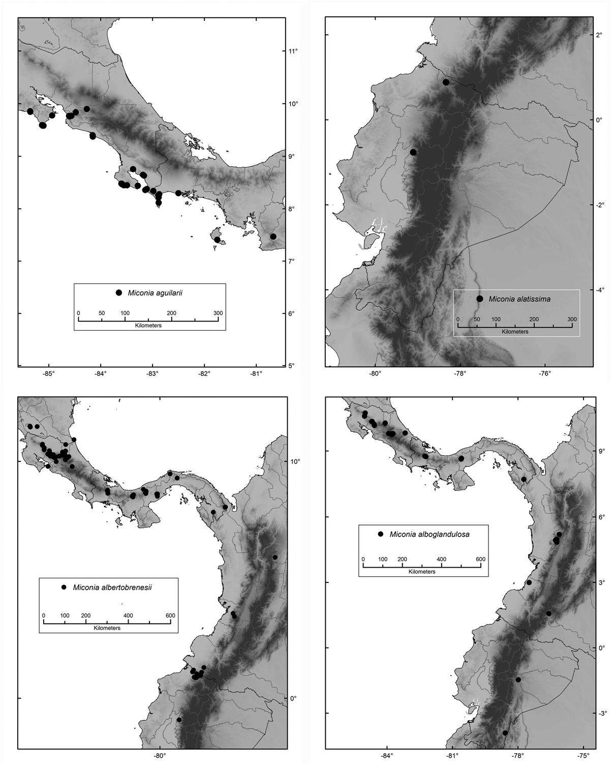
Habitat, distribution and ecology:— Locally common in primary rain forests and cloud forests, growing in the understory usually near stream margins, from Isla de Ometepe in Nicaragua, through southern Central America becoming uncommon in Colombia and Ecuador ( Fig. 11 View FIGURE 11 ), at 100–1700 m. In Colombia and Ecuador it is known from the Pacific Andean slope, with a southernmost population from Cotopaxi in Ecuador.
Manakins, Tanagers, Thrushes, the orange-billed Sparrow ( Arremon aurantiirostris ) and Myadestes melanops have been reported to feed on M. albertobrenesii fruits in a Costa Rican rain forest ( Stiles & Rosselli 1993). The following bird species have also been reported to feed on M. albertobrenesii fruits: Chlorospingus opthalmicus , Corapipo altera , Schiffornis turdina , Tachyphonus delatrii ( Boyle 2006) .
SYSTEMATICS OF THE OCTOPLEURA CLADE OF MICONIA
Phytotaxa 179 (1) © 2014 Magnolia Press 45
Phenology:— Collected in flower and fruit throughout the year.
Etymology:— The specific epithet commemorates Alberto Manuel Brenes (1870–1948), a school teacher in Costa Rica, who collected the type and many other flowering plants in the San Ramón area of Costa Rica over many years.
Discussion:— This species is distinguished by its dense mealy-furfuraceous indumentum, venules that are densely alveolate and conspicuously elevated abaxially, marked asymmetrical plinervation, and berries that are white at maturity. Within the Varibilis subclade, Miconia albertobrenesii is close morphologically and phylogenetically to M. boekei with which it shares the thickened-claviform indumentum and striking plinervation, but clearly distinct from it based on the color of mature berries (white in M. albertobrenesii vs. orange), and other vegetative characters (see M. boekei discussion). It is also similar and closely related to M. neomicrantha which also has white berries, but the flowers are 4-merous (vs. 5-merous), and the indumentum is not mealy. The indumentum of the latter two species is different in structural detail, but both types of trichomes are appressed to the surface, seeming more scale-like (as opposed to the dendritic trichomes that are not appressed and in which the arms are more conspicuous). This scale-like indumentum which is essentially squamate is also found in M. laxivenula (inconspicuous vegetative indumentum) and on the abaxial foliar veins in M. magnifolia . The presence of this kind of indumentum appears to be scattered among species of the Variabilis subclade which suggests that it has evolved several times within this clade.
Conservation status:— Following IUCN criteria ( AOO), this species would be considered Endangered EN B2ab(iii). However, it occurs in many protected areas throughout its range, justifying a status of Least Concern LC. In Colombia it is proctected in the Farallones National Park (Valle) and in the Río Ñambí Natural Reserve (Nariño) . In Costa Rica it is known from the Monteverde Reserve, Volcán Tenorio National Park, the San Ramón Forest Reserve , and the Alberto Brenes Biological Reserve (Alajuela) ; from La Marta Wild Life Refuge (Cartago) ; from the private protected area of Rara Avis Reserve, La Selva Biological Station (Heredia) ; and from the Braulio Carrillo National Park (Heredia, San José and Limón) . In Ecuador it is known from the Awá Indigenous Reserva (Carchi and Esmeraldas) , and from the borders of the Cotacachi-Cayapas Reserve. In Panama it is known from the Palo Seco Protected Forest (Bocas del Toro) ; from the Omar Torrijos National Park (Coclé) ; and from Darién National Park (Darién) .
| HUA |
Universidad de Antioquia |
| MO |
Missouri Botanical Garden |
| US |
University of Stellenbosch |
| COL |
Universidad Nacional de Colombia |
| NY |
William and Lynda Steere Herbarium of the New York Botanical Garden |
| ARIZ |
University of Arizona |
| CAS |
California Academy of Sciences |
| INB |
Instituto Nacional de Biodiversidad |
| CR |
Museo Nacional de Costa Rica |
| PMA |
Provincial Museum of Alberta |
No known copyright restrictions apply. See Agosti, D., Egloff, W., 2009. Taxonomic information exchange and copyright: the Plazi approach. BMC Research Notes 2009, 2:53 for further explanation.
|
Kingdom |
|
|
Phylum |
|
|
Class |
|
|
Order |
|
|
Family |
|
|
Genus |
Miconia albertobrenesii Gamba & Almeda
| Gamba, Diana & Almeda, Frank 2014 |
Leandra lepidota
| Gleason, H. A. 1939: ) |