
Olax emirnensis Baker
|
publication ID |
https://doi.org/ 10.5281/zenodo.5186864 |
|
persistent identifier |
https://treatment.plazi.org/id/03E187E9-F604-FFEA-188E-3CA048F6F96B |
|
treatment provided by |
Carolina |
|
scientific name |
Olax emirnensis Baker |
| status |
|
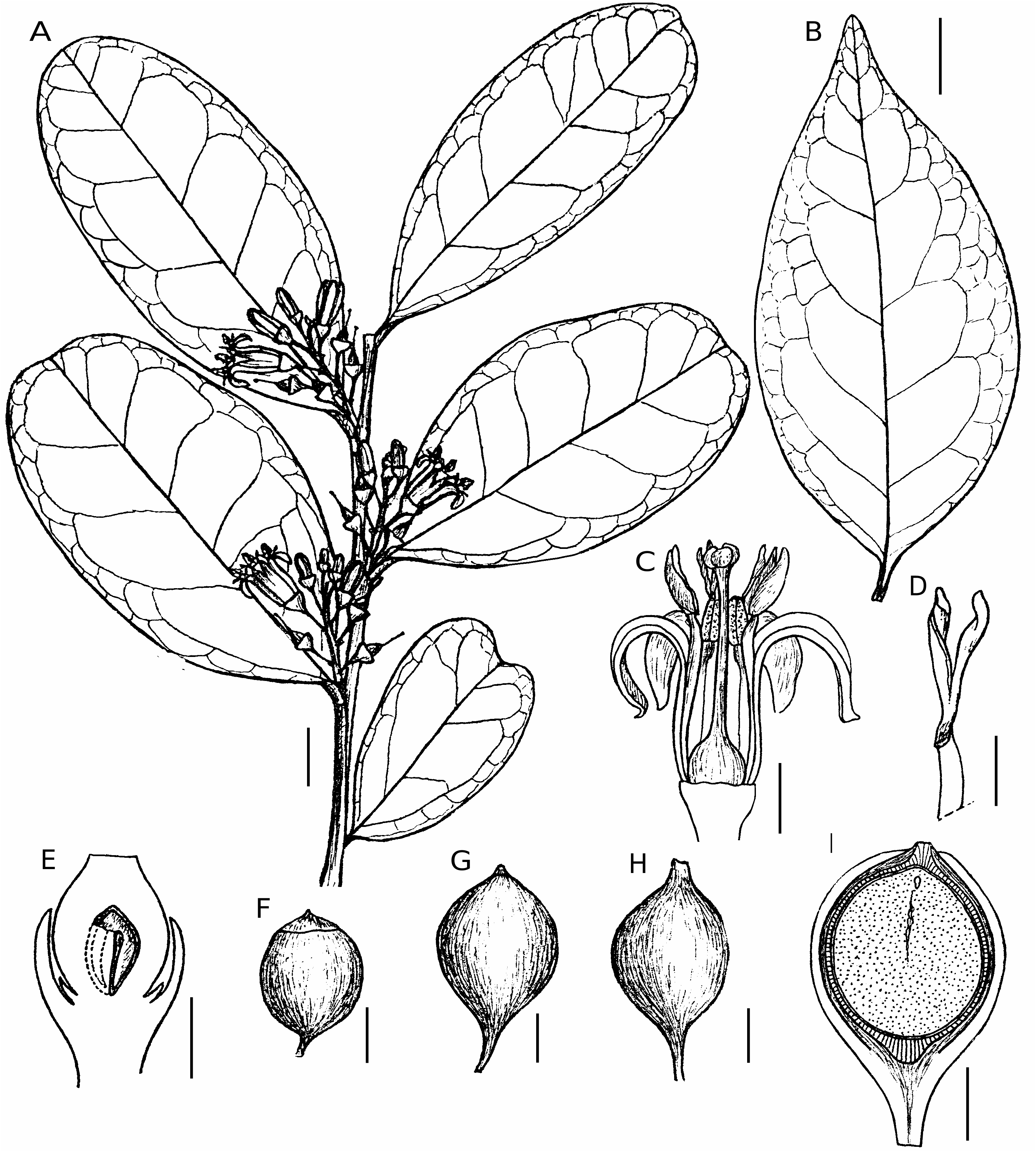
4. Olax emirnensis Baker View in CoL
( Fig. 4 View FIG )
Journal of the Linnean Society, Botany 21: 331 (1884). — Type: Madagascar, central Madagascar, fl., Baron 3078 (holo-, BM!; iso-, K!, P!).
Olax tsaratananensis Cavaco & Keraudren, Boletim da Sociedade Broteriana View in CoL , sér. 2, 29: 25 (1955). — Type: Madagascar, Prov. Antsiranana, Tsaratanana GoogleMaps , [13°49’S, 48°44’E], 1500 m, X.1912, imm. fr., fr., Perrier de la Bâthie 2008 (holo-, P!); syn. nov.
ADDITIONAL MATERIAL EXAMINED. — Madagascar. Prov. Antananarivo, Ambohitantely RS, [18°05’S, 47°16’E], X.1955, fl., Bosser 8518 (MO!, TAN!) GoogleMaps . — Manankazo STF, Manankazo au NE d’Ankazobe, [18°09’S, 47°14’E], 1500 m, 1913, fl., Perrier de la Bâthie 2243 (P!). — Andreba, Fiv. Anjozorobe, Commune Betatao, Forêt de Besofina, à 8 km au Sud de Betatao , et 6 km N d’Andreba, 18°15’10”S, 47°53’27”E, 1386 m, 9.III.2000, fr., Randrianaivo et al. 516 (MO!, P!, TAN) GoogleMaps . — Same locality, 18°15’54”S, 47°52’58”E, 1412 m, 12.III.2000, fr., Randrianaivo et al. 527 (MO!, P!, TAN) GoogleMaps . — Ambohitantely RS, sur le tampoketsa d’Ankazobe, [18°05’S, 47°16’E], 29.X.1967, fl., SF (Capuron) 27814 (P!, TEF!) GoogleMaps . — Tsimanahirivotra, massif de Tsimanahirivotra, au N d’Anjozorobe, [18°16’S, 47°54’E], 1.XI.1967, fl., SF (Capuron) 27817, (P!, TEF!) GoogleMaps . — Ambohitantely RS, sur le Tampoketsa d’Ankazobe, [18°09’S, 47°18’E], 25.II.1968, fr., SF (Capuron) 28270 (P!, TEF!) GoogleMaps . — Same locality, 17.I.1981, fr., SF 34280 ( TEF!) .
Prov. Antsiranana, Tsaratanana Massif, 14°04’40”S, 48°53’47”E, 882 m, 30.X.2000, fl., Antilahimena et al. 621 ( MO!). — Partie occidentale du Massif du Marojejy (Nord-Est) de la vallée de l’Ambatoharanana au bassin supérieur de l’Antsahaberoka, [14°32’S, 49°36’E], 9.XI-2.XII.1959, fl., Humbert & Saboureau 31530bis (P!). — Same locality, 1300-1400 m, same date, fl., Humbert & Saboureau 31742 (P!). — Manongarivo RS, Antsatrotro, [14°05’S, 48°23’E], 800 m, XI.1954, fr., SF (Capuron) 11503 (P!, TEF!) GoogleMaps .
Prov. Fiananarantsoa , Mahabo-Mananivo, forêt de Analazaha, 23°12’38”S, 47°43’47”E, 25 m, 19.II.2003, fr., Ludovic et al. 252 (G!, MO!, P, TAN). — Mahabo, S of Farafangana, near village of Mahabo, 23°10’51”S, 47°42’29”E, 30 m, 5.XI.2001, imm. fr., McPherson & Rabenantoandro 18333 (BR!, K!, MO!, P, TEF, US!). — Iabomary, forêt littorale sur latérite, 40 km au SO de Farafangana, Mananivo, 23°03’34”S, 47°40’23”E, [0- 50 m], 6.II.2001, fr., Rabenantoandro et al. 426 (G!, K!, MO!, P!, TAN) GoogleMaps . — Mahabo-Mananivo , Fivondronana Farafangana, Firaisana Mahabo-Mananivo, 23°12’00”S, 47°42’26”E, 17 m, 6.XI.2001, imm. fr., Rabenantoandro & McPherson 699 (MO!, P[2]!, TEF) GoogleMaps . — Same locality, 23°10’20”S, 47°42’23”E, 29 m, 23.IX.2002, fl., Rabenantoandro et al. 963 (BM!, GRA!, MO!, P!, TEF, WAG!). — Same locality, 23°10’12”S, 47°41’54”E, 5.II.2001, fr., Rabevohitra & Rabenantoandro 3788 [= SF 35378] (MO!, TEF!) GoogleMaps . — Farafangana , près de Farafangana, [22°49’S, 47°49’E], 15.X.1964, fl., SF (Capuron) 23569 (P!, TEF!) GoogleMaps .
Prov. Mahajanga, Besakay, source de la rivière Besakay,canton Betrandraka , districtTsaratanana, [16°59’S, 47°31’E], 16.III.1957, fr., SF (Laoza) 16923 (P!, TEF!) GoogleMaps .
Prov. Toamasina , Toamasina, 3-5 m, 11.X.1946, bud, Cours (Herbier de la station agricole de l’Alaotra) 2966 (MO!, P!, TAN!) . — Marankoditra [= Andranokoditra], forêts côtières de l’Est, [18°36’S, 49°15’E], fl., Louvel 192 (P!). — Tampina, forêt de Tampina, [18°31’S, 49°17’E], XI.1923, fl., Louvel 206 (P!). — Vohibola, c GoogleMaps . 2 km W of Andranokoditra , 18°35’46”S, 49°14’06”E, 2-5 m, 9.II.2003, fr., Lowry et al. 6040 ( MO!) GoogleMaps . — Île Sainte- Marie, Lokintsy, forêt d’Ambohidena, 16°51’11”S, 49°57’10”E GoogleMaps , 10 m, 13.V.2003, fr., McPherson et al. 18906 (BM!, MO!, P, TEF). — Antanambao, N of Soanierana- Ivongo, near village of Antanambao-Ambodimanga, 16°45’28”S, 49°42’59”E GoogleMaps , 10 m, 19.V.2003, fr., McPherson et al. 18955 (MO!, P, TEF, WAG!) . — Ambila Lemaitso , 18°48’S, 49°09’E, 0 m, 15.XI.1989, fl., Miller & Keating 4540 (MO). — Same locality GoogleMaps , 10 m, 16.I.1999, fr., Miller & Lowry 10461 (G!, MO!, TAN) . — Brickaville , [18°50’S, 49°04’E], XI.1921, fl., imm. fr., Perrier de la Bâthie 14074 (P!). — Ambohidena , Fivondronana Sainte-Marie , Firaisana Lokintsy, Fokontany Ambohidena, 16°51’11”S, 49°57’10”E, 1.VI.2004, fl., Rabehevitra & Poity 1111 (B!, MO!, P, TEF). — Antanambao-Ambodimanga, Fivondronana Soanierana-Ivongo, Commune Manompana, forêt sur sables d’Antanambao-Ambodimanga, 16°45’40”S, 49°42’35”E, 1.II.2003, fr., Rabevohitra et al. 4362 (BM!, K!, MO!, P!, TEF) GoogleMaps . — Vohibola forest , Brickaville, 18°35’42”S, 49°14’02”E, 10.II.2003, fr., Rabevohitra et al. 4390 (MO!, P, TEF!) GoogleMaps . — Ambatovy , Phelps Dodge project site, on the road towards Torotorofotsy, 18°52’S, 48°20’30”E, 1000 m, 21.I.1997, fr., Rakotomalaza et al. 973 (MO!, P, TAN) GoogleMaps . — Analamay , Phelps Dodge project site, Analamay, 18°49’26”S, 48°20’16”E GoogleMaps , 1000 m, 26.I.1997, fr., Rakotomalaza et al. 994 (MO!, P!). — Ambila Lemaitso, coastal dune forest just N of railroad bridge, W of pangallane (canal), 18°51’S, 49°08’E, 0-25 m, 28.I.1993, fr., Schatz et al. 3429 (G!, MO!, P!, TAN!). — Tampolo STF , 9 km N of Fénérive , 17°17’15”S, 49°25’11”E GoogleMaps , 10 m, 27.XI.1994, fr., Schatz et al. 3620 (MO!, P!). — Same locality, 2.V.1956, fl., Service Agricole 1043 (MO[2]!, TAN [2]!). — Same locality, fl., SF (Capuron) s. n. (P!). — Ambila Lemaitso STF, forêt d’Ambila, Brickaville, [18°49’S, 49°08’E] GoogleMaps , 7 m, 25.I.1951, fr., SF (Randrianjanaka) 1116 ( TEF!) . — Menagisy STF, [18°52’S, 49°04’E], 0-50 m, 28.II.1951, fr., SF (Verdet) 3211 ( TEF!) GoogleMaps . — Ambila Lemaitso STF, [18°49’S, 49°08’E], 25.IX.1952, fl., SF (Capuron) 5692 (P!, TEF!) GoogleMaps . — Same locality, 29.XII.1952, fr., SF (Rabetsitonta) 6478 (P!, TEF!) . — Tampolo STF, Fénérive- Est, [17°17’S, 49°23’E], 10.IV.1954, fl., SF 10051 (P!, TEF!) GoogleMaps . — Same locality, 24.VIII.1954, fr., SF (Pierre) 10825 (P!, TEF!) . — Same locality, 2.V.1956, fl., SF 15895 (P!, TEF!) . — Same locality, 26.IX.1956, fr., SF (Zavah) 16100 (P!, TEF!) . — Ambila Lemaitso STF, Brickaville, [18°49’S, 49°08’E], 24.II.1958, fr., SF (André) 19003 (P!, TEF!) GoogleMaps . — Mangalimaso , forêt de Mangalimaso, à l’Ouest de Foulpointe, [17°41’S, 49°29’E], 23.XI.1962, fr., SF (Capuron) 22090 (P!, TEF!) GoogleMaps . — Mananara Avaratra PN, Sud de Mananara , [16°26’S, 49°50’E], 10-14.XI.1964, fr., SF (Capuron) 23760 (P!, TEF!) GoogleMaps . — Ambila Lemaitso , [18°49’S, 49°08’E], 14.XII.1967, imm. fr., SF (Capuron) 28033 (P!, TEF!) GoogleMaps . — Île Sainte-Marie , forêt d’Ampanihy, [18°49’S, 49°08’E], 17.V.1969, fl., imm. fr., SF (Capuron) 28850 (P[3]!, TEF!) GoogleMaps . — Andranokoditra , Akanin’ny Nofy , Ambila, Brickaville, 18°36’S, 49°15’E, 25.XI.1983, imm. fr., SF (Rabevohitra) 32536 ( TEF!) GoogleMaps .
Prov. Toliara, Mandena, 2 km E of Botanic Garden , 24°58’S, 47°00’E, 15 m, 9.X.1990 GoogleMaps , fl., Faber-Langendoen et al. 2185 (MO!, P!, TAN!). — Analalava, a few km NW of Manantenina, forêt d’Analalava , 24°13’S, 47°21’E, 40 m, 28.X.1989 GoogleMaps , imm. fr., McPherson 14275 (MO!, P!, TAN!, TEF). — Mandena , NE of Fort-Dauphin, 24°57’S, 47°00’E, 25 m, 7.XII.1989 GoogleMaps , fr., McPherson & Dumetz 14658 (MO!, P!, TAN!, TEF). — Sainte-Luce, near village of Ste. Luce ( Manafiafy ), 24°47’S, 47°10’E GoogleMaps ,
20 m, 16.I.1990, fr., McPherson et al. 14821 (MO!, P!, TAN!). — Mandena, forêt littorale, 24°56’27”S, 47°01’40”E GoogleMaps , 15 m, 28.XI.2002, fr., Randrianaivo et al. 851 (MO!, P, TAN). — Same locality, 24°57’16”S, 46°59’20”E GoogleMaps , 10 m, 19.I.2006, ster., Rogers et al. 905 (MO!, TAN!). — Bemangidy, entre les fleuves Vato-
mena et Manambato , au N de Fort-Dauphin, [24°34’S, 47°12’E], 14.XII.1968, fr., SF (Capuron) 28661 (P!, TEF!) GoogleMaps . — Mandena STF, au N de Fort-Dauphin, [24°57’S, 47°00’E], 14.XII.1969, ster., SF (Capuron) 29013 (P!, TEF!) GoogleMaps . — Same locality, 1.XII.1997, fr., SF (Rabevohitra) 35032 ( TEF!) .
DESCRIPTION
Olax emirnensis has flowers with 4 (rarely 5 or 6) petals, 3 (rarely 4 or 5) stamens, 5 (rarely 4 or 6) staminodes, and a strongly accrescent calyx in fruit. The species differs from the most morphologically similar Malagasy species, O. dissitiflora , by its coriaceous (vs. membranous-chartaceous or semi-succulent) leaves, inconspicuous venation that is rarely represented by faint secondaries (vs. all orders of venation usually visible), by its robust (c. 1-2 vs. c. 0.5 mm in diam.) leaf petioles darker than the midribs (vs. concolorous), and by its larger (12-17 vs. 6-9 mm in diam.) fruits.
REMARKS
Cavaco & Keraudren (1955b) based the name Olax tsaratananensis on a single collection from the Tsaratanana massif. Capuron (1968), with his extensive collections of Olax and prolific field experience, disagreed with the recognition of O. tsaratananensis as a distinct entity. While some vegetative characters vary noticeably among specimens collected from different areas of the island, the consistency observed in floral, fruit, and several other leaf characters (e.g., texture, venation, petiole morphology) allow us to circumscribe a single cohesive taxon, that includes the type of O. tsaratananensis .
DISTRIBUTION AND PHENOLOGY
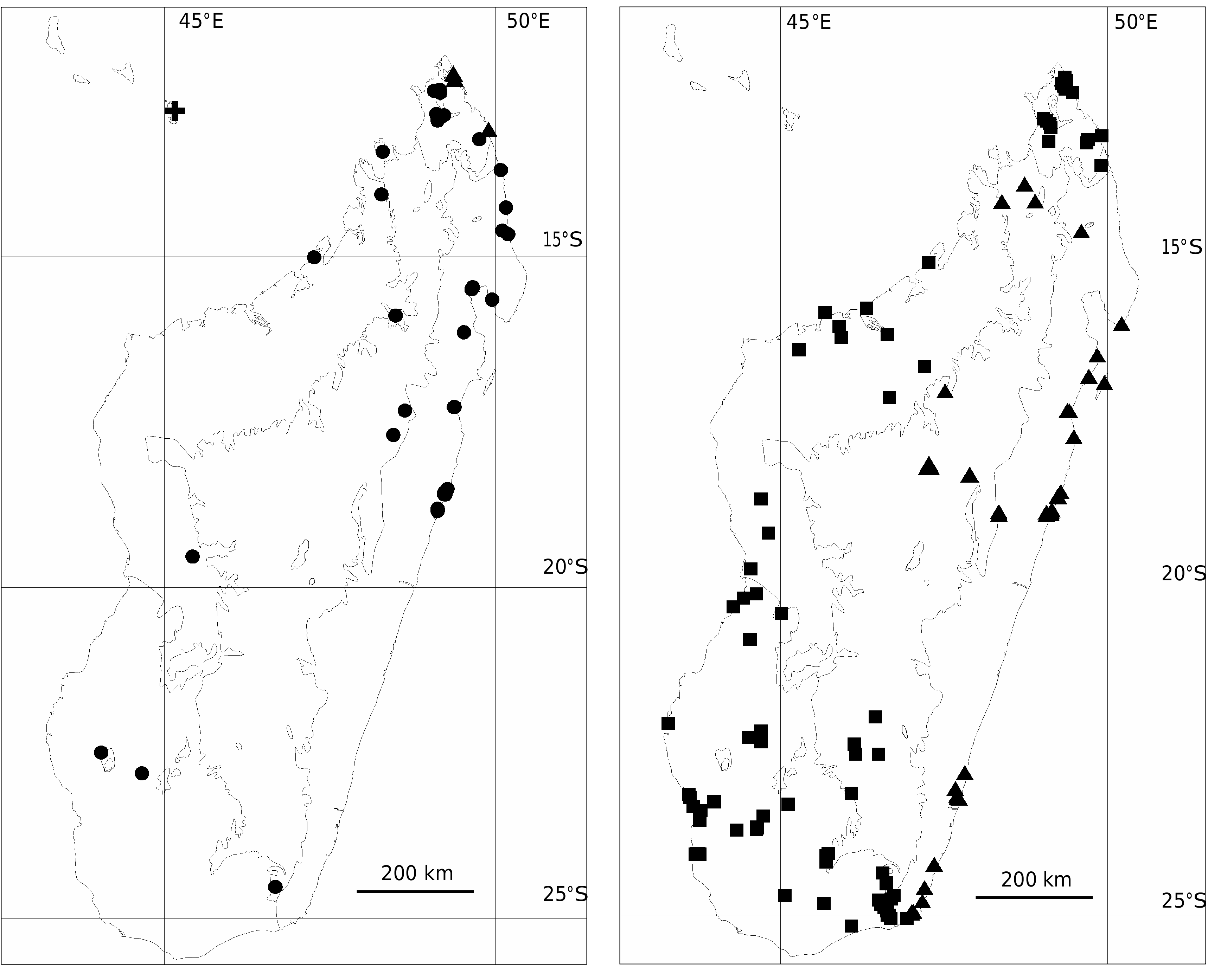
Olax emirnensis occurs from 0 to 1500 m elevation, along most of Madagascar’s east coast (from the northern side of the Masoala peninsula south to Fort-Dauphin) in littoral forest on sand, and in subhumid forest along the central plateau on laterite and granite (from Manongarivo to Marojejy, and south to Ambohitantely and Andasibe- Moramanga; Fig. 10 View FIG ). Olax emirnensis has been recorded in flower from April through June and from September to November. The species fruits from August through June.
VERNACULAR NAMES
Androvola (Cours 2966); Maitsoririnina (SF 10051, 10825, 15895, 16100); Manarimbitana à grandes feuilles (SF 32536); Raisongo (SF 1116, 3211); Soazanahary (Rabenantoandro et al. 963);
| TAN |
Parc de Tsimbazaza |
| TEF |
Centre National de la Recherche Appliquée au Developement Rural |
| MO |
Missouri Botanical Garden |
| GRA |
Albany Museum |
| WAG |
Wageningen University |
No known copyright restrictions apply. See Agosti, D., Egloff, W., 2009. Taxonomic information exchange and copyright: the Plazi approach. BMC Research Notes 2009, 2:53 for further explanation.
|
Kingdom |
|
|
Phylum |
|
|
Class |
|
|
Order |
|
|
Family |
|
|
Genus |
Olax emirnensis Baker
| Rogers, Zachary S., Malécot, Valéry & Sikes, Kendra G. 2006 |
Olax tsaratananensis
| Cavaco & Keraudren 1955: 25 |