
Olax dissitiflora Oliv.
|
publication ID |
https://doi.org/ 10.5281/zenodo.5186864 |
|
persistent identifier |
https://treatment.plazi.org/id/03E187E9-F601-FFE9-1883-39D34826FAAE |
|
treatment provided by |
Carolina |
|
scientific name |
Olax dissitiflora Oliv. |
| status |
|
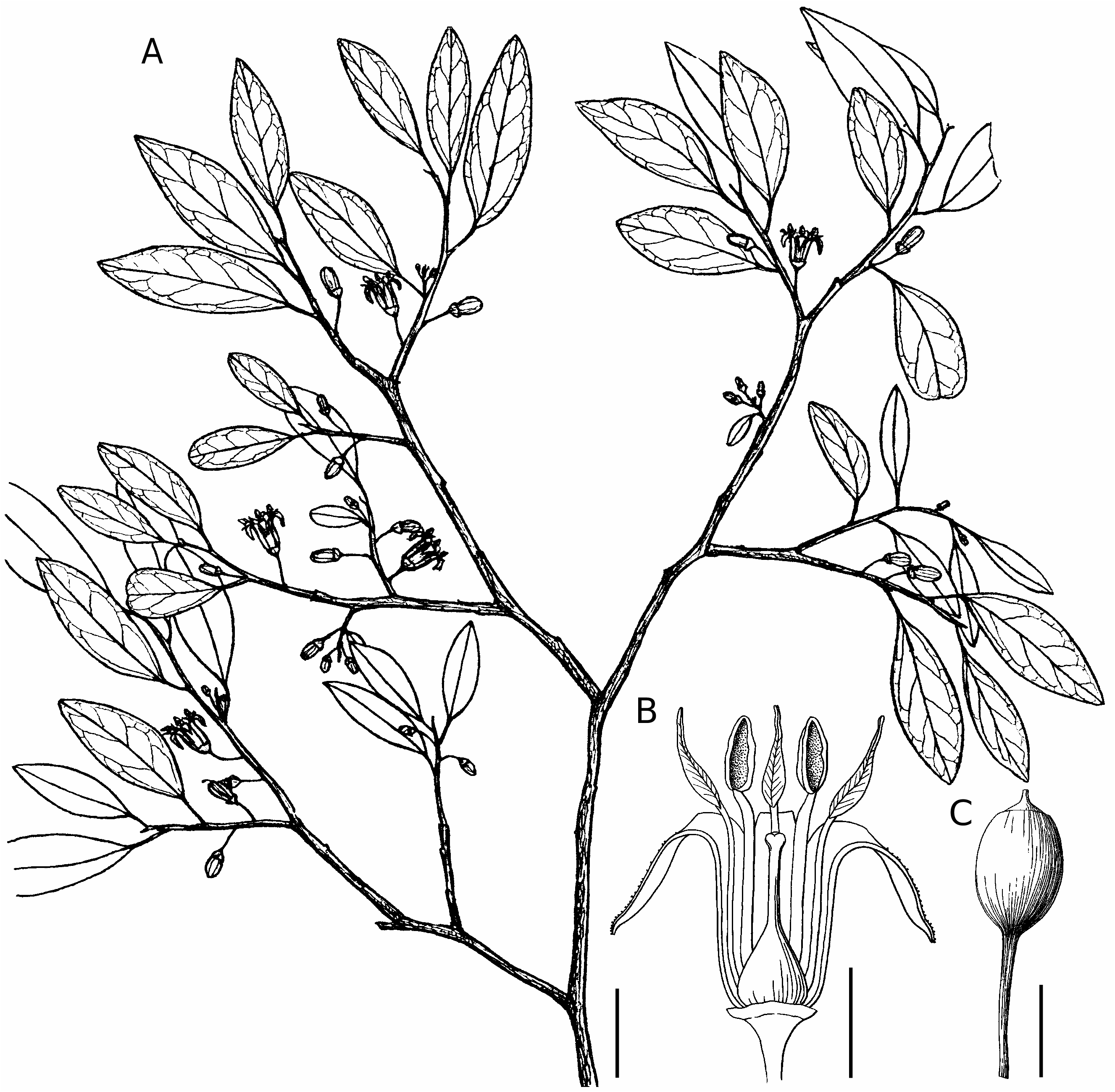
3. Olax dissitiflora Oliv. View in CoL
( Fig. 3 View FIG )
Flora of Tropical Africa 1: 350 (1868) . — Type: Mozambique, Sena , X.1858, Kirk s. n. (lecto-, K-000198748!, left-hand specimen, designated by Garcia 1963).
Olax andronensis Baker View in CoL , Journal of the Linnean Society, Botany 25: 306 (1889). — Type: Madagascar, “province of Androna”, fl., Baron 5548 (holo-, K!; iso-, P!).
Olax stuhlmannii Engl., Notizblatt View in CoL des K. Botanischen Gartens und Museums zu Berlin 2: 283 (1899). — Type: Tanzania, Pwani Region, Kisarawe District, Usaramo, Mkurutuni GoogleMaps [= Kurutuni], [6°57’S, 39°09’E], 100 m, IX.1894, fr., Stuhlmann 8562 (lecto-, herbarium not cited, designated by Garcia 1963). See Remarks.
ADDITIONAL MATERIAL EXAMINED. — Madagascar. Without precise locality, 1847-1852, fr., Boivin 2617 p.p.
Prov. Antsiranana , Montagne des Français, 6 km S of Ramena Beach, 12°22’S, 49°21’E, 175 m, 9.XI.1993, fl., fr., Almeda 7358 (CAS, MO!) GoogleMaps . — Ankarana RS, campement des Anglais , 12°55’S, 49°09’E, 50-409 m, 12-20.X.1993, fl., Andrianantoanina & Rochsceohclher 375 (G!, MO [2]!, P!, TAN). — Ankarana massif, tsingy du lac vert, 5.XI.1990, fl., Bardot-Vaucoulon 242 (P!). — Same locality, 12°54’43”S, 49°06’39”E, 15.X.1997, fl., Bardot- Vaucoulon & Andrianantoanina 772 (P[2]!). — Same locality, 12°53’09”S, 49°06’40”E, 130 m, 23.X.1997, fl., Bardot-Vaucoulon & Andrianantoanina 857 (K, MO!, P[2]!, TAN) GoogleMaps . — Montagne des Français , Betahitra, 12°19’32”S, 49°20’11”E, 310 m, 25.XI.1996, fr., Labat et al. 2820 (K, MO!, P!, TAN!, WAG) GoogleMaps . — Ankarana RS, 12°51’S, 49°04’E, 100-200 m, 22-26.XI.1992, fr., Malcomber et al. 1906 (MO!, P!, TAN!) GoogleMaps . — Mantamena , part of Bekaroaka Range, 7 km NE of Daraina (Vohémar), 13°08’S, 49°42’E, 150 m, 5.XII.1989, fr., Meyers & Boltz 7 (MO!, P!, TAN) GoogleMaps . — Same locality, 112-330 m, 26.X.1990, fl., Meyers 201 (MO!, P!, TAN!) . — Same locality, 26.XI.1990, fr., Meyers 216 (MO!, TAN) . — Ramena , Fivondronana Antsiranana I, Firaisana Ramena , Forêt de Babaomby , 12°11’01”S, 49°20’45”E, 97 m, 31.VIII.2001, bud, Rabenantoandro & Razanatsoa 596 (G!, MO!, P, TAN!). — Analabe forest, Fivondronana Vohémar, Fokontany Anjiabe, près du lac Sahaka, 13°04’55”S, 49°54’34”E, 4.XI.2002, fl., imm. fr., Rabevohitra et al. 4259 (G!, MO!, P!, TEF, US!). — Orangéa, à l’Est de Diégo-Suarez, 12°14’S, 49°22’E, 118 m, X.1975, bud, Rakotozafy 1510 ( TAN!) GoogleMaps . — Ampondrahazo , forêt d’Ampondrahazo, canton de Mahavanona, 12°25’S, 49°28’E, 0-50 m, X.1975, fl., Rakotozafy 1576 ( TAN!) GoogleMaps . — Daraina (Vohémar), 13°11’S, 49°41’E, 175 m, 19.X.1988, fl., Rakotozafy & Raharilala 2280 ( TAN!) GoogleMaps . — Fivondronana Ambilobe , Commune Tanambao-Marivorahona , Fokontany Ananjaka , Forêt de Tsiandrotonana, près du village d’Ankatsaka Anda- vakoera, 13°04’57”S, 49°11’30”E, 57 m, 8.XI.2004, fr., Randrianaivo et al. 1103 (MO!, P, TAN) GoogleMaps . — Ankarana RS, [12°55’S, 49°09’E], 28.XI.1952, fr., SF (Belin) 6179 (P!, TEF!) GoogleMaps . — Baie de Diégo-Suarez , [12°17’S, 49°18’E], 15.X.1955, fl., SF (Belin) 14882 (P!, TEF!) GoogleMaps . — Montagne des Français , sommet de l’Anosiravo, [12°19’S, 49°20’E], 350 m, 7.XI.1961, fl., SF (Capuron) 20354 (P!, TAN!, TEF!) GoogleMaps . — Ambohipiraka , Sud de l’Ambohipiraka (Ambilobe), [13°10’S, 49°06’E], 13.X.1966, fl., SF (Capuron) 24844 (P!, TEF!) GoogleMaps . — Bezavona , massif de Bezavona, entre la Fanambana et la Manambery, [13°32’S, 49°54’E], 13.XII.1966, fr., SF (Capuron) 27237 (P!, TEF!) GoogleMaps . — Montagne des Français , [12°22’S, 49°21’E], 10.XI.1979, fl., SF (Rabevohitra) 29580 ( TEF [2]!). — Same locality and date, fl., fr., SF (Rabevohitra) 29581 ( TEF [2]!). — Ankarana RS, forêt Ampondralatsaka, ouest du village Mahamasina, [12°57’S, 49°08’E], 15.XI.1979, fl., fr., SF (Rabevohitra) 29645 ( TEF [3]!). — Montagne des Français, sur marnes du Cénomanien, route de Ramena, p.k. 8, [12°22’S, 49°21’E], 22.VIII.1980, fl., SF (Rabevohitra) 29938 ( TEF [2]!) GoogleMaps .
Prov. Fiananarantsoa , Vallée d’Ihosy , [22°32’S, 46°09’E], 700 m, fl., Perrier de la Bâthie 16881 (P!). — Menarahaka, forêt de Menarahaka , Canton Sakalalina, District Ihosy, [22°32’S, 46°30’E], 16.XI.1951, fl., SF 4749 (P!, TEF!) GoogleMaps . — Ihosy STF, Ihosy, [22°23’S, 46°07’30”E], 30.X.1953, fl., SF (Bégué) 7621 (P!, TEF!) GoogleMaps . — Mahasoa , aux environs d’Ihosy, p.k. 531 de la route Ihosy-Fianarantsoa, [21°58’S, 46°27’E], 4.X.1953, bud, SF (Capuron) 8556 (P!, TEF!) GoogleMaps . — Andringitra RNI, Ankorovana , près d’Ankazomby, Antambohobe, [22°07’S, 46°49’E], 15.XI.1967, fl., SF (Rakotoniana) 26507 (P!, TEF!) GoogleMaps .
Prov. Mahajanga, Madirokely, Marovoay , [16°07’S, 46°38’E], IX.1955, fl., Bosser 8406 (MO!, P!, TAN!) GoogleMaps . — Miarinarivo, route Andilamena , [16°36’30”S, 47°12’E], XI.1962, fl., Bosser 16494 (MO!, P!, TAN!) GoogleMaps . — Tsingy de Bemaraha, north of the Manambolo river , 19°09’S, 44°49’E, 50 m, 27.XI.1996, fr., Jongkind et al. 3250 (MO!, WAG) GoogleMaps . — Bemaraha RNI, environs rivière Ambodiria, 1 km d’Ambinda, près d’Antsalova , 18°38’S, 44°42’E, 100-200 m, 5.XII.1992, fr., Labat & Deroin 2313 (MO!, P!, TAN!) GoogleMaps . — Besafotra, affluent de droite du Menavava ( Boina ), [17°05’S, 46°40’E], X.1899, fl., fr., Perrier de la Bâthie 958 (G!, P[4]!). — Same locality, XI.1902, fr., Perrier de la Bâthie 958bis (P!). — Mahajanga, environs de Majunga, [15°43’S, 46°19’E], X.1901, fr., Perrier de la Bâthie 10688 (P!). — Same locality, fr., Perrier de la Bâthie 16881bis (P!). — Namoroka RNI, Andranomavo, Soalala, [16°21’S, 45°17’E], 21.IX.1955, fl., RN (Randriamiera) 7222 (P!, TEF!) GoogleMaps . — Antsely , [16°00’S, 45°54’E], 29.XI.1951, fr., SF (Razanajatovo) 5396 ( TEF!) GoogleMaps . — Manisakomby, Majeramanga, canton Sitampiky , district Ambato-Boéni , [16°10’S, 45°56’E], 8.III.1957, fr., SF (Razafimahandry) 17755 (P!, TEF!) GoogleMaps . — Ambondro-Ampasy, forêt d’Ambondro-Ampasy , [15°01’S, 47°16’E], [50 m], 29.X.1958, fr., SF (Capuron) 18799 (P!, TEF!) GoogleMaps . — Tanjona, CapTanjona, Mitsinjo , [15°47’S, 45°41’E], [0-100 m], 16.X.1963, fl., SF (Therezien) 21388 (P!, TEF!) GoogleMaps .
Prov. Toliara, Ambovombe , [25°10’S, 46°05’E], XI.1956, fl., Bosser 10476 (P!, TAN!) GoogleMaps . — Tuléar, km 45 route Toliara-Tananarive , [23°16’S, 43°59’E], 11.XI.1961, fr., Chauvet 185 (P!, TEF!) GoogleMaps . — Sarodrano, route de Sarodrano, Tuléar , [23°27’S, 43°46’E], 19.IX.1962, fl., Chauvet 343 (P!, TEF!) GoogleMaps . — Massif de l’Angavo à l’Est de Antanimora, [24°50’30”S, 45°48’E], 20.VII.1926, ster., Decary 4528 (P!). — Tsimanampetsotsa Réserve , Lac Manampetsotsa , [24°03’S, 43°43’E], 23.X.1940, imm. fr., Decary 16044 (P!, TAN!) GoogleMaps . — Same locality, 24.X.1940, fr., Decary 16061 (P!). — Vinanibe forêt, préfecture de Fort-Dauphin , [25°03’S, 46°56’E], 100 m, 17.X.1990, fl., Dumetz 1328 (MO!, P!, TAN!) GoogleMaps . — Andohahela RNI (parcelle 3), [25°00’S, 46°40’E], [200-600 m], 17.XI.1990, fr., Dumetz 1419 (MO!, P!, TAN!) GoogleMaps . — Andohahela RNI, à l’ouest de Sakaravy (rivière), 24°51’S, 46°38’E, 100-138 m, 31.X.1994, fr., Eboroke 899 (MO!, P!, TAN) GoogleMaps . — Mangarivo, XI (no year), fl., fr., Grevé 32 (G!, MO!, P[6]!). — Morondava , terrains sablonneux, [20°17’S, 44°17’E], XI.1885, fl., fr., Grevé 78 (MO[2]!, P[9]!, TAN!) GoogleMaps . — Betsako, forêt de Betsako Ankazoabo , [22°11’S, 44°42’E], 500-600 m, 21.XI.1955, fl., Herb. Bot. 1078 ( TAN!) GoogleMaps . — Ampandrandava, crête de Morafeno, [24°05’S, 45°42’E], 750 m, IX.1943, fl., imm. fr., Herbier du Jardin Botanique de Tananarive 6033 (P!). — Sud Madagascar, fl., Herbier Institut Scientifique Madagascar 490 (MO!, TAN!) GoogleMaps . — Andohahela PN, between Tsimelaha and Ambatohabo , 24°56’08”S, 46°37’33”E, 200 m, 9.X.2000, fl., Hoffmann et al. 153 (G!, TAN!) GoogleMaps . — Saint- Augustin, Vallée de l’Onilahy, Baie de Saint-Augustin , [23°33’S, 43°46’E], 10 m, 27.IX.1924, fl., Humbert 2596 (P[2]!). — Plateaux et vallées de l’Isalo, environs de Fanjahira, [23°29’S, 44°44’E], 300-600 m, 9.X.1924, fl., Humbert 2754 (G!, P[4]!). — Plateaux et vallées de l’Isalo, gorges de la Sakamarekely et de la Sambalinieto, [23°18’S, 45°07’E], 500-1000 m, 19.X.1924, fl., Humbert 2872 (G!, P!, TAN!, US!). — Mont Vohipolaka au GoogleMaps N de Betroka (Centre-Sud), [23°08’S, 46°05’E], 1100 m, XI.1933, fl., Humbert 11645 (P!). — Maromby, Vallée de la Manambolo (bassin du Mandrare), [24°21’S, 46°34’E], 300-400 m, XII.1933, fr., Humbert 12769 (P[2]!). — Isomony, Vallée de la Manambolo (bassin du Mandrare), aux environs d’Isomonony, [24°31’S, 46°37’E], 400-600 m, XII.1933, fr., Humbert 12816bis (P!). — Same locality, 400-900 m, XII.1933, fr., Humbert 13048 (P!). — Tuléar GoogleMaps , 35-50 km N of Tuléar , 23°12’S, 43°37’E, 0-20 m, 11.XI.1989, fr., Keating & Miller 2239 (MO!, P!, TAN!) GoogleMaps . — Tsimanampetsotsa RNI, environs du lac Tsimanampetsa , [24°03’S, 43°45’E], 0-100 m, 23.XI.1960, fr., Leandri & Saboureau 3997 (P!, TAN!) GoogleMaps . — Same locality, 24.XI.1960, fr., Leandri & Saboureau 4020 (P!). — Route d’Ifaty, Nord deTuléar, 23°09’S, 43°36’E, 5.XI.1987, fr., Morat & Raharimalala 7902 (P!). — Beza Mahafaly RS, near Betioky , 23°41’S, 44°38’E, 150 m, 15.XI.1987, fr., Phillipson 2568 (MO!, P!, TAN!) GoogleMaps . — Same locality, 170 m, 1.XII.1987, fr., Phillipson 2651 (MO!, P!, TAN!) . — Tsimanampetsotsa RNI, Lac Tsimanampetsotsa, 24°04’S, 43°46’E, 50 m, 7.X.1990, fl., Phillipson et al. 3715 (G!, MO!, P!, TAN!). — Belo- Manja , [19°42’S, 44°33’E], 10.X.(no year), fl., Rauh 893 ( TAN!) GoogleMaps . — Ankazoabo , 22°17’S, 44°31’E, 400 m, 3.XI (no year), fr., Rauh 1073 ( TAN!) GoogleMaps . — Andohahela PN, [24°53’S, 46°35’E], 25.XI.1953, fr., RN (Rakotoniaina) 5955 ( TEF!) GoogleMaps . — Maromby, Amboasary-Sud , [24°42’S, 46°44’E], 28.X.1962, fr., RN (Rabevazaha) 12188 (P!, TEF!) GoogleMaps . — La Table, 15 km by road E of Toliara along Route Nationale 7, 23°24’S, 43°47’E, 100 m, 3.XI.1987, fr., Schatz et al. 1759 (MO!, P!, TAN!) GoogleMaps . — Kirindy, Préfecture Morondava, c. 60 km by road NE of Morondava, in the Kirindy Swiss forestry concession, 20°05’S, 44°38’E, 45 m, 25-31.X.1990, fl., imm. fr., Schatz 2991 (MO!, P!, TAN!) GoogleMaps . — Antanimora, Namolory, Fort-Dauphin , [24°49’S, 45°40’E], 16.XII.1951, fr., SF 4437 (P!, TAN!, TEF!). — Betioky , sur la route Betioky-Soalara , [23°42’S, 44°20’E], 16.IX.1953, fl., SF (Capuron) 8456 (P!, TEF!) GoogleMaps . — Ranopiso, Manambaro, Fort-Dauphin , [25°03’S, 46°41’30”E], [0-100 m], 19.IX.1954, fl., SF (Rasolofoson) 10905 (P!, TEF!) GoogleMaps . — Ambalarao , 3 km au SE du village du Beahetse, [22°04’S, 43°17’E], 24.X.1954, fl., SF (Valitera) 12249 ( TEF!) GoogleMaps . — Amparahitsa, Amparehitsy, Ambovombe , [24°46’S, 46°30’E], 10.IX.1955, fl., SF 15666 (P[2]!, TEF!) GoogleMaps . — Betsako, Forêt de Betsako, à 6 km environ au Sud du village de Tanandava , [22°21’S, 44°42’E], 700 m, 21.X.1955, fl., SF (Ravelosaona) 15793 ( TEF!) GoogleMaps . — Filanjara, Forêt à 3 km au nord du village Filanjara , canton Ankilizato , district de Mahabo , [20°23’S, 45°01’E], 27.X.1955, fl., fr., SF (Tsimagna) 16393 (P!, TEF!) GoogleMaps . — Betobory [= Betoboro], 1 km à l’Est du village de Betobory , canton et district Befasy Morondava , [20°47’S, 44°32’E], 0-150 m, 26.IX.1956, fl., SF (Rakotovao & Valitera) 16553 (P!, TEF!) GoogleMaps . — La Table, à l’Est et Sud de La Table ( Tuléar ), [23°24’S, 43°47’E], 8.XI.1967, fr., SF (Capuron) 27893 (P!, TEF!) GoogleMaps . — Tranoroa, Menarandra , près de Tranoroa, [24°42’S, 45°04’E], 14.XI.1967, fr., SF (Capuron) 27971 (P!, TEF!) GoogleMaps . — Beraketa, au Sud de Beraketa , [24°11’S, 45°42’E], 18.XI.1967, fr., SF (Capuron) 28016 (P!, TEF!) GoogleMaps . — Bevilany, à l’Est de Bevilany , [25°00’S, 46°38’E], 7.XII.1968, fr., SF (Capuron) 28566 (P!, TEF!) GoogleMaps . — Andranomena RS, forêt d’Andranomena-Marofandilia ( Morondava ), [20°09’S, 44°26’E], 28.XI.1969, fl., SF (Capuron) 28919 (P!, TEF!) GoogleMaps . — Ampandrandava, environs d’Ampandrandava (entre Bekily etTsivory), [24°05’S, 45°42’E], X.(no year), fl., Seyrig 28 (P!). — Morafeno, environs d’Ampandrandava (entre Bekily et Tsivory) GoogleMaps , [24°03’S, 45°44’E], 750 m, IX.1942, fl., Seyrig 75 (P!). — Ampandrandava, environs d’Ampandrandava (entre Bekily et Tsivory), [24°05’S, 45°42’E], XI.1942, fr., Seyrig 75B (P!). — Ambalatsindro GoogleMaps , 40 km NE of Betioky , [23°39’S, 44°38’E], 5.VI.1987, ster., Sussman 186 (MO[2]!). — Same locality, 19.X.1987, ster., Sussman 349 (MO[2]!) GoogleMaps .
DESCRIPTION
Olax dissitiflora ( Fig.3 View FIG ) has flowers with 5 or 6 petals, 3 (rarely 4 or 5) stamens, and a strongly accrescent calyx that almost completely surrounds a relatively small fruit (6-9 mm in diam.). The closest putative relative of O. dissitiflora is the Mayotte endemic, O. mayottensis , but the former is recognized by its smaller, more membranous leaves (2-5 vs. 4.2-10 cm long), slender petioles (c. 0.5 vs. 1-2 mm in diam.), longer, gracile pedicels (0.3-0.5 mm in diam. and longer than, or rarely equal to, the length of the corolla vs. c. 1 mm in diam.and substantially shorter than the corolla), and by its differently shaped fruits (ellipsoid or spheroid vs. ovoid).
REMARKS
Olax dissitiflora View in CoL was treated under its synonym, O. andronensis Baker View in CoL in the Flore ( Cavaco & Keraudren 1955a), with the African name O. stuhlmannii Engl. View in CoL listed in synonymy. Lucas (1968) was the first author to propose that all three binomials were synonymous and to acknowledge the priority of the Oliver name.
DISTRIBUTION AND PHENOLOGY
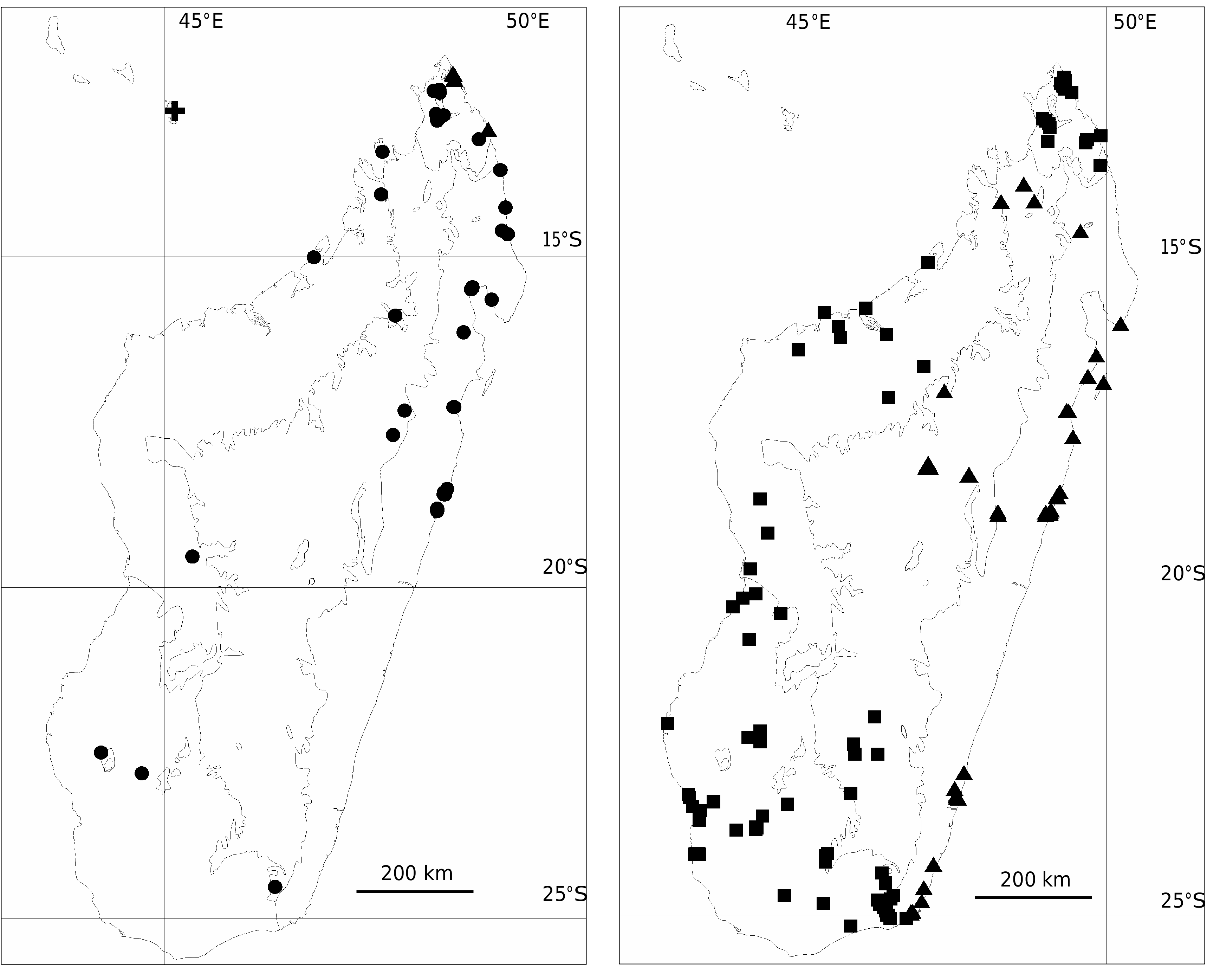
Olax dissitiflora View in CoL is widespread throughout the dry and subarid regions of Madagascar from 0 to 1000 m elevation ( Fig. 10 View FIG ). Populations are generally located in dry forest to the west of the central plateau from the far north to the extreme south, but a few populations reach subhumid forest near Ihosy in Fianarantsoa Province. The species also occurs in Tanzania, Mozambique, and northern South Africa ( Garcia 1963; Lucas 1968; Jordaan 2003). Olax dissitiflora View in CoL flowers from August through November and fruits from September through December. Of the nearly 100 examined collections, a single one falls outside of the range cited. In that case (SF 17755), the plant was evidently fruiting in March.
VERNACULAR NAMES
Ambihotse (SF 10905); Antika (SF 4749); Azopassy (Grevé 32, 78); Hazomalany fotsy (SF 6179); Hazomparasy (Seyrig 28); Hazompasy (SF 12249); Hazomposa (Decary 4528; Laha 243; RN 5955, 12188; SF 4437); Hazondomohina (SF 29645); Hazonganahary (Humbert 11645); Karimbola (Sussman 186); Karimbolabe (Sussman 349); Karimbolamintsy (Sussman 349); Kiran-drambihary (Meyers & Boltz 7); Maitsoririnina (SF 3344); Manarimbitana (SF 29938); Manohilatsaka (SF 15793); Salohimbalala (SF 16393); Tsifetreposa (SF 16553); Tsifolaboay (Herb. Bot. 1078; SF 15793).
USES
Leaves used as a purgative (SF 15793); wood used to make boxes (SF 15793) and as a construction material (SF 16393); unspecified medicinal use (Sussman 186, 349).
CONSERVATION STATUS
Olax dissitiflora is common in Madagascar and adjacent continental African countries. The species has been collected within numerous protected areas in Madagascar (Andohahela, Andranomena, Ankarana, Bemaraha, Beza Mahafaly, Ihosy, Namoroka,Tsimanampetsotsa). Olax dissitiflora should be considered a species of Least Concern (LC).
TYPIFICATION
Several Kirk sheets of Olax dissitiflora , both with and without collection numbers, are deposited at K. Two specimens representing different collections are affixed to one of the unnumbered sheets (K-000198748) and the specimen on the left side should be regarded as the lectotype because it bears the locality and date that corresponds to the information cited in the publication where the lectotypification was first made ( Garcia 1963).
Two collections (Schlechter 11620, Mozambique; Stuhlmann 8562, Tanzania) were cited in the protologue of Olax stuhlmannii . In Flora Zambesiaca, Garcia (1963) placed the name into synonymy with O. dissitiflora and stated that Stuhlmann 8562 was the lectotype collection without mentioning a specific herbarium. Duplicates of the original material of the Stuhlmann collection probably would have been deposited at B and K, but appear to be missing from those herbaria (R. Vogt & V. Noble pers. comm.). In the Flora of Tropical East Africa, Lucas (1968) cited an EA isosyntype of Stuhlmann 8562, but no relevant material has been found in that herbarium (S. Masinde pers. comm.. The second syntype, Schlechter 11620 (B!, BM!, BR!, K!, G[3]!, MO!, P!, WAG!, Z!), definitely belongs to O. dissitiflora . Garcia’s omission of the institution where the lectotype was deposited is not sufficient justification to overturn his lectotypification. We refrain from designating a neotype at this time in hopes that duplicates of Stuhlmann 8562 will be located.
| MO |
Missouri Botanical Garden |
| TAN |
Parc de Tsimbazaza |
| WAG |
Wageningen University |
| TEF |
Centre National de la Recherche Appliquée au Developement Rural |
No known copyright restrictions apply. See Agosti, D., Egloff, W., 2009. Taxonomic information exchange and copyright: the Plazi approach. BMC Research Notes 2009, 2:53 for further explanation.
|
Kingdom |
|
|
Phylum |
|
|
Class |
|
|
Order |
|
|
Family |
|
|
Genus |
Olax dissitiflora Oliv.
| Rogers, Zachary S., Malécot, Valéry & Sikes, Kendra G. 2006 |
Olax andronensis
| Baker 1889: 306 |