
Noronhia humblotiana (H. Perrier)
|
publication ID |
https://doi.org/ 10.5281/zenodo.7599432 |
|
DOI |
https://doi.org/10.5281/zenodo.7586762 |
|
persistent identifier |
https://treatment.plazi.org/id/824F8D54-FFDB-3A6B-FE28-FEE6FA68FB41 |
|
treatment provided by |
Carolina |
|
scientific name |
Noronhia humblotiana (H. Perrier) |
| status |
|
34. Noronhia humblotiana (H. Perrier) View in CoL Hong-Wa, comb. & stat. nov.
≡ Noronhia mangorensis var. humblotiana H. Perrier View in CoL in Mém. Inst. Sci. Madagascar, Sér. B, Biol. Vég. 2: 303. 1949.
Typus: M ADAGASCAR. Prov. Antsiranana: Antakare [Antakarana], [12°54’S 49°08’E], s.d., Humblot 584 (holo-: P [ P00701218 ]!; iso-: K [ K000233185 , K000233186 ] image seen, S [ S09-36009 ] image seen). GoogleMaps
Description
Trees to 10 m tall, trunk to 15 cm diameter; young twigs cylindrical, 0.6-1.3 mm diameter, glabrous; bark dark to medium gray, smooth. Leaves opposite, persistent; bud scales persistent; blades dark green above, lighter below, ovate to oblong, 4.5- 6.5 3 1.5-4 cm, coriaceous, glabrous, domatia absent, base acute to attenuate, margin flat to slightly revolute, apex acuminate, the acumen 3.5-12 mm long, midrib slightly sunken above, distinctly raised below, secondary veins conspicuous, 6-10 per side, 4-12.5 mm apart, looping 1-3.5 mm from the margin; petiole dark to medium gray, 2-7 3 1-2 mm, entirely woody, glabrous. Flowers fasciculate; ped-icel 10-25 mm long, moderately pubescent; calyx moderately pubescent outside, glabrous inside, lobes triangular, 1-2 3 0.9-2 mm; corolla pink to red, urceolate, 4-9.5 mm long, glabrous on both sides, the tube 2.5-6 mm long, lobes ovate, apex obtuse; corona present, 1.5-2.5 mm long, lobed; stamens 1.5-3.5 mm long, anthers obovate, 1.2-1.3 mm long; pistil 2-3.2 mm long, stigma capitate. Fruiting pedicel 12-14 3 0.9-1.1 mm; young fruits green, reddish black when mature, ellipsoid, 9.5 3 7.5 mm, surface rugose, apex flat, style persistent; dry pericarp 0.9 mm thick; endocarp woody.
Distribution, ecology and phenology
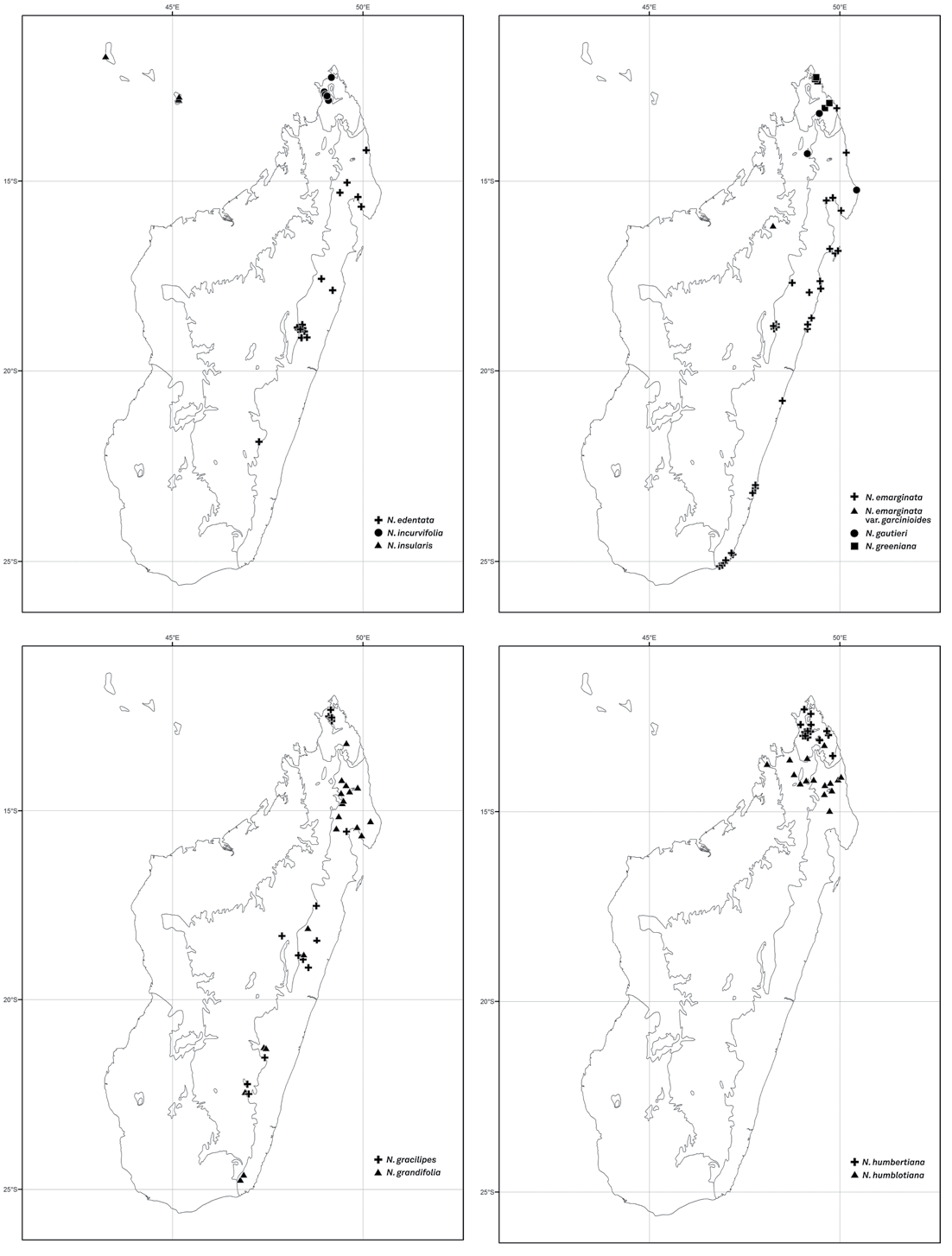
Noronhia humblotiana occurs in mid- to high-elevation humid forests in the north, from Marojejy to Bemafo ( Fig. 19 View Fig ). It produces flowers and fruits from October to May.
Conservation status
Based on 17 collections representing 16 localities, the assessment yielded an EOO of 19,257 km 2, an AOO of 60 km 2, and 15 subpopulations representing 13 loca-tions, of which eight occur within protected areas (Ampasindava, Galoko, Loky-Ma-nambato, Makira, Makirovana-Tsihomanaomby, Marojejy, Tsaratanana, and Tsarata-nana-Ambohimirahavavy-Corridor Marojejy). Despite a relatively narrow distribu-tion and habitat degradation in some of areas, N. humblotiana occurs in more than 10 locations, most of which are encompassed within protected areas. Therefore, this species is assigned a preliminary status of “Near Threatened”.
126 Boissiera 70
Notes
Noronhia humblotiana can be recognized by its coriaceous leaf blades with lighter-col-ored venation, fasciculate, long-pedicellate flowers, and rugose fruits. It was described as a variety of N. mangorensis H. Perrier from which it differs by its flatter and less coria-ceous, acuminate (vs. cuspidate) leaf blades, longer pedicels (10-25 mm vs. 5-13 mm), urceolate (vs. cupuliform) flowers, and ellipsoid (vs. ovoid) fruits.
Additional specimens examined
MADAGASCAR. Prov. Antsiranana: Andapa, Antsahamena , Ambodiangezoka , 14°57’58”S 49°42’54”E, 338 m, 9.XI.2003, Antilahimena 2308 ( G, MO) GoogleMaps ; Antongondriha, massif du Bet-somanga , [14°15’S 49°45’E], 700 m, 17.XI.1950 - 20.XI.1950, Humbert & Capuron 24271 ( G, MO, P) GoogleMaps ; Marojejy PN, 14°27’S 49°47’E, 380 m, 5.X.1988, Miller et al. 3369 ( K, MO, P, TAN) GoogleMaps ; ibid. loc., 14°27’S 49°47’E, 300 m, 2.XII.1989, Miller & Randrianasolo 4645 ( MO, P, TAN) GoogleMaps ; ibid. loc., 14°26’13”S 49°46’32”E, 460 m, 10.X.1996, Rakotomalaza et al. 729 ( G, MO, P, TAN) GoogleMaps ; Sambava, Anjagoveratra, Anamboafo , forêt de Makirovana , 14°09’14”S 49°57’43”E, 481 m, 20.III.2013, Rakotonirina et al. 84 ( MO, P, TAN) GoogleMaps ; Vohémar, Analamazava, 8 km of Ankijabe village , 13°15’43”S 49°35’22”E, 840 m, 25.XI.2004, Ranarivelo et al. 455 ( CAS, MO, TAN) GoogleMaps ; Anjanaharibe-Sud RS, 14°32’45”S 49°35’15”E, 809-1364 m, 25.V-3. VI.1994, Ravelonarivo 138 ( MO, P, TAN) GoogleMaps ; Sambava, Bevontro, Morafeno , forêt d’Antsahandroboka , 14°10’22”S 49°17’54”E, 910 m, 6. II.2006, Razakamalala et al. 3197 ( G, MO, P, TAN) GoogleMaps ; Bet-somanga, Anjanabe , [14°15’30”S 49°44’00”E], 700 m, 18.XI.1950, Service Forestier 832 ( P, TEF) GoogleMaps ; Bemafo , [14°12’S 49°06’E], 2000 m, I.1951, Service Forestier 954 ( P, TEF) GoogleMaps . Prov. Maha-janga: Ambohimiravavy, Bemafo , 1781 m, 1.X.2005, Callmander et al. 395 ( G, MO, P, TAN) ; Tsaratanana Massif , [13°57’S 48°52’E], 1800-2000 m, 8. V.1974, Gentry 11581 ( MO, P, TAN). GoogleMaps
| M |
Botanische Staatssammlung München |
| P |
Museum National d' Histoire Naturelle, Paris (MNHN) - Vascular Plants |
| K |
Royal Botanic Gardens |
| S |
Department of Botany, Swedish Museum of Natural History |
| G |
Conservatoire et Jardin botaniques de la Ville de Genève |
| MO |
Missouri Botanical Garden |
| TAN |
Parc de Tsimbazaza |
| CAS |
California Academy of Sciences |
| VI |
Mykotektet, National Veterinary Institute |
| TEF |
Centre National de la Recherche Appliquée au Developement Rural |
| I |
"Alexandru Ioan Cuza" University |
| V |
Royal British Columbia Museum - Herbarium |
No known copyright restrictions apply. See Agosti, D., Egloff, W., 2009. Taxonomic information exchange and copyright: the Plazi approach. BMC Research Notes 2009, 2:53 for further explanation.
|
Kingdom |
|
|
Phylum |
|
|
Class |
|
|
Order |
|
|
Family |
|
|
Genus |
Noronhia humblotiana (H. Perrier)
| Hong-Wa, Cynthia 2016 |
Noronhia mangorensis var. humblotiana
| H. Perrier 1949: 303 |