
Ischnothyreus monteithi, Edward & Harvey, 2014
|
publication ID |
https://doi.org/ 10.1206/865.1 |
|
persistent identifier |
https://treatment.plazi.org/id/E466E016-FFC9-FFDB-FD36-7E363FB6FB5B |
|
treatment provided by |
Felipe |
|
scientific name |
Ischnothyreus monteithi |
| status |
sp. nov. |
Ischnothyreus monteithi View in CoL , new species Figures 58–59 View Fig View Fig , map 9
TYPES: AUSTRALIA: Queensland: Male holotype, female allotype and 1 male and 1 female paratypes from Bellenden Ker Range , cable tower 3, 17.26667 ° S, 145.85000 ° E, 1054 m (25–31 Oct 1981, EARTHWATCH/ Qld Museum), deposited in QM (³ holotype: QM S27906 View Materials , PBI _OON 22150; ♀ allotype and 1 ³, 1 ♀ paratype: QM S27906 View Materials , PBI _ OON 5610 ) GoogleMaps .
ETYMOLOGY: The specific name is a patronym in honor of Geof Monteith, in recognition of his enormous contribution to entomology and numerous collections within the Wet Tropics Bioregion.
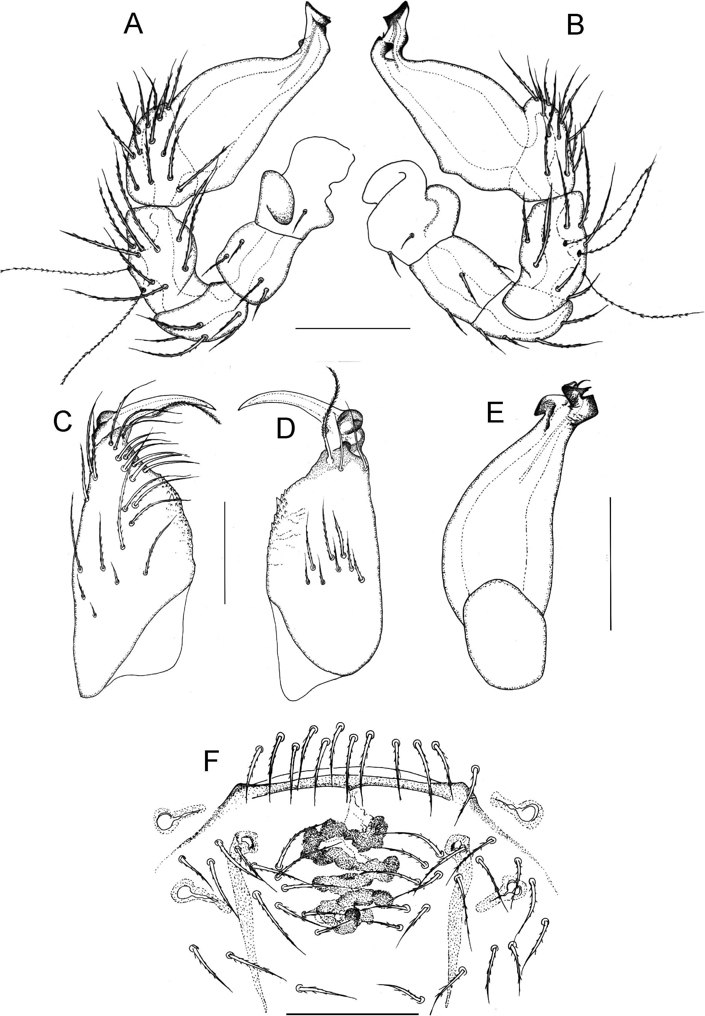
DIAGNOSIS: This species is similar to I. barratus , sp. nov., but can be identified by a rounded disc-shaped basal process on the male cheliceral fang (fig. 59D), a distal concavity on the distal edge of the male palp (fig. 59A, B), the lack of a clear epigynal atrium or sclerotized structure in the female epigynal region, and a long dorsal scute covering 2/3 of the female abdomen.
MALE (PBI_OON 22150, fig. 58 A–C, G, H; paratype (PBI_OON 05633), fig. 59A–E). Total length 1.43. CEPHALOTHORAX: Carapace pale orange to live green, broadly oval in dorsal view, pars cephalica strongly elevated in lateral view, anteriorly narrowed to between 0.5 and 0.75 times its maximum width, anterolateral corners without extension or projections, surface of elevated portion of pars cephalica strongly reticulate, sides strongly reticulate. Clypeus margin unmodified, curved downward in front view, low, ALE separated from edge of carapace by less than their radius; setae dark. Eyes: ALE largest, ALE circular, PME oval, PLE oval; posterior eye row procurved from above; ALE touching, ALE-PLE touching. Sternum longer than wide, pale orange, uniform; setae dark, evenly scattered. Chelicerae, endites, and labium pale orange. Chelicerae slightly divergent, anterior face unmodified; promargin with one slightly larger denticle; fang shape normal, with prominent disc-shaped basal process; setae dark. Labium elongated hexagon, not fused to sternum, anterior margin indented at middle, slightly stronger sclerotization than sternum; with six or more setae on anterior margin. Endites distally not excavated, anteromedian tip with one strong, toothlike projection, stronger sclerotization than sternum. ABDOMEN: Ovoid; dorsum soft portions pale orange. Book lung covers elliptical. Dorsal scutum pale orange, covering more than 3/4 of abdomen, more than 1/2 to most of abdomen width, middle surface finely reticulate, sides finely reticulate. Epigastric scutum small lateral sclerites absent. Postepigastric scutum pale orange, covering about 2/3 of abdominal length. Dorsum, epigastric area, and postepigastric area setae dark. LEGS: Pale orange, without color pattern; patella plus tibia I shorter than carapace. Leg spination: femora: I p0-2-0; II p0-1-0; tibiae: I, II p2-2-0; v2-2-0; metatarsi: I, II p1-1-0; v1-1-0. GENITALIA: Palp proximal segments dark red-brown; embolus dark; femur shorter than trochanter; patella about as long as femur; cymbium dark redbrown,; bulb dark red-brown, more than two times as long as cymbium, stout; embolic region simple, without enlarged or complex processes, shaped like elephant’s trunk, stout, distal edge with concavity (fig. 59A, B).
FEMALE (PBI_OON 5610, fig. 58D–F, I; paratype (PBI_OON 05622), fig. 59F). Total length 1.54. CEPHALOTHORAX: Carapace pars cephalica slightly elevated in lateral view, anteriorly narrowed to 0.49 times its maximum width or less. ABDOMEN: Epigastric scutum small lateral sclerites present. Postepigastric scutum widely hexagonal, only around epigastric furrow. LEGS: Orange. Leg spination: femora: I p0-2-0; II p0-1-0; tibiae: I, II p2-2-0; v2-2-0; metatarsi: I, II p1-1-0; v1-1-0. GENITALIA: Ventral view: epigynal region very simple, no discerning epigynal atrium, without sclerotized projections; convoluted duct very dark, thicker than apodemes (fig. 59F).
OTHER MATERIAL EXAMINED: AUS- TRALIA: Queensland: Bell Peak North , rainforest, 950 m, 17.10000 ° S, 145.88330 ° E, Oct. 13, 1982 (G. Monteith, D. Yeates, G. Thompson, QM S16051 View Materials , PBI _OON 26270), 2 ³, 2 ♀ GoogleMaps ; Bell Peak North , rainforest, 950 m, 17.10000 ° S, 145.88330 ° E, Oct. 13, 1982 (G. Monteith, D. Yeates, G. Thompson, QM S12983 View Materials , PBI _OON 26272), 4 ♀ GoogleMaps ; Bellenden Ker Range , cable tower 3, rainforest, leaf litter, 1054 m, 17.26667 ° S, 145.85000 ° E, Oct. 17–24, 1981 (EARTHWATCH/ Qld Museum, QM S27896 View Materials , PBI _OON 25934), 1 ³ GoogleMaps ; Bellenden Ker Range, Cableway Base Station , rainforest, leaf litter, 100 m, 17.26667 ° S, 145.90000 ° E, Oct. 17–31, 1981 (EARTH- WATCH/ Qld Museum, QM S27758 View Materials , PBI _ OON 25878), 1 ♀ GoogleMaps ; Bellenden Ker Range , summit, rainforest, 1560 m, 17.26472 ° S, 145.85805 ° E, Oct. 08, 1991 (G. Monteith, H. Janetzki, QM S79688, PBI _OON 22175), 1 ♀ GoogleMaps ; Bellenden Ker Range, Summit TV Station , rainforest, 1560 m, 17.26667 ° S, 145.85000 ° E, Nov. 01, 1981, to Nov. 07, 1981 (EARTHWATCH/ Qld Museum, QM S27848 View Materials , PBI _OON 22153), 1 ³ GoogleMaps ; Bellenden Ker Range, Summit TV Station , 1560 m, 17.26667 ° S, 145.85000 ° E, Oct. 28, 1983 (G. Monteith, D. Yeates, G. Thompson, QM S16811 View Materials , PBI _OON 26279), 1 ³ GoogleMaps ; Bellenden Ker Range, Westgid Creek (N Branch ), 100 m, 17.26667 ° S, 145.90000 ° E, Nov. 1, 1981 (EARTHWATCH/ Qld Museum, QM S26274 View Materials , PBI _OON 22154), 1 ♀ GoogleMaps ; Black Mountain , 17 km ESE Julatten, 900 m, 16.65000 ° S, 145.48330 ° E, Apr. 29–30, 1982 (G. Monteith, D. Yeates, D. Cook, QM S16093 View Materials ), 2 ³, 2 ♀ GoogleMaps ; Cardwell Range, Mount Macalister , 900 m, 18.30000 ° S, 145.93330 ° E, Dec. 19, 1986 (G. Monteith, G. Thompson, D. Hamlet, QM S31596 View Materials , PBI _OON 21770), 1 ³ GoogleMaps ; Cardwell SF, Murray Falls boardwalk, rainforest, leaf litter, 18.15250 ° S, 145.81777 ° E, May 2, 2009 (K. Edward and P. Cullen, QM S95973 View Materials , PBI _ OON 5552 ), 1 ³ GoogleMaps ; Charmillin Creek , 940 m, 17.70000 ° S, 145.51670 ° E, Dec. 1, 1997 (G. Monteith, QM S43099 View Materials , PBI _OON 22039), 2 ³, 1 ♀ GoogleMaps ; Chujeba Peak summit, 7 km SW Redlynch, 750 m, 16.93333 ° S, 145.65000 ° E, Dec. 14, 1989 (G. Monteith, G. Thompson, QM S41516 View Materials , PBI _OON 22218), 1 ³ GoogleMaps ; Copperlode Dam Road , rainforest, 16.97500 ° S, 145.70833 ° E, July 23–Nov. 26, 1992 (R. Raven, P. Lawless, E. Lawless, M. Shaw, QM S78927 View Materials , PBI _OON 20882), 1 ♀ GoogleMaps ; Curtain Fig tower, 2 km SW Yungaburra, 750 m, 17.28333 ° S, 145.58330 ° E, Dec. 25, 1989 (G. Monteith, QM S33918 View Materials , PBI _OON 21757), 1 ♀ GoogleMaps ; Douglas Creek, Lamb Range , 900 m, 17.10000 ° S, 145.61670 ° E, Oct. 12, 1982 (G. Monteith, D. Yeates, G. Thompson, QM S16032 View Materials , PBI _ OON 25781), 1 ♀ GoogleMaps ; Lake Eacham , rainforest, 17.28300 ° S, 145.63300 ° E, Dec. 9, 1989 (G. Monteith, G. Thompson, H. Janetzki, QM S79687, PBI _OON 22178), 2 ♀ GoogleMaps ; Lambs Head, East end, 1180 m, 17.03333 ° S, 145.66670 ° E, Nov. 29, 1993 (G. Monteith, H. Janetzki, QM S34824 View Materials , PBI _OON 22023), 1 ♀ GoogleMaps ; Maalan Road , 2 km S Palmerston highway, 17.60000 ° S, 145.70000 ° E, May 18, 1995 (G. Monteith, QM S41060 View Materials , PBI _OON 21710), 1 ³ GoogleMaps ; Mount Bartle Frere, Sth. Peak summit, 17.40000 ° S, 145.81666 ° E, Nov. 6–8, 1981 (EARTH- WATCH/ Qld Museum, QM S75928, PBI _ OON 25802), 1 ♀ GoogleMaps ; Mount Edith Road , rainforest, 900 m, 17.10500 ° S, 145.61166 ° E, May 30, 2008 (G. Monteith, QM S86446), 1 ♀ GoogleMaps ; Mount Fisher, summit, rainforest, 1360 m, 17.56666 ° S, 145.56666 ° E, Feb. 8, 1999 (G. Monteith, QM S78835 View Materials , PBI _OON 20613), 1 ³, 2 ♀ Mount Fisher, 7 km SW Millaa Millaa, Whiteing Road , 1200 m, 17.55000 ° S, 145.56670 ° E, May 5, 1983, G. Monteith, D. Yeates, 1 ³ ( QM S16119 View Materials PBI _OON 26275) GoogleMaps ; Mount Kooroomool saddle, 7 km S, rainforest, 860 m, 17.90000 ° S, 145.68333 ° E, Dec. 3, 1998 (G. Monteith, QM S78694, PBI _ OON 7155 ), 1 ³ GoogleMaps ; Mount Kooroomool summit, 7 km S, site 2, rainforest, 1000 m, 17.90150 ° S, 145.67580 ° E, Dec. 4, 1998 (G. Monteith, QM S69623, PBI _OON 22241), 2 ♀ GoogleMaps ; Mount Lewis Road , 16 km from highway, 950 m, Dec. 18, 1989 (G. Monteith, G. Thompson, QM S29981 View Materials , PBI _OON 21743), 1 ♀ ; Mount Murray Prior, Casuarina , 770 m, 16.93333 ° S, 145.85000 ° E, Dec. 7, 1998 (G. Monteith, QM S78935 View Materials , PBI _OON 20867), 1 ♀ GoogleMaps ; Mount Pieter-Botte summit, 950 m, 16.08333 ° S, 145.40000 ° E, Nov. 21, 1993 (G. Monteith, H. Janetzki, QM S49632, PBI _OON 22133), 1 ³ GoogleMaps ; Mount Williams 0.5 km NW, 870 m, 16.91667 ° S, 145.66670 ° E, Nov. 28, 1997 (G. Monteith, QM S43218 View Materials , PBI _OON 22173), 4 ³ GoogleMaps ; Mount Williams , 1 km ENE, 800 m, 16.90767 ° S, 145.66900 ° E, Dec. 2, 1993 (G. Monteith, H. Janetzki, QM S58217 View Materials , PBI _OON 22138), 1 ♀ GoogleMaps ; Saddle Mountain , 640 m, 16.81667 ° S, 145.66670 ° E, Nov. 3, 1995 (G. Monteith, D. Cook, QM S38705 View Materials , PBI _OON 22238), 2 ♀ GoogleMaps ; Saddle Mountain , 640 m, 16.81667 ° S, 145.66670 ° E, Nov. 3, 1995 (G. Monteith, D. Cook, QM S38704 View Materials , PBI _OON 22239), 3 ³ GoogleMaps ; Sluice Creek , 9 km WSW Millaa Millaa, 1150 m, 17.51667 ° S, 145.51670 ° E, Dec. 5, 1988 (G. Monteith, G. Thompson, QM S16430 View Materials , PBI _OON 25952), 1 ³, 2 ♀ GoogleMaps ; Tooloombah Creek (NQ 41), 22.70500 ° S, 149.56670 ° E, July 29–Nov. 24, 1992 (R. Raven, P. Lawless, E. Lawless, M. Shaw, QM S24642 View Materials , PBI _OON 21983), 1 ³, 1 ♀ GoogleMaps ; Upper Boulder Creek, Walter Hill Range , 1000 m, 17.83333 ° S, 145.90000 ° E, Dec. 7, 1989 (G. Monteith, G. Thompson, H. Janetzki, QM S49688 View Materials , PBI _OON 22135), 2 ³ GoogleMaps ; Vine Creek, Majors Mountain , 1100 m, 17.67633 ° S, 145.53370 ° E, Nov. 24, 1994 (G. Monteith, QM S60285 View Materials , PBI _OON 22075), 1 ³ GoogleMaps ; Wooroonooran National Park, Mount Bartle Frere , western side on track to summit, 1000 m, 17.37833 ° S, 145.78578 ° E, Apr. 23, 2009 (H. Wood, CASENT 9035057, PBI _ OON 00005633 ), 1 ³ GoogleMaps ; Wooroonooran National Park, Mount Bartle Frere , western side on track to summit, 1000 m, 17.37833 ° S, 145.78578 ° E, Apr. 23, 2009 (H. Wood, CASENT 9035053, PBI _ OON 00005622 ), 1 ♀ GoogleMaps .
DISTRIBUTION: This species is relatively widespread from Thornton Uplands in the Wet Tropics Bioregion, south to Rockhampton, Queensland (map 9).

| QM |
Queensland Museum |
No known copyright restrictions apply. See Agosti, D., Egloff, W., 2009. Taxonomic information exchange and copyright: the Plazi approach. BMC Research Notes 2009, 2:53 for further explanation.
|
Kingdom |
|
|
Phylum |
|
|
Class |
|
|
Order |
|
|
Family |
|
|
Genus |