
Hydraena tricantha Zwick, 1977
|
publication ID |
https://doi.org/ 10.11646/zootaxa.1489.1.1 |
|
publication LSID |
lsid:zoobank.org:pub:97D649AF-D141-4FBF-9729-192718525E87 |
|
DOI |
https://doi.org/10.5281/zenodo.5086912 |
|
persistent identifier |
https://treatment.plazi.org/id/038187DB-FF9B-FFE5-FF37-FE17FD0A30E0 |
|
treatment provided by |
Felipe |
|
scientific name |
Hydraena tricantha Zwick, 1977 |
| status |
|
Hydraena tricantha Zwick, 1977 View in CoL
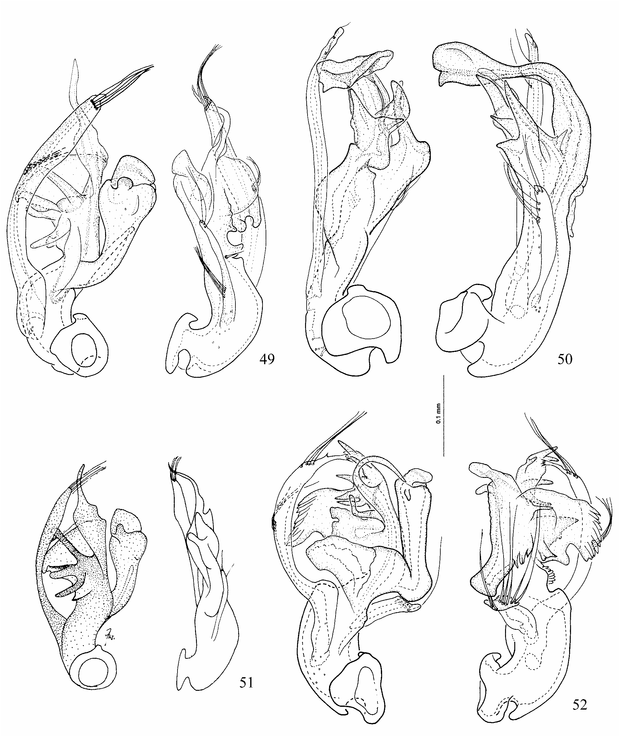
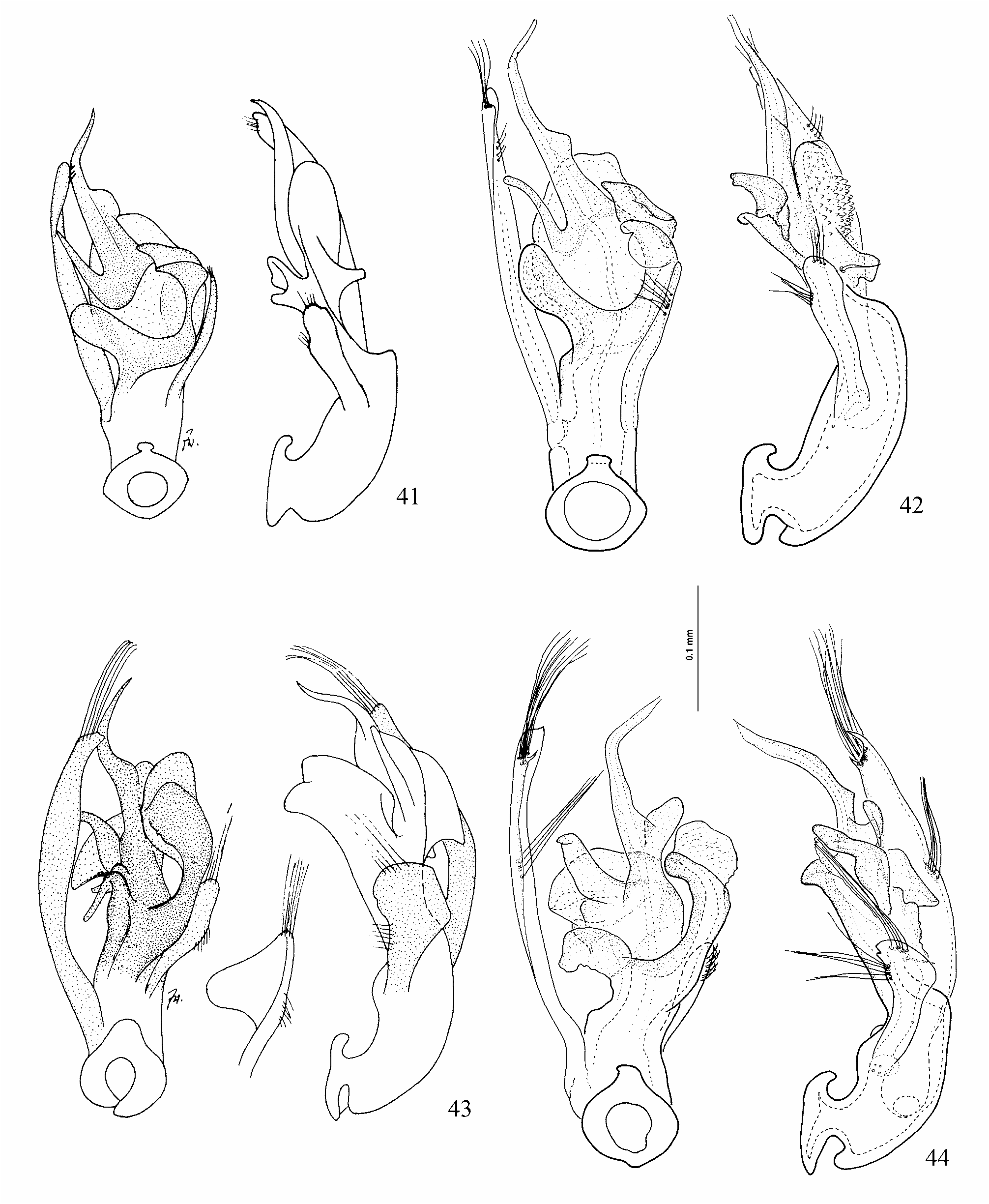
( Figs. 38 View FIGURES 37–40 , 49, 51 View FIGURES 49–52 , 250)
Hydraena tricantha Zwick, 1977: 163 View in CoL .
Type Material. Holotype (male): Victoria, Ovens River at Harrietville [ca. 36° 53' S, 147° 4' E] [labels: Australia, Vic., Ovens R., Harrietville 23.xi.72 Zwick // Hydraena tricantha Zwick Holo-Typus des. P. Zwick 1977 // HOLOTYPE T-12799 Hydraena tricantha Zwick, 1977 // DIGITAL IMAGE captured 2004 P. D. Perkins]. Deposited in the MVMA.
Differential Diagnosis. Similar to H. clavigera in body size and color ( Figs. 38–40 View FIGURES 37–40 ); differing therefrom by the narrower pronotal base, the larger pronotal macula, the less convex elytra, and the narrower, more widely separated plaques. The aedeagi of the two species also suggest a relationship ( Figs. 43, 44 View FIGURES 41–44 , 49, 51 View FIGURES 49–52 ).
Description. Size: holotype (length/width, mm): body (length to elytral apices) 1.52/0.61; head 0.24/ 0.35; pronotum 0.38/0.48, PA 0.41, PB 0.36; elytra 0.89/0.60. Head dark brown, pronotum yellowish with brown macula on disc; elytra brown with yellowish humeri, legs and maxillary palpi light brown to yellowish.
Frons punctures ca. 1–1.5xef; interstices shining, 0.5–3xpd. Clypeus microreticulate laterally, finely sparsely punctate medially. Mentum shining, very finely sparsely punctate; postmentum microreticulate. Genae raised, lacking posterior ridge. Pronotal punctures on disc ca. 1xpd those of frons, interstices shining, 1–4xpd, punctures denser at anterior, similar to frons; PF1 and PF4 absent; PF2 very shallow; PF3 moderately deep.
Elytra weakly humped near midlength, at summit of posterior declivity; on basal 1/3 punctures large, ca. 2–3xpd largest pronotal punctures, becoming gradually smaller toward posterior. Intervals not raised, shining, width over posterior 1/2 ca. 2–3xpd, as are interstices between punctures of a row. Apices in dorsal aspect gradually separately rounded, in posterior aspect margins form shallow angle with one another.
Ratios of P2 width and plaque shape (P2/w/l/s) ca. 1/1/3/3 P1 laminate; median carina straight in lateral view. P2 narrow, l/w ca. 2.5/1, sides parallel, apex blunt. Plaques parallel, narrow lines, located in posterior 0.7 of metaventrite on sides of deep median depression. Low, short midlongitudinal carina between mesoventral intercoxal process and median depression. Cuticle very fine asperite under hydrofuge pubescence. AIS large, flat, width at straight posterior margin 2–3x P2. Protibia thickened near midlength, forming tooth that bears a seta, inner surface between tooth and apex distinctively notched. Meso- and metatibia slender, straight. Last sternite symmetrical, margin very slightly produced apicomedially; last tergite with deep, asymmetrical, apicomedian, concavity.
Aedeagus ( Fig. 49, 51 View FIGURES 49–52 ) main-piece distally extending on right side as very large, complex, knob-shaped process; distal piece with gonopore-bearing flagellum median or nearly so, to the left of which (ventral view) are three or four processes; left paramere arcuate, setae terminally and on dorsal margin at about midlength; right paramere very slender, with about four setae at apex and six setae tightly grouped on ventral margin near basal 1/3. Female last tergite with apicomedian incision delimiting two lobes, setae slender, tapering.
Distribution. Currently known from Victoria, New South Wales, and Australian Capital Territory (Fig. 250).
Material Examined (147): Australian Capital Territory, Gibraltar Falls, mainly wet rockfaces, but also splash zone of rills over rock; sclerophyll forest, elev. 980 m, 35° 29' S, 148° 56' E, 6 April 2001, N. Porch & N. Krause (33) (2 ANIC) GoogleMaps ; New South Wales , Back Creek, Moffatt Falls, ca. 5 km W New England N. P. boundary, ex. seepage rockface at side of Moffatt Falls, 30° 29' S, 152° 20' E, 24 January 1998, P. D. Perkins (1 MCZ) GoogleMaps ; Buckenbowra River , 20 km S Nelligen, 35° 42' S, 150° 1' E, 26 November 2001, A. Glaister (3 SAMA) GoogleMaps ; Currowan Creek , 6 km N of Nelligen, 35° 34' S, 150° 9' E, 26 November 2001, A. Glaister (2 SAMA) GoogleMaps ; Dorrigo N. P., Rosewood Creek , upstream from Coachwood Falls, ex. gravel/sand stream bank, elev. 650 m, 30° 22' S, 152° 40' E, 26 January 1998, P. D. Perkins (8 QMBA) GoogleMaps ; Kosciusko N. P., Leather Barrel Creek , wet sclerophyll forest, flood debris ex large log jam, large forest stream, elev. 980 m, 36° 32' S, 148° 12' E, 19 December 1986, A. Newton & M. Thayer (2 FMNH) GoogleMaps ; Kosciusko N. P., Pipers Creek , NE Guthega, low wet sclerophyll forest, wet leaves and flood debris, forest stream, elev. 1340 m, 36° 21' S, 148° 25' E, 14 February 1987, A. Newton & M. Thayer (832) (3 FMNH) GoogleMaps ; Leather Barrel Ck. , 8 mi. SW of Thredbo, elev. 1066.8 m, 36° 20' S, 148° 35' E, 1 April 1965, M. E. Bacchus (MEB 227) (4 BMNH) GoogleMaps ; Shalhaven River , Bungonia Reserve, 34° 48' S, 150° 0' E, 23 November 2001, A. Glaister (2 SAMA) GoogleMaps ; Unnamed creek drains into Nungatta Creek, 36° 7' S, 149° 29' E, 11 February 1998, J. & R. Miller (site 566a) (1 ANIC) GoogleMaps ; same locality, 21 February 1998, J. & R. Miller (site 566a) (4 ANIC) GoogleMaps ; Victoria , 1 km N Possum Hollow, W branch Tarwin River, 4.6 km SSW Allambee, ex shaded silty mud at edge of small 'creek' at pasture/wet sclerophyll forest boundary, elev. 240 m, 38° 18' S, 146° 1' E, 14 January 1999, N. Porch (NP 19) (1 ANIC) GoogleMaps ; Acheron River along Acheron Way, 37° 28' S, 145° 40' E, 25 May 1975, L. Macmillan (1 PZC) GoogleMaps ; Allambee , 6.2 km SSW of, falls on the West Branch of Tarwin River, seeps and splash-zone of steep rocky cascading 'falls' in wet sclerophyll forest beside road, elev. 220 m, 38° 19' S, 146° 1' E, 9 April 2000, N. Porch (NP 73) (18 ANIC) GoogleMaps ; Base of Trentham Falls , 2.3 km N Trentham, amongst wet gravel at edge of waterfall splash pool and outlet. Dry sclerophyll forest [creek], elev. 640 m, 37° 22' S, 144° 19' E, 31 January 1999, N. Porch (NP 23) (1 ANIC) GoogleMaps ; Cement Creek on Mt. Donna Buang , nr. Warburton, 37° 42' S, 145° 44' E, 25 December 1972, P. Zwick (1 PZC) GoogleMaps ; Delatite River below Mirimbah, 37° 7' S, 146° 12' E, 2 October 1972, P. Zwick (1 PZC) GoogleMaps ; Delatite River below Sawmill Settlement, 37° 7' S, 146° 12' E, 26 October 1971, Hynes (1 PZC) GoogleMaps ; East Tangil River , 37° 50' S, 146° 12' E, 8 November 1997, C. Watts (2 SAMA) GoogleMaps ; Elizabeth Ck. , 1.5 km N Allambee South, mud at edge of creek flowing under shady willows, elev. 125 m, 38° 20' S, 146° 7' E, 11 September 1998, N.Porch (NP 05) (10 ANIC) GoogleMaps ; Fryer’s Creek near mouth into Lake Eildon, 37° 11' S, 145° 53' E, 3 October 1972, P. Zwick (1 MVMA) GoogleMaps ; Gembrook , south of, muddy litter of small mud/sand banks of small, shaded, forest stream; wet sclerophyll forest, elev. 245 m, 37° 55' S, 145° 32' E, 8 April 2000, N. Porch & N. Krause (NP 63) (5 ANIC) GoogleMaps ; Godfrey’s Creek above AI Mine Settlement, 38° 36' S, 143° 54' E, 11 October 1972, P. Zwick (1 NMW) GoogleMaps ; Kororoit Creek , at Sydenham / Melton Road, organic mud and litter at edge of pool in dry creek in pasture and degraded riverine forest, elev. 110 m, 37° 41' S, 144° 38' E, 17 February 2002, N. Porch (91) (6 ANIC) GoogleMaps ; Lerderderg River , 3.8 km WNW Blackwood; 332, 37° 30' S, 144° 19' E, 23 December 1982, A. J. Boulton (2 ANIC) GoogleMaps ; same locality, 37° 30' S, 144° 19' E, 8 February 1983, A. J. Boulton (2 ANIC) GoogleMaps ; Matlock Creek , Mt. Gregory Track, N.M. V. Survey Dept G. R.E.S. T3 no. 3, 37° 41' S, 146° 12' E, 10 February 1977, [collector not given] (6 MVMA) GoogleMaps ; Morwell River , 6.1 km SSE Boolarra on Morwell River Road (Apex Park), willow roots and sandy mud/gravelly mud at edge of small river; under weeping willows, elev. 115 m, 38° 25' S, 146° 18' E, 29 November 1999, N. Porch (NP 38) (1 ANIC) GoogleMaps ; Morwell River , up stream of falls on, SE of Olsens Bridge, gravel at edge of small creek in regrowth wet sclerophyll forest, elev. 225 m, 38° 30' S, 146° 20' E, 9 April 2000, N. Porch & N. Krause (NP 68) (19 ANIC) GoogleMaps ; Narracan Falls , 4.1 km NE Thorpdale, on mud at edge of stream flowing through pasture, elev. 190 m, 38° 16' S, 146° 13' E, 4 February 1999, N. Porch (NP 27) (1 ANIC) GoogleMaps ; Nolans Creek picnic ground, 1 km SSW of Mt. Wilson, gravel and litter at edge of small forest stream flowing through sclerophyll forest, elev. 645 m, 37° 27' S, 144° 14' E, 6 January 2002, N. Porch (81) (3 ANIC) GoogleMaps ; Otway N. P., Malts Rest , wet sclerophyl/ Nothofagus cunninghamii , wet leaves and flood debris, forest stream, elev. 260 m, 36° 45' S, 143° 33' E, 8 February 1987, A. Newton & M. Thayer (807) (2 FMNH) GoogleMaps ; Ovens River at Harrietville, 36° 53' S, 147° 4' E, 23 November 1972, P. Zwick (12 MVMA) GoogleMaps ; Possum Hollow falls , West Branch of Tarwin River, 5.6 km SSW Allambee, ex wet films along margin of rills flowing over smooth mudstone. Wet sclerophyll forest ( Eucalyptus regnans ), elev. 240 m, 38° 19' S, 146° 1' E, 14 January 1999, N. Porch (NP 16) (5 ANIC) GoogleMaps ; Thomson River , Thomson Valley Rd. , NMV Survey, Dept. GRES T1 , no. 2 kick, 37° 41' S, 146° 13' E, 25 November 1976, unknown (2 MVMA) GoogleMaps ; Thomson River , Thomson Valley Rd. , NMV Survey, Dept. GRES T1 , no. kick, 37° 41' S, 146° 13' E, 2 December 1977, unknown (1 MVMA) GoogleMaps ; Turtons Creek , down stream of Turtons Creek Falls, 2.9 km SSE Tarwin East, ex wet films along margin of rills flowing over smooth mudstone. Wet sclerophyll forest/pine plantation/pasture, elev. 155 m, 38° 32' S, 146° 15' E, 5 February 1999, N. Porch (NP 29) (4 ANIC) GoogleMaps ; Whitelaw Ck. at Whitelaw Portal, NMV Survey Dept GRES T9 no. 3, 37° 44' S, 146° 15' E, 11 February 1977, [collector not given] (2 MVMA) GoogleMaps ; Yarra River , 37° 45' S, 145° 33' E, 14 January 1997, C. Watts (4 SAMA) GoogleMaps .

| R |
Departamento de Geologia, Universidad de Chile |
| IMAGE |
The I.M.A.G.E Consortium |
| ANIC |
Australian National Insect Collection |
| MCZ |
Museum of Comparative Zoology |
| SAMA |
South Australia Museum |
| FMNH |
Field Museum of Natural History |
| NMW |
Naturhistorisches Museum, Wien |
| V |
Royal British Columbia Museum - Herbarium |
| NMV |
Museum Victoria |
No known copyright restrictions apply. See Agosti, D., Egloff, W., 2009. Taxonomic information exchange and copyright: the Plazi approach. BMC Research Notes 2009, 2:53 for further explanation.
|
Kingdom |
|
|
Phylum |
|
|
Class |
|
|
Order |
|
|
Family |
|
|
Genus |
Hydraena tricantha Zwick, 1977
| PERKINS, PHILIP D. 2007 |
Hydraena tricantha Zwick, 1977: 163
| Zwick, P. 1977: 163 |