
Hycleus dentatus (Olivier, 1811)
|
publication ID |
https://doi.org/ 10.11646/zootaxa.4373.1.1 |
|
publication LSID |
lsid:zoobank.org:pub:202AFD20-7B37-405A-9CBA-051EF24E9FB2 |
|
DOI |
https://doi.org/10.5281/zenodo.5990574 |
|
persistent identifier |
https://treatment.plazi.org/id/F72687E4-FFA0-FFF5-FF5F-F856FE7A4BEF |
|
treatment provided by |
Plazi |
|
scientific name |
Hycleus dentatus |
| status |
|
Aa) Hycleus dentatus species group
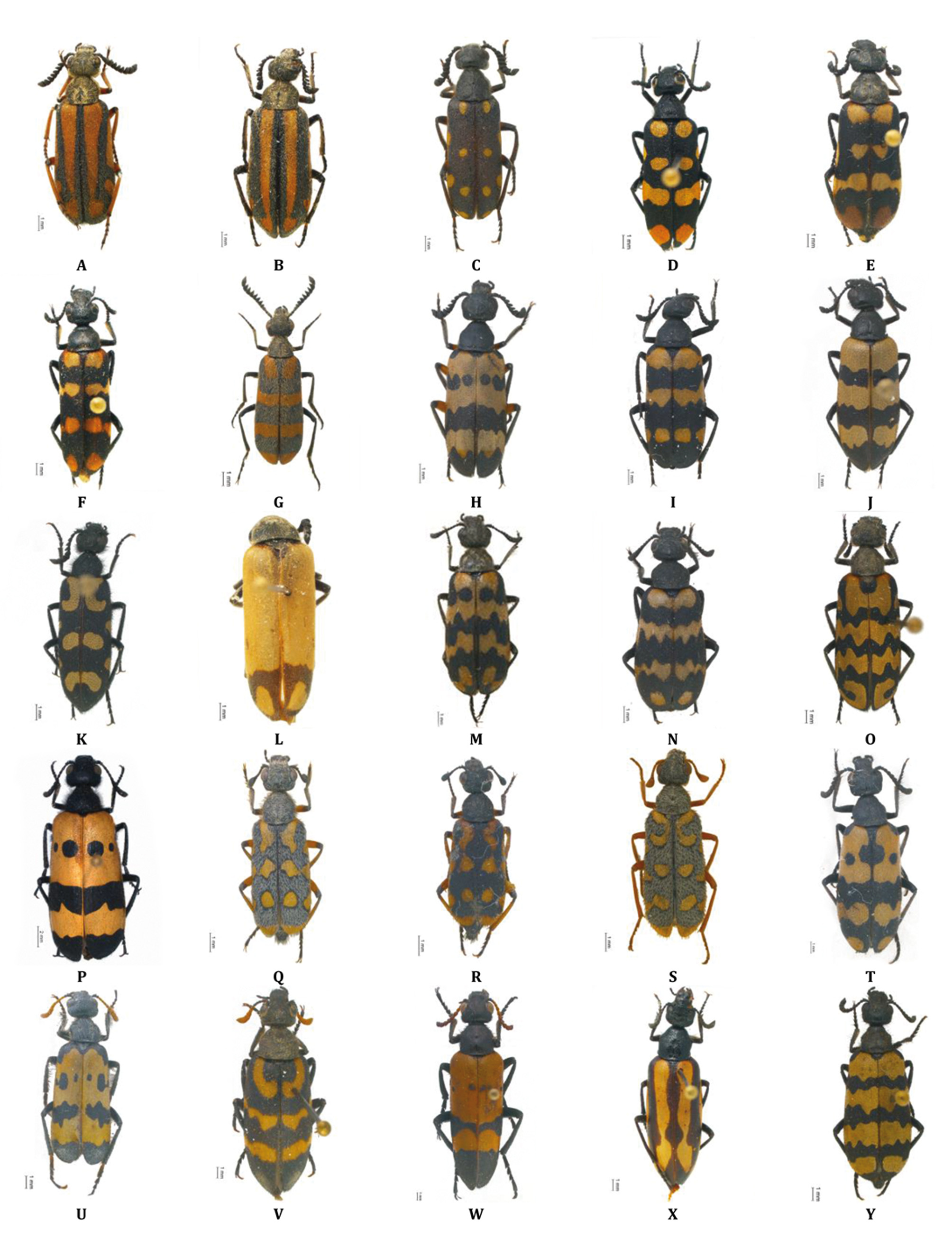
Hycleus dentatus (Olivier, 1811) ( Fig. 3O View FIGURE 3 ) Mylabris dentata Olivier, 1811 Mylabris tortuosa Erichson, 1843 Coryna dentata, Bologna 1978
Distribution. Angola, Congo (new species record for this country: Boma, AMNH), and Namibia . Cited also from Senegal and Sierra Leone, but these western African citations need confirmation.
Material examined and literature records. [Omusati] Ruacana: Ruacana Falls (road C46), 17.4000°S 14.2833°E (CB). Outapi: Mahanene Res. Station GoogleMaps , 17.4500°S 14.8000°E ( SMWN). Okahao: C35, Kamanjab- Ruacana 25 km NW of Kamanjab GoogleMaps , 18.4775°S 14.6977°E (CB); Otjiovasandu, Etosha N.P., 19.2500°S 14.5000°E (SMWN); Kaross, Etosha N.P., 19.3833°S 14.5333°E ( SMWN). [Kunene] Epupa: Hippo Pool on Kunene River GoogleMaps , 20 km W Ruacana , 17.4092°S 14.2185°E (CB); Okakatowo, 17.4500°S 12.7000°E ( SMWN) GoogleMaps ; Okambele, 17.6167°S 14.0500°E (SMWN). Opuwo: Opuwo town , 18.0500°S 13.8333°E (CB) GoogleMaps ; 30 km WNW Orupembe , 18.1167°S 12.3500°E ( SMWN) GoogleMaps ; D3710, near Opuwo, 18.1589°S 13.9173°E (CB); D3710, near Opuwo, 18.2011°S 13.8994°E (CB); Kunene distr., C43, 18.7599°S 13.7489°E (CB); C35, Kamanjab-Ruacana, 18.9027°S 14.3903°E (CB). Sesfontein: Beisebvlakte, Etosha N.P., 19.0167°S 14.0833°E ( SMWN) GoogleMaps ; Kamanjab, D 2650, 19.8087°S 14.5128°E (CB). Kamanjab: C40, 26 km E Kamanjab, 19.6957°S 15.1046°E (CB); Outjo-Kamanjab 95 km N of Outjo GoogleMaps , 19.8040°S 15.3290°E (CB); Otjitambi, 19.8167°S 15.1667°E (SMWN); C39, 25 km E Khorixas, 20.3061°S 15.1867°E (CB). [Oshikoto] Engodi: Okashana Agric GoogleMaps . Experimental Station , 18.2500°S 16.6667°E ( SMWN) GoogleMaps ; 30 km W Oshivelo, 18.4870°S 17.0000°E (CB). Omuthiyagwiipundi: Okashana Experimental Station GoogleMaps , 18.5833°S 16.6500°E (SMWN). Guinas: Tsumeb, Onguma 314, 18.7333°S 17.0500°E (SMWN). [Otjozondjupa] Otjiwarongo: D2430, 25 km N Otjiwarongo, 20.2667°S 16.6167°E (CB); Cleveland 17, 20.4050°S 16.6590°E ( SMWN) GoogleMaps ; Garfield, 20.4450°S 16.0830°E (SMWN); C63, Outjo-Kalkfeld 15 km N of Kalkfeld , 20.7537°S 16.2210°E (CB). Omatako: Waterberg, jct. roads C22-2512, 20.6333°S 17.1500°E (CB); Hamakari S 373, 20.6667°S 17.3833°E ( SMWN) GoogleMaps ; Hamakari S 373, 20.6667°S 17.4000°E (SMWN); Mount Etjo Safari Lodge , 21.0167°S 16.4167°E (CB); 100 km N Okahanjia GoogleMaps , 21.0920°S 16.8280°E (CP); D2414, Etjo-Kalkfeld, Dinosaurus Tracks, 21.1156°S 16.4161°E (CB); D2414, Etjo-Kalkfeld 38 km SE of Kalkfeld GoogleMaps , 21.1288°S 16.3883°E (CB); Okahandja Townlands, 21.6667°S 17.3333°E (SMWN). Okahandja: Ongambeanavita, 21.5800°S 16.5900°E (SMWN); 25 km N of Okahandja , 21.7619°S 16.8743°E (CB); B2, 31 km W Okahandja, 21.9157°S 16.6199°E (CB); D2192, 4 km jct. B2, 21.9490°S 16.5763°E (CB); Okahandja, 21.9833°S 16.9167°E ( Péringuey, 1909; CP; SMWN) GoogleMaps . [Erongo] Dâures: Otjihorongo Reserve, 20.9000°S 15.2000°E ( SMWN) GoogleMaps . Omaruru: Otjikoko-Sud 61, 21.2833°S 16.3667°E (SMWN); C33, 6 km S Omaruru, 21.4824°S 15.9508°E (CB); C33, 3– 9 km S of Omaruru , 21.4948°S 15.9705°E (CB) GoogleMaps ; 20 km SE Omaruru , 21.6250°S 16.1250°E (JP); C33, 30 km jct. B2, 21.6681°S 15.9799°E (CB); C33, 30 GoogleMaps – 20 km N Karibib , 21.6833°S 15.9667°E (CB). Karibib: D1935, 30 km NNW Usakos, 21.7833°S 15.5000°E (CB); C33, 17 km jct. B2, 21.8390°S 15.9233°E (CB); Karibib, 21.9333°S 15.8333°E (CB); B2, Usakos-Karibib, 16 km W Karibib GoogleMaps , 21.9358°S 15.7056°E (CB); B2, 16 km W Karibib, 21.9358°S 15.7056°E (CB); D 1953, 100 m jct.. C32, 21.9552°S 15.8493°E (CB); B2, 8 km W Usakos, 21.9876°S 15.5057°E (CB); D1953, 45 km jct. C32, 22.2963°S 16.0658°E (CB). Arandis: Upper Panner Gorge GoogleMaps , 22.4833°S 15.0167°E (SMWN). [Khomas] Windhoek Rural: D1525, Windhoek-Gobabis,to Bodenhausen, 1 km N from B6, 22.3968°S 17.6600°E (CB); C23, 26 km S Dordabis, 23.0575°S 17.9329°E (CB); C23, 38 km S Dordabis, 23.0715°S 18.0434°E (CB); D1228, 7 km ENE Rehoboth, 23.2833°S 17.2333°E (CB). Windhoek East: Windhuk, 22.5700°S 17.0836°E (CB); Windhoek, 22.5700°S 17.0836°E (JP). [Omaheke] Aminius: Leonardville, Gobabis, 23.5000°S 18.8000°E ( SMWN) GoogleMaps . Steinhausen: 10 km E Witvlei , 25.ii.1977 ( AMNH) . [Hardap] Rehoboth Rural: B1, km 21, 23.4999°S 17.1284°E (CB); Garies Oos 489, 23.9000°S 16.5500°E ( SMWN) GoogleMaps . Gibeon: Harmonie, 24.7167°S 16.3833°E (SMWN). [Karas] Berseba: Helshoogte, 25.6667°S 16.8000°E ( SMWN) GoogleMaps ; C14, 51 km N Bethanien, 26.2919°S 17.0535°E (CB).
Other records: Swakop ( Marseul 1872); Damaraland ( Kaszab 1956); Namib Sand Sea desert ( Seely 2012); Namibia ( Bologna 2000a; Pitzalis et al. 2014).
Remarks. Types of this species, very distinct by its elytral pattern, are lost, but we examined specimens in the Marseul’s collection (MNHN) which have been probably compared with types.
Species greatly isolated in a possible monotypic group. It is well characterized by 11 antennomeres, dense silver setation on the body, but on elytra, mesosternum completely and densely setate, and unique elytral pattern (see Péringuey 1909).
No known copyright restrictions apply. See Agosti, D., Egloff, W., 2009. Taxonomic information exchange and copyright: the Plazi approach. BMC Research Notes 2009, 2:53 for further explanation.
|
Kingdom |
|
|
Phylum |
|
|
Class |
|
|
Order |
|
|
Family |
|
|
Genus |
Hycleus dentatus
| Bologna, Marco A., Amore, Valentina & Pitzalis, Monica 2018 |
Coryna dentata
| Bologna 1978 |
Mylabris tortuosa
| Erichson 1843 |
Mylabris dentata
| Olivier 1811 |