
Homalium planiflorum subsp. roseiflorum Appleq., 2018
|
publication ID |
https://doi.org/ 10.15553/c2018v731a4 |
|
DOI |
https://doi.org/10.5281/zenodo.6309035 |
|
persistent identifier |
https://treatment.plazi.org/id/03CAA927-3A09-FFA1-E757-FD4BFB592CA3 |
|
treatment provided by |
Carolina |
|
scientific name |
Homalium planiflorum subsp. roseiflorum Appleq. |
| status |
subsp. nov. |
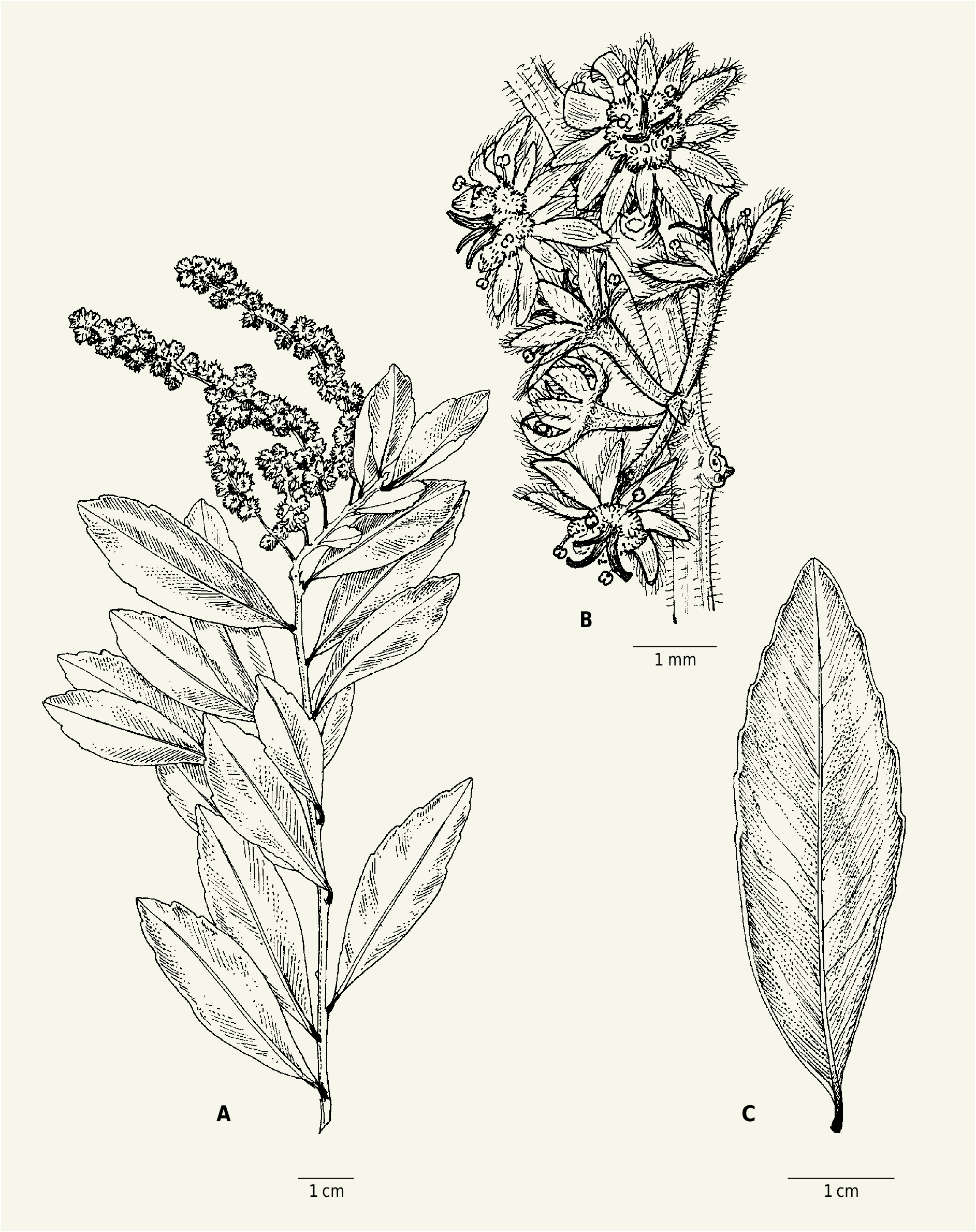
9b. Homalium planiflorum subsp. roseiflorum Appleq. View in CoL , subspec. nova ( Fig. 5 View Fig ).
Holotypus: MADAGASCAR. Prov. Toliara: Anosy , Taolagnaro , Ampasy Nahampoana, forêt littorale d’AmbavaranoMandena , 24°57’S 47°00’E, 5 m, 13.V.2006, fl., Rabenantoandro & Ramisy 1765 ( MO-6450859 ! GoogleMaps ; iso-: G [ G00418622 ] image seen, P [ P00806077 ]!, TAN) .
Homalium planiflorum subsp. roseiflorum Appleq. differs from H. planiflorum (Tul.) Baill. subsp. planiflorum in having inflorescences mostly clustered at twig ends and occasionally paniculate (vs scattered along twigs and almost always racemose), and pink to reddish flowers (vs whitish to greenish or yellowish flowers).
Leaves narrowly elliptical to oblanceolate (aberrantly obovate), 3.5-7.7(-8.7) × 1-2.3(-2.9) cm. Inflorescences racemes, often clustered near twig ends, or occasionally panicles with a few long branches. Flowers pink to reddish, commonly 8-merous, less often 7-merous (9-merous).
Vernacular names. – “Hazofotsy” (Faliniana et al. 2, Randriatafika et al. 319, Réserves Naturelles s.n., Soanary 26); “Zora” (Rabenantoandro et al. 336, Ratovoson 1731); “Zora fotsy” (Ratovoson 1629, 1692).
Uses. – Wood of H. planiflorum subsp. roseiflorum View in CoL is reported to be hard and to be used for construction and to make tool handles (Randriatafika et al. 319, Ratovoson 1629, 1692, 1731, Réserves Naturelles s.n.).
Distribution, ecology and conservation status. – Homalium planiflorum subsp. roseiflorum is confined to coastal forests in southeastern Madagascar. All collections are from a very small portion of Toliara province; most are from the protected areas of Mandena and Sainte Luce, with single collections from four other localities in close proximity (all within ca. 13 km of one of the significant populations). GeoCAT calculates an EOO as c. 320 km 2 and an AOO of 40 km 2. Since there may be six distinct populations, the species cannot be formally assessed as “Vulnerable” [VU D2]. However, all localities are so close together that they could easily be affected by a single event such as a typhoon, and habitat outside the rather limited boundaries of the protected areas is at high threat of anthropogenic damage. A status of “Near Threatened” [NT] is therefore recommended to call attention to this concern.
1 cm 1 cm
Notes. – Homalium planiflorum subsp. roseiflorum is distinguished from the typical subspecies by its flower color (pink to red) and, to some extent, by inflorescence morphology (often clustered near twig apices, occasionally paniculate). Its leaves are on average somewhat narrower and more likely to tend to oblanceolate than those of subsp. planiflorum , and the average number of sepals and petals per flower is slightly greater (more often eight than seven, and rarely nine, whereas seven- and eight-petaled flowers are about equally common in subsp. planiflorum ). However, these latter characters overlap too much to be taxonomically useful.
Paratypi. – MADAGASCAR. Prov. Toliara: Mandena, étude parcelles campement , 24°57’S 47°00’E, 0-10 m, 17.IV.1989, ster., Dumetz et al. 666 ( P) GoogleMaps ; Sainte Luce, 24°47’S 47°10’E, 0-10 m, 20.X.1989, fl., Dumetz et al. 754 ( MO, P) GoogleMaps ; Mandena, 24°57’S 47°00’E, 6.XII.1989, fl. & fr., Dumetz & McPherson 1127 ( MO, P) GoogleMaps ; Mandena, 0-10 m, 24.I.1990, fr., Dumetz 1236 ( MO, P) ; Sainte Luce, 24°46’46’’S 47°10’17’’E, 10 m, 15.XII.2000, fl., Faliniaina et al. 2 ( MO) GoogleMaps ; Sainte Luce, proposed QIT mining conservation area , 24°46’42’’E 47°10’15’’E, 0 m, 13.X.2000, fl., Hoffmann et al. 209 ( MO [2 sheets]) ; Near Mandena beyond QIT camp , 24°57’S 47°00’E, 25 m, 31.X.1989, buds, McPherson & Dumetz 14339 ( P) GoogleMaps ; ibid. loco, 20 m, 4.XI.1989, fl., McPherson 14369 ( MO, P) ; M7 , Taolagnaro , M 7 [Mandena], 24°57’31’’S 47°00’02’’E, 0-10 m, 6.X.2000, fl., Rabenantoandro et al. 336 ( G, MO, P) GoogleMaps ; Sainte Luce, près du campement QMM , 24°46’47’’S 47°10’17’’E, 3 m, 29.X.2003, buds, Rabenantoandro et al. 1522 ( MO, P) GoogleMaps ; Mandena, 24°57’S 47°02’E, 10 m, 13.I.1990, fr., Rabevohitra 2123 ( MO, P) GoogleMaps ; Taolagnaro, à 1 km au N d’Evatra, 24°57’S 47°06’E, 17.I.1990, fl. & fr., Rabevohitra 2153 ( MO, P) GoogleMaps ; Sainte Luce, forêt d’Analavinaky à l’W d’Ambandrika , 24°46’30’’S 47°09’00’’E, 21 m, 24.XI.2009, post-fl., Rakotovao 4737 ( MO) GoogleMaps ; Fkt. Fenoambony, E du village Androangabe , 24°53’S 46°59’E, 58 m, 5.XII.2009, post-fl., Rakotovao et al. 5042 ( MO) GoogleMaps ; Sainte Luce, S5 [forest parcel] , 24°47’S 47°11’E, 2.II.2008, post-fl., Ramison & Rabehevitra 561 ( MO) GoogleMaps ; Sainte Luce, 4-5 km N of Manafiafy along main trail into forest, 24°47’S 47°09’E, 0-10 m, 19.XI.1996, fl., A. Randrianasolo 567 ( G, MO, P) GoogleMaps ; Fkt. Ampasy-Nahampona , Station forestière de Mandena (M3) , 3.X.2001, fl., Randriatafika et al. 319 ( MO) ; Sainte Luce, S 10 , 3 km au N d’Ambandrika, 24°44’39’’S 47°10’45’’E, 50 m, 19.XI.2011, fl., Ratovoson 1629 ( MO) GoogleMaps ; Sainte Luce, S11 , 3.1 km au N d’Ambandrika, 24°44’26’’S 47°10’38’’E, 20 m, 21.XI.2011, fl., Ratovoson 1692 ( MO) GoogleMaps ; Mahatalaky , Belavenoko , S 5 , 1 km E de Belavenoko Forêt, 24°49’51’’S 47°06’49’’E, 20 m, 23.XI.2011, fl., Ratovoson 1731 ( MO) GoogleMaps ; Mandena ( route Nancy ), 6.XII.1949, fl., Réserves Naturelles (Ranjatson) s.n. ( P) ; Sainte Luce, QMM Forestry Station , parcel S9 , 24°46’05’’S 47°10’16’’E, 11 m, 23.I.2006, fl., Rogers et al. 970 ( G, MO) GoogleMaps ; forêt de Vinanibe , près de Fort Dauphin , 10.XII.1961, fl., Service Forestier 20513 ( P [2 sheets]) ; Fkt. Ampasinahampoana , forêt de Mandena , block M15 , 24°57’09’’S 47°00’10’’E, 6.XII.2001, fl., Soanary et al. 26 ( MO) GoogleMaps Intermediate or unidentifiable specimens. – MADAGASCAR. Prov. Toliara: vicin. Fort-Dauphin , 15.XI.1967, fl., Bernardi 11517 ( P) ; Fort-Dauphin, s.d., fl., Cloisel 120 ( P) ; Fort-Dauphin, Ambinanibe , 28.II.1973, fl., Debray 1985 ( P) ; Petriky forest , N of NE corner of Lake Andranany , NW of large dune at end of road , 25°03’S 46°53’E, 0-10 m, 12.IV.1989, ster., Gereau et al. 3365 ( P) GoogleMaps ; Fort Dauphin, VI.1889, fl., Scott Elliot 2835 ( P) .
| G |
Conservatoire et Jardin botaniques de la Ville de Genève |
| P |
Museum National d' Histoire Naturelle, Paris (MNHN) - Vascular Plants |
| TAN |
Parc de Tsimbazaza |
| MO |
Missouri Botanical Garden |
No known copyright restrictions apply. See Agosti, D., Egloff, W., 2009. Taxonomic information exchange and copyright: the Plazi approach. BMC Research Notes 2009, 2:53 for further explanation.
|
Kingdom |
|
|
Phylum |
|
|
Class |
|
|
Order |
|
|
Family |
|
|
Genus |
Homalium planiflorum subsp. roseiflorum Appleq.
| Applequist, Wendy L. 2018 |
H. planiflorum subsp. roseiflorum
| Appleq. A. Flowering 2018 |