
Gulella kenbrowni, Cole & Herbert, 2022
|
publication ID |
https://doi.org/ 10.5852/ejt.2022.813.1729 |
|
publication LSID |
lsid:zoobank.org:pub:687DE2C9-28A4-43E6-A47D-DE2D2839AB60 |
|
DOI |
https://doi.org/10.5281/zenodo.6452991 |
|
persistent identifier |
https://treatment.plazi.org/id/A6355821-8B4F-4C8B-B6E8-9F01ECF2B66A |
|
taxon LSID |
lsid:zoobank.org:act:A6355821-8B4F-4C8B-B6E8-9F01ECF2B66A |
|
treatment provided by |
Felipe |
|
scientific name |
Gulella kenbrowni |
| status |
sp. nov. |
Gulella kenbrowni View in CoL sp. nov.
urn:lsid:zoobank.org:act:A6355821-8B4F-4C8B-B6E8-9F01ECF2B66A
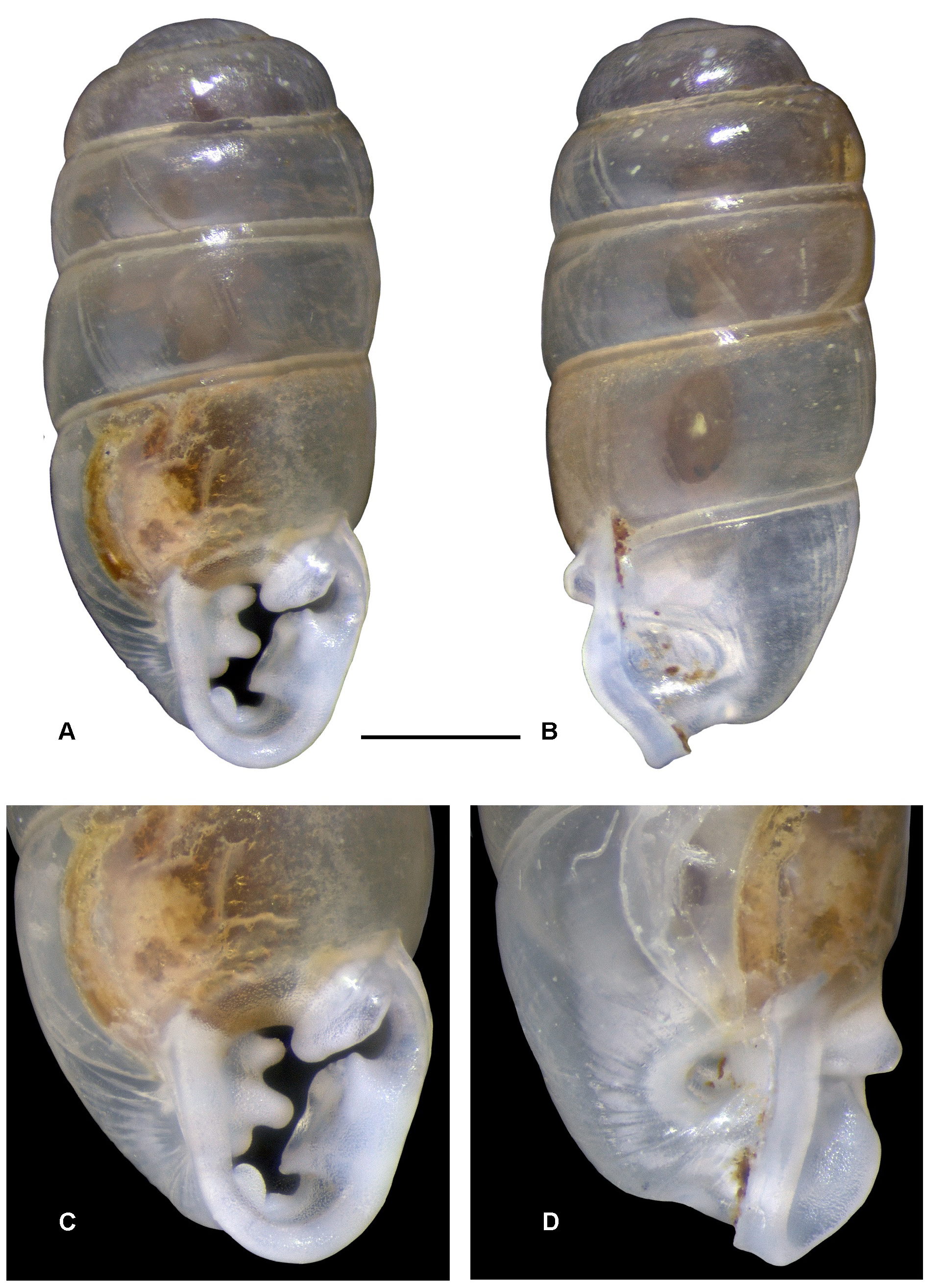
Figs 1A–D View Fig , 2 View Fig
Diagnosis
Shell minute, cylindrical; smooth and glossy; aperture sub-quadrate; apertural dentition seven-fold, including a parietal lamella, a large labral complex extending deeply into aperture with ridge-like upper and lower margins and hollow in centre, a low, inset transverse basal tooth to right of centre, a stronger inset basal tooth to left of centre and a large tricuspid columella lamella with two strong ridge-like teeth, and a smaller tooth below these; umbilicus widely open.
Etymology
Named for Kenneth Brown, long-standing member of the Conchological Society of South Africa, and with a particular interest in Streptaxoidea.
Material examined
Holotype SOUTH AFRICA – Eastern Cape • Umtiza Nature Reserve, Tree Dassie Trail, East side of Buffalo Pass; 33.0144° S, 27.8081° E; 21 Apr. 2006; M. Bursey leg.; NMSA P1678/T4524, prev. ELMD 14909 . GoogleMaps
Paratypes (listed from west to east) SOUTHAFRICA – Eastern Cape • 1spec.;same collection data as for holotype; NMW.Z.2021.011.00004 , prev. ELMD 14909 GoogleMaps • 1 spec.; same collection data as for preceding; 8 Apr. 2002; M. Bursey leg.; NHMUK 20210065 View Materials , prev. ELMD 13854 GoogleMaps • 4 specs.; East London ; 33.00° S, 27.93° E; J. Farquhar collection; ELMD 13413/T 209, prev. NMSA E8144 View Materials GoogleMaps • 2 specs.; same collection data as for preceding; NHMUK 20210066 View Materials , prev. ELMD 13413 GoogleMaps • 2 specs.; Nxaxo Forest , secondary dune forest; 32.5683°S, 28.5416° E; 19 Feb. 2008; M. Cole leg.; ELMD 15770/T 210 GoogleMaps • 1 spec.; same collection data as for preceding; RMNH.MOL.452584 , prev. ELMD 15770 GoogleMaps • 1 spec.; Nxaxo, forest West of river mouth; 32.5945° S, 28.5158° E; 21 Feb. 2008; M. Cole leg.; ELMD 15786/T 211 GoogleMaps • 3 specs.; Ngqara , between Cebe and Mazeppa Bay, riverine forest 300 m upstream of mouth; 32.4902°S, 28.6128° E; 30 Mar. 2004; M. Bursey leg.; ELMD 13718/T 212 GoogleMaps • 9 specs.; Mcelwana, between Cebe and Mazeppa Bay, dune forest on East bank of estuary; 32.4985° S, 28.6044°E; 15 Apr. 2005; M. Bursey leg.; ELMD 15329/T 213 GoogleMaps • 1 spec.; Dwesa Nature Reserve, dune forest West of Kobola estuary; 32.3029°S, 28.8365° E; 1 Oct. 2017; M. Cole leg.; ELMD 18310/T 214 GoogleMaps • 5 specs.; Cwebe Nature Reserve, East side of Mbashe River, vicinity of Mbhanyana Falls; 32.2206° S, 28.9079° E; 4 Feb. 2004; M. Bursey leg.; ELMD 13889/T 215 GoogleMaps • 2 specs.; same collection data as for preceding; NMW.Z.2021.011.00005 , prev. ELMD 13889 GoogleMaps • 2 specs.; Cwebe Nature Reserve, East side of Mbashe River, vicinity of Mbhanyana Falls; 32.2206°S, 28.9079°E; 26 Oct. 2004; M. Bursey leg.; RMNH.MOL.452582 , prev. ELMD 13889. KwaZulu-Natal GoogleMaps • 6 specs.; Mtamvuna Gorge, Lourie Trail , riverine scarp forest, stn 11-08; 31.0563° S, 30.1689°E; 40 m a.s.l.; 13 Apr. 2011; D. Herbert, L. Davis, M. and Cole, R. Daniels leg.; NMSA W7906/T4480 GoogleMaps • 2 specs.; same locality as for preceding; ELMD 18751/T 216, prev. NMSA W7906 View Materials GoogleMaps • 3 specs.; same collection data as for preceding; 27 Dec. 2002; D. Herbert leg.; NMSA W679/T4472 GoogleMaps • 2 specs.; Ngele Forest, mist-belt Podocarpus forest ; 30.54°S, 29.65°E; ± 1350 m a.s.l.; 14 Nov. 1995; D. Herbert and L. Davis leg., in leaf-litter sample; NMSA V5186/T4476 GoogleMaps • 12 specs.; Trafalgar area, Mpenjati Nature Reserve, Yengele Trail , dune forest; 30.9691°S, 30.2820°E; 7 m a.s.l.; 28 Dec. 2002; D. Herbert leg.; NMSA W379/T4474 GoogleMaps • 1 spec.; same collection data as for preceding; ELMD 18752/T 217, prev. NMSA W379 View Materials GoogleMaps • 2 specs.; same collection data as for preceding; NHMUK 20210072 View Materials , prev. NMSA W379 View Materials GoogleMaps • 2 specs.; same collection data as for preceding; NMW.Z.2021.012.00001 , prev. NMSA W379 View Materials GoogleMaps • 2 specs.; same collection data as for preceding; RMNH.MOL.452583 , prev. NMSA W379 View Materials GoogleMaps • 1 spec.; same collection data as for preceding; NMSA W7443/T4475 GoogleMaps • 3 specs.; Umdoni Nature Reserve , coastal forest, 30.39° S, 30.67° E; 28 Oct. 2001; C. Symes leg.; NMSA W857/T4482 GoogleMaps .
Other material (listed from west to east)
SOUTH AFRICA – Eastern Cape • 2 specs.; same collection data as for holotype; ELMD 14909 GoogleMaps • 1 spec.; same collection data as for preceding; 8 Apr. 2002; M. Bursey leg.; ELMD 13854 GoogleMaps • 2 specs.; East London Golf Club , dune forest; 32.9986° S, 27.9395° E; ± 60 m a.s.l.; 3 Sep. 2007; M. Cole leg.; ELMD 15582 GoogleMaps • 3 specs.; Ocean View Farm, Mpetu Hill ; 32.6481° S, 28.0939° E; ± 430 m a.s.l.; 3 Mar. 2005; M. Bursey leg.; ELMD 15308 GoogleMaps KwaZulu-Natal • 1 spec.; Mtamvuna Gorge, Lourie Trail , riverine scarp forest, stn 11-08; 31.0563°S, 30.1689° E; 40 m a.s.l.; 13 Apr. 2011; D. Herbert, L. Davis, M. Cole and R. Daniels leg.; NMSA P1611 View Materials , prev. NMSA W7906 View Materials GoogleMaps • 2 specs.; Trafalgar area, Mpenjati Nature Reserve, Yengele Trail , dune forest; 30.9691°S, 30.2820° E; 7 m a.s.l.; 19 Dec. 1997; K. Cradock leg.; NMSA V6811 View Materials GoogleMaps • 4 specs.; same collection data as for preceding; 28 Dec. 2002; D. Herbert leg.; NMSA P1609 View Materials , prev. NMSA W379 View Materials GoogleMaps .
Description
SHELL ( Fig. 1 View Fig ). Shell minute, cylindrical, length 1.9–2.4mm, width 0.8–1.0 mm, L:W 2.0–2.5 (n = 25); smooth and glossy but with indistinct, microscopic growth lines. Protoconch approx. 0.8 mm in diameter, comprising approx. 2.25 whorls, smooth; junction between protoconch and teleoconch not distinct. Teleoconch comprising approx. 3.5 whorls; first two whorls roundly convex, subsequent ones more weakly convex ( Fig. 1A–B View Fig ). Aperture sub-quadrate, rounded at base, markedly constricted by teeth; peristome thickened and reflected, broadly interrupted in parietal region; dentition seven-fold ( Fig. 1C View Fig ): 1) a strong parietal lamella, outer portion oblique and then curving inward so that the remainder runs into aperture more or less at right angles; outer portion fuses smoothly with outer lip; 2) a large labral slab extending deeply into aperture, with a sharp upper margin beginning with a cusp near lip edge defining lower part of labral sinus and running into aperture more or less parallel to parietal lamella, and a blunt ridge on its lower margin not reaching lip edge; 3) a low, deeply inset transverse basal tooth just to right of centre; 4) a less deeply inset, stronger, in-running, somewhat ridge-like, basal tooth to left of centre; 5–7) a large columella lamella with three teeth, middle and upper ones strong, with a shorter tooth below these at its base; middle tooth largest and ridge-like often curving downwards as it runs into aperture and appearing concave on its lower surface. Labral slab corresponds with a fairly shallow indentation behind outer lip ( Fig. 1B View Fig ). Umbilicus widely open, elongate-oval, with a deep indentation underlying columella lamella; umbilical margin with axial pleats, often irregular and rather indistinct ( Fig. 1D View Fig ). Shell almost transparent when fresh, orange-red or yellowish coloration of dried tissue of animal visible internally.
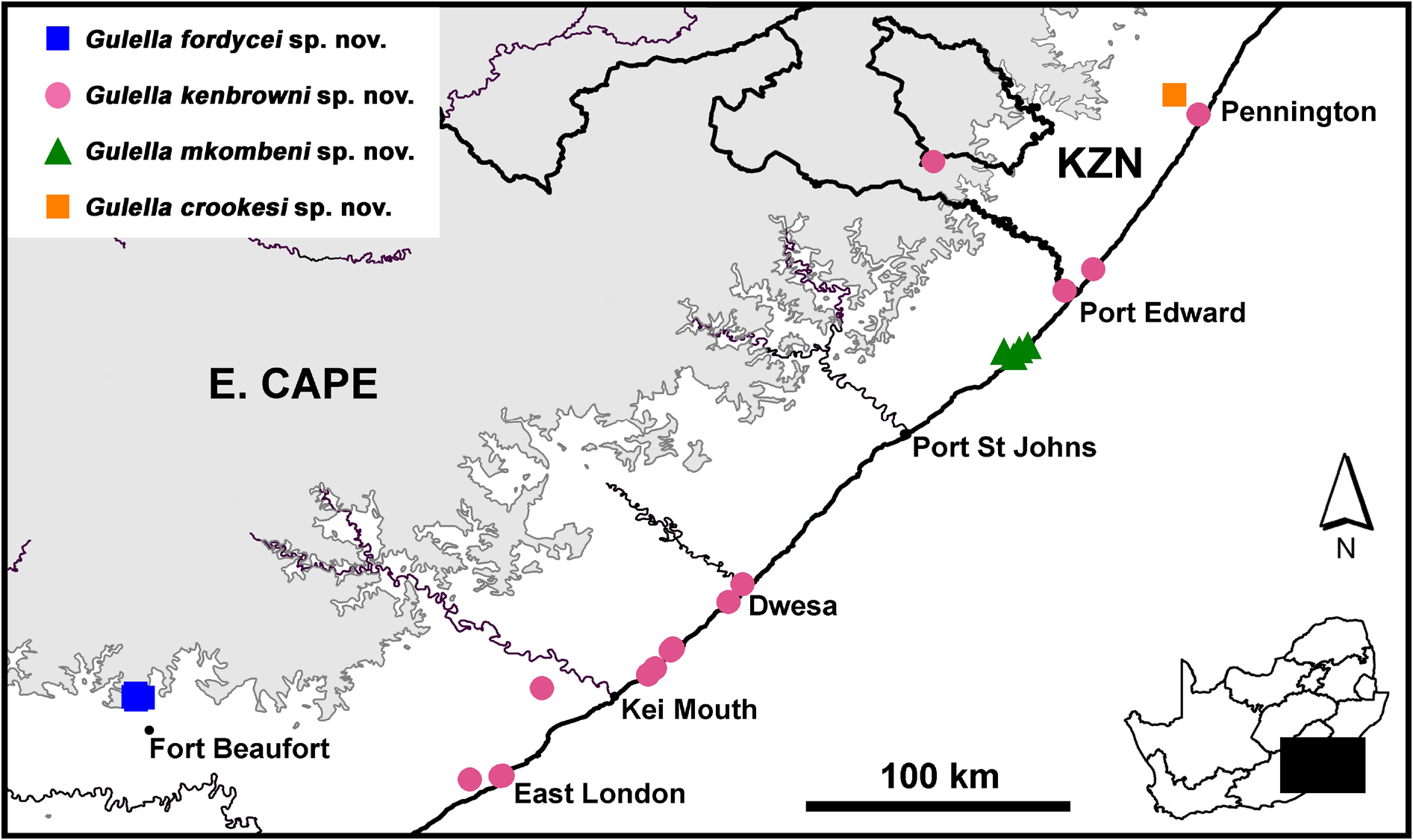
Distribution ( Fig. 2 View Fig )
Recorded on the coast of the Eastern Cape from East London northwards and in southern KwaZulu- Natal, where it is also recorded inland in the Kokstad area (1350 m a.s.l.). The latter locality is somewhat unexpected since the species is usually collected in close proximity to the coast.
Habitat
Coastal forest, including several classification types: Southern Coastal Forest, Scarp Forest, Transkei Dune Forest, Indian Ocean Coastal Belt ( Mucina & Geldenhuys 2006; von Maltitz et al. 2003) and Southern Mistbelt Forest (Ngele near Kokstad) ( Mucina & Geldenhuys 2006); in leaf-litter and under logs.
Remarks
Gulella kenbrowni sp. nov. has been treated as G. sylvia (Melvill & Ponsonby, 1903) ( Herbert & Kilburn 2004) , although it was noted that Transkei and southern KwaZulu-Natal material might turn out to be a separate, unnamed species upon further study. Gulella kenbrowni sp. nov. resembles G. bomvana Cole & Herbert, 2009 , which occupies a small area within the range of G. kenbrowni sp. nov., but the latter is larger, its basal tooth is further to the left of centre, and its umbilicus is widely open. Gulella kenbrowni sp. nov. also closely resembles G. fordycei sp. nov. described below; differences are discussed thereunder. The labral slab resembles that of Gulella tietzae Cole & Herbert, 2009 , but it is smaller than that of both G. bomvana and G. tietzae .
Conservation
Gulella kenbrowni sp. nov. occurs over a relatively wider range than the other species described in this paper and many other South African Streptaxidae ( Herbert & Kilburn 2004; Bursey & Herbert 2004; Cole & Herbert 2009). There are several small nature reserves within its range, but uncontrolled human access and trampling by cattle are commonplace. Forests in this region remain habitats of conservation concern.
| NMSA |
KwaZulu-Natal Museum |
No known copyright restrictions apply. See Agosti, D., Egloff, W., 2009. Taxonomic information exchange and copyright: the Plazi approach. BMC Research Notes 2009, 2:53 for further explanation.
|
Kingdom |
|
|
Phylum |
|
|
Class |
|
|
Order |
|
|
Family |
|
|
Genus |