
Gulella donaikeni, Cole & Herbert, 2022
|
publication ID |
https://doi.org/ 10.5852/ejt.2022.813.1729 |
|
publication LSID |
lsid:zoobank.org:pub:687DE2C9-28A4-43E6-A47D-DE2D2839AB60 |
|
DOI |
https://doi.org/10.5281/zenodo.6452997 |
|
persistent identifier |
https://treatment.plazi.org/id/1AB31B08-9507-4F43-9560-87DAC90A52C5 |
|
taxon LSID |
lsid:zoobank.org:act:1AB31B08-9507-4F43-9560-87DAC90A52C5 |
|
treatment provided by |
Felipe |
|
scientific name |
Gulella donaikeni |
| status |
sp. nov. |
Gulella donaikeni View in CoL sp. nov.
urn:lsid:zoobank.org:act:1AB31B08-9507-4F43-9560-87DAC90A52C5
Figs 5A–D View Fig , 6A–B View Fig
Diagnosis
Shell minute, cylindrical; smooth and glossy; apertural dentition seven-fold, including a parietal lamella with outer portion oblique and then curving inward, the labral lip is thickened with a cusp at upper and lower ends and a large scoop-shaped plate extending deeply into aperture, a low, inset transverse basal tooth to right of centre, an inset basal tooth to left of centre and a large columella lamella with two rounded teeth, the lower large and broad and the upper relatively small; umbilicus widely open.
Etymology
Named for Don W. Aiken (1930–1988), an enthusiastic collector of South African land snails and author of two important publications dealing with South African Streptaxidae ( Aiken 1981, 1995).
Material examined
Holotype SOUTH AFRICA – KwaZulu-Natal • Port Shepstone area, Marble Delta, Simuma Hill , scarp forest ; 30.6679°S, 30.3471°E; 255 m a.s.l.; Dec. 2013; D. Herbert leg.; NMSA W9640/T4521 . GoogleMaps
Paratypes SOUTH AFRICA – KwaZulu-Natal • 1 spec.; Port Shepstone area , Marble Delta, South side of Simuma Hill, woodland/forest, stn S 1; 30.6683° S, 30.3470°E; 237 m a.s.l.; Feb. 2012; J. Harvey leg.; NMSA W8785/T4468 GoogleMaps • 2 specs.; same locality as for preceding; NHMUK 20210073 , prev. NMSA W8785 GoogleMaps • 1 spec.; same collection data as for preceding; RMNH.MOL.452588 , prev. NMSA W8785 GoogleMaps • 1 spec.; same collection data as for preceding, stn S3; 30.6666° S, 30.3447° E; 257 m a.s.l.; NMSA W8788/T4465 GoogleMaps • 2 specs.; same collection data as for preceding, stn S6; 30.6687°S, 30.3466° E; 207 m a.s.l.; Feb. 2012; J. Harvey leg.; NMSA W8787/T4470 GoogleMaps • 1 spec.; same collection data as for preceding; NHMUK 20210074 , prev. NMSA W8787 GoogleMaps • 1 spec.; same collection data as for preceding, stn S2; 30.6672° S, 30.3443° E; 230 m a.s.l.; NMSA W8789/T4469 GoogleMaps • 1 spec.; same collection data as for preceding; NMW.Z.2021.012.00003 , prev. NMSA W8789 GoogleMaps • 1 spec.; same collection data as for preceding; RMNH.MOL.452589 , prev. NMSA W8789 GoogleMaps • 1 spec.; Marble Delta, North side of Mzimkulwana River , base of Simuma Hill , dense riverine thicket/woodland, heavily invaded with Lantana and Chromolaena ; 30.6727° S, 30.3427° E; 72 m a.s.l.; 5 Nov. 2001; D. Herbert leg.; NMSA V9640/T4471 GoogleMaps • 3 specs.; Marble Delta; Hlokohloko Valley , middle section, riverine/scarp forest , stn H1; 30.6608°S, 30.3326°E; 188 m a.s.l.; Feb. 2012; J. Harvey leg.; NMSA W8732/T4464 GoogleMaps • 1 spec.; same collection data as for preceding; NMW.Z.2021.012.00004 , prev. NMSA W8732 GoogleMaps • 2 specs.; same collection data as for preceding, stn H3; 30.6622°S, 30.3386°E; 145 m a.s.l.; NMSA W8767/T4467 GoogleMaps • 1 spec.; same collection data as for preceding; ELMD 18759/T 229, prev. NMSA W8767 GoogleMaps • 1 spec.; Hlokohloko Valley, lower section, riverine/scarp forest , stn H5; 30.6589°S, 30.3426°E; 122 m a.s.l.; Feb. 2012; J. Harvey leg.; NMSA W8768/T4463 GoogleMaps • 1 spec.; Port Shepstone area, Four Man’s Hill , scarp forest , stn S3; 30.6736°S, 30.3360°E; 98 m a.s.l.; Dec. 2013; D. Herbert leg.; NMSA W9596/T4466 GoogleMaps • 1 spec.; same collection data as for preceding, stn S5; 30.6721°S, 30.3348°E; 127 m a.s.l.; NMSA W9601/T4473 . GoogleMaps
Other material
SOUTH AFRICA – KwaZulu-Natal • 4 specs.; Port Shepstone area, Marble Delta, Hlokohloko Valley , lower section, riverine/scarp sorest, stn H4; 30.6609°S, 30.3416°E; 130 m a.s.l.; Feb. 2012; J. Harvey leg.; NMSA W8769 View Materials GoogleMaps • 3 specs.; Simuma area, Hlokohloko Valley , 08-036, scarp forest ; 30.6512°S, 30.3443°E; ca 110 m a.s.l.; 5 May 2008; D. Herbert and L. Davis leg.; NMSA W6279 View Materials GoogleMaps • 2 specs.; Port Shepstone area, Four Man’s Hill , scarp forest , stn S5; 30.6721°S, 30.3348°E; 127 m a.s.l.; Dec. 2013; D. Herbert leg.; NMSA P1608 View Materials , prev. NMSA W9601 View Materials GoogleMaps .
Description
SHELL ( Fig. 5 View Fig ). Shell minute, cylindrical, length 1.8–2.3 mm, width 0.8–0.9mm, L:W 2.2–2.6 (n = 16); smooth and glossy with microscopic growth lines. Protoconch approx. 0.7 mm in diameter, comprising approx. 2.5 whorls, smooth; junction between protoconch and teleoconch not distinct. Teleoconch comprising approx. 3.5 whorls; whorls relatively flat-sided ( Fig. 5A–B View Fig ). Aperture sub-quadrate, rounded at base, markedly constricted by teeth; peristome thickened and reflected, broadly interrupted in parietal region; dentition seven-fold ( Fig. 5C View Fig ): 1) a parietal lamella, outer portion strongly oblique (almost transverse) and then curving inward; 2–3) labral lip thickened, forming a vertical ridge which bears a cusp at its upper and lower ends, each inside aperture edge, the upper cusp defines lower part of labral sinus; beginning just behind thickened labral lip a large, shallow scoop-shaped plate with a sharp ridge around its border extends deeply into aperture beyond level of columella lamella in aperture view; 4) a low, deeply inset transverse basal tooth to right of centre; 5) an inset oblique basal tooth to left of centre; 6–7) a large columella lamella with two well-spaced rounded teeth, the lower one large, broad and sloping outward toward outer lip, the upper one smaller and more deep-set. Labral tooth corresponds with a shallow indentation behind outer lip ( Fig. 5B View Fig ); basal tooth to left of centre corresponds with a narrow external furrow ( Fig. 5D View Fig ). Umbilicus open, relatively wide and deep with a conspicuous pit underlying columella lamella, approx. 0.2 mm across, peri-umbilical region with distinct axial pleats ( Fig. 5D View Fig ). Shell almost transparent when fresh, orange-red coloration of dried tissue of animal visible internally.
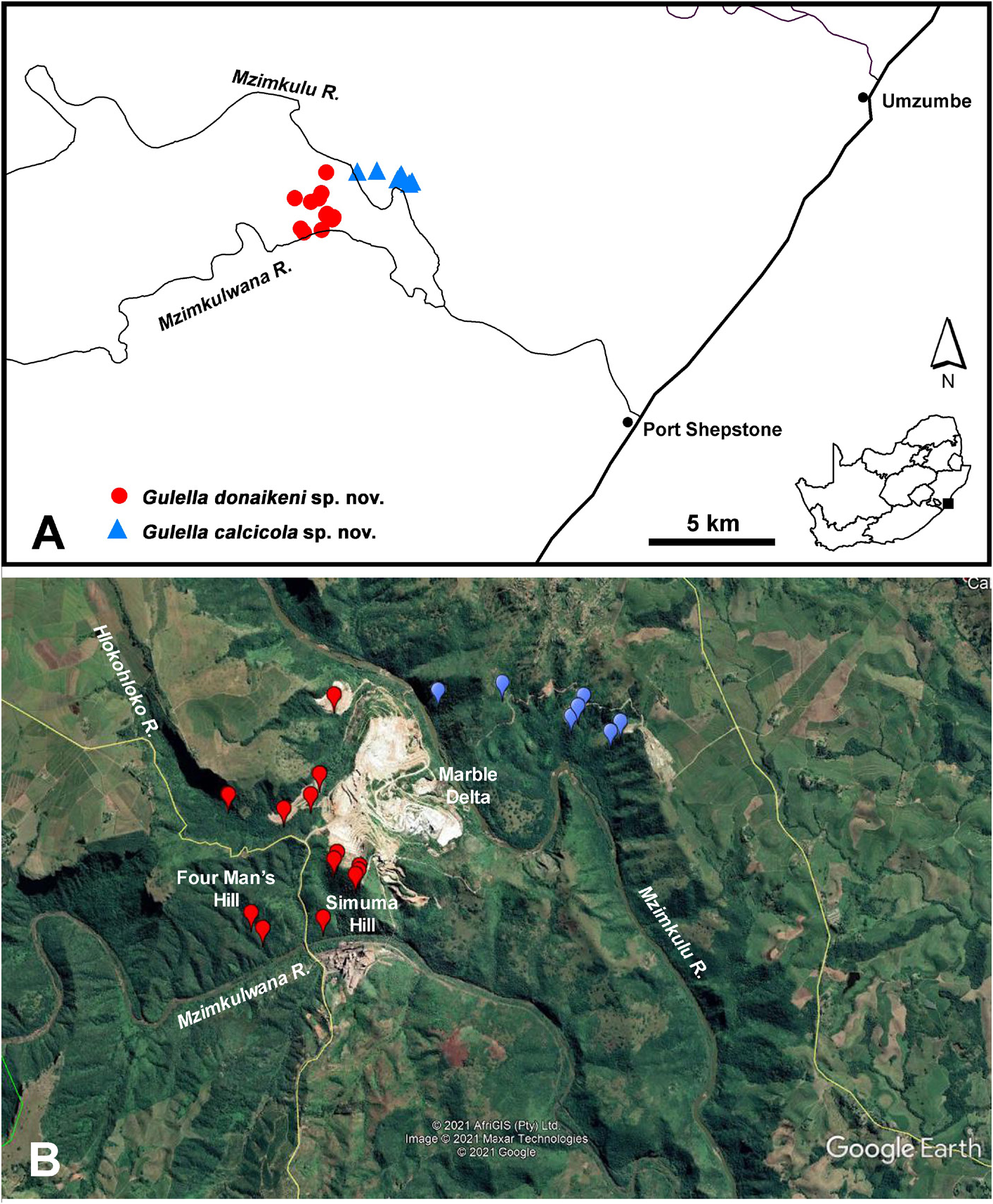
Distribution ( Fig. 6 View Fig )
Known only from an area approx. 16 km NW of Port Shepstone in southern KwaZulu-Natal, mainly from the Marble Delta, and the neighbouring Four Man’s Hill and Hlokohloko Valley. G. donaikeni sp. nov. has only been recorded south of the Mzimkulu River and G. calcicola sp. nov. (see below) only north of the river.
Habitat
Patches of dense valley thicket (Low & Rebelo 1996), also referred to as Eastern Valley Bushveld ( Rutherford et al. 2006) and KwaZulu-Natal Scarp forest ( Mucina et al. 2018b); in leaf-litter and under logs. The indigenous vegetation has been heavily invaded by alien plants, notably Chromolaena odorata (L.) R.M.King ( Asteraceae ), and Lantana camara L. ( Verbenaceae ), both from South and Central America.
Remarks
In terms of its minute size, smooth glossy shell and dentition, Gulella donaikeni sp. nov. resembles G. tietzae , G. kenbrowni sp. nov. and G. mkombeni sp. nov. It is distinguished from G. tietzae by the large rounded lower tooth on the columella lamella and the presence of a low inset basal tooth to
the right of centre. The labral complex extends further into the aperture than that of G. kenbrowni sp. nov., and G. mkombeni sp. nov. and the lower columella tooth is rounded and not ridge-like.
Conservation
Gulella donaikeni sp. nov. has been found in a very small, degraded area and its habitat continues to be threatened by mining. The lower portion of the Hlokohloko Valley has been sacrificed to provide a waste rock dump for the quarry. The species evidently meets the criteria for red-listing as Critically Endangered. Conservation remarks pertaining to Gulella calcicola sp. nov. (see below) also apply to G. donaikeni .

| NMSA |
KwaZulu-Natal Museum |
No known copyright restrictions apply. See Agosti, D., Egloff, W., 2009. Taxonomic information exchange and copyright: the Plazi approach. BMC Research Notes 2009, 2:53 for further explanation.
|
Kingdom |
|
|
Phylum |
|
|
Class |
|
|
Order |
|
|
Family |
|
|
Genus |