
Croton echioides Baill.
|
publication ID |
https://doi.org/ 10.5852/ejt.2022.839.1929 |
|
DOI |
https://doi.org/10.5281/zenodo.7220676 |
|
persistent identifier |
https://treatment.plazi.org/id/76215954-B603-FFC7-52F0-F9B0FAD68BF1 |
|
treatment provided by |
Felipe |
|
scientific name |
Croton echioides Baill. |
| status |
|
Adansonia 4: 34 ( Baillon 1864). – Croton jacobinensis Müll.Arg. View in CoL , Linnaea 34: 91 ( Müller Argoviensis 1865, nom. illeg.). – Type: BRAZIL • Bahia, Jacobina; s.d.; J.S. Blanchet 3718; lectotype: P[P00623146]!, designated by Caruzo et al. 2016; isolectotypes: A[A00257921]!, BR[BR0000008767158]!, C[C 10011166]!, G-DC[G-DC00311429]!, G[G00434487]!, K[K000185989]!, MO[MO1370258]!, NY[NY00246538]!, P[P00623145]!, P[P00623147]!, US [ US 00109547]!, US [ US 1905658]!, W[W0051203]!.
Croton kalkmannii Müll. Arg., Prodromus Systematis Naturalis Regni Vegetabilis 15 (2): 612 ( Müller Argoviensis 1866), syn. nov. – Type: BRAZIL • Ceará; Feb. 1863; Kalkmann 145; lectotype: MEL [ MEL2337251 View Materials ]!, here designated; isolectotypes: G [ G00138454 ]!, MEL [ MEL2337250 View Materials ] ! • ibid.; Kalkmann 146; remaining syntype: MEL [ MEL2337249 View Materials ] !.
Croton macrobothrys var. microbotrys Glaz., Mémoires de la Société Botanique View in CoL de France 59 (3g): 615–616 ( Glaziou 1913, nom. nud.)
Material examined
BRAZIL – Bahia • Abaíra, arredores de Catolés; 13°17′ S, 41°51′ W; 1000–1200 m a.s.l.; 22 Nov. 1991; fl.; V. C. Souza & C. M. Sakuragui H 50256; NY, SPF GoogleMaps • ibid.; 24 Dec. 1991; fl.; R. M. Harley et al. H 50312; NY, MO, SPF GoogleMaps • estrada de engenho entre Catolés e Abaíra; 13°18′ S, 41°49′ W; 1100 m a.s.l.; 31 Jan. 1992; fl. and fr.; J. R. Pirani et al. H 51381; SPF, UB GoogleMaps • Mendonça de Daniel Abreu ; 13°16′ S, 41°49′ W; 1050 m a.s.l.; 24 Feb. 1992; fl. and fr.; B. Stannard et al. H 51568; HUEFS, MBM, NY, RB, SPF GoogleMaps • estrada Catolés-Abaíra, 7 km de Catolés, Mata do Criminoso ; 13°19′ S, 41°48′ W; 1000 m a.s.l.; 26 Feb. 1992; fr.; B. Stannard et al. H 51621; SPF GoogleMaps • Morro do Zabumba, Engenho de Baixo ; 13°18′ S, 41°48′ W; 850 m a.s.l.; 13 Mar. 1992; fr.; B. Stannard et al. H 51937; NY, SPF GoogleMaps • estrada Catolés-Abaíra, ca 5 km de Catolés, Mata do Engenho ; 13°19′ S, 41°49′ W; 1000 m a.s.l.; 24 Nov. 1992; fl.; W. Ganev 1547; HUEFS, HUFU, NY, SP, SPF GoogleMaps • 13°18′ S, 41°49′ W; 930 m a.s.l.; 22 Jan. 1994; fl.; W. Ganev 2856; HUEFS, NY, SPF, UESC GoogleMaps • Serra do Atalho, Complexo Serra da Tromba , 18 Apr. 1994; fr.; E. Melo et al. 992; HUEFS • estrada de chão sentido Cascavel ; 13°19′0″ S, 41°34′24″ W; 767 m a.s.l.; 18 Nov. 2015; fl.; B. R. L. Barbosa et al. 1404; HUEFS GoogleMaps • estrada Abaíra-Catolés; 13°19′ S, 41°47′ W; 17 Dec. 2017; fl.; R. C. Sodré et al. 3314; UFG GoogleMaps • Almadina, rodovia de Almadina para Ibitupã, ca 20 km, Fazenda São Roque, ca 10 km da entrada do ramal; 14°38′27″ S, 39°42′47″ W; 12 Mar. 2005; fr.; P. Fiaschi et al. 2754; CEPEC, SPF, NY GoogleMaps • Barra, Serra do Estreito , 5 Nov. 2009; no fl. or fr.; A. P. Prata et al. 1724; ASE • 10°58′48″ S, 43°33′36″ W; 20 Dec. 2017; fl.; A. S. Soares 404; RB, UB GoogleMaps • Barra do Mendes , estrada do Mendes; 11°52′ S, 42°8′ W; 27 Nov. 1977; fl.; C. A. Miranda 11; RB GoogleMaps • estrada para Canarina, localidade Carretão ; 11°49′33″ S, 42°3′17″ W; 750 m a.s.l.; 15 Dec. 2009; fl. and fr.; E. Melo et al. 7514; ALCB, HUEFS GoogleMaps • ca 21.5 km na estrada de terra para Seabra ; 11°58′25″ S, 42°0′38″ W; 775 m a.s.l.; 16 Dec. 2009; fl.; E. Melo et al. 7571; ALCB, HUEFS GoogleMaps • ca 32 km na estrada de terra para Seabra ; 12°3′7″ S, 42°0′33″ W; 828 m a.s.l.; 16 Dec. 2009; fl.; E. Melo et al. 7591; ALCB, HUEFS GoogleMaps • ibid.; fl. and fr.; E. Melo et al. 7597; ALCB, HUEFS GoogleMaps • estrada para Canarina ; 12°9′3″ S, 42°1′3″ W; 1038 m a.s.l.; 16 Dec. 2009; fl.; E. Melo et al. 7621; ALCB, HUEFS GoogleMaps • ibid.; E. Melo et al. 7634; ALCB, HUEFS GoogleMaps • estrada para Ipupiara ; 11°47′16″ S, 42°11′25″ W; 850 m a.s.l.; 17 Dec. 2009; fl.; E. Melo et al. 7679; ALCB, HUEFS GoogleMaps • Bom Jesus da Lapa, ca 18 km NE de Bom Jesus da Lapa na estrada para Ibotirama ; 13°7′55″ S, 43°18′59″ W; 326 m a.s.l.; 8 Feb. 2000; fr.; L. P. Queiroz et al. 5745; ALCB, CEPEC, HUEFS GoogleMaps • Buritirama; 10°26′23″ S, 43°44′24″ W; 15 Jan. 2018; fl.; O. Neto 974; UB GoogleMaps • Caetité, Caetité / Bom Jesus da Lapa , ca 10 km de Caetité; 13°58′31″ S, 42°32′54″ W; 950 m a.s.l.; 6 Dec. 1999; fl.; E. Melo & F. França 3222; HUEFS GoogleMaps • Região de Brejinho das Ametistas, Área da Bahia Mineração ; 14°19′24″ S, 42°33′25″ W; 980 m a.s.l.; Aug. 2008; fr.; M. S. Mendes et al. 371; BHCB, RON GoogleMaps • Cafarnaum, Propriedade do Sr. Cícero Pereira Lima , 14 Jan. 2012; fl.; J. G. Carvalho-Sobrinho et al. 3237; HUEFS • Campo Formoso; 10°28′ S, 41°14′ W; 29 Apr. 1981; fl.; R. P. Orlandi 377; HUEFS, RB GoogleMaps • Casa Nova, margem do lago do Sobradinho ; 9°33′43″ S, 41°46′6″ W; 415 m a.s.l.; 29 Feb. 2008; fl.; C. Correia et al. 424; HST, HUEFS, UEC GoogleMaps • Correntina, rio Correntina ; 17 Mar. 1995; fl. and fr.; G. Hatschbach et al. 62009; MBM • Delfino, estrada Delfino – Mimoso de Minas , 20 km de Delfino; 10°29′31″ S, 41°20′35″ W; 826 m a.s.l.; 7 Mar. 1997; fr.; P. Gasson et al. PCD6118; ALCB, CEPEC, HUEFS, SPF GoogleMaps • Formosa do Rio Preto , Estação; 10°58′ S, 44°57′ W; 24 Feb. 2005; fr.; M. L. Guedes & A. B. Xavier 11631; ALCB, CEPEC GoogleMaps • Ibiquera, Gruta da Lapinha ; 12°27′51″ S, 40°58′47″ W; 610–710 m a.s.l.; 1 May 2004; fr.; F. França et al. 4960; HUEFS, HUESB GoogleMaps • Igaporã, ca 3 km após Igaporã em direção a Caetité ; 13°48′1.5″ S, 42°39′30″ W; 1010 m a.s.l.; 15 Dec. 2017; fl.; R. C. Sodré et al. 3284; UFG GoogleMaps • Itaetê, estrada para Itaetê, ca 8.7 km do entroncamento com a estrada Mucugê – Andaraí ; 12°55′40″ S, 41°9′52″ W; 440–460 m a.s.l.; 13 Jul. 2003; fl.; F. França et al. 4786; HUEFS GoogleMaps • Licínio de Almeida, Rodovia Caculé / Licínio de Almeida , 38.3 km; 14°38′29″ S, 42°27′41″ W; 850 m a.s.l.; 30 Mar. 2001; fl. and fr.; J. G. Jardim et al. 3231; ALCB, HUEFS, SP GoogleMaps • estrada para Urandi, 7 km de Licínio de Almeida ; 14°44′43″ S, 42°31′2″ W; 750 m a.s.l.; 9 Dec. 2009; fl.; E. Melo et al. 7369; ALCB, HUEFS GoogleMaps • Serra Geral, Mata do Xaxá ; 14°39′6″ S, 42°32′48″ W; 930 m a.s.l.; 22 Jan. 2013; fl.; F. Hurbath 452; ALCB, HUEFS, MBM GoogleMaps • Serra Geral, Saco da Onça, Trilha Fazenda Serrana ; 14°43′53″ S, 42°34′10″ W; 1103 m a.s.l.; 5 Apr. 2013; fr.; F. Hurbath et al. 507; ALCB GoogleMaps • Riacho Fundo ; 14°35′28″ S, 42°32′18″ W; 840 m a.s.l.; 5 Nov. 2013; fl.; F. Hurbath et al. 600; ALCB GoogleMaps • Morro do Chapéu, entre 25 e 26 km de Morro do Chapéu, estrada vicinal próximo à estrada do feijão, próximo ao Ventura ; 11°39′7″ S, 40°57′42″ W; 765–800 m a.s.l.; 18 Nov. 1989; fl.; E. Melo et al. 3188; HUEFS GoogleMaps • Parque Estadual de Morro do Chapéu ; 11°20′43″ S, 41°18′56″ W; 1000 m a.s.l.; 2 Feb. 2008; fl.; F. B. L. Silva & F. França 103; HUEFS GoogleMaps • Buraco do Possidônio ; 11°38′47″ S, 41°16′11″ W; 960 m a.s.l.; 17 Apr. 2008; fl. and fr.; E. Melo et al. 5511; HUEFS GoogleMaps • Buraco da Duda ou Buracão ; 19 Apr. 2008; fr.; E. Melo et al. 5656; HUEFS • divisa com o município de Várzea Nova, Serra da Babilônia, Fazenda Bom Jesus, futura área de implantação do Parque Eólico da Serra da Babilônia ; 11°5′4″ S, 41°18′51″ W; 966 m a.s.l.; 14 Apr. 2016; fl.; L. J. T. Cardoso et al. 1613; RB GoogleMaps • Mucugê, Fazenda Pedra Grande, estrada para Boninal ; 13°0′20″ S, 41°33′48″ W; 990 m a.s.l.; 17 Feb. 1997; fr.; B. Stannard et al. PCD 5813; ALCB, SPF GoogleMaps • Palmeiras, caminho para Conceição dos Gatos; 12°31′59″ S, 41°33′11″ W; 21 Mar. 2003; fr.; E. Melo et al. 3564; HUEFS GoogleMaps • caminho para Serra Preta; 12°31′55″ S, 41°35′14″ W; 28 Mar. 2003; fr.; E. Melo et al. 3633; HUEFS GoogleMaps • ibid.; 12°26′48″ S, 41°36′6″ W; 697 m a.s.l.; 25 Mar. 2010; fl.; S. P. S. Neves 329; HUEFS GoogleMaps • ibid.; fl. and fr.; S. P. S. Neves 330; HUEFS GoogleMaps • Piatã , estrada de terra para a mineração; 13°6′45″ S, 41°41′56″ W; 1112 m a.s.l.; 18 Apr. 2014; fr.; E. Melo et al. 12574; HUEFS GoogleMaps • Ruy Barbosa, Serra do Orobó , trilha para o pátio das orquídeas; 12°18′9″ S, 40°29′15″ W; 521 m a.s.l.; 19 Dec. 2004; fl.; L. P. Queiroz et al. 9961; HUEFS GoogleMaps • Seabra, Serra da Água de Rega, ca 28 km N of Seabra road to Água de Rega ; ca 1000 m a.s.l.; 27 Feb. 1971; fl. and fr.; H. S. Irwin et al. 31178; RB • Senhor do Bonfim, Serra de Santana ; 7 Feb. 2003; fl.; V. J. Santos et al. 266; HUEFS, HUNEB • Tucano, Fazenda Boqueirão ; 12°1′33″ S, 38°38′22″ W; 258 m a.s.l.; 5 Jan. 2006; fl.; D. Cardoso 929; HUEFS, SPF GoogleMaps • Wanderley; 11°42′0″ S, 43°44′24″ W; 24 Jan. 2018; fl.; T. M. Moraes 1402; RB GoogleMaps . – Ceará • Aiuaba; 6°39′36″ S, 40°40′48″ W; 8 Apr. 2014; fl.; W. Batista 353; EAC GoogleMaps • Caucaia ; 11 Mar. 2007; fl.; A. S. F. Castro 1921; EAC • Crateús, RPPN Serra das Almas , 6 Apr. 2001; fr.; M. S. Sobrinho & M. M. A. Bruno 36; EAC • ibid.; M. S. Sobrinho & M. M. A. Bruno 40; EAC, PEUFR • ibid.; 16 Feb. 2002; fl.; F. S. Araújo & L. C. Girão 1316; HUEFS • ibid.; 5°8.166′ S, 40°54.545′ W; 25 Feb. 2002; fl. and fr.; F. S. Araújo 1453; HUEFS GoogleMaps • 20 May 2002; fr.; F. S. Araújo & J. R. Lima 1454; EAC • ibid.; 25 May 2005; fr.; J. R. Lima 81; EAC • Itarema, margem da rodovia para Acaraú ; 21 Apr. 2003; fl.; A. S. F. Castro s.n.; EAC [32597] • Novo Oriente, Planalto de Ibiapaba, Baixa Fria ; 16 Feb. 1991; fr.; F. S. Araújo s.n.; EAC [19451] • São Gonçalo do Amarante, Varjota / Pecém ; 13 Mar. 2011; fl. and fr.; A. S. F. Castro 2454; EAC • Tianguá ; 3°48′ S, 41°4′ W; 550 m a.s.l.; 15 Mar. 1978; fl.; O. A. Salgado 39; RB GoogleMaps • Chapada da Ibiapaba ; 23 Mar. 1979; fl. and fr.; A. Fernandes & F. J. A. Matos s.n.; EAC [5729], UFRN [2348] • ibid.; 16 Feb. 1981; fl.; A. Fernandes & F. J. A. Matos s.n.; EAC [9696] • Ubajara, Planalto de Ibiapaba, Sul do Distrito de Jaburuna ; 21 Feb. 1995; fl.; F. S. Araújo 1119; EAC • ibid.; F. S. Araújo 1120; EAC, UFRN • ibid.; 27 Jan. 1996; fl.; F. S. Araújo 1171; EAC • ibid.; F. S. Araújo s.n.; EAC [23595] . – Espírito Santo • São Roque do Canaã, Pedra do Pionte (São Bento), propriedade do Pionte ; 750 m a.s.l.; 28 Feb. 2004; fl. and fr.; A. P. Fontana et al. 762; MBM . – Minas Gerais • Dom Joaquim, São Domingos, près de Conceição, dans le bois; Nov. or Dec.; fl.; A. F. M. Glaziou 13180; P • Montezuma, ca 23 km NE da cidade, em direção a Montugaba ( BA); 15°3′28″ S, 42°22′32″ W; 900–1000 m a.s.l.; 14 Mar. 1994; fl. and fr.; V. C. Souza et al. 5495; ESA, SPF GoogleMaps • Ninheira , sudoeste de Ninheira; 17°18′45″ S, 41°34′45″ W; 776 m a.s.l.; 13 Jan. 2014; fl.; D. M. Neves 1613; HUEFS, RB GoogleMaps • without further locality; s.d.; fl.; A. F. M. Glaziou 11513; P. – Paraíba • Cajazeiras, Engenheiro Ávidos, Serra de Santa Catarina ; 11 May 2008; fr.; P. C. Gadelha Neto 2238; HUEFS, JPB • São José de Piranhas, topo da serra a direita da Barragem de Engenheiro Ávidos, ca de 2 km a SE da localidade Engenheiro Ávidos ; 6°59′17.55″ S, 38°26′47.43″ W; 592 m a.s.l.; 15 Jan. 2015; fl.; J. L. Costa-Lima & L. S. Lima 2023; HUEFS GoogleMaps . – Pernambuco • Exu, BR-122 sentido Crato / Exu , depois da divisa CE/ PE; 7°17′52″ S, 39°32′53″ W; 927 m a.s.l.; 13 Feb. 2007; fl.; D. S. Carneiro-Torres et al. 874; HUEFS, INPA GoogleMaps • Ipubi, Serrolândia, Chapada do Araripe , 3 km Serra Branca; 15 Feb. 1984; fl.; G. Fotius 3761; HUEFS, IPA • Moreilândia , Sítio dos Moreiras; 22 Feb. 1994; fl. and fr.; M. Andrade-Neto s.n.; EAC [20390], HUEFS [111103] • Ponta da Serra ; 4 Mar. 1995; fl.; E. Silveira s.n.; EAC [21992], HUEFS [111106] • ibid.; 11 Mar. 1997; fl.; F. S. Cavalcanti & E. Silveira s.n.; EAC [24710] • Zé de Belina ; 10 May 2000; fr.; F. S. Cavalcanti 763; EAC • Serra do Catolé , Refúgio das Abelhas Professor Paulo Nogueira Neto; 7.2751° S, 39.28132° W; 880 m a.s.l.; 8 Mar. 2015; fl.; V. M. Mascena C88 ; EAC GoogleMaps • Tacaratu ; 21 Jun. 2013; fl. and fr.; P. Bohrer s.n.; MBM [394421] . – Piauí • Canto do Buriti, Fazenda Itaueira ; 500 m a.s.l.; 9 Jan. 1995; fl.; I. Pinto & E.Alves s.n.; EAC [22098] • ibid.; I. Pinto & E. Alves s.n.; EAC [22114], HUEFS [111108] • Caracol , área do entorno dos cálices rochosos; 9°13′15″ S, 43°28′56″ W; 681 m a.s.l.; 26 Feb. 2011; fr.; E. Melo 9251; HUEFS GoogleMaps • Cocal, Jacarandá ; 3°32′44.3″ S, 41°3′54.6″ W; 340 m a.s.l.; 22 Feb. 2003; fl.; E. M. F. Chaves et al. 125; TEPB GoogleMaps • ibid.; 3°32′43″ S, 41°3′51″ W; 340 m a.s.l.; 18 Feb. 2003; fr.; E. M. F. Chaves & E. M. Sérvio Júnior 346; HUEFS GoogleMaps • Eliseu Martins; 7°55′12″ S, 43°33′36″ W; 6 Aug. 2017; no fl. or fr.; M. S. Gomes 241; UB GoogleMaps • Padre Marcos, Serra Velha, km 2 da vicinal para Alagoinha ; 420 m a.s.l.; 17 Jun. 1993; no fl. or fr.; M. E. Alencar & A. J. Castro s.n.; EAC [19687] • ibid.; 24 Jan. 1994; fl.; M. E. Alencar s.n.; EAC [20717] • ibid.; 10 Mar. 1994; no fl. or fr.; M. E. Alencar s.n.; EAC [20718] • Pio IX, Cova Donga ; 11 Feb. 1982; fl.; M. A. Figueiredo s.n.; EAC [11105] • São João do Piauí, BR-420, São Raimundo Nonato sentido São João do Piauí ; 8°28′57S, 42°18′17″ W; 354 m a.s.l.; 6 Feb. 2007; fl.; D. S. Carneiro-Torres et al. 797; HUESB, INPA, HUEFS GoogleMaps • São Raimundo Nonato, Chapada da Serra Branca ; 7 Feb. 1984; fl.; L. Emperaire 2420; P, RB • without municipality, Serra Branca ; Jan. 1907; fl.; E. Ule 7454; L . – Rio de Janeiro • Entre Rio Bonito et Araruama; Oct.; fl.; A. Glaziou 10039; P .
Description
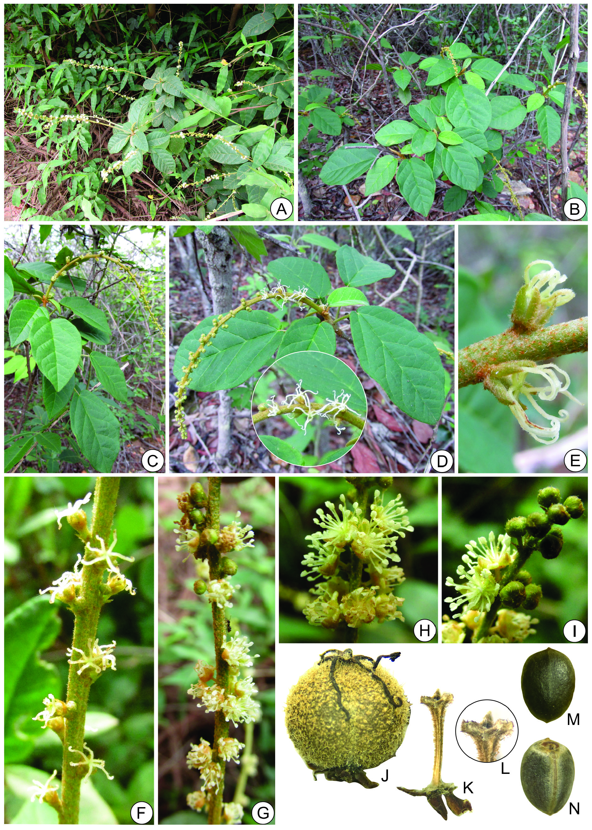
Subshrubs or shrubs, 0.6–2(–3) m tall, erect, usually few-branched with tender, cylindric, straight, smooth (not striate) branches ramifying in di- or trichotomies, sometimes with galls throughout plant; latex abundant, orange or reddish; odoriferous (but not sweetish); whitish or ferrugineous indumentum of stellate-rotate, stellate-lepidote or stellate-porrect trichomes, all with (5–)8–18 lateral rays in singleplane whorl, each ray 0.2–0.6 mm long, free or united up to 10–30% of their length, central ray 0.1– 0.3(–0.5) mm long, stipe 0.1–0.2 mm long. Leaves alternate, or sometimes subopposite or subwhorled near the inflorescences, leaf blades as long as petioles or up to 3 times as long as petioles; stipules 1–3.5 × 0.45–0.6 mm, triangular or lanceolate, without conspicuous glands or with 2 very short globose glands, with hirtellous or glabrescent indumentum of simples trichomes ventrally and dense to sparse indumentum of stellate-porrect trichomes dorsally; petioles (1.8–) 3–8.1 cm long; leaf blades 4.3–13.6 × 2.7–8.2 cm, ovate, elliptic, largely ovate, largely or narrowly elliptic, oblong or lanceolate, membranaceous, base slightly cordate or cordate, less commonly rounded, truncate or obtuse, with 2(3) stipitate-patelliform, cylindric or obconic nectary glands 0.3–0.7 mm diam., stipe 0.5–1.4 mm long, with stellate trichomes, facing abaxial surface; apex acute, obtuse, acuminate, mucronate or apiculate; margin entire with globose sessile glands; venation brochidodromous with 6–10 pairs of secondary veins slightly prominent on both surfaces; discolorous, adaxial surface dark green, glabrous or with sparse indumentum of simple, 2–4-radiate trichomes and sessile stellate-porrect (6–10 lateral rays) trichomes, lateral rays 0.2–0.6 mm long, porrect ray 0.2–0.8 mm long, abaxial surface light green or whitish with shortly tomentose, pubescent or glabrescent indumentum of stellate-porrect or stellate-rotate trichomes, sometimes multiradiate, all with 8–16 lateral rays usually in single-plane whorl, or two-plane whorls in multiradiate trichomes, lateral rays 0.4–1.2 mm long, central ray 0.05–0.8 mm long, stipe 0.1–0.3 mm long. Thyrses 10.4–34.6 cm long, peduncles 1.5–4.5 cm long, terminal, bisexual with 2–18 solitary pistillate flowers sparsely distributed on ⅛–½ of inflorescence axis and staminate cymules with 3–6 flowers, less commonly with bisexual cymules in median portion of rachis, or thyrses unisexual staminate; staminate flower bracts 0.7–1.2 × 0.4– 0.7 mm, triangular or ovate, margin entire, sometimes with 2 ovoid sessile glands (colleters) at base, with pubescent, hirtellous or glabrescent indumentum of simple trichomes ventrally and hirtellous indumentum of stellate-porrect trichomes dorsally, mainly on margin, 2 or more staminate flower bracteoles per cymule 0.5–0.6 × 0.2–0.3 mm, lanceolate or triangular, with glands and indumentum similar to those of bracts; pistillate flower bracts 0.9–1.1 × 0.7–1 mm, triangular or largely ovate, margin entire, apex acute or acuminate, with two ovoid or subglobose sessile glands (colleters) at base and one at apex, with glabrescent or hirsute-tomentose indumentum of stipitate stellate-porrect or 4-radiate trichomes on both surfaces, 2 pistillate flower bracteoles 0.2–0.6 × 0.15–0.3 mm, triangular, with glands and indumentum similar to those of bracts. Staminate flowers 3.5–6.5(–8) mm long; pedicels 0.8–3(–5.7) mm long, glabrous, glabrescent, or sometimes pubescent; calyces 5-partite, yellow-orange or slightly reddish with hyaline indumentum, lobes 1.6–2.1 × 0.9–1.3 mm, ovate, united in ⅙–⅕ of length, apex obtuse, dorsal surface with densely to sparsely pubescent or hirtellous indumentum of stellate-porrect sessile trichomes, villous at apex, glabrous internally; petals 5, 1.9–3 × 0.75–0.9 mm, obovate or oboval-oblanceolate, apex obtuse, truncate or rounded, villous basally along margins at ¼ of length and shortly villous at apex; stamens 16–19, 2.3–3.8 mm long, filaments 1.6–3 mm long, glabrous, anthers 0.6–0.8 × 0.4–0.5 mm, ellipsoid or oblongoid; nectary disks 5-segmented, segments transversely oblong or suborbicular, orange, receptacle villous. Pistillate flowers 3–5 mm long, sessile or pedicels 0.1–1(–1.2) mm long, tomentose; sepals 5(6), 1.3–3 × 0.6–1.3 mm, subequal or strongly unequal, ovate, narrowly triangular, oval-oblong or oval-lanceolate, apex acute, margin entire, without glands, dorsally with sparsely to densely pubescent or tomentose indumentum of stellate-porrect trichomes, margin with hirsute indumentum of simple trichomes and ventrally with glabrescent, pubescent or hirtellous indumentum of simple and fasciculate trichomes; petals globose ca 0.2 mm diam. or laminar 0.6–1.3 × 0.25–0.35(–0.4) mm, lanceolate, glabrous or pubescent; ovary 0.8–1.1 × 0.9–1.6 mm, with subglobose, hirtellous or tomentose indumentum of stellate-porrect shortly stipitate trichomes; styles 3, (2.8–) 4–5.5 mm long, united along lower ⅒ of their length, then branching into 6 terminal tips, externally with hirsute, hirtellous or pubescent indumentum of stellate-porrect or simple trichomes along less than ½ of their length; nectary disks 5-segmented, segments transversely oblong, yellowish. Capsules 4.8–5.5 × 5.5–6 mm, compressed-globose, greenish, pedicels 0.5–1.5 mm long, columella with three flattened or slightly ascending tips; seeds 4.2–4.8 × 3.1–3.5 mm, largely ellipsoid, grayish, smooth surface, slightly foveolate, caruncle hat-shaped 1–2 mm large.
Distribution, habitat and phenology
Croton echioides has been cited by Carneiro-Torres (2009), Silva et al. (2010) and Caruzo et al. (2020) as a species endemic to Brazil distributed in areas of Caatinga and Caatinga-Cerrado transition in the states of Alagoas, Bahia, Ceará, Minas Gerais, Paraíba, Pernambuco, Piauí and Rio Grande do Norte. We confirm occurrence of the species in the states mentioned above, except for Alagoas and Rio Grande do Norte, and provid the first record for the states of Espírito Santo and Rio de Janeiro. This species was found in seasonal dry forest, humid forest, caatinga, in transition areas between caatinga and cerrado, ʻcarrascoʼ or ʻtabuleiro litorâneoʼ growing preferentially on sandy soils, sometimes with outcrops of quartzite, and stony or sandy-clay soils between 30 and 1200 meters a.s.l. It was usually found with flowers from November to April, and with fruits from December to June.
Vernacular names
ʻVelameʼ (Ceará), ʻVelame-da-serraʼ (Pernambuco), ʻVelame-brancoʼ (Piauí).
Preliminary conservation status
Croton echioides has an Extent of Occurrence estimated to be 910 000 km 2 comprising at least 80 subpopulations and has an estimated Area of Occupancy of 4544 km 2 (based on an 8 km 2 cell size) and is therefore provisionally assessed as Least Concern. However, it is worth noting that only three of these known subpopulations occur within protected areas (Experimental Station of the IPA, Serra Talhada, Pernambuco; RPPN Serra das Almas, Cratéus, Ceará; and Morro do Chapéu State Park, Bahia), all the others are in non-protected areas, which may have implications for the conservation of the species in the future.
Leaf anatomy notes
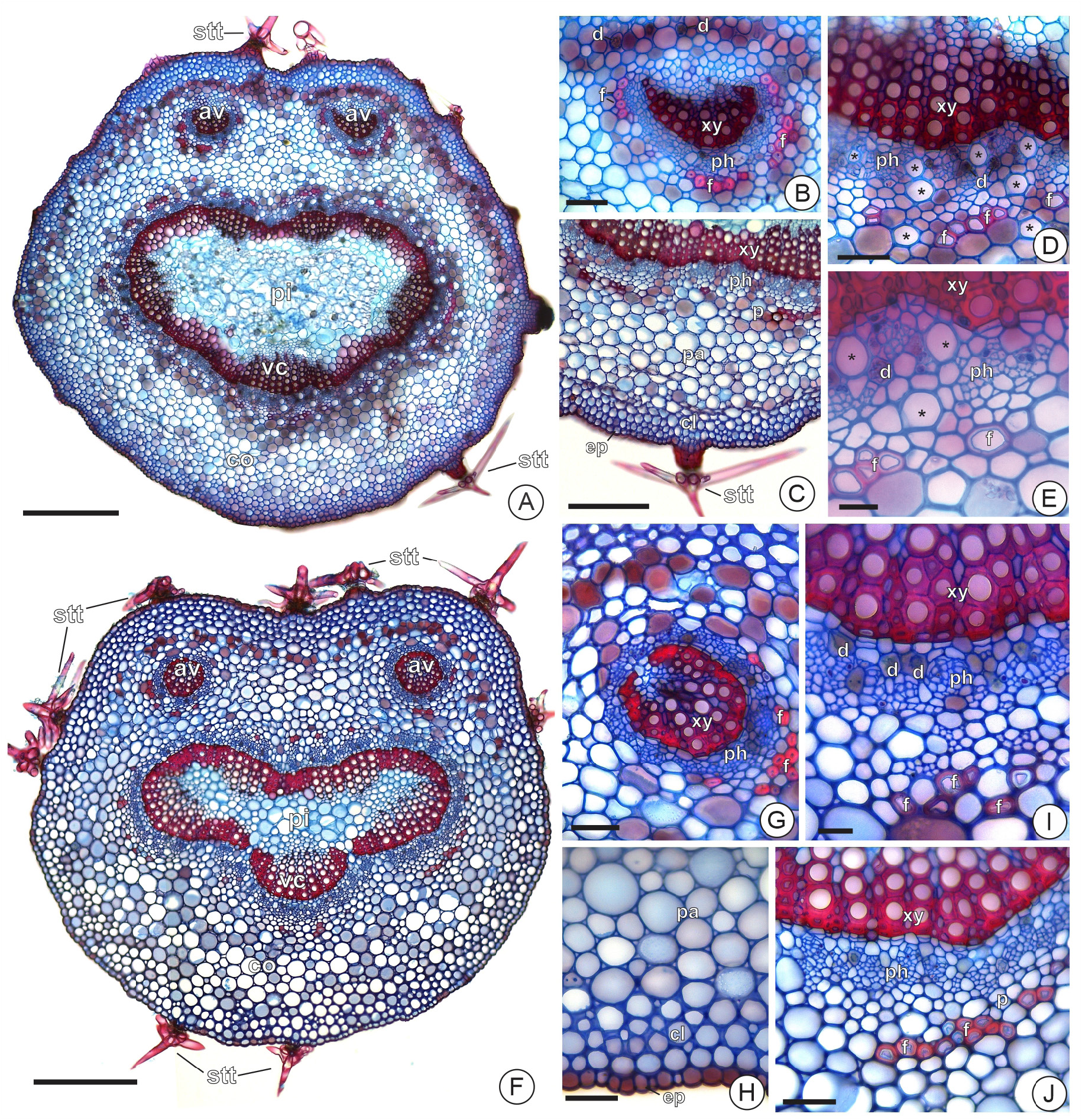
In general, the anatomy of the leaf blades and petiole of Croton echioides and C. sertanejus sp. nov. is relatively similar. Both species have hipostomatic leaves, with stomata on the same level as the other cells of the epidermis, which is unistratified and composed of cells of varying sizes, rectangular or rounded, and has a thin cuticle. The mesophyll in both species is dorsoventral, with a layer of palisade parenchyma and another layer of spongy parenchyma, both with druses ( Fig. 6 F, H, L View Fig ). The leaf margins have rounded outlines and the mesophyll and epidermis are not differentiated from the rest ( Fig. 6I, M View Fig ). The vascular bundles are collateral, surrounded by a conspicuous parenchyma sheath in the smaller vascular bundles and with annular ( Fig. 6 E View Fig ) or angular collenchyma cells adjacent to the phloem on the abaxial surface ( Fig. 6J View Fig ). The primary veins of both species have a convex ventral side with 5 to 6 layers of angular collenchyma cells ( Fig. 6P, T View Fig ). The dorsal side is rounded with 4 layers of angular collenchyma cells in subepidermal position ( Fig. 6U View Fig ) followed by a variable number of layers of ground parenchyma ( Fig. 6N, R View Fig ). The primary vein has a collateral vascular cylinder ( Fig. 6O, S View Fig ) with druses in the phloem. The petiole of the two species has a circular dorsal side and truncated or slightly concave ventral side in cross section. The cortex is composed of angular collenchyma and ground parenchyma. The vascular cylinder is collateral with united bundles, and there are also two accessory vascular cylinders on the ventral side ( Fig. 7A, F View Fig ). The pericycle is always associated with gelatinous fibers ( Fig. 7C–E, I–J View Fig ), which also surround the accessory vascular bundles ( Fig. 7B, G View Fig ). Druses are associated with phloematic parenchyma ( Fig. 7D–E, I–J View Fig ), as in primary veins.
Despite the similar anatomical characteristics mentioned above, which are to be expected from morphologically and geographically related species, important anatomical characteristics differentiate C. sertanejus sp. nov. from C. echioides . Leaf trichomes are stipitate in C. echioides , with stipe 50– 300 µm long ( Figs 6A View Fig , 7A View Fig ), and the leaf blade is often glabrous on the adaxial face ( Fig. 6A View Fig ), whereas in C. sertanejus the trichomes occur on both faces and are sessile ( Fig. 6B–C View Fig ), or with a stipe up to 30 µm ( Fig. 7F View Fig ) or just with a set of cells at the base forming a cushion ( Fig. 6D View Fig ). The leaf blade of C. sertanejus also has subglobose unicellular idioblasts on the abaxial surface ( Fig. 6K View Fig ), which were not observed in C. echioides . In the primary veins, C. echioides presents the U-shaped vascular cylinder (or open arch) and the palisade parenchyma is continuous between the two faces of the leaf blade ( Fig. 6N View Fig ), as can also be seen in the smaller vascular bundles of the leaf blades ( Fig. 6E View Fig ). In C. sertanejus , however, the vascular cylinder of primary veins is circular (or closed arch), and the palisade parenchyma is discontinuous between the two faces of the leaf blade ( Fig. 6R View Fig ). In the petiole, the accessory vascular cylinders are semi-lunar (open arch) and the pith has approximately 10 to 12 layers of cells in C. echioides , while in C. sertanejus the accessory vascular cylinders are circular (closed arch) and the pith has only 4 to 6 layers. In addition, the cortex of the primary vein and petiole of C. echioides have evident and numerous laticifers close to the phloem; while in C. sertanejus the laticifers were not observed or are not evident.


| MEL |
Museo Entomologico de Leon |
| G |
Conservatoire et Jardin botaniques de la Ville de Genève |
| V |
Royal British Columbia Museum - Herbarium |
| C |
University of Copenhagen |
| M |
Botanische Staatssammlung München |
| H |
University of Helsinki |
| NY |
William and Lynda Steere Herbarium of the New York Botanical Garden |
| SPF |
Universidade de São Paulo |
| R |
Departamento de Geologia, Universidad de Chile |
| MO |
Missouri Botanical Garden |
| J |
University of the Witwatersrand |
| UB |
Laboratoire de Biostratigraphie |
| B |
Botanischer Garten und Botanisches Museum Berlin-Dahlem, Zentraleinrichtung der Freien Universitaet |
| HUEFS |
Universidade Estadual de Feira de Santana |
| MBM |
San Jose State University, Museum of Birds and Mammals |
| RB |
Jardim Botânico do Rio de Janeiro |
| W |
Naturhistorisches Museum Wien |
| HUFU |
Universidade Federal de Uberlândia |
| SP |
Instituto de Botânica |
| UESC |
Universidade Estadual de Santa Cruz |
| E |
Royal Botanic Garden Edinburgh |
| L |
Nationaal Herbarium Nederland, Leiden University branch |
| UFG |
Universidade Federal de Goiás |
| P |
Museum National d' Histoire Naturelle, Paris (MNHN) - Vascular Plants |
| CEPEC |
CEPEC, CEPLAC |
| A |
Harvard University - Arnold Arboretum |
| ASE |
Universidade Federal de Sergipe |
| S |
Department of Botany, Swedish Museum of Natural History |
| ALCB |
Universidade Federal da Bahia, Campus Universitário de Ondina |
| NE |
University of New England |
| O |
Botanical Museum - University of Oslo |
| F |
Field Museum of Natural History, Botany Department |
| BHCB |
Universidade Federal de Minas Gerais |
| RON |
Universidade Federal de Rondônia |
| UEC |
Universidade Estadual de Campinas |
| T |
Tavera, Department of Geology and Geophysics |
| N |
Nanjing University |
| HUNEB |
Universidade do Estado da Bahia |
| EAC |
Universidade Federal do Ceará |
| PEUFR |
Universidade Federal Rural de Pernambuco |
| UFRN |
Universidade Federal do Rio Grande do Norte |
| BA |
Museo Argentino de Ciencias Naturales Bernardino Rivadavia |
| ESA |
Universidade de São Paulo |
| JPB |
Universidade Federal da Paraíba, Cidade Universitária |
| PE |
Institute of Botany, Chinese Academy of Sciences |
| INPA |
Instituto Nacional de Pesquisas da Amazonia |
| IPA |
Empresa Pernambucana de Pesquisa Agropecuária, IPA |
| I |
"Alexandru Ioan Cuza" University |
| TEPB |
Universidade Federal do Piauí |
No known copyright restrictions apply. See Agosti, D., Egloff, W., 2009. Taxonomic information exchange and copyright: the Plazi approach. BMC Research Notes 2009, 2:53 for further explanation.
|
Kingdom |
|
|
Phylum |
|
|
Class |
|
|
Order |
|
|
Family |
|
|
Genus |