
Cormocephalus gervaisianus (C.L. Koch, 1841)
|
publication ID |
https://doi.org/ 10.3897/zookeys.3.51 |
|
DOI |
https://doi.org/10.5281/zenodo.3792746 |
|
persistent identifier |
https://treatment.plazi.org/id/946F87EC-FF9E-2C60-FF65-FCCFFE0EFD77 |
|
treatment provided by |
Plazi |
|
scientific name |
Cormocephalus gervaisianus (C.L. Koch, 1841) |
| status |
|
Cormocephalus gervaisianus (C.L. Koch, 1841) View in CoL
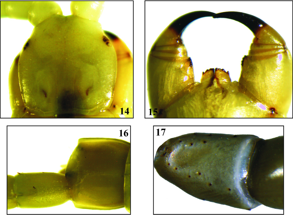
Figs 14-17 View Figs 14-17
Cupipes gervaisianus: Silvestri 1896 , Naturalista Siciliano, An. I, (Nuova Serie), 8: 151.
Cupipes gervaisianus: Kraepelin 1903 , Mitteilungen aus dem Naturhistorischen Museum in Hamburg, 20: 179, fig. 120.
Cupipes gervaisianus: Attems 1908 , Voyage zoologique en Khroumirie ( Tunisie), Rouen: 104.
Cupipes gervaisianus: Brolemann 1921 , Bulletin de la Société des Sciences Naturelles du Maroc, I (3-6): 104.
Cormocephalus gervaisianus: Attems 1930 View in CoL , Das Tierreich, 54: 102, figs 121-122.
Cupipes gervaisianus: Brolemann 1932 , Bulletin de la Société d’Histoire Naturelle d’Afrique du Nord, 23 (2): 50.
Cormocephalus gervaisianus: Dobroruka 1968 View in CoL , Revue de Zoologie et de Botanique Africaines 78(3-4): 204.
Material examined. 1 ex., Tunis Distr., Faculty of Sciences of Tunis, N36°41.31 / E10°40.20, alt. 81 m, urban area with scattered trees of Eucalyptus , Acacia mimosa and Nerium oleander , 24.9.2003 GoogleMaps ; 3 ex., same locality, 29.9.2003 GoogleMaps ; 3 ex., same locality, 15.10.2003 GoogleMaps ; 1 ex., same locality, January 2004 GoogleMaps ; 2 ex., Beja Distr., Nefza, N 36°88/ E9°03, garrigue with Olea europaea , Pistacia lentiscus , 27.2.2004 ; 2 juv., same locality, 18.4.2004 ; 1 juv., same locality, 3.10.2005 ; 2 ex., Jendouba Distr., Feidja N.P., N36°29.76 / E08°18.36, alt. 746 m, oak forest dominated by Quercus faginea with scattered Q. suber and a dense underwood of Erica arborea , Phillyrea angustifolia , Cystus trifolia and Calycotome villosa , 7.3.2004 GoogleMaps ; 1 ex., Jendouba Distr., Col des Ruines Ain Draham , N36°47.24 / E08°41.02, alt. 799 m, oak forest dominated by Q. faginea associated with scattered Q. suber , 18.4.2004 GoogleMaps ; 1 ex., Bizerta Distr., Ichkeul N.P., N37°08.30 / E09°41, alt. 51 m, 7.1.2005 GoogleMaps ; 6 ex., same locality, 8.2.2004 GoogleMaps ; 2 juv., same locality, 24.9.2005 GoogleMaps ; 1 ex., same locality, 3.12.2006 GoogleMaps ; 2 ex., Sousse Distr., Bou Ficha , N36°17.55 / E10°27.30, alt. 6 m, open area with scattered shrubs, 22.3.2005 GoogleMaps ; 1 ex., Ariana Distr., Jebel Ammar, Sidi Thabet , N36°55.05 / E10°04.54, alt. 70 m, maquis with scattered crops of Olea europaea , Callitris articulata and Lavandula multifida , 20.11.2003 GoogleMaps ; 1 ex., same locality, 6.10.2006 GoogleMaps ; 1 ex., Bizerta Distr., Zouaouine , N37°07.49 / E10°04.09, alt. 5 m, 11.1.2004 GoogleMaps ; 1 juv., Tunis Distr. , Jebel Rsas, N36°37.22 / E10°20.15, alt. 600 m, 21.9.2005 GoogleMaps ; 1 ex., Le Kef, N36°11.44 / E08°44.39, alt. 831 m, 27.4.2005 GoogleMaps ; 2 ex., Ariana Distr., El Ghazela, N36°53.32 / E10°10.62, alt. 14 m, houses’ garden, 13.04.2007 GoogleMaps ; 1 ex., Jendouba Distr., Beni Mtir, 19.2.2007 , alt. 500 m; 1 juv., Tunis Distr., Jebel Bou Kornine, 17.2.2004 ; 3 juv., Zaghouan Distr., Jebel Zaghouan, N36°23.269 / E10°08.157, alt. 352 m, 25.2.2007 GoogleMaps ; 1 ex., Ariana Distr., El Ghazela, house’s garden, 20.3.2008 ; 4 ad., 2 juv., Tunis Distr. , Bou Kournine N.P., N36°42.530 / E10°20.680, alt. 105-150 m, Thuya , Eucalyptus / dry river bed, under stones and logs, 4.3.2008 GoogleMaps ; 1 ad., 1 juv., Zaghouan Distr., Jebel Zaghouan, surroundings of the Gouffre du Courant d’Air (small limestone cave), N36°21.980 / E10°05.513, alt. 561 m, Quercus ilex , Pistacia lentiscus , Jasminum fruticans , under stones and leaf litter, 17.3.2008 GoogleMaps ; 3 ad., same mountain, surroundings of the marabout Sidi Bou Gabrine, N36°22.423 / E10°06.328, alt. 642 m, meadows, scattered trees, under stones and leaf litter, 17.3.2008; 1 juv., same locality, 29.3.2008 ; 1 ex., same mountain, collecting along the track between Gouffre Anti Prehistorique (N36°21.595 / E10°05.208) GoogleMaps and Sidi Bou Gabrine (N36°22.423 / E10°06.328), 500-700 m, mixed forest, under stones and leaf litter, 18.3.2008 GoogleMaps ; 3 ad., same mountain, collecting along the track Sidi Bou Gabrine (N36°22.423 / E10°06.328) GoogleMaps – Sidi Abdel kader Cave (N36°22.419 / E10°06.371) GoogleMaps – Saida Mannoubia (N36°22.650 / E10°06.332) GoogleMaps – the asphalt road to Zaghouan (36°22.924 / E 10°06.789), alt. 650-780 m, mixed forest, under stones and leaf litter, 19.3.2008 GoogleMaps ; 5 ad., 4 juv., Beja Distr., 7 km of Zahret Medine, N36°46.857 / E09°01.688, alt. 500 m, limestone hill, shrubs, under stones, 20.3.2008 GoogleMaps ; 1 ad., 1 juv., same district, 13 km of Nefza (road Tabarka-Nefza), N36°57.610 / E08°56.507, alt. 150 m, Pine forest , under stones, 23.3.2008 GoogleMaps ; 2 ad., 3 juv., Jendouba Distr., Tabarka, the Genoese fort and surroundings, N36°57.838 / E08°44.680, alt. 20-30 m, slope facing the sea, grass, rocks scattered trees, under stones and logs, 22.3.2008 GoogleMaps ; 1 ad., same district, Hammam Bourguiba (west of Ain Draham ), N36°45.926 / E08°35.084, alt. 158 m, meadow with scattered trees, under stones, 22.3.2008 GoogleMaps ; 2 ad., Cap Bon Peninsula, Nabeul Distr., near Oued El Abid Dam , N36°49.901 / E10°42.378, alt. 42 m, grass, stones, under stones, 24.3.2008 GoogleMaps ; 3 ad., Zaghouan Distr., Jebel Mansour, close to Sidi Aouidet Village, N36°12.307 / E09°45.588, alt. 514 m, Pine forest , Rosmarinus , under stones and leaf litter, 28.3.2008 GoogleMaps .
Description. Colour yellowish to olive-green. Maximal length, including ultimate legs, ca. 60 mm. Head plate with 2 paramedian sutures occupying the posterior half of head plate (Fig. 14). Antennae composed of 17 articles, the basal 6 glabrous. Tooth plate with 3+1 teeth, the lateralmost one well separated from the others. Trochanteroprefemoral process moderately expanded bearing 4 tubercles (Fig. 15). Legs 1-20 with two spurs on tarsus 2. Spiracles small and rounded. Tergites 1-20 with 2 paramedian sulci (those on first tergite not reaching anterior border), tergite 21 with a complete median suture. Sternites 2 to 20 with two complete paramedian sutures which are well separated anteriorly and posteriorly and narrowing in the middle of sternite. Sternite 21 trapeziform, broader anteriorly. Ultimate pair of legs: coxopleuron with one lateral spine and long and slender process bearing 2 terminal spines; pores not reaching posterior border of coxopleura. The length of coxopleural process varies considerably between specimens. Prefemur, femur and tibia strongly swollen with dorsal furrow, tarsus 1 wider than tarsus 2; prefemur with 2 ventrolateral rows of 3-5 spines, and 8-10 ventromedial and medial teeth and 2-6 dorsomedial ones (Figs 16-17). Pretarsus finely serrated ventrally, longer than tarsus 2.
General distribution. Spain, Algeria, Tunisia, Azerbaijan ( Minelli 2006)
Distribution in Tunisia ( Map 3 View Map 3 ). Widespread in North and Central Tunisia. The range covers the Mogods-Kroumirie Mts. in the west (Feidja, Beni Mtir) and spreads to the eastern part of the Tunisian Ridge (Jebel Mansour and Jebel Zaghouan) and the main coastal area of the Gulf of Tunis (Bizerta, Tunis, Ariana) including the Cap Bon Peninsula (Oued el Abid). Further south it has been found also in the Sahel (Bou Ficha in the district of Sousse). In the past recorded from Tunis, Souk el Arba, Babouch and Ain Draham ( Silvestri 1896, Attems 1908). Dobroruka (1968) reported the species from Savoual (Zaghouan Region) but we were unable to find this locality on the map.
Altitudinal range in Tunisia. Known from sea level up to approx. 800 m.
Habitats. Mixed oak formations dominated by either Quercus faginea or Q. suber , coniferous forests dominated by P. halepensis , mixed forests of Q. faginea and Q. suber , Q. faginea and Pinus pinaster , P. halepensis and Quercus ilex , Q. coccifera and P. halepensis . It is also found in semidry open areas, garigue with Olea europaea , suburban habitats and coastal grasslands.
Remarks. The morphological characters of the specimens examined correspond well with the description of this species given by Attems (1930) which was the most recent description. Cormocephalus , which currently comprises about 70 species, was divided into three supergroups, each composed of several species-groups ( Schileyko and Stagl 2004). In this tentative division, C. gervaisianus belongs to the gervaisianus species group of supergroup III, which is characterized by the presence of complete (rarely somewhat shortened) paramedian sulci on tergite 1; paramedian sulci complete from tergite 2; prefemur of ultimate leg-pair usually bearing ventrolateral spines; coxa of terminal legs with well developed coxopleural process; and pretarsus of ultimate legs longer than tarsus 2.


No known copyright restrictions apply. See Agosti, D., Egloff, W., 2009. Taxonomic information exchange and copyright: the Plazi approach. BMC Research Notes 2009, 2:53 for further explanation.
|
Kingdom |
|
|
Phylum |
|
|
Class |
|
|
Order |
|
|
Family |
|
|
Genus |
Cormocephalus gervaisianus (C.L. Koch, 1841)
| Akkari, Nesrine, Stoev, Pavel & Lewis, John 2008 |
Cormocephalus gervaisianus
| : Dobroruka 1968 |
Cupipes gervaisianus:
| Brolemann 1932 |
Cormocephalus gervaisianus:
| Attems 1930 |
Cupipes gervaisianus:
| Brolemann 1921 |
Cupipes gervaisianus:
| Attems 1908 |
Cupipes gervaisianus:
| Kraepelin 1903 |
Cupipes gervaisianus:
| Silvestri 1896 |