
Ceroctis gyllenhalli (Billberg, 1813)
|
publication ID |
https://doi.org/ 10.11646/zootaxa.4373.1.1 |
|
publication LSID |
lsid:zoobank.org:pub:202AFD20-7B37-405A-9CBA-051EF24E9FB2 |
|
DOI |
https://doi.org/10.5281/zenodo.5990562 |
|
persistent identifier |
https://treatment.plazi.org/id/F72687E4-FFA6-FFFE-FF5F-FB45FCAC4FE4 |
|
treatment provided by |
Plazi |
|
scientific name |
Ceroctis gyllenhalli |
| status |
|
Cercotis gyllenhalli species group
The following three species are phenetically similar and even if their relationships were never studied, we tentatively included them in a phenetic group, endemic to southern African, together with C. gyllenhalli (Billberg, 1813) , which is distributed in South Africa
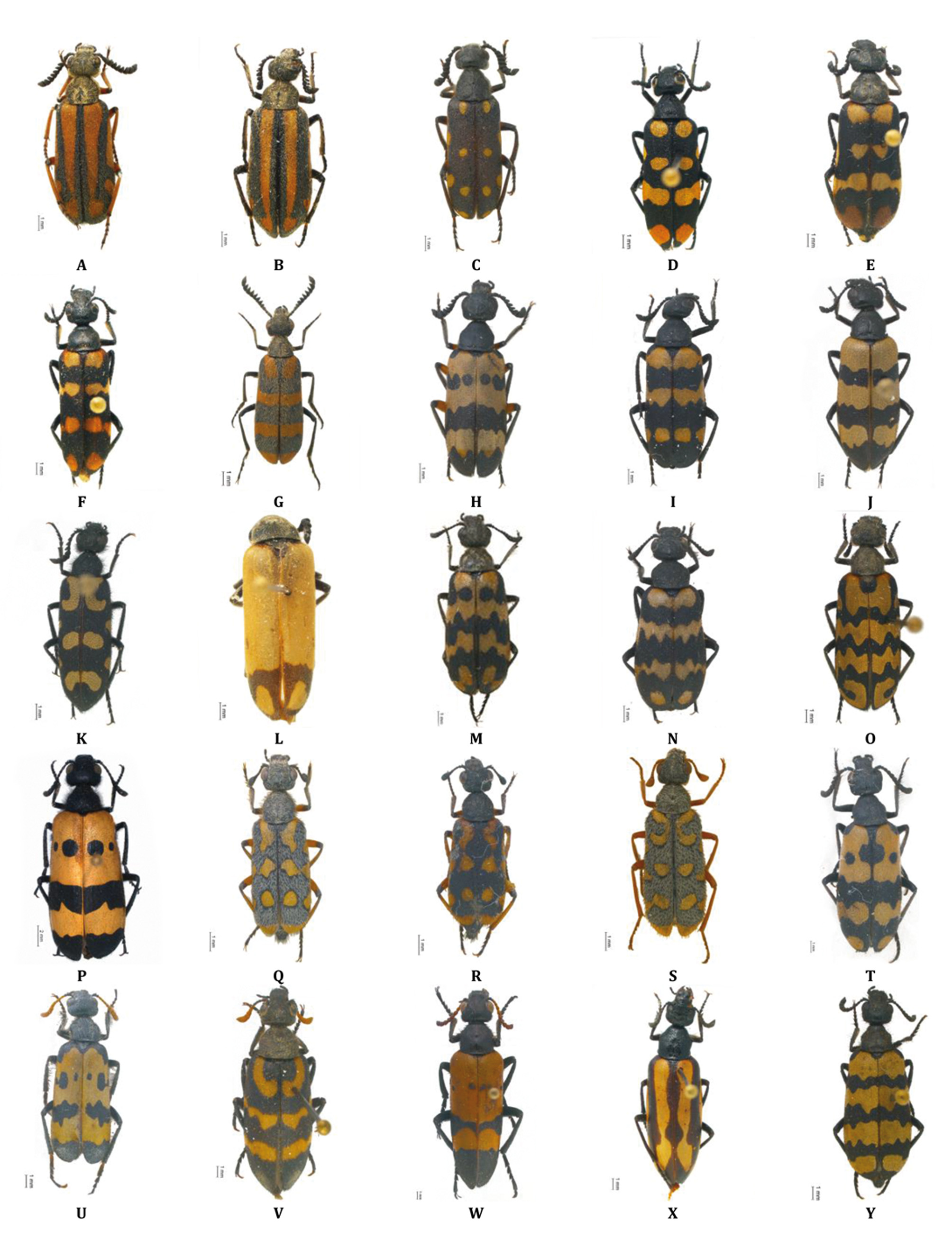
Ceroctis aliena ( Péringuey, 1892) ( Fig. 3D View FIGURE 3 )
Mylabris aliena Péringuey, 1892
Distribution. Namibia , western and northern South Africa.
Material examined and literature records. [Kavango] Kapako: Fontein Omuramba, 17.8833°S 19.7000°E (SMWN). [Kunene] Sesfontein: D265, near Kamanjab, 19.8087°S 14.5128°E (CB). [Otjozondjupa] Omatako: 100 km N Okahandja, 21.0920°S 16.8280°E (CB); Okahandja Townlands, 21.6667°S 17.3333°E (SMWN). [Erongo] Dâures: D3716, Spitzkoppe, 21.8267°S 15.2074°E (CB). Karibib: Noab 69, Karibib, 22.1333°S 15.5667°E (SMWN); C32, 54 km S Karibib, Swakop River, 22.39537°S 15.83432°E (CB). Walvis Bay Rural: Damaraland, Walvis Bay, 22.9167°S 14.4667°E ( Péringuey, 1909). [Khomas] Windhoek Rural: Dudeabib Ost 57, Rehoboth, 23.2059°S 17.6535°E (SMWN). [Hardap] Mariental Rural: C25, 25 km E Derm, 23.5903°S 18.2574°E (CB); Haruchas 156, Mariental, 24.9500°S 18.8500°E (SMWN). Gibeon: Hauchabfontein 5, 24.5000°S 16.0833°E (SMWN); Alwynkop, 24.9167°S 16.2333°E (SMWN). [Karas] Berseba: Hoagces, 25.9167°S 17.9333°E (SMWN). Keetmanshoop Urban: B1, 3.8 km SE Keetmanshoop, 26.61692°S 18.17825°E (CB). Lüderitz: B4, 4 km W Aus, 26.64473°S 16.23154°E (CB); Aus, 26.6667°S 16.2667°E (CP); Plateau 33, Luderitz, 26.6667°S 16.5333°E (SMWN). Keetmanshoop Rural: D608, 35 km S Keetmanshoop, 26.90790°S 18.26411°E (CB). Oranjemund: Boom River course, Kloof W, 22 km N of Orange River (ENE of Rosh Pinah), 27.8333°S 17.0000°E (SMWN); Obibwasser, 28.0833°S 16.7500°E (SMWN); Obib Mts./Dunes, Diamond Area 1, 28.0833°S 16.7500°E (SMWN). Karasburg: M21, 4km N Warmbad, 28.39832°S 18.75766°E (CB); C13, 44,5km N Noordoewer Grape Valley, 28.41803°S 17.44408°E (CB); C10, 23 km N Velloorsdrif, 28.52194°S 19.18402°E (CB). Other records: Ovampoland ( Péringuey 1909); Namibia ( Bologna 2000a; Pitzalis et al. 2014). Remarks. Types of this species were examined at SAMC.
Ceroctis peringueyi (Voigts, 1902) ( Fig. 3E View FIGURE 3 )
Mylabris distincta Péringuey, 1886 , nomen praeoccupatum Zonabris peringueyi Voigts, 1902
Distribution. Namibia and northwestern South Africa.
Material examined and literature records. [Kunene] Epupa: Dunes , 17.3833°S 12.2500°E ( SMWN) GoogleMaps . Opuwo: 30 km WNW Orupembe , 18.1167°S 12.3500°E ( SMWN) GoogleMaps . Khorixas: Krone 721, 20.5373°S 13.9799°E ( SMWN) GoogleMaps ; Duineveld 529, 20.7833°S 14.6333°E ( SMWN) GoogleMaps . [Oshana] Uuvudhiya : Okaukuejo, Etosha, 19.1500°S 15.9333°E ( SMWN) GoogleMaps . [Erongo] Dâures: Tsisab River, Brandberg , 21.0167°S 14.6833°E ( SMWN) GoogleMaps ; Brandberg , 21.1333°S 14.5833°E ( SMWN) GoogleMaps ; Gross Spitzkoppe, 21.8167°S 15.1667°E (CB); Spitskoppe , 21.8518°S 15.1484°E ( SMWN) GoogleMaps . Karibib: B2, 16 km W Karibib , 21.93584°S 15.70561°E (CB) GoogleMaps ; 12 km W of Usakos , 21.9972°S 15.4879°E ( SMWN) GoogleMaps ; 46 km W Usakos ( AMNH) ; Bloemhof 109, 22.4733°S 15.2533°E ( SMWN) GoogleMaps . Arandis: 6 km N Arandis , 22.3667°S 14.9833°E ( SMWN) GoogleMaps ; Rossing Mine , 22.4667°S 15.0333°E ( SMWN) GoogleMaps ; Lower Dome Gorge , 22.4667°S 15.0667°E ( SMWN) GoogleMaps ; Upper Ostrich Gorge , 22.4833°S 14.9833°E ( SMWN) GoogleMaps ; Upper Panner Gorge , 22.4833°S 15.0167°E ( SMWN) GoogleMaps ; Lower Ostrich Gorge , 22.5000°S 14.9667°E ( SMWN) GoogleMaps ; C14, Kuiseb Pass , 23.3045°S 15.7526°E (CB); C14, Kuiseb River GoogleMaps , 23.30457°S 15.77184°E (CB). Walvis Bay Rural: Gorob Mine, Namib Desert Park, 23.5333°S 15.4167°E ( SMWN) GoogleMaps . [Khomas] Windhoek Rural: Windhoek , 22.3400°S 17.0500°E ( SMWN) GoogleMaps ; C14, 41 km N Solitaire, 23.5223°S 15.7832°E (CB). [Hardap] Gibeon : C14, 10 km S Waltevrede, 24.23774°S 15.90401°E (CB); Sesriem 137 GoogleMaps , River, 24.4833°S 15.95°E ( SMWN) GoogleMaps ; Gibeon , 25.1667°S 17.6833°E ( SMWN) GoogleMaps ; Asab , 25.4667°S 17.9500°E ( SMWN) GoogleMaps . [Karas] Keetmanshoop Rural: Koes 202, 25.9500°S 19.1167°E ( SMWN) GoogleMaps ; Khabaus 146, 26.2833°S 18.2333°E ( SMWN) GoogleMaps ; Khabaus 146, 26.3°S 18.2167°E ( SMWN) GoogleMaps ; Khabaus 146, 26.3167°S 18.25°E ( SMWN) GoogleMaps ; Wildheim Ost 384, 26.4833°S 19.5667°E ( SMWN) GoogleMaps ; Swartbaas West 276, 27.0167°S 19.7000°E ( SMWN) GoogleMaps ; Karas distr., C11, 1 km jct. M26, 27.0915°S 19.5372°E (CB) GoogleMaps ; Karas distr., 27.1352°S 19.4941°E (CB); Naochabeb 97, 27.3833°S 18.4667°E ( SMWN) GoogleMaps . Lüderitz : Plateau 38, 26.6667°S 16.5333°E ( SMWN) GoogleMaps . Karasburg : Granau, Warmbad, 27.7333°S 18.3833°E ( SMWN) GoogleMaps .
Other records: Namib Sand Sea desert ( Seely 2012); Namibia ( Bologna 2000a; Pitzalis et al. 2014).
Remarks. Types of this species were examined at SAMC.
Ceroctis trifasciata Pic, 1948 ( Fig. 3F View FIGURE 3 )
Distribution. Namibia (endemic).
Material examined and literature records. [Kunene] Opuwo : 30 km WNW Orupemde , 18.1167°S 12.3500°E ( SMWN) GoogleMaps ; D3710, near Opuwo, 18.1589°S 13.9173°E (CB); D3710, Opuwo, 18.2011°S 13.8994°E (CB); D3709, near Opuwo, 18.5986°S 14.2007°E (CB); Kunene distr. GoogleMaps , C43, 18.6788°S 13.7135°E (CB); Kaokaland, 18.8667°S 12.9833°E (SMWN). Sesfontein: Khowarib River, 19.2667°S 13.8667°E ( SMWN) GoogleMaps ; D2650, near Kamanjab, 19.8087°S 14.5128°E (CB). Kamanjab: C40, 26 km E Kamanjab, 19.6957°S 15.1046°E (CB); C38, 40 km N Outjo, 19.80883°S 15.91281°E (CB); C39, 23 km W Outjo, 20.1798°S 15.9480°E (CB); C39, 29 km W Outjo, 20.19834°S 15.8831°E (CB); Delhi 96, 20.3780°S 15.7280°E ( SMWN) GoogleMaps . Outjo: Ike 346, 19.7533°S 16.6244°E ( SMWN); road Outjo-Kalkfeld 16–20 km S Outjo GoogleMaps , 20.3333°S 16.1500°E (CB). [Oshikoto] Guinas: C38, 1 km jct. with B1, 18.7725°S 17.2491°E (CB). Omuthiyagwiipundi GoogleMaps : 30 km E Etosha N.P., Mokuti Lodge, 18.8000°S 17.0333°E (CB). [Oshana] Uuvudhiya: Okaukuejo / Leeubron, Etosha N.P., 19.0667°S 15.8167°E ( SMWN) GoogleMaps . [Otjozondjupa] Otavi: Etosha N.P., 19.2378°S 17.0878°E ( SMWN) GoogleMaps ; 5 km N Otavi vs. Tsumeb, 19.6239°S 17.3777°E (CB); B8, 10 km E Otavi, 19.6500°S 17.4167°E (CB). Grootfontein: Grootfontein, 19.5667°S 18.1167°E ( SMWN) GoogleMaps . Omatako: Onjoka, Wateberg Plateau Park, 20.4167°S 17.2500°E ( SMWN) GoogleMaps ; Waterberg Plateau Park, 20.5167°S 17.2333°E (CB); D2414, Etjo-Kalkfeld, Dinosaurus Tracks, 21.1156°S 16.4161°E (CB); Okahandja Townlands, 21.6667°S 17.3333°E ( SMWN) GoogleMaps . Otjiwarongo: C33, 2 km N Kalkfeld, 20.8333°S 16.2000°E (CB). Okahandja: Ovita, 21.5228°S 16.2539°E (SMWN); Okahandja, 21.9833°S 16.9167°E (SMWN). [Erongo] Omaruru: Omaruru, 21.4333°S 15.9333°E ( SMWN) GoogleMaps . Karibib: D1935, 30 km NNW Usakos, 21.7833°S 15.5000°E (CB); C28, Boshua Pass, 22.7000°S 16.0333°E (CB). [Omaheke] Steinhausen: C30, 8 km S jct. with C29, 21.8207°S 18.3307°E (CB); Kehoro Sud 939, 22.0833°S 18.6167°E ( SMWN) GoogleMaps ; C29, Omitara, 15 km jct. D1535, 22.2168°S 18.0407°E (CB); B6, 8 km Witvlei, 22.3836°S 18.4078°E (CB). Gobabis: Otjiwarumendu 119, 22.3576°S 18.2870°E (SMWN); Gobabis, C 22, 2 km N jct. B6, 22.4205°S 19.0037°E (CB); Swart Nossob River Gobabis GoogleMaps , 23.1333°S 18.7000°E (SMWN). Kalahari: Gobabis, C 22, 12 km N jct. B6, 22.3613°S 19.0034°E (CB). [Khomas] Windhoek Rural: D1535, near Omitara, 11 km jct. B6, 22.3460°S 17.7240°E (CB); Windhoek ( Pic , 1948, type locality); D1535, Windhoek, 5 km jct. B6, 22.3681°S 17.6675°E (CB); B6, 68 km E Windhoek, 22.3913°S 17.8234°E (CB); Excelsior 286, 22.4500°S 17.6333°E ( SMWN) GoogleMaps ; Neudamm 63, 22.5000°S 17.3500°E (SMWN); Opembamewa Sud, 22.5000°S 17.5000°E (SMWN); Richthofen 126, 22.5667°S 17.7500°E (SMWN); Arnhem 222, 22.7000°S 18.1167°E (SMWN); Gocheganas 26, 22.8333°S 17.1833°E (SMWN); Kos 28, 23.2667°S 16.1333°E (SMWN); D1228, 3 km E Rehoboth, 23.2909°S 17.2012°E (CB). Windhoek East: Windhoek, 22.5700°S 17.0836°E ( Kaszab, 1960, as ab. zumpti) (CB; SMWN); 30 km N Rehoboth GoogleMaps , 23.0468°S 17.1063°E (CB). [Hardap] Rehoboth Rural: B1, km 21, 23.4999°S 17.1284°E (CB); B1, 28.5 km S Rehobothroad GoogleMaps , 23.5833°S 17.1500°E (CB); Bullsport, 24.1495°S 16.36336°E ( Kaszab 1960, as ab. zumpti). Gibeon: C14, Bullsport-Solitaire, 5 km W of Bullsport GoogleMaps , 24.1040°S 16.3093°E (CB); Sesriem 137: River, 24.4667°S 15.9500°E (SMWN); C14, 1 km W Maltahöhe, 24.8589°S 16.9751°E (CB); C19, western slope Tsaris Pass, 24.9346°S 16.4159°E (CB). Mariental Urban: C19, 11 km W Mariental, 24.6167°S 17.8500°E (CB).
Other records: Namib Sand Sea desert ( Seely 2012); Namibia ( Bologna 2000a; Pitzalis et al. 2014).
Remarks. Types of this species were examined at MNHN.
No known copyright restrictions apply. See Agosti, D., Egloff, W., 2009. Taxonomic information exchange and copyright: the Plazi approach. BMC Research Notes 2009, 2:53 for further explanation.
|
Kingdom |
|
|
Phylum |
|
|
Class |
|
|
Order |
|
|
Family |
|
|
Genus |
Ceroctis gyllenhalli
| Bologna, Marco A., Amore, Valentina & Pitzalis, Monica 2018 |
Zonabris peringueyi
| Voigts 1902 |
Mylabris aliena Péringuey, 1892
| Peringuey 1892 |
Mylabris distincta Péringuey, 1886
| Peringuey 1886 |