
Rodriguez, Saarela & Peterson & Valdés-Reyna, 2014
|
publication ID |
https://doi.org/ 10.11646/phytotaxa.185.1.1 |
|
DOI |
https://doi.org/10.5281/zenodo.5156706 |
|
persistent identifier |
https://treatment.plazi.org/id/0389862D-DE16-000E-E3DB-FF7CE22B1FF9 |
|
treatment provided by |
Felipe |
|
scientific name |
Rodriguez |
| status |
|
19. Bromusrichardsonii Link (1833: 281) View in CoL . Figs. 61 View FIGURE 61 , 62 View FIGURE 62 .
Zerna richardsonii (Link) Nevski (1934: 17) . Bromus ciliatus var. richardsonii (Link) Boivin (1967: 521) View in CoL . Zerna canadensis subsp. richardsonii (Link) Tzvelev (1971: 54) . Bromopsis richardsonii (Link) Holub (1973: 168) . Bromopsis canadensis subsp. richardsonii (Link) Tzvelev (1976: 214) . Type:— Hab. in America septentrionali occidentali. Semina misit cl. Dr. Richardson [Grown in Berlin from seed provided by Dr. Richardson] (holotype B, destroyed fide Wagnon 1952).
Bromus purgans var. longispicatus Hooker (1840: 252) View in CoL . Type:— CANADA. Rocky Mountains , T. Drummond s.n. (isotype US- A865460 ! fragm.).
Bromus mucroglumis Wagnon (1952: 67) View in CoL . Bromopsis mucroglumis (Wagnon) Holub (1973: 168) . Type:— UNITED STATES OF AMERICA. Cultivated: grown in the greenhouse of the Botanical Garden, University of Michigan, from seed reproduced by the Soil Conservation Service (A-5712), Albuquerque, New México, and originally collected by Goodding, Locke, & Johnson at South Cave Creek, Chiricahua Mts., Cochise Co., Arizona, 28 July 1948, H.K. Wagnon 1520 (holotype MICH-1108614!, isotype US-2154824!).
Bromus thysanoglottis Soderstrom & Beaman (1968: 509) View in CoL . Type:— MÉXICO. Durango: pine-oak region, Sierra Madre Occidental, Wof Ciudad Durango, 2 mi SW of Buenos Aires, 8800 ft, on precipitous slope, 8 September 1960, in clay soil, J.R. Reeder, C.G. Reeder & T.R. Soderstrom 3348 (holotype US-2457688 !, isotypes ARIZ-246155 !, ARIZ-226130 !, YU- 000863!).
Plants perennial, not rhizomatous. Culms up to 120 cm tall, 1.5–6 mm wide at base, erect or ascending, sometimes decumbent at the base, glabrous below inflorescences; nodes 2–6, glabrous or pubescent. Leaf sheaths glabrous or pubescent to pilose, hairs sometimes restricted to distal sheath margins, hairs up to 1.5 mm long; auricles absent; ligules 0.6–3.3 mm long, glabrous or minutely pubescent, erose-lacerate; blades up to 38 cm × (3–)4–10.5(–13) mm, flat, glabrous or pubescent to pilose, hairs up to 1.5 mm long, margins smooth or serrulate. Panicles 12–35 cm × 2–17.5 cm, open, nodding, branches ascending to spreading or drooping, shorter or longer than spikelets, glabrous, scabrous or pubescent, 1–5 spikelets per branch. Spikelets 1.7–3.2(–3.6) cm long, 3–9(–12)-flowered, elliptic to lanceolate, terete to moderately laterally compressed, rachillas sometimes visible at maturity; glumes glabrous or minutely to strongly pubescent, hairs sometimes restricted to margins, hairs up to 1 mm long, margins hyaline, midnerves glabrous, scabrous or pubescent; lower glumes 5.5–9.5(–12) mm long, narrowly lanceolate to ovate–lanceolate, 1(–3)-nerved, green to purplish-green along and between the nerves; upper glumes (7–)8–12.5(–14.5) mm long, 3-nerved, obovate-lanceolate, green to purplish-green along and between the nerves, apices acute to mucronate, mucros 0.3–1.5(–2) mm long; lemmas (9–)10–13.5(–15) mm × 2–2.8 mm, elliptic to lanceolate, rounded over the backs, apices entire or minutely bifid, the cleft to 0.2 mm long, 7-nerved, green to purplish-green along and between the nerves, margins pubescent, hairs up to 1 mm long, backs glabrous or weakly to densely pubescent proximally and glabrous to scabridulous distally, hairs up to 0.7 mm long; awns 3.1–6.5 mm long, arising 0–0.5 mm below lemma apex, straight; paleas shorter and narrower than lemmas, backs glabrous or puberulent to pubescent, keels glabrous or ciliate, cilia up to 0.4 mm long; anthers 1–2.6(–3.4) mm long; caryopses 7−10 mm long. 2n = 28 ( Mitchell & Wilton 1965, Armstrong 1983, Ward & Spellenberg 1988, Peterson et al. 2001).
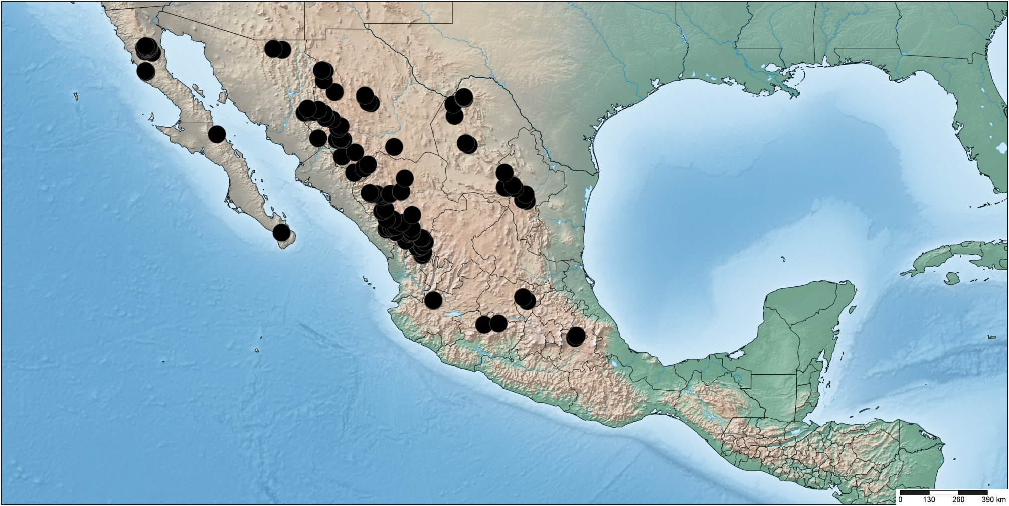
Distribution: ―Native. In México B. richardsonii is known from Baja California, Baja California Sur, Chihuahua, Durango, Coahuila, Michoácan, Nuevo León, Querétaro and Tlaxcala ( Fig. 63 View FIGURE 63 ). In North America, B. richardsonii is generally distributed west of the continental divide from the Yukon territory to central México, with disjunct populations known from the Cypress Hills in southern Alberta and Saskatchewan, the Black Hills in South Dakota and western Texas ( Peterson et al. 2001, Pavlick & Anderton 2007).
Ecology:— Steep to gentle slopes on rock outcrops or wooded habitats in granitic or calcareous soils, often in roadcuts, cliffs and arroyos; associated with Pinus durangensis , P. cooperi Blanco (1949: 185) , P. jeffreyi , P. quadrifolia Parl. ex Sudworth (1897: 17) , P. teocote , P. ayacahuite , Quercus arizonica Sargent (1895: 92) , Q. durifolia Seemen in Loesener (1900: 95), Q. emoryi , Q. rugosa , Q. sideroxyla , A. concolor Lindl. ex Hildebrand (1861: 261) , Pseudotsuga menziesii , Picea engelmannii , Cupressus arizonica , Juniperus deppeana , Arbutus arizonica , A. tessellata Sørensen (1987: 263) , A. xalapensis , Holodiscus dumosus (S. Watson in Brewer 1876: 170) Heller (1898: 4), Arctostaphylos pungens , A. patula Greene (1891: 171) , A. pringlei Parry (1887: 494) , Populus tremuloides Michaux (1803b: 243) , Platanus wrightii , Symphoricarpos oreophilus Gray (1873: 14) , Alnus , Prunus serotina , Pachistima myrsinites , Garrya macrophylla , Cornus stolonifera , Ribes , Salvia , Heuchera Linnaeus (1753: 226) , Lupinus , Senecio , Ceanothus , Baccharis , Brickellia Elliott (1824 [1823]: 290), Cercocarpus , Stevia Cavanilles (1797: 32) , Geranium , Thalictrum , Pedicularis Linnaeus (1753: 607) , Rubus , Sedum Linnaeus (1753 :
ATAXONOMIC REVISION OF BROMUS (POACEAE)
Phytotaxa 185 (1) © 2014 Magnolia Press 113 430), Yucca Linnaeus (1753: 319) , Physocarpus , Silene Linnaeus (1753: 416) and Cerastium Linnaeus (1753: 437) . Elevation: 1500−3250 m. Espejo-Serna (2000) noted B. richardsonii (as B. ciliatus ) to be introduced in México, which is incorrect.
Common Name: ―Richardson’s brome (English).
Comments: ―Plants treated here as B. richardsonii were recognized (in part, see discussion of B. mucroglumis below) as B. ciliatus in several Mexican treatments ( Soderstrom & Beaman 1968, Beetle 1977, 1987, Gould & Moran 1981), while a more recent treatment recognized them as B. richardsonii ( Herrera Arrieta 2001). The distinctions between B. ciliatus and B. richardsonii were, for a long time, unclear. Bromus richardsonii has been variously recognized as a distinct species ( Shear 1900, Hitchcock 1913, Wagnon 1952, Kearney & Peebles 1960, Mitchell & Wilton 1965, Mitchell 1967, Hultén 1968, Welsh 1974, Pavlick 1995, Peterson et al. 2001, Saarela et al. 2005, Pavlick & Anderton 2007, Saarela 2008, Saarela & Peterson 2012) or as a synonym of B. ciliatus ( Hitchcock 1951, Soderstrom & Beaman 1968, Allred 1993, Kartesz & Allen 1999, Espejo-Serna et al. 2000, Douglas et al. 2001, Hatch & Haile 2012). In a detailed study of the complex, Peterson et al. (2001) identified distinctive morphological, cytological and genetic differences that support recognition of these taxa as distinct species (also see Saarela 2008, Saarela & Peterson 2012). Bromus ciliatus is distributed across southern Canada and the United States, except south-central and southeastern U.S.A. ( Pavlick & Anderton 2007); it is not known from México.
Two collections from Municipio de Yécora, Sonora (Reina 98-1389A & Van Devender ; Van Devender 98- 1590, Reina & Trauba) are unusual in having 3-nerved lower glumes and long awns (to 6.5 mm). Aspecimen from Volcán Tequila in Jalisco (Webster 15862, MICH) was treated as B. anomalus by McVaugh (1983), who noted this and another collection (Puga 6347, not seen) to be "robust, up to 1.2 m tall, with woolly sheaths and spikelets 2–4 cm long, suggesting in these characters B. lanatipes (Shear) Rydb. , which has by some authors been treated as a variety of B. anomalus " ( McVaugh 1983: 101) . We treat this collection as B. richardsonii , along with others from Cerro Volcán (Peterson & Rosales 16061, 16067).
114 Phytotaxa 185 (1) © 2014 Magnolia Press
SAARELA ET AL. ATAXONOMIC REVISION OF BROMUS (POACEAE)
Phytotaxa 185 (1) © 2014 Magnolia Press 115
Taxonomic Status of Bromus mucroglumis — Bromus mucroglumis was described from the Chiricahua Mts. in Arizona by Wagnon (1950), but has not generally been recognized until relatively recently, when it was resurrected by Beetle (1987) and Pavlick (1995) ( Peterson et al. 2001). Bromus mucroglumis has since been reported from Colorado, southwestern New México, Arizona (San Francisco Mountains), Chihuahua, Sonora, Durango, Coahuila, Nuevo León and Baja California Sur ( Beetle 1987, Pavlick 1995, Herrera Arrieta 2001, Peterson et al. 2001, Clayton et al. 2002 onwards, Pavlick & Anderton 2007, Shaw 2008). Bromus mucroglumis was included in B. richardsonii by Kearney & Peebles (1960), whereas Allred (1993) treated it as as a synonym of B. lanatipes in New México.
Soderstrom & Beaman (1968) noted difficulties with the circumscription of B. mucroglumis . They found that several paratypes of B. mucroglumis represent multiple species, indicative of some confusion in the limits of the species when it was described by Wagnon (1950). We agree with Soderstrom & Beaman (1968), as did Gould & Moran (1981), that the paratype collections Carter et al. 2341 and Brandegee 73 are B. anomalus , and we recognize the paratype collection Pennell 1929 (GH!, US, not seen), which was treated as B. porteri by Soderstrom & Beaman (1968), as B. frondosus . We have not seen Le Sueur 092 (MO, US), which Soderstrom & Beaman (1968) recognized as B. thysanoglottis (see below for discussion of this taxon).
Peterson et al. (2001) included four individuals of B. mucroglumis (three from Arizona, one from Chihuahua) in their taxonomic study of B. ciliatus and B. richardsonii . In a discriminant analysis, B. mucroglumis was wellseparated from the other taxa, the most important characters and states for its separation being lower glume length, lemma pubescence (hairs not restricted to margins) and adaxially hairy top culm blades. The four individuals of B. mucroglumis fell among the lower range of variation of B. richardsonii or were more or less intermediate between clusters of B. ciliatus and B. richardsonii in multiple bivariate comparisons of morphological and ecological (i.e., elevation) characters. The bivariate plots did not consider glume and lemma pubescence. Based on AFLP data, Peterson et al. (2001) found individuals of B. mucroglumis (all collected from a single population) to fall within a larger cluster comprising individuals of B. richardsonii . Based on their small sample of B. mucroglumis, Peterson et al. (2001) did not make a conclusion on the taxonomic status of B. mucroglumis .
In México it is generally straightforward to identify a plant as a member of the B. richardsonii – B. mucroglumis complex; however, throughout México in the field and in the herbarium we have experienced considerable difficulties understanding the differences between these species, as there is considerable variation in the vestiture of their glumes, lemmas, leaf sheaths and leaf blades of plants. Wagnon (1950) described B. mucroglumis as differing from B. richardsonii by its pubescent nodes, blades pilose above, glumes pubescent to pilose, rarely glabrous, second glumes mucronate and paleas puberulent to pilose. He observed that many plants are intermediate between B. mucroglumis and B. richardsonii , with the variation in the direction of B. richardsonii , and noted that these plants could arbitrarily be placed in either taxon. He suggested there may be introgression with B. richardsonii , and possibly with B. lanatipes . We have seen two of the supposedly intermediate collections cited from Baja California: Wiggins & Demaree 4873 (RSA-POM) and Wiggins & Demaree 4960 (NY, RSA-POM), which have glabrous glumes and lemmas that are pubescent along the margins and weakly to moderately puberulent or pubescent on the backs proximally and glabrous distally, glabrous blades and sheaths pubescent to pilose with stiff hairs. Wagnon (1950) did not indicate in his paper how the specimens varied, but he annotated the two RSA-POM sheets as " Bromus richardsonii Link. Atypical form with pubescent nodes; approaching B. mucroglumis ". Although most specimens from Baja California (Sierra San Mártir) have glabrous nodes, several have weakly pubescent (Moran 15626, SD; Witham 407, SD; Thorne et al. 57251, RSA-POM) or pubescent nodes (Rebman & Vinton 5558, SD, RSA-POM; Moran & Thorne 14127, SD; Thorne et al. 61430, RSA-POM; Noyes et al. 699, RSA-POM). Pubescent nodes are known in B. richardsonii elsewhere in its range ( Peterson et al. 2001, Saarela 2008).
There is considerable variation in the pubescence of the lemmas and glumes in the complex: some plants have lemmas that are pubescent throughout, while others are pubescent along the margins and on the lower backs and glabrous to scabridulous proximally. Similarly, some plants have pubescent glumes, while others have glabrous glumes. These differences in lemma pubescence have been emphasized previously in distinguishing B. mucroglumis from B. richardsonii (e.g., Beetle 1987 (as B. ciliatus ), Herrera Arrieta 2001). However, this range of variation is recognized in B. richardsonii in North America north of México in some recent treatments (e.g., British Columbia: Saarela 2008; California: Saarela & Peterson 2012). Examples of specimens from British Columbia with lemmas pubescent throughout include Malte s.n. (CAN-93967) and Saarela et al. 728 (CAN-590409), and the latter specimen also has pubescent glumes.
116 Phytotaxa 185 (1) © 2014 Magnolia Press
SAARELA ET AL.
Like Wagnon (1950), previous authors have described B. mucroglumis as having blades that are pilose on at least one surface ( Beetle 1987, Pavlick 1995, Pavlick & Anderton 2007). Based on our examination of herbarium specimens we find that leaf blade pubescence varies independently with lemma and glume pubescence. Some plants with pubescent lemmas have pilose blades (e.g., Peterson et al. 15418, 15441, 15443, 16923, 20135; Peterson & Brothers 16999, 17029; Peterson & Annable 12443; Peterson & Cayouette 15354; Peterson & González-Elizondo 16012, 16029) and others have glabrous blades (e.g., Peterson et al. 15416, 16940, 17869, 10052, 20064; Peterson & Sánchez Alvarado 20008; Peterson & Cayouette 15408). Conversely, many plants from México with lemmas pubescent only along the margins have glabrous blades, but there are also several with pubescent blades (e.g., Chihuahua: Peterson & Cayouette 15363, Peterson et al 20069; Durango: Peterson & Cayouette 15387, Peterson & González-Elizondo 16027, Peterson et al. 21197). Although plants with pubescent blades are not known in B. richardsonii in North America north of México ( Peterson et al. 2001, Pavlick & Anderton 2007, Saarela 2008, Saarela & Peterson 2012), we attribute the pubescence in Mexican plants to local variation in this wide-ranging species. Similarly, we find the mucronate glume characters Wagnon used to distinguish B. mucroglumis from B. richardsonii to also vary independently with lemma and glume pubescence, and with leaf blade pubescence. Mucronate second glumes are present in many individuals of the complex in México, as well as in plants as far north as British Columbia ( Saarela et al. 2008).
Given the broad range of variation in the B. mucroglumis – B. richardsonii complex, it is not possible to circumscribe taxa with a suite of co-varying morphological characters. Consequently, we recognize all plants as a single taxon, B. richardsonii . Plants in the southwestern United States recognized as B. mucroglumis should be studied closely to characterize their variation in relation to sympatric B. richardsonii .
Taxonomic status of Bromus thysanoglottis — Bromus thysanoglottis was described from the Sierra Madre Occidental in Durango by Soderstrom & Beaman (1968); they also cited specimens from Chihuahua. They diagnosed this taxon based on the presence of long hairs on the adaxial surface of the blade behind the ligule, and stated this character does not occur in other Bromus species in México and Central America. They considered B. thysanoglottis to be most closely related to B. anomalus . Most subsequent authors have recognized the taxon ( Espejo-Serna et al. 2000, Herrera Arrieta 2001, Clayton et al. 2002 onwards, Herrera Arrieta & Cortés Ortiz 2009, Espejo Serna 2012), but without critical examination. By contrast, Beetle (1977) treated it as a synonym of B. mucroglumis (here included in B. richardsonii ), a circumscription with which we agree. Plants recognized as B. thysanoglottis by previous authors fall within the range of variation recognized here in B. richardsonii .
Specimens Examined:— MÉXICO. Baja California: Arroyo de la quinta, Ejido “El Largo”, 2100 m, 13 October 1990, A . Benítez P . 2837 ( ANSM); along observatory road 1/ 4 mi below gate, [31.0372°N, 115.4542°W], ca. 2650 m, 18 September 1983, R. F GoogleMaps . Thorne, K . Kubitzki, P . Peterson & C . Annable 57251 ( RSA-POM-345660 ); below road Nof Corral de Sam, 31.0667°N, 115.5667°W, 2000 m, 30 July 1970, R GoogleMaps . Moran 18051 ( RSA-POM- 231175 , SD-76461 ); Sierra San Pedro Mártir, Cerro "2828", [31.0372°N, 115.4542°W], 2800 m, 9 August 1969, H. V GoogleMaps . Witham 407 ( SD-71764 , RSA-POM-364159 ); Sierra San Pedro Mártir, La Sanca creek, ca. 5 mi NW of La Grulla, [30.99°N, 115.4°W], 6700 ft [2042 m], 17 September 1930, I. L GoogleMaps . Wiggins & D. Demaree 4873 ( NY, RSA- POM-218732); NW end of the Sierra San Pedro Mártir , 8 mi Nof Vallecitos, 30.9556°N, 115.4239°W, 6800 ft [2073 m], 20 September 1968, D. E GoogleMaps . Breedlove 16309 ( MICH-1119214 ); Sierra San Pedro Mártir, Cerro Vanado Blanco , 30.0667°N, 115.4833°W, 2550 m, 15 September 1968, R GoogleMaps . Moran 15626 ( SD-69097 ); Sierra San Pedro Mártir , S summit ridge, 31.0833°N, 115.4833°W, 2750 m, 15 September 1968, R GoogleMaps . Moran 15638 ( SD-69100 ); La Víbora , Arroyo la Grulla 4 km SW of La Grulla, 30.8667°N, 115.5083°W, 1900 m, 9 August 1977, R GoogleMaps . Moran 24429 ( SD-97767 ); Sierra San Pedro Mártir, Yerba Buena , [31°N, 115.45°W], 2475 m, 16 August 1967, R GoogleMaps . Moran & R. F . Thorne 14127 ( RSA-POM-222140 , SD-76631 ); Sierra San Pedro Mártir , 1 mi Sof La Tasajera, SW of Vallecitos off main road to observatory, [31.0372°N, 115.4542°W], 20 July 1988, S GoogleMaps . Boyd, Ross, Liston , Arnset , Meury , Nordin , Charlton & Thorne 2748 ( RSA-POM-572680 ); Sierra San Pedro Mártir , [31.0372°N, 115.4542°W], 25 September 1982, Adán Preciado 297 ( MEXU-1089736 ); Sierra San Pedro Mártir , at La Encantada, [31.0372°N, 115.4542°W], 7290 ft [2222 m], 20 September 1930, I. L GoogleMaps . Wiggins & D. Demaree 4960 (F- 770041, GH, NY, RSA-POM-14472 , RSA-POM-219089 , US-1614966 ,); Sierra San Pedro Mártir , Eslope of Cerro "2828" on E rim, 30.0333°N, 115.45°W, 2800 m, 24 August 1968, R GoogleMaps . Moran 15408 ( MEXU-167459 , MICH- 1119212 , MSC-241660 , RSA-POM-207303 , SD-68941 US) ; Sierra San Pedro Mártir, La Tasajera region , SW of observatory, ca. 7 mi Sof GoogleMaps the Observatory Road GoogleMaps , [31.0372°N, 115.4542°W], 14 September 1998, J. Rebman & B . Vinton 5558 ( RSA-POM-644316 , SD-152081 ); within 1/ 2 mile of observatory in Sierra San Pedro Mártir National
ATAXONOMIC REVISION OF BROMUS (POACEAE)
Phytotaxa 185 (1) © 2014 Magnolia Press 117 Park, [31.0372°N, 115.4542°W], 9200 ft [2804 m], 19 September 1983, P. M. Peterson & C. R. Annable 01972 ( US); Sierra San Pedro Mártir, Los Llanitos, 30.9667°N, 115.33°W, 2400 m, 17 August 1967, R. Moran & R. F. Thorne 14253 ( MEXU-227200 , RSA-POM-222141 , SD-76636 ); Parque Nacional Sierra San Pedro Mártir, along Observatory road, [31.0372°N, 115.4542°W], 2 September 1985, R. F. Thorne, M. Z. Thorne, L. Thorne & T. Petrella 61490 ( RSA-POM-386718 ); Sierra San Pedro Mártir, Vallecitos , 31.0333°N, 115.45°W, 1 September 1985, R. F. Thorne, M. Z. Thorne, L. Thorne & T. Petrella 61430 ( RSA-POM-346352 , US-3643143 ); Sierra San Pedro Mártir, Wfacing slope along Upper Vallecitos road, ca. 1 mi Sof junction with the observatory road, [31.0372°N, 115.4542°W], 28 August 1988, R. Noyes, R. F. Thorne, P. Peterson & C. Annable 699 ( RSA-POM- 486563 ); Sierra San Pedro Mártir, 2.9 km Sof Vallecitos Meadow GoogleMaps on road to upper Vallecitos Meadow , [30.81°N, 115.22°W] GoogleMaps , 2485 m, 27 August 1988, P. M. Peterson, C. R. Annable, R. F. Thorne & R.D. Noyes 05147 ( US); Sierra San Pedro Mártir , 5.1 km Eof Wpark entrance, [31.0372°N, 115.4542°W] GoogleMaps , 2470 m, 27 August 1988, P. M. Peterson, C. R. Annable, R. F. Thorne & R.D. Noyes 5108 ( CAN, US); Sierra San Pedro Mártir , Vallecitos , [31.0372°N, 115.4542°W] GoogleMaps , 9000 ft [2743 m], 19 September 1983, P. M. Peterson, C. R. Annable, R. F. Thorne & K. Kubitzki 2000 ( CAN, US); Sierra San Pedro Mártir , 55 mi SE of Hwy. 1 on road towards Villecentos at Arroyo Los Alamillos , 31.0112°N, 115.54°W GoogleMaps , 2270 m, 24 September 2000, P. M. Peterson & J. Cayouette 15190 ( CAN, MO, US); Sierra San Pedro Mártir , N-facing ridges of cerro Eof Observatory peak and toward Cañada del Diablo , 31.0333°N, 115.35°W, ca GoogleMaps . 2780 m, 1 September 1985, R. F. Thorne, M. Z. Thorne, L. Thorne & T. Petrella 61465 ( MEXU-835920 ); Sierra San Pedro Mártir , 62 mi SE of Hwy. 1 towards on road towards Villecentos , 31.0332°N, 115.34°W GoogleMaps , 2490 m, 24 September 2000, P. M. Peterson & J. Cayouette 15203 ( CAN, MO, US); Sierra San Pedro Mártir , 62 mi SE of Hwy. 1 towards on road towards Villecentos , 31.0333°N, 115.35°W GoogleMaps , 2490 m, 24 September 2000, P. M. Peterson & J. Cayouette 15209 ( MO, US); 55 mi SE of Hwy. 1 on road towards Villecentos at Arroyo Los Alamillos , 31.0333°N, 115.35°W GoogleMaps , 2270 m, 24 September 2000, P. M. Peterson & J. Cayouette 15183 ( CAN, MO, US); Sierra San Pedro Mártir , Parque Nacional San Pedro Mártir , 13.1 m Eof Wpark entrance at end of road at gate , 2675 m, 28 August 1988, P. M. Peterson, C. R. Annable, R. F. Thorne & R. Noyes 5214 ( US). Baja California Sur: on N ridge of Cerro Azufre , 27.5°N, 112.6°W GoogleMaps , 1600 m, 20 October 1971, R. Moran 18751 ( SD- 80246 ); Sierra de La Laguna, La Laguna , Los Encinos Blancos , 23.5333°N, 109.9833°W GoogleMaps , 1750 m, 27 September 1992, J. L. León de la Luz 5074 ( SD-147259 ). Chihuahua: Arroyo de la Quinta , Ejido “El Largo” , 2340 m, 30 August 1990, A. Benítez 2087 ( ANSM); Sierra Madre Occidental , 5.8 mi Nof Creel on road (Hwy. 25) towards San Juanito , [27.8273°N, 107.6°W] GoogleMaps , 2480 m, 5 October 2000, P. M. Peterson & J. Cayouette 15363 ( CAN, MO, US); at Río Verde Crossing ( Hwy. 24), 21 mi SW of El Vergel , 26.2793°N, 106.49°W, 2330–2360 m, 14 September 2006, P. M. Peterson, F. Sánchez Alvarado & E. P. Gómez Ruíz 20069 ( CAN, US); ca. 22.5 mi NE of Cienegulta de Barranca on road towards Creel , 27.3086°N, 107.5773°W GoogleMaps , 2160 m, 5 September 2003, P. M. Peterson, P. Catalán, C. López-González & G. Villegar-Guzmán 17697 ( CAN, US); ca. 39 km carretera Chihuahua-Namiquipa , [28.76°N, 106.37°W] GoogleMaps , 2300 m, 24 September 1997, M. A. Vergara B. 176 ( MEXU); camino Gauchochic-Creel, 5 km antes del entronque a la Bufa , 27.33°N, 107.58°W, 2700, 24 September 1981, M. E. Siqueiros 1614 ( MEXU- 1089737 ); mountain 15 mi Eof El Vergel GoogleMaps on road to Parral , 26.99°N, 105.43°W GoogleMaps , 2286 m, 21 October 1959, D. S. Correll & H. S. Gentry 23255 ( US-2378629 ); Mpio. Guachochi , Arroyo Chichimuchi , ca. 15 km SE of Norogachi , 26.77°N, 107.01°W], 2146–2153 m, 18 October 2006, R. Bye 34824, M. Luna, M. Mendoaz, L. Mera, D. Castro & E. Chave z ( MEXU); Mpio. Guazapares, Edrainage of Barranca de Chinipas, NW of San Rafael , [27.34°N, 108.5°W], 11 November 1973, R. A. Bye 5860 ( MEXU); Mpio. Madera, Arroyo de la Quinta , Ejido "El Largo", [29.69°N, 108.27°W], 30 August 1990, A. Benítez 2087 ( MEXU-563188 ); Mpio. Madera , Ejido El Largo , [29.69°N, 108.27°W] GoogleMaps , 2100 m, 13 October 1990, A. Benítez P. 2837 ( MEXU-583582 ); Mpios. Guadalupe y Calvo , Nside od Cerro Mohinora ca. 13 mi SW of Guadalupe y Calvo , 25.95°N, 100.96°W GoogleMaps , 2950 m, 20 August 1988, G. Nesom & A. McDonald 6474 ( MEXU-505993 ); near Cumbre Mohinora, Sierra Mohinora , 25.9594°N, 107.05°W GoogleMaps , 3250–3300 m, 13 September 2006, P. M. Peterson, F. Sánchez Alvarado & E. P. Gómez Ruíz 20047 ( CAN, MO, US); near Mirador de Cascada de Basaseachic , 28.1647°N, 108.2°W GoogleMaps , 2022 m, 7 September 2008, P. M. Peterson & J. M. Saarela 22083 ( CAN, MO, US); Parque Cumbres de Majalca , [28.8042°N, 106.485°W] GoogleMaps , 2065 m, 26 September 1997, C. Yen & E. Estrada 8750a ( ANSM); Sánchez , 27.7333°N, 107.6833°W GoogleMaps , 2438 m, 12 October 1910, A. S. Hitchcock 7713 ( US-1009568 ); Sierra Madre Occidental , 48.6 mi Sof Creel on road towards Rocheachic , 27.2785°N, 107.4947°W GoogleMaps , 2630 m, 5 October 2000, P. M. Peterson & J. Cayouette 15371 ( CAN, MO, US); Sierra Madre Occidental , along road to viewing area of Cascada de Basaseachic , 28.1643°N, 108.2°W GoogleMaps , 2220 m, 4 October 2000, P. M. Peterson & J. Cayouette 15355 ( CAN, US); Sierra Madre Occidental , Wof Casas
118 Phytotaxa 185 (1) © 2014 Magnolia Press
SAARELA ET AL.
Grandes, 3 mi Eof Cuesta Blanca, 26.6°N, 107.54°W, 1950 m, 4 September 1958, J. R. Reeder & C. G. Reeder 3232 ( ARIZ-214727 , US-2473580 ); Sierra Madre Occidental , hills Sof Laguna de Babícora, 18 airline km SSW of Gómez Farías, [29.2167°N, 107.8333°W] GoogleMaps , 2250 m, 28 August 1975, N. H. Holmgren & T. K. Lowrey 8028 (MEX- 830906, NY, RSA-POM-339980 ); Soldier Canyon [Arroyo Soldado], [30.0667°N, 108.2333°W] GoogleMaps , 6600 ft [2012 m], 16 September 1903, M. E. Jones s.n. ( RSA-POM-112404 ); Strawberry Creek , NE of Colonia Pacheco, Sierra Madre Occidental, 30.1°N, 108.35°W GoogleMaps , 1900–2000 m, 22–24 September 1934, F. W. Pennell 19171 ( US-1841215 ); Temosachi , Nabogame, 28.5°N, 108.5°W GoogleMaps , 1800 m, 30 August 1988, J. E. Laferriére 1880 ( SD-131507 ); Canyon de St. Diego , 16 September 1891, C. V. Hartman 802 ( NY); SW Chihuahua , August to November 1885, E. Palmer s.n. ( NY); 15.2 mi Eof Ocote on Hwy. 24 towards El Vergel , 26.1392°N, 106.66°W GoogleMaps , 2580 m, 14 September 2006, P. M. Peterson , F. Sánchez Alvarado & E. P. Gómez Ruíz 20064 ( CAN, MO, US); Sierra Madre Occidental, 15.5 mi W. Baquiriachic on Hwy. 16 towards Maycoba, 28.3452°N, 108.27°W GoogleMaps , 1990 m, 4 October 2000, P. M. Peterson & J. Cayouette 15354 ( CAN, US); 5.5 mi Eof Cienegulta de Barranca on road towards Cree, 27.2809°N, 107.74°W GoogleMaps , 1940 m, 5 September 2003, P. M. Peterson , P. Catalán, C. López-González & G. Villegas-Guzmán 17698 ( CAN, MO, US); Sierra Madre Occidental, 38 km Wof Hwy. 45 on road towards Benito Juarez, 29.0769°N, 106.6097°W GoogleMaps , 2230–2450 m, 17 October 1992, P. M. Peterson & C. R. Annable 12576 ( US); Urique , Cuiteco a 8.8 kms al Nde Cuiteco, por la barranca, rumbo a San Rafael, 27°26’10.9”N, 108°00’04.1”W GoogleMaps , 1740 m, 22 September 2002, P. Tenorio , G. Morales & J. Rodriguez 22111 ( US-3589051 ); Bocoyna , entronque carretera Creel , entrada Bocoyna, Ladera S Rancho Cima , Rancho Lucía, 27°41.428’N , 107°24.699” W, 7538 ft, 10 September 2003, R. Bye , M. Mendoza, G. Morales, J. Rodríguez & M. Hilerio 31944 ( US-3589147 ); Bocoyna , Colecta 3, Rancho , 10 September 2003, R. Bye , M. Mendoza, G. Morales, J. Rodríguez & M. Hilerio 3206 ( US-3589105 ); Maguarichi , Poblado de Maguarichic, 2a. Colecta Comida , 24 October 2003, R. Bye , M. Mendoza, G. Morales, J. Rodríguez & M. Hilerio 33069 ( US- 3589136 ). Coahuila : Sierra Zapalinamé, Eof Saltillo, 25.3468°N, 100.9016°W GoogleMaps , 2700 m, 2 September 2005, P. M. Peterson & J. Valdés-Reyna 18784 ( MO, US); Sierra Zapalinamé, 25.3468°N, 100.908°W GoogleMaps , 2800 m, 20 September 2003, P. M. Peterson , J. Valdés-Reyna & R. H. Cárdenas 17869 ( CAN, US); camino de Cuatro, antes de llegar a las Palapas, en ladera baja de exposción noroeste de la sierra Zapalinamé, 25.3678°N, 100.5334°W GoogleMaps , 1940 m, 15 September 2004, J. A. Encina & M.A. Llanas de L. 1207 ( ANSM); 51.6 km SE of Saltillo and 13 km SE of Jame on road to Sierra La Viga , 25.33°N, 100.55°W GoogleMaps , 3240 m, 26 September 1990, P. M. Peterson , C.R. Annable & J. Valdés-Reyna 10052 ( CAN, MO, US); campus of La Escuela Superior de Agricultura, Buenavista, ca. 5 mi SE of Saltillo, 28.25°N, 99.7594°W GoogleMaps , 18 June 1952, F. W. Gould 6381 ( ANSM); Sierra del Carmen , Moreno Canyon, 28.7167°N, 103.0342°W GoogleMaps , 2466 m, 26 August 1997, G. Harper , J. Medel & D. Doan- Cuder s.n. ( ANSM); Cañon del Agua (N-draining), mid-canyon, 2.5 mi Sof ranchito, 27.0653°N, 102.4111°W GoogleMaps , 1830 m, T. Wendt & J. Valdés-Reyna VR-1043 ( MEXU-773997 ); Maderas del Carmen , 13.7 mi NW of Pilares and 0.4 mi Sof El Cinco Junction, 28.9538°N, 102.5853°W GoogleMaps , 2365 m, 7 September 2005, P. M. Peterson & J. Valdés- Reyna 18897 ( CAN, MO, P-03631110 , US); Maderas del Carmen , 13.8 mi NE of Los Pilares, 28.9536°N, 102.5854°W GoogleMaps , 2335 m, 21 September 2007, P. M. Peterson , J.M. Saarela, S. Lara Contreras & J. Reyna Álvarez 20976 ( CAN, MO, US); Maderas del Carmen, 0.5 mi from Campo Uno, up the road towards the summit, 28.9962°N, 102.6113°W GoogleMaps , 2355 m, 22 September 2007, P. M. Peterson , J.M. Saarela, S. Lara Contreras & J. Reyna Álvarez 21020 ( CAN, MO, P-03216869 , US); Maderas del Carmen , 2.8 mi from Campo Uno, up the road towards the summit, 29.0139°N, 102.6034°W GoogleMaps , 2594 m, 22 September 2007, P. M. Peterson , J.M. Saarela, S. Lara Contreras & J. Reyna Álvarez 21035 ( CAN, US); Maderas del Carmen, wooded canyon above Campo El Dos, 28.9899°N, 102.6119°W GoogleMaps , 2280 m, 8 September 2005, P. M. Peterson & J. Valdés-Reyna 18921 ( CAN, US); Maderas del Carmen, wooded canyon above Campo El Dos, 28.9899°N, 102.6119°W GoogleMaps , 2280 m, 8 September 2005, P. M. Peterson & J. Valdés-Reyna 18920 ( ANSM, CAN, MO, US); Maderas del Carmen, 13.3 mi NW of Pilares, 28.9491°N, 102.5862°W GoogleMaps , 2320 m, 7 September 2005, P. M. Peterson & J. Valdés-Reyna 18891 ( CAN, MO, US); Madera del Carmen, between Campo Cinco and Campo Dos, 28.9767°N, 102.6153°W GoogleMaps , 2456 m, 15 September 2012, P. M. Peterson & K. Romaschenko 24508 ( US); Madera del Carmen, 28.9958°N, 102.6114°W GoogleMaps , 2374 m, 16 September 2012, P. M. Peterson & K. Romaschenko 24514 ( US); Madera del Carmen, 29.0042°N, 102.6111°W GoogleMaps , 2434 m, 16 September 2012, P. M. Peterson & K. Romaschenko 24528 ( US) & 24529 ( US); Mpio. Arteaga , Sierra la Marta, el rincón de la sierra y el Moro, límites con Nuevo León, 25.0833°N, 100.1167°W GoogleMaps , 3000 m, 9 October 1992, J. A. Villareal , M. A. Carranza & Grupo de Botanica Forestal s.n. ( US-3288338 ); Sierra del Pino , Ejido Acebuches, Cañón La Vaca, 28.25°N, 99.7594°W GoogleMaps , 1850 m, 2 October 2003, M. A. Carranza & I. Ramírez C-4073 ( ANSM); Sierra las Vigas, al NE de Arteaga, cañon la Carbonera, en la cuesta rumbo al Tunal, 25.45°N ,
ATAXONOMIC REVISION OF BROMUS (POACEAE)
Phytotaxa 185 (1) © 2014 Magnolia Press 119 100.5606°W, 2800 m, M. A. Carranza & J. Valdés-Reyna C-2623 ( ANSM); Sierra Madre Oriental, 34.4 mi NW of San Juanito on road towards Baquiriachic , 28.1068°N, 107.953°W GoogleMaps , 2800 m, 4 October 2000, P. M. Peterson & J. Cayouette 15356 ( CAN, MO, US). Durango: 3 mi Sof Guachichiles, upper slopes of Cerro Huehento , 24.0786°N, 105.7433°W GoogleMaps , 3078 m, 30 September 2008, P. M. Peterson & J. M. Saarela 22453 ( CAN, US); 9.6 mi Wof La Ciudad and 22.6 mi NE of El Palmito on Hwy. 40, 23.6594°N, 105.7403°W GoogleMaps , 2680 m, 9 October 2002, P. M. Peterson & L. E. Brothers 17041 ( US); Mpio Mezquital, 19.7 mi Sof Mezquital on road towards Mesa La Gloria , 23.3172°N, 104.3381°W GoogleMaps , 2500 m, 19 September 2005, P. M. Peterson & F. Sánchez Alvarado 19032 ( CAN, MO, US); Sierra Nevada Occidental, 4 mi Nof Hwy. 40 on road towards Neveros , 23.7309°N, 105.7318°W GoogleMaps , 2850 m, 9 October 2000, P. M. Peterson & J. Cayouette 15408 ( CAN, MO, US); transect from Paseo de Cerro Gordo to the top (cumbre), 23.2086°N, 104.9481°W GoogleMaps , 3136 m, 9 September 2006, P. M. Peterson, F. Sánchez Alvarado 20008 ( CAN, US); 0.8 mi Sof Fancisco I. Madero and 2.3 mi Nof Canoas , 22.6482°N, 104.2895°W GoogleMaps , 2720 m, 2 October 2001, P. M. Peterson & M. S. González-Elizondo 16029 ( CAN, MO, US); 2 mi Sof Fancisco I. Madero and 1.2 mi Nof Canoas , 22.6322°N, 104.2926°W GoogleMaps , 2700 m, 1 October 2001, P. M. Peterson & M. S. González-Elizondo 16012 ( CAN, US); 6 mi SW of San Miguel de Cruces , 24.4036°N, 105.9104°W GoogleMaps , 2610 m, 9 October 2002, P. M. Peterson & L. E. Brothers 17029 ( CAN, MO, P-03216841 , US); Arroyo La Sidia Crosing , 1 mi above La Madroño, 24.4796°N, 105.7889°W GoogleMaps , 2250 m, 8 October 2002, P. M. Peterson & L. E. Brothers 16999 ( CAN, US); Puerto Buenos Aires, at the crest of the Sierra Madre Occidental , Wof Cd. Durango , 2743 m, 10 October 1966, J. R. Reeder & C. G. Reeder 4656 ( MSC-231767 , US-2982193 ); grown in garden in New Haven, Connecticut from seed collected at Puerto Buenos Aires ( J. & C. Reeder 4656), 14 October 1967, J. R. Reeder & C. G. Reeder 4656- G ( MSC-231766 ); 23 mi Nof Hwy. 40 turnoff on road towards San Luis de Villa Corona , 24.0727°N, 105.4898°W GoogleMaps , 2194 m, 29 September 2008, P. M. Peterson & J. M. Saarela 22424 ( CAN, US). Sierra Madre Occidental, at Río Mimbres 45 km Wof Durango on Hwy. 40 towards El Salto , 23.9273°N, 105.13°W GoogleMaps , 2430 m, 8 October 2000, P. M. Peterson & J. Cayouette 15387 ( CAN, MO, US); Sierra Madre Occidental, Sof Durango on road towards La Flor and 4.7 mi Nof Tableteros, 23.7106°N, 104.7206°W GoogleMaps , 2135 m, 1 October 2007, P. M. Peterson, J. M. Saarela, M. S. González-Elizondo, D. J. Rosen & C. S. Reid 21197 ( CAN, MO, P-0361108 , US); Sierra Madre Occidental , 0.5 mi SE of Los Charcos near small arroyo, 23.016°N, 104.29°W GoogleMaps , 2690 m, 21 September 2005, P. M. Peterson & F. Sánchez Alvarado 19047 ( US); Sierra Madre Occidental, 10.8 mi S. of Tableteros on road towards La Flor, 23.5657°N, 104.72°W GoogleMaps , 2860 m, 10 October 2000, P. M. Peterson, J. Cayouette & Y. Herrera-Arrieta 15414 ( US); Sierra Madre Occidental, 11 mi NE of Ojito de Camillones on road towards Papasquiaro , 25.0912°N, 106.136°W GoogleMaps , 2580 m, 12 October 2000, P. M. Peterson, J. Cayouette & M. S. González-Elizondo 15435 ( CAN, MO, US) & 15437 ( CAN, US); Sierra Madre Occidental, 17 mi SW of El Salto on Hwy. 40 towards Mazatlán, just Eof a small puebla called Pericos , 23.7433°N, 105.5507°W GoogleMaps , 2940 m, 8 October 2000, P. M. Peterson & J. Cayouette 15407 ( CAN, US); Sierra Madre Occidental, 3.2 mi SW of Las Bayas on road towards Ceballos , 23.4983°N, 104.86°W GoogleMaps , 2780 m, 10 October 2000, P. M. Peterson, J. Cayouette & Y. Herrera-Arrieta 15420 ( US); Sierra Madre Occidental, 5 mi NW of Vasco Gil on road towards Topia , 25.1425°N, 106.42°W GoogleMaps , 2700 m, 12 October 2000, P. M. Peterson, J. Cayouette & M. S. González-Elizondo 15446 ( US); Sierra Madre Occidental, 5 mi Wof La Ventana on road towards La Guajolota slopes, 22.9667°N, 104.6333°W GoogleMaps , 2486 m, P. M. Peterson & P. Catalán 17764 ( NY, MO, RSA-POM-725716 , US); Sierra Madre Occidental, 5.8 mi Wof El Salto on Hwy. 40 towards La Ciudad , 23.7575°N, 105.4387°W GoogleMaps , 2790 m, 8 October 2000, P. M. Peterson & J. Cayouette 15404 ( CAN, MO, US); Sierra Madre Occidental, at 21 km mark up road towards Topia and 19.8 mi NW of Papasquiaro, 25.1092°N, 105.59°W GoogleMaps , 2650 m, 11 October 2000, P. M. Peterson, J. Cayouette & Y. Herrera-Arrieta 15430 ( US); Sierra Madre Occidental, at 35 km mark up road towards Topia and 28.2 mi NW of Papasquiaro, 25.0773°N, 105.6433°W GoogleMaps , 2850 m, 11 October 2000, P. M. Peterson, J. Cayouette & M. S. González-Elizondo 15431 ( CAN, US); Sierra Madre Occidental, at 47 km mark up road towards Topia and 35.6 mi NW of Papasquiaro, 25.028°N, 105.73°W GoogleMaps , 2610 m, 11 October 2000, P. M. Peterson, J. Cayouette & M. S. González-Elizondo 15434 ( US); Sierra Madre Occidental, SW slope of Cerro Gordo just below twin rock outcrops, 23.209°N, 104.9484°W GoogleMaps , 3130 m, 26 September 2005, P. M. Peterson & F. Sánchez Alvarado 19143 ( CAN, MO, US); Sierra Madre Occidental, 2 mi Nof Tepehuana on road towards Mezquital , 23.3089°N, 104.3457°W GoogleMaps , 2522 m, 11 September 2003, P. M. Peterson & F. Sánchez-Alvarado 17737 ( US); Sierra Madre Occidental, El Salto ( Aserraderos ), 23.78°N, 105.36°W GoogleMaps , 2500–2530 m, 31 August 1934, F. W. Pennel 18537 ( MICH-1119153 , NY, GH, US-1841186 ); Sierra Madre Occidental, SW facing slope of Cerro Gordo , 23.2017°N, 104.9488°W GoogleMaps , 3060 m, 26 September 2005, P. M. Peterson & F. Sánchez Alvarado 19137 ( CAN, MO, US); Sierra Madre Occidental, 2 mi Nof Tepehuana on road towards Mezquital , 23.3089°N, 104.29°W GoogleMaps , 2522
120 Phytotaxa 185 (1) © 2014 Magnolia Press
SAARELA ET AL.
m, 11 September 2003, P. M. Peterson & P. Catalán 17737 ( MO, RSA-POM-725676 ); Sierra Madre Occidental, 0.4 mi Wof Pericos, Eof La Ciudad on Hwy. 40, 23.7404°N, 105.5478°W, 2804 m GoogleMaps , 3 October 2007, P. M. Peterson & J. M. Saarela 21263 ( CAN, MO, P-03631109 , US); Sierra Madre Occidental, 1.6 mi Wof Aserradero La Flor on road towards Las Bayas, 23.524°N, 104.7437°W, 2785 m GoogleMaps , 25 September 2005, P. M. Peterson & F. Sánchez Alvarado 19118 ( CAN, MO, US); Sierra Madre Occidental, 1.5 mi Wof La Flor on road towards Las Bayas, 23.5238°N, 104.744°W, 2910 m GoogleMaps , 10 October 2000, P. M. Peterson , J. Cayouette & Y. Herrera-Arrieta 15416 ( CAN, MO, US); Sierra Madre Occidental, 4.7 mi NE of El Encinal on road towards Minas Promontoria, 25.1885°N, 105.1516°W, 2575 m GoogleMaps , 2 October 2002, P. M. Peterson , M. S. González-Elizondo & L. E. Brothers 16923 ( CAN, MO, US); 6.9 mi NE of El Encinal on road towards Minas Promontoria, 25.2087°N, 105.1433°W, 2800 m GoogleMaps , 3 October 2002, P. M. Peterson , M. S. González-Elizondo & L. E. Brothers 16940 ( CAN, US); Sierra Madre Occidental, 1.8 mi NW of Cienaga de Nuestra Senora on road towards Topia, 25.083°N, 106.3413°W, 2570 m GoogleMaps , 12 October 2000, P. M. Peterson , J. Cayouette & M. S. González-Elizondo 15441 ( CAN, MO, US); Sierra Madre Occidental, Sierra Murata, 5.3 mi Wof La Ventana, 22.9604°N, 104.5003°W, 2540 m GoogleMaps , 20 September 2005, P. M. Peterson & F. Sánchez Alvarado 19043 ( CAN, US); Sierra Madre Occidental, 14.3 mi Eof La Ventenata and 2.7 mi Wof Los Charcos, 23.0053°N, 104.32°W, 2875 m GoogleMaps , 13 September 2003, P. M. Peterson & P. Catalán 17768 ( MO, RSA- POM-721707, US); Sierra Madre Occidental, 14.6 mi Sof Tepehuana and 4.7 mi Nof Mesa la Gloria, 23.15°N, 104.19°W, 27603 m GoogleMaps , 11 September 2003, P. M. Peterson & P. Catalán 17740 ( NY, RSA-POM-725678 , US); Sierra Madre Occidental, 3.2 mi SW of Las Bayas on road towards Ceballos, 23.4983°N, 104.8607°W, 2780 m GoogleMaps , 10 October 2000, P. M. Peterson , J. Cayouette & Y. Herrera-Arrieta 15418 ( CAN, US); Sierra Madre Occidental, 3.5 mi Nof La Flor on road towards Tableteros, 23.5632°N, 104.7158°W, 2880 m GoogleMaps , 10 October 2000, P. M. Peterson , J. Cayouette & Y. Herrera-Arrieta 1541 5 ( CAN, US); Sierra Madre Occidental, 3.9 mi NW of Cienaga de Nuestra Senora on road towards Topia, 25.1056°N, 106.35°W, 2580 m GoogleMaps , 12 October 2000, P. M. Peterson , J. Cayouette & M. S. González-Elizondo 15443 ( CAN, US); 2.8 mi Nof Ciénega del Oro and 7.3 mi Nof Fancisco I. Madero, 22.7434°N, 104.2525°W, 2780 m GoogleMaps , 1 October 2001, P. M. Peterson & M. S. González-Elizondo 16027 ( CAN, MO, US); 5 km al 0 de Los Altares, 24.98°N, 105.92°W, 2410 m GoogleMaps , 19 September 1985, P. Davila , P. Tenorio & I. Solis 103 ( GH, MEXU); 7.5 mi SW of San Miguel de Cruces, 24.3927°N, 105.9244°W, 2490 m GoogleMaps , 9 October 2002, P. M. Peterson & L. E. Brothers 17035 ( CAN, US); Mpio. Durango, 65–75 km SW of Durango City on road to La Flor, 2620 m , 17 September 1979, D. E. Breedlove 44273 ( NY); Mpio. El Mezquital, 16 km de La Guajolota, por el camino a Platanitos, [22.95°N, 104.41°W], 2650 m GoogleMaps , 7 October 1983, S. & M. González & S. Acevedo 2638 ( MEXU-774799 ); Mpio. El Mezquital , camino La Escondida-Charcos a un km del Santo Niño, [22.95°N, 104.41°W] GoogleMaps , 28 October 1992, S. Acevedo 549 ( MEXU-607117 ); Mpio. Santiago Papasquiaro , ca. 145 km al Wde Santyiago Papasquiaro, 2400 mn , 6 October 1985, S. González 3509 ( ANSM); Quebrada de San Juan , 26 road mi Nof railroad at Coyotes, on road to San Luis, 24.25°N, 104.7°W, 1900–2100 m GoogleMaps , 7 August 1955, J. H. Maysilles 8258 ( MICH-1119158 , MEXU-6128 ). Jalisco: Cumbre de Volcán Tequila, 11.2 mi Sof Tequila, 20.7878°N, 103.847°W, 2920 m GoogleMaps , 5 October 2001, P. M. Peterson & O. Rosales 16071 ( CAN, US); Volcán Tequila, along road to microwave station, 20.45°N, 103.8333°W, 8900–9000 ft [2712–2743 m] GoogleMaps , 23 October 1970, G. L. Webster & G. J. Breckon 15862 ( MEXU-792920 , MICH-1119143 ); 9.8 mi Sof Tequila on road to top of Volcán Tequila, 20.795°N, 103.847°W, 2620 m GoogleMaps , 4 October 2001, P. M. Peterson & O. Rosales 16063 ( CAN, US); Cerro de Tequila, Tequila, [20.81°N, 103.84°W], 2400 m GoogleMaps , 28 August 1972, C. L. Diaz Luna 3460 ( RSA-POM-301463 ); 10.1 mi Sof Tequila on road to top of Volcán Tequila, 20.7908°N, 103.847°W, 2670 m GoogleMaps , 4 October 2001, P. M. Peterson & O. Rosales 16067 ( CAN, US). Michoácan: Mpio. Zinapécuaro, Cañada La Yerbabuena, al SW de La Presa Laguna Larga, [19.8669°N, 101.2078°W], 2750 m GoogleMaps , 17 September 1988, M. J. Jasso 534 ( MEXU-720158 ); near Zacapu, 19.8167°N, 101.7833°W GoogleMaps , 28 September 1946, E. Hernández-Xolocotzi, J. Ruppert & J. Guevara X-283 4 ( US- 1962222 ) & X-2824 ( US-1962214 ); 1 km al SE de Zíngiro, sobre el camino a Erongarícuaro , 2400 m , 2 November 1989, J. Rzedowski 49209 ( ANSM). Nuevo León : Cerro El Potosí, Galeana, [24.8667°N, 100.9028°W], 3500 m GoogleMaps , November 1980, J. Ochoa s.n. ( MEXU); Cerro El Potosí, localizado en Galeana, 24.8667°N, 100.2167°W, 2950 m GoogleMaps , 15 August 1998, J. Garza C., M. Castillo B. 207 ( MEXU); Cerro El Potosí, Galeana, [24.82°N, 100.07°W], 3500 m GoogleMaps , November 1980, J. Ochoa 986 ( MEXU-1097966 ). Querétaro : Mpio. Colón, Antena TV El Zamorano, [20.78°N, 100.05°W], 3355 m GoogleMaps , 24 June 1981, A. Mora Benítez & Fco. J. Ramírez Rodríguez 416 ( MEXU- 1089001 ). Mpio. Colón , Cerro Zamorano, 1 km al SW de la cumbre, [20.9333°N, 100.2167°W], 3100 m GoogleMaps , 13 November 1971, J. Rzedowski & R. McVaugh 412 ( MICH-1119154 , NY). Sonora: Cerro de las Flores, summit, [30.93°N, 109.95°W], 2625 m GoogleMaps , M. Fishbein, R. S. Felger, F. Garza S., M. Haro R., J. Malusa & D. Turner 710a
ATAXONOMIC REVISION OF BROMUS (POACEAE)
Phytotaxa 185 (1) © 2014 Magnolia Press 121
(ARIZ-300623, MEXU-945974); Eof Cananea, Sierra de Los Ajos, [30.97°N, 110.32°W], 26 September 1981, A.A. Beetle M-7864 (ARIZ-234250, MEXU); Sierra de los Ajos, Rancho de los Ajos, Cañónj de Evans, [30.97°N, 110.32°W], 1650 m, 8 October 1992, R.S. Felger, M. Fishbein, M. Haro Rodriguez , F. Garza Salazar, J. Malusa & D. Turner 92-801A (ARIZ-300004, MEXU-571407); Sierra de los Ajos, Cañon Frijolito, 30.9333°N, 109.9583°W, 2300 m, 8 October 1992, R.S. Felger, M. Fishbein, M. Haro Rodriguez , F. Garza Salazar, J. Malusa & D. Turner 92-859 (ARIZ-299796, MEXU); Mpio. Yécora, 7.9 km Eof Restaurant La Palmita on MEX 16, Nslopes of Mesa del Campanero, 28.3742°N, 109.0539°W, 1560 m, 19 Sepember 1998, A.L. Reina G. & T.R. Van Devender 98- 1389A (SD-159208); ca. 1 km NNW of Agua Blanca, Sof Cerro Mazatlán, Arroyo Blanca, 28.5458°N, 108.9292°W, 1500 m, 24 Sepember 1998, T.R. Van Devender, A.L. Reina & G. W. Trauba 98-1590 (SD-159207); Cañón Internacional, 23 August 1940, S.S. White 3482 (ARIZ-45609, MICH-1119152, GH); Las Tierritas del Temblor, 20 August 1940, E.A. Phillips 638 (MICH-1119274); Sierra Madre Occidental, 1.7 mi Wof Maycoba on Hwy. 16 towards Yécora, 28.4065°N, 108.68°W, 1720 m, 4 October 2000, P.M. Peterson & J. Cayouette 15350 (CAN, US); Sierra Madre Occidental, 12.3 mi Wof Yécora on Hwy. 16 towards Hermosillo, 28.3772°N, 109.05°W, 1810 m, 3 October 2000, P.M. Peterson & J. Cayouette 15304 (CAN, MO, US); Sierra Madre Occidental, 16 mi Wof Maycoba on Hwy. 16 towards Yécora, 28.4002°N, 108.8°W, 1520 m, 4 October 2000, P.M. Peterson & J. Cayouette 15345 (CAN, MO, US); Wof Yécora on Hwy. 16 towards Hermosilo, 28.3778°N, 109.04°W, 1830 m, 12 October 1992, P.M. Peterson & C.R. Annable 12443 (CAN, US) 3.2 mi Sof La Peña on road towards La Puerta, 23.5561°N, 105.3666°W, 2760 m, 15 September 2003, P.M. Peterson, S. González- Elizondo & G.A. Teña-González 17784 (NY, MO, US, RSA-POM-721712). Tlaxcala: Mpio. Chiautempan, San Rafael Tepatlaxco, 19.2917°N, 98.1125°W, 2620 m, 20 October 1988, J. Barrágan N. 214 (MEXU); Volcán La Malinche, [19.38°N, 98.05°W], 3010 m, 1 November 1985, A. Miranda 229 (MEXU).


| A |
Harvard University - Arnold Arboretum |
| P |
Museum National d' Histoire Naturelle, Paris (MNHN) - Vascular Plants |
| ANSM |
Universidad Autónoma Agraria Antonio Narro |
| R |
Departamento de Geologia, Universidad de Chile |
| F |
Field Museum of Natural History, Botany Department |
| K |
Royal Botanic Gardens |
| C |
University of Copenhagen |
| Nof |
Nanjing University |
| H |
University of Helsinki |
| V |
Royal British Columbia Museum - Herbarium |
| I |
"Alexandru Ioan Cuza" University |
| L |
Nationaal Herbarium Nederland, Leiden University branch |
| NY |
William and Lynda Steere Herbarium of the New York Botanical Garden |
| E |
Royal Botanic Garden Edinburgh |
| S |
Department of Botany, Swedish Museum of Natural History |
| GH |
Harvard University - Gray Herbarium |
| Eslope |
Royal Botanic Garden Edinburgh |
| Sof |
Department of Botany, Swedish Museum of Natural History |
| B |
Botanischer Garten und Botanisches Museum Berlin-Dahlem, Zentraleinrichtung der Freien Universitaet |
| M |
Botanische Staatssammlung München |
| Z |
Universität Zürich |
| T |
Tavera, Department of Geology and Geophysics |
| Wfacing |
Naturhistorisches Museum Wien |
| Eof |
Royal Botanic Garden Edinburgh |
| Wpark |
Naturhistorisches Museum Wien |
| J |
University of the Witwatersrand |
| MO |
Missouri Botanical Garden |
| N |
Nanjing University |
| NE |
University of New England |
| G |
Conservatoire et Jardin botaniques de la Ville de Genève |
| MEXU |
Universidad Nacional Autónoma de México |
| Edrainage |
Royal Botanic Garden Edinburgh |
| Nside |
Nanjing University |
| Wof |
Naturhistorisches Museum Wien |
| W |
Naturhistorisches Museum Wien |
| Nde |
Nanjing University |
| Y |
Yale University |
| Wde |
Naturhistorisches Museum Wien |
| O |
Botanical Museum - University of Oslo |
| TV |
Centro de Estratigrafia e Paleobiologia da Universidade Nova de Lisboa |
No known copyright restrictions apply. See Agosti, D., Egloff, W., 2009. Taxonomic information exchange and copyright: the Plazi approach. BMC Research Notes 2009, 2:53 for further explanation.
Rodriguez
| Saarela, Jeffery M., Peterson, Paul M. & Valdés-Reyna, Jesus 2014 |
Bromus thysanoglottis
| Soderstrom, T. R. & Beaman, J. H. 1968: ) |
Bromus mucroglumis
| Holub, J. 1973: ) |
| Wagnon, H. K. 1952: ) |
Zerna richardsonii (Link)
| Tzvelev, N. N. 1976: ) |
| Holub, J. 1973: ) |
| Tzvelev, N. N. 1971: ) |
| Boivin, B. 1967: ) |
| Nevski, S. A. 1934: ) |
Bromus purgans var. longispicatus
| Hooker, W. J. 1840: ) |