
Astragalus trichopodus (Torr. & A. Gray) A. Gray var. lonchus (M. E. Jones) Barneby, Barneby, Mem.
|
publication ID |
https://doi.org/ 10.11646/phytotaxa.586.1.1 |
|
DOI |
https://doi.org/10.5281/zenodo.7704071 |
|
persistent identifier |
https://treatment.plazi.org/id/0D132D31-FF0E-5FBB-B6AE-ACC6FC982BB0 |
|
treatment provided by |
Plazi |
|
scientific name |
Astragalus trichopodus (Torr. & A. Gray) A. Gray var. lonchus (M. E. Jones) Barneby, Barneby, Mem. |
| status |
|
98. Astragalus trichopodus (Torr. & A. Gray) A. Gray var. lonchus (M. E. Jones) Barneby, Barneby, Mem. View in CoL New York Bot. Gard. 13: 821. 1964
Type: — USA, California, San Diego, 17 March 1882, Jones 3083 (holotype: based on A. leucopsis var. lonchus ): RSA 0002966; isotype: GH00058807 digital image!, CAS 0026629 digital image!, RSA 0002992 digital image!, P00585173 digital image!, NY00005517 digital image!, NY01344200 digital image!, CAS 0027710 digital image!, NY01365131 digital image!, NY01365131 digital image!, MO-149312 digital image !).
Astragalus leucopsis (Torr. & A. Gray) Torr. var. lonchus M. E. Jones, Rev. N. -Amer. Astragalus 119, tab. 19. 1923. — Phaca leucopsis Torr. & A. Gray, Fl. N. Amer. (Torr. & A. Gray) 1(4): 694. 1840. — Astragalus leucopsis (Torr. & A. Gray) Torr., Rep. U. S. Mex. Bound., Bot. [Emory] 56, t. 16. 1859. — Tragacantha leucopsis (Torr. & A. Gray) Kuntze, Revis. Gen. Pl. 2: 946. 1891; Phaca cane s cens Nutt., Fl. N. Amer. (Torr. & A. Gray) 1(2): 344. 1838.
Phaca encenadae Rydb., N. Amer. Fl. 24(6): 336. 1929
Perennial, robust. Stems up to 100 cm long, single, several or multistemmed, almost always erect or diffuse, striate, basally fistulous, strigose to villous, commonly distally white-canescent, trichomes up to 0.7 mm long, ascendant or straight. Stipules 2–7 mm long, semi-clasping, very rarely the basal ones connate, triangular to lanceolate. Leaves 3–20 cm long, leaflets 15–39, 2–27 mm long, lanceolate oblong, elliptic to spathulate, distally obtuse and mucronate or notched, adaxially glabrate or pubescent. Peduncles 4–30 cm long; the racemes 2–17 cm long, lax, flowers 10–50. Flowers green-white, cream, yellowish-cream or with pink-purple veins; the calyx 5–8.8 × 2.5–4.8 mm, strigose, trichomes white or white and black mixed, the tube 3.5–5.6 mm long, campanulate, basally inequilateral, thence oblique to turbinate or rounded, the teeth 0.9–3.7 mm long, lanceolate; the banner 11.3–19 × 5.4–10 mm, rhombic, elliptic, rarely ovate to oblanceolate, slightly notched; the wings 10–16.1 × 1.6–3.2 mm, the claw 4.4–7.9 mm long, the blade 6–9.7 mm long, linear to oblanceolate, straight, distally oblique, slightly incurved; the keel 8.3–13.4 × 2.2–3.4 mm, the claw 4.5–8 mm long, the blade 4.6–6.4 mm long, somewhat rounded-obovate, sometimes triangular-obovate, apically oblique, thence incurved. Pod 1.5–4.5 × 0.8–2.1 cm, deflexed, stipitate (stipe 7–17 mm long, glabrous, continuous with the pod, so the pod firmly attached to the receptacle, lasting for a time, not soon caducous), oblique, ovoid or almost ovoid, inflated, like a bladder, sometimes somewhat laterally compressed, the valves thin, ventrally straight or strongly convex, dorsally more strongly convex than the ventral one, turning papery, ochre and shiny with age, reticulate, septum absent, the valves strigose, trichomes white or sometimes with black ones, rarely apically glabrate or completely glabrate; ovules 10–30; seeds 1.8–3.3 mm long, mitten shape, brown, dark-brown or greenish, smooth, opaque.
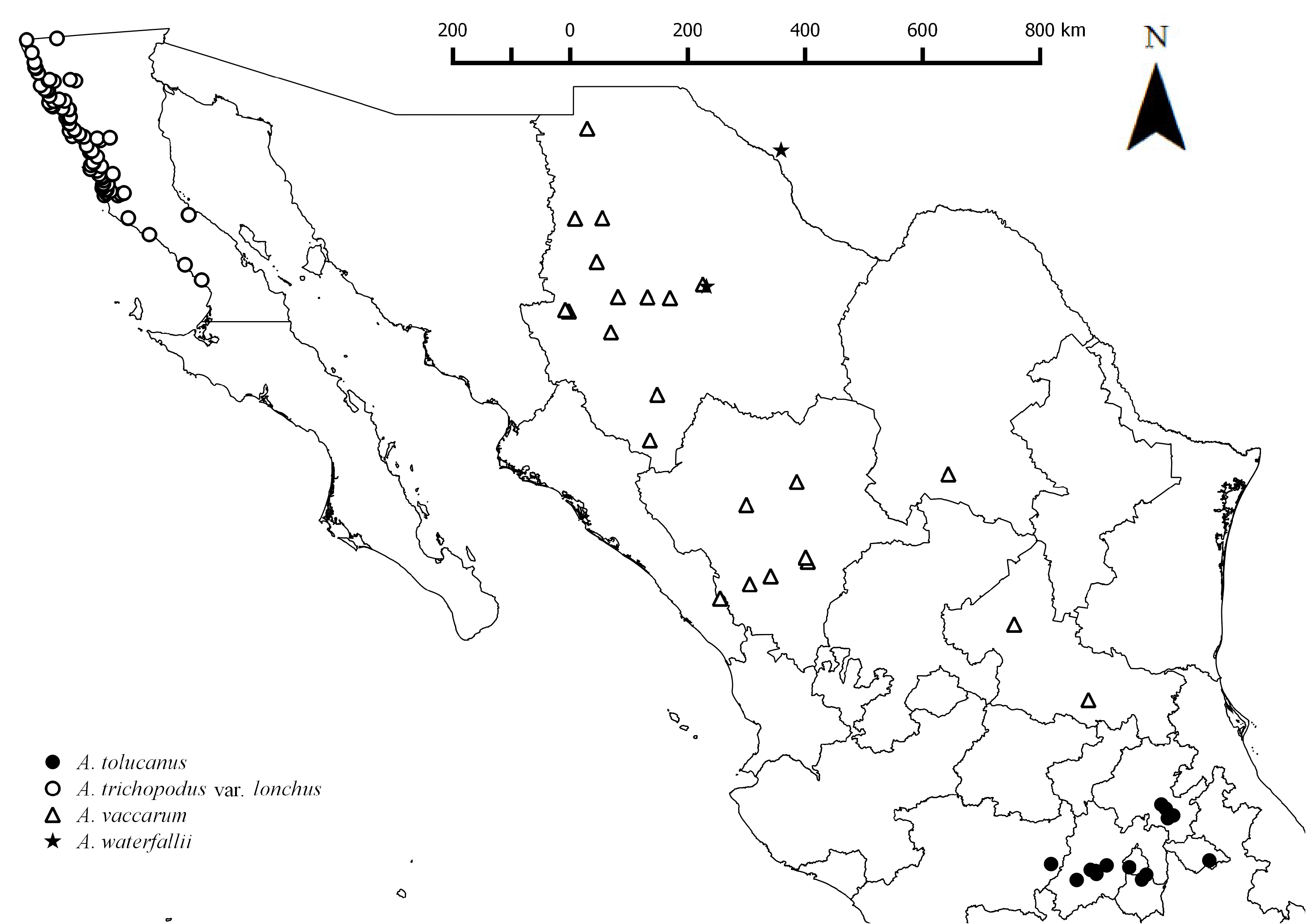
Distribution:— In Mexico recorded from Baja California, along the entire northwestern coast from Rosarito (32°22’N – 117°03’W) to Santa Rosalillita (28°40’N – 114°16’W), plus on Coronado (32°26’N – 117°15’W), Todos Santos (31°48’N – 116°47’W) and Smith Islands (29°02’N – 113°31’W), and. Also, in California ( USA) ( Fig. 27 View FIGURE 27 ).
Habitat:— Volcanic, sandy, clayey, reddish, gravel soils; granite canyons; sandy dunes; coastal plains; along estuaries; roadside; streams; disturbed areas; adjacent sandy coastal cliffs; coastal plains near the coast; dry slopes with chaparral; associated to desert shrublands, columnar cacti, jojoba, and prickly-pear; riparian desert scrubland with salt cedar; oak forest; plains with cactus and maguey; associated with; creeks with thorny scrublands; coastal scrub with maguey; sandy grasslands; desertic scrub with cirio; coastal scrublands with sumac, ash, sycamore; highly disturbed sandy swale with salt bush; 21– 475 m.
Comments:— The northwestern coast and areas adjacent to these in Baja California are characterized by their enormous diversity of Astragalus species. The range of A. t. var. lonchus overlaps with various species with inflated pods, but four of them can be distinguished by the presence of a stipe or a gynophore that elevates the pod above the receptacle, A. fastidius , A. oxyphysopsis , A. oxyphysus and A. t. var. lonchus . Morphologically the four species are almost identical in size, stipule adherence, leaf size, leaflet number, flower color, etc., however they are easily distinguished from each other based on the type of pod inflation and the structure that raises the pod above receptacle. Astragalus trichopodus var. lonchus and A. fastidius have completely inflated pods, but the pod of Astragalus fastidius is elevated from the receptacle by an articulated gynophore, while the one of A. trichopodus var. lonchus is elevated from the receptacle by a continuous stipe with the pod. The other two species, A. oxyphysus and A. oxyphysopsis have fruits that are inflated and bladder-like only in the central part and are laterally strongly flattened.
Specimens examined:— BAJA CALIFORNIA: 1 June 1994, On coastal flats to the west of Mex. Rte. 1 between San Quintin and El Rosario; approx. 9 miles north of El Rosario, J. Rebman 2759, D. Pinkava, ASU Herb. Group ( BCMEX; SD 23 March 1930, Santa Maria Plains 23 miles south of Hamilton’s Ranch , I. L. Wiggins 4538 ( NY) ; 12 April 1882, Encenada , M. E. Jones 3676 ( NY) ; 10 June 1926, Ensenada, M. E. Jones s.n. ( NY) ; 22 March 1971, Ca. 125 mi. SSE of Ensenada, directly NW of Bahia de San Quintin. , T. W. Eakle 56 ( NY) ; 3 January 2000, Tributary of Arroyo El Sauce, 1.75 km (road) north of Hwy 1, about 31 km east of El Rosario, M. Fishbein 4156, S. McMahon, K. Hooper, M. Hedin, M. Lowder ( NY) ; 14 March 1987, S of Valle de las Palmas: a few km S of Valle de las Palmas, side of Hwy 3 (Tecate-Ensenada), R. F. Thorne 62159, A. Liston, O. Mistretta ( NY) ; 17-III1956, East of San Quintin near Santa Maria, J. T. Howell 31058 ( CAS, NY, SD) ; 15 March 1975, West slope of Mesa Redonda. R. Moran 21644 ( NY, SD) ; 2 June 1963, Rancho El Ciprés , R. Moran 11040 ( NY) ; 3 May 1976, Roadside at east end of San Telmo Valley, R. Moran 23097 ( ENCB, NY, SD) ; 23–24 April 1984, Arroyo just W of Hwy 1 near gravel quarry, ca. 6.7 mi. S of Socorro Wash (Arroyo Hondo), R. F. Thorne 58009, W. Wisura, P. Peterson, C. Annable ( BCMEX, MEXU, NY) ; 27 February1934, Two miles from Tijuana on the Ensenada road, R. S. Ferris 8472 ( NY, US); 2 March 1934, North side of Colnett wash at ocean, R. S. Ferris 8516 ( NY) ; 28 November 1987, Vado El Rayado. 7.5 mi S of El Rosario, MA ( Ben ) Franklin 5658, 5671, J. Chandler ( NY) ; 22 May 1974, Punta Banda at Pacific Ocean, ca. 11 mi W of Rte. 1 at Ensenada , Reeves , Hensel , McGill, D. Pinkava P12089, E. Letho ( NY) ; 18 May 1988, Along Mexico Highway 1D near Punta Salsipuedes , 1.5 mi South of La Salina and 1.7 mile north of the Baja Mar Exit, J. L. Reveal 6802 ( CAS, NY) ; 20 December 1975, ± 2 mi. S. of San Quintin, C. D. Johnson 85-75 ( NY) ; 15 March 1980, Islas de Tods Santos, S. island, R. F. Thorne 53971, W. Wisura, D. Michener et al. ( ENCB, NY, SD) ; 1 April 1985, E of San Antonio del Mar: Salina along estuary of Rio San Antonio, R. F. Thorne 58811, D. Charlton ( NY) ; 20 April 1975, 4 miles SE of Santa María , R. Moran 21785 ( NY, SD) ; 9 April 1936, San Quintin, C. Epling s.n., Wm. Stewart ( NY) ; 5 April 1936, San Quintin, C. Epling s.n., Wm. Stewart ( ENCB) ; 15 March 1956, 4 miles east of El Rosario, J. T. Howell 31018 ( CAS, NY, SD) ; 2 March 1930, Flats 1 mile from ocean, 8 miles north of Hamilton Ranch (Santo Domingo), I. L. Wiggins 4292 ( CAS, NY, US); 2 April 1931, Coastal bluff 20 mi. So. of Tijuana, near Rancho Cuevas, I. L. Wiggins 5117 ( CAS, NY) ; 8 April 1931, Santa Maria Plains 10–20 mi. S. of Hamilton Ranch, I. L. Wiggins 5201 ( CAS, NY) ; 10 April 1931, 7 mi. N. of Rosario, I. L. Wiggins 5238 ( CAS, NY, US); 27 April 1978, NE of Ensenada, along Mex Hwy 3, 9.8 mi NE of jct with Mex. Hwy 1, C. R. Broome, B. Ertter, C. Cagle 1932 ( NY) ; 6 June 1972, Rte. 1, 20 mi S of Camalu, D. Pinkava P9034, L. McGill, T. Nash ( NY) ; 30 May 1973, At km. post 120, 3½ mi. N. of Colonet, R. & M. Spellenberg 3306 ( ENCB, NY) ; 3 January 2000, El Consuelo, about 16 km (rd) west of El Rosario on Hwy 1; M. Fishbein 4165, S. McMahon, K. Hooper, M. Hedin, M. Lowder ( NY) ; 27 June 1988, 9 miles North of El Rosario towards San Quintin, along Route 1, T. S. Elias 10902, D. Arias, O. Dorado ( MEXU, NY) ; 5 April 1991, Arroyo Rosarito at crossing of Hwy 1, 47 mi north of Guerrero Negro, S. Boyd 5971, T. Ross ( MEXU, NY) ; 19 March 1993, Approx. 86 km south of San Quintin along Hwy 1, J. Rebman 1646, J. Delgadillo ( NY) ; II-1889, San Quentin Bay , Baja California, E. Palmer 700 ( NY, US); 3 March 1930, Santa Maria Plains and low hills adjacent, 23.5 miles south of Hamilton Ranch, I. L. Wiggins 4307 ( CAS, NY) ; 14 September 1929, Canyon and adjacent slopes, 15–20 miles east of Ensenada on road to Ojos Negros, I. L. Wiggins, Guilliespie 4060 ( NY) ; 12 September 1929, Small valley 32 km north of Ensenada , Wiggins, Guilliespie 4000 ( NY, SD) ; 29 December 1924, Coronado Islands, M. E. Jones s.n. ( CAS, NY) ; 19 June 1971, 8 miles W of Rancho San Jose de San Telmo ( Meling Ranch ), foothills of Sierra San Pedro Martir, I. L. Wiggins 21514 ( CAS, ENCB) ; 13 March 1956, 5.3 miles north of Arroyo Seco, J. T. Howell 30951 ( CAS) ; 4 April 1958, 14 km northwest of Colonia Guerrero, P. H. Raven , H. Lewis, H. Thompson 12191 ( CAS) ; 18 April 1958, 8.5 km east of El Rosario, P. H. Raven , M. Mathias, J. Turner 12440 ( CAS) ; 7 April 1921, T he Gulf of California. Ensenada , Baja Calif, I. M. Johsnton 3019 ( CAS) ; 14 March 1964, Los Coronados , along foot trail on rocky slope near center of island, E. R. Blakley 6442 ( CAS, SD) ; 29 March 1938, Below Ensenada , L. Rowntree s.n. ( CAS) ; 22 February1950, Ensenada, L. S. Rose 50015; 4 March 1979, at Penasco la Lobera , 10 km SSE of Erendira, R. Moran 26560 ( CAS, ENCB, SD) ; 24 February1949, South Todos Santos Island, I. L. Wiggins 11984 ( CAS, US); 8 April 1954, San Carlos Canyon , 1.2 miles below Agua Caliente, I. L. Wiggins 13066 ( CAS) ; 23 May 1941, In adobe soil on hillside 9.5 miles north of Ensenada on old road ro Tijuana, 128 m, I. L. Wiggins 10065 ( CAS, US); 17 June 1971, on S side of San Telmo Valley , 15 miles E of Mexican Highway 1., I. L. Wiggins 21437 ( CAS) ; 20 March 1949, South of Tia Juana, J. H. Thomas 75 ( CAS) ; 25 March 1945, near Laguna Maria, just south of Bahia San Quintin , Bacigalupi 3071 ( CAS) ; 15 March 1987, Arroyo Santo Tomas: Riparian woodland along Rio Santo Tomas , ca. 5 mi from Hwy 1 W along road to La Bocan, R. F. Thorne 62171, A. Liston, O. Mistretta ( MEXU, NY) ; 1 June 1994, On coastal flats to the west of Mex . Rte. 1 between San Quintin and El Rosario; approx. 9 miles north of El Rosario, J. P. Rebman 2759 ( CAS, NY) ; 27 April 1963, 40–45 km S of Tecate along road to Ensenada, H. S. Gentry 19966 ( US); 10 March 1930, Santa Catarina Landing, I. Wiggins 4429 ( MEXU, TEX-LL, US); 25 March 1954, 6.2 miles n. of Colonia Gurrero. Roadside, G. B, Ownbey 2059 ( US); 25 July 1971, 10 km al S de Chapala, carretera al ARCO, Giovannini 13 ( ENCB) ; 31 December 1958, Parte Baja de la Sierra de San Pedro Martir , J Villa 49 ( ENCB) . SONORA: n.d., not exact locality, A. C. V. Schott s.n. ( NY) ; 20 March 2000, Islas Los Coronados, Central part of South Island above military facility, J. Rebman 6244, R. Sosa ( SD) ; 7 April 1994, Mesa San Antonio to the west of Colonet. J. P. Rebman 2526 ( SD) ; 16 October 1971, Occasional on roadside depression 1 mile N of Rancho Santa Gertrudis, R. Moran 18673 ( ENCB, SD) ; 19 March 1968, slope above hotel, NE portion of island, Isla del Sur ; Los Coronados, R. N. Philbrick b66-268 ( SD) ; 14 September 1929, 15–20 miles east of Ensenada on road to Ojos Negros , Wiggins 4060, Guillespie ( SD) ; 17 November 1983, 15 mi. SE of El Rosario., R. F. Thorne 57734, W. Wisura ( SD) ; 20 January 2015, Arroyo Rama; Reserva Natural Valle Tranquilo , J. Riley 212, N. Jensen, J. Campos, J. Simancas, E. Meyer, S. Still ( SD) ; 17 March 2015, Arroyo Escopeta , J. Riley 333, J. Montiel ( SD) ; 2 May 1939, Hamilton Ranch , F. F. Gander 7318 ( SD) ; 20 April 1947, 10 miles S of San Quintin , C. F. Harbison 41813 ( SD) ; 29 May 1966, R. Moran 13194 ( SD) ; 11 April 1982, Near head of canyon, 2.0 km west of Angostura and 14 km northwest of San Vicente, R. Moran 30401 ( SD) ; 28 March 1982, West side of Mesa de Descanso east of Medio Camino, R. Moran 30162 ( SD) ; 9 May 1978, Sierra San Pedro Martir; Roadside 3 km WSW of El Socorro, R. Moran 25788 ( SD) ; 25 April 1976, South side of Arroyo Santo Tomas , R. Moran 22872 ( SD) ; 30 May 1966, Pine Canyon 4 miles southwest of San Vicente, R. Moran 13238 ( SD) ; 1 April 1961, East of crest of hills, Tecate, M. Pitman 2077, P. Fischer, R. H. Hevly ( MEXU, SD) ; 5 March 1982, Punta Banda, southsoutheast of Tres Hermanas Campground, Baurl , Dice 780, Vess, Wier ( SD) ; 12 May 1994, Ensenada , ridge northeast of San Miguel, G. L. Webster 30926 ( SD) ; 8 April 1950, Near San Telmo , F. Wylie s.n. ( SD) ; 20 April 1948, Santo Tomas Valley, F. Wylie s.n. ( SD) ; 21 March 2012, Along coast south of Erendira and north of Colonet ; on a coastal mesa and adjacent upper slopes south of Arroyo Hediondo and on the north side of the dirt road to San Vicente, J. Rebman 22898, S. Vanderplank, et al. ( SD) ; 8 February 2012, Between Arroyo El Socorro and Arroyo El Rosario. Half a kilometer north of N1 within arroyo, J. Montiel 6, J. Riley ( SD) ; 31 March 1992, On dirt road from Colnett to San Antonio del Mar , D. G. Kelch 1846 ( SD) ; 8 February 2012, Near intersection of M1 and Arroyo, J. Riley 3, J. Montiel ( SD) ; 23 February 2001, Venustiano Carranza 1:50,000 topographic map; 11R 05 93 350mE 33 70 000mN, Bahia Falsa, Los Volcanes , 10 km SW of Lazaro Cardenas, along road on south side of cinder cone, M. Baker 13902 ( SD) ; 22 January 1983, Northwest Coast, 7 miles west of Maneadero on road to Punta Banda, B. A. Prigge 4236, L. Prigge ( SD) .
| RSA |
RSA |
| CAS |
USA, California, San Francisco, California Academy of Sciences |
| BCMEX |
BCMEX |
| MEXU |
MEXU |
| BCMEX |
Universidad Autónoma de Baja California |
| SD |
San Diego Natural History Museum |
| NY |
William and Lynda Steere Herbarium of the New York Botanical Garden |
| ENCB |
Universidad de Autonoma de Baja California |
| MEXU |
Universidad Nacional Autónoma de México |
No known copyright restrictions apply. See Agosti, D., Egloff, W., 2009. Taxonomic information exchange and copyright: the Plazi approach. BMC Research Notes 2009, 2:53 for further explanation.
|
Kingdom |
|
|
Phylum |
|
|
Class |
|
|
Order |
|
|
Family |
|
|
Genus |
Astragalus trichopodus (Torr. & A. Gray) A. Gray var. lonchus (M. E. Jones) Barneby, Barneby, Mem.
| Castillón, Eduardo Estrada, Quintanilla, José Ángel Villarreal, Delgado-Salinas, Alfonso & Rebman, Jon P. 2023 |