
Anachemmis, Chamberlin, 1919
|
publication ID |
https://doi.org/ 10.1206/0003-0082(2005)477[0001:AROTNA]2.0.CO;2 |
|
persistent identifier |
https://treatment.plazi.org/id/B60187C3-B966-FFA1-1E52-434B3519F984 |
|
treatment provided by |
Carolina |
|
scientific name |
Anachemmis |
| status |
|
ANACHEMMIS Chamberlin View in CoL
Anachemmis Chamberlin, 1919: 12 View in CoL (type species by original designation A. sober Chamberlin View in CoL ).
DIAGNOSIS: The unusual character combination of three claws plus claw tufts (fig. 1) readily separates members of Anachemmis and its closest relatives from most other North American spiders. Specimens of Zorocrates , which are found from Arizona to Texas and south to Central America, have a tiny remnant of the third claw that is equally obscured by the distal hairs of the tarsal scopula, but Zorocrates species lack true claw tufts (Griswold et al., in press) and have a single retrolateral tibial apophysis on the male palp. Males of Anachemmis differ from those of Titiotus in having two rather than three or four prongs on the retrolateral tibial apophysis, and from those of Socalchemmis and Liocranoides by having a flattened, bladeshaped ventral prong of the apophysis and by having the dorsal prong of the apophysis reduced to a small point. The female epigynum differs from those of Liocranoides species in lacking an anterior hood, from those of Titiotus species in having a much smaller septum, and from those of Socalchemmis species in having Liocranoides like anterior vulval elaborations.
DESCRIPTION: Medium to large spiders, total length of males 7–10, of females 8–13. Carapace oval, widest at rear of coxae II, abruptly narrowed at level of palpi to less than twothirds of maximum width; thoracic groove long, longitudinal, very deep; surface coated with short recumbent and fewer, longer, erect dark setae, erect setae most numerous along midline and in ocular area; eight eyes in two rows; from above, both eye rows slightly recurved; from front, anterior row recurved, posterior row slightly pro curved; anterior median eyes round, smallest; other eyes oval, subequal, with canoeshaped tapeta; anterior median eyes separated by roughly their diameter, slightly closer to anterior laterals; posterior medians separated by roughly their diameter, farther from posterior laterals; lateral eyes of each side separated by less than their diameter; median ocular quadrangle wider in back than in front, wider in back than long; clypeal height about twice diameter of anterior median eyes, corners of clypeus with incised margins that overlie cheliceral boss; chilum weakly sclerotized, divided, composed of two triangular sclerites. Chelicerae vertical, anterior surface with few, erect setae; promargin with three teeth situated at proximal end of fang furrow, most proximal tooth smallest, retromargin with three larger, more distally situated teeth; very short, narrow, Ishaped posterior sclerite present, separating chelicerae at base. Labium short, distally invaginated at middle, reflexed at almost 908 angle relative to sternum. Endites rectangular, distally slightly convergent, with anteromedian scopula and anterolateral serrula consisting of single row of teeth. Sternum rounded, without extensions to or between coxae, with erect setae; posterior margin only slightly extended between coxae IV.
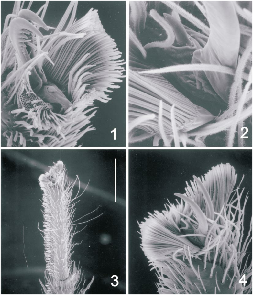
Leg formula 4123. Typical leg spination pattern (only surfaces bearing spines listed): femora: I d111, p011, r121; II d111, p021, r121; III d111, p211, r121; IV d111, p211, r001; patellae III, IV p01 0, r010; tibiae: I, II p010, v442; III, IV d101, p011, v222, r011; metatarsi: I, II v222; III p112, v221r, r112; IV p1 12, v221r, r122; tarsi with three claws and claw tufts (figs. 1–4), superior claws with several weak teeth, most distal teeth largest, inferior claws unarmed; all tarsi with strong ventral scopulae, scopular hairs distinct from those of claw tufts (fig. 1); distal segments with trichobothria in two rows, bases ridged (figs. 5, 6); tarsal organ capsulate (fig. 8); all trochanters strongly notched; males without tibial crack; metatarsi without preening combs.
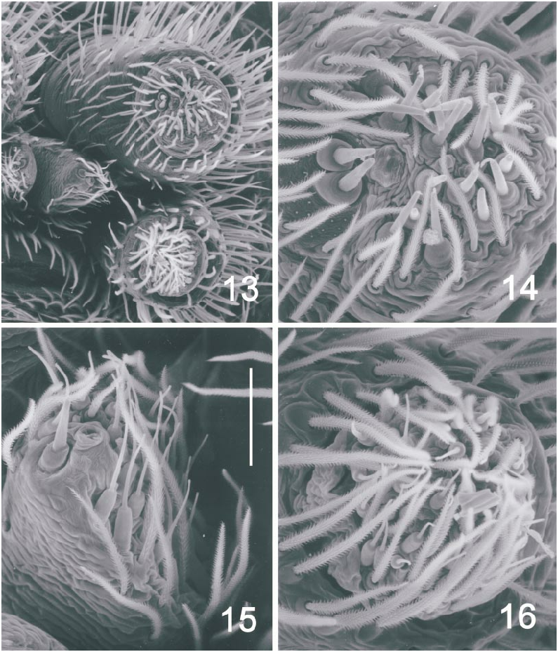
Abdomen without anterior or dorsal scutum; anterior lateral spinnerets large, composed of two articles (figs. 9, 13), distal article with two major ampullate gland spigots and about 10 small piriform gland spigots (figs. 10, 14); posterior median spinnerets composed of one article, small, triangular (figs. 11, 15), those of female expanded posteriorly, where they bear single large and three or four smaller cylindrical gland spigots, preceded anteriorly by smaller aciniform spigots and at least two larger minor ampullate gland spigots; posterior lateral spinnerets composed of two articles, distal article about onefifth as long as proximal article, that of female apparently without cylindrical gland spigots at base, in both sexes with smaller spigots around base and on tip (figs. 12, 16); colulus represented by setae on small lobe.
Male palp with patella not widened, retrolateral tibial apophysis bipartite, ventral prong large, bladeshaped (fig. 18), dorsal prong reduced to tiny point; subtegulum and tegulum with interlocking lobes (fig. 17), median apophysis heavily sclerotized at least distally, embolus short, with shallow division between prolateral prong and copulatory prong, accompanied by hyaline conductor (figs. 19, 20). Female palp with extremely long, dentate claw. Epigynum with large median septum wider anteriorly than posteriorly; spermathecal bulbs situated posterolaterally.
MISPLACED SPECIES: Anachemmis dolichopus Chamberlin (1919) is now placed in Socalchemmis Platnick and Ubick (2001) . For unknown reasons, Roewer (1955) listed Chemmis unicolor Banks (1901) as a member of Anachemmis , but that transfer is incorrect; the placement of Banks’ species will be discussed in detail in a subsequent paper in this series.
KEY TO SPECIES OF ANACHEMMIS View in CoL
1. Males............................. 2
— Females........................... 6
2. Tegulum much wider opposite median apophysis than elsewhere (figs. 21, 25)..... 3
— Tegulum not much wider opposite median apophysis than elsewhere (figs. 29, 33, 37) ................................ 4
3. Tegular edge opposite median apophysis base rounded (fig. 21).............. sober View in CoL
— Tegular edge opposite median apophysis base pointed (fig. 25)............. linsdalei View in CoL
4. Ventral prong of retrolateral tibial apophysis relatively wide at base (fig. 34).. aalbui View in CoL
— Ventral prong of retrolateral tibial apophysis relatively narrow at base (figs. 30, 38)... ................................. 5
5. Dorsal prong of retrolateral tibial apophysis relatively large (fig. 30).......... jungi View in CoL
— Dorsal prong of retrolateral tibial apophysis a tiny spur (fig. 38)............. beattyi View in CoL
6. Widened anterior portion of median epigynal septum relatively short (figs. 31, 35).. 7
— Widened anterior portion of median epigynal septum relatively long (figs. 23, 27, 39).. ................................. 8
7. Epigynal surface opposite sides of median septum with distinct ridge (fig. 35)................................... aalbui View in CoL
— Epigynal surface opposite sides of median septum without distinct ridge (fig. 31)................................. jungi View in CoL
8. Widened portion of epigynal septum with paramedian invaginations (fig. 39)................................. beattyi View in CoL
— Widened portion of epigynal septum without paramedian invaginations (figs. 23, 27).. ................................. 9
9. Epigynal septum relatively wide both anteriorly and posteriorly (fig. 23)..... sober View in CoL
— Epigynal septum relatively narrow both anteriorly and posteriorly (fig. 27)................................. linsdalei View in CoL
Anachemmis sober Chamberlin View in CoL
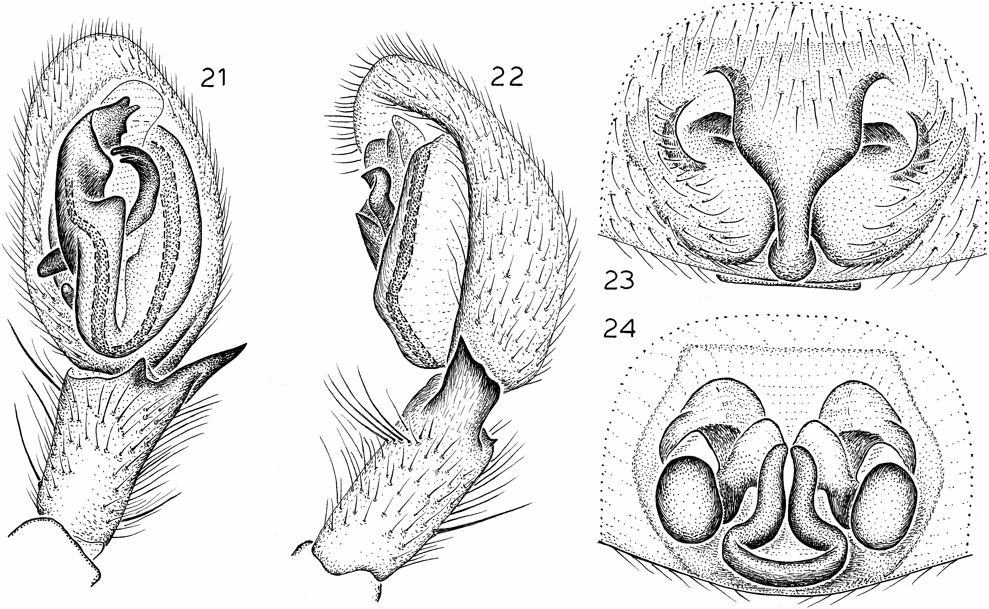
Figures 21–24 View Figs ; Map 1
Anachemmis sober Chamberlin, 1919: 13 View in CoL , pl. 5, fig. 5 (female holotype from Claremont, Los Angeles Co., California, in MCZ, examined).— Silva, 2003: 41, fig. 13d (scanning electron micrograph of male palp).
Anachemmis scaber (lapsus): Roewer, 1955: 607.
DIAGNOSIS: Males closely resemble those of A. linsdalei but differ in having a rounded tegular edge opposite the median apophysis (fig. 21); females also closely resemble those of A. linsdalei but have a wider epigynal septum and more anteriorly restricted lateral epigynal margins (fig. 23).
MALE: Total length 8.0. Carapace light brown, with darker triangular markings radiating from thoracic groove to intercoxal areas; abdomen mottled brownish gray; femora light brown, more distal leg segments grading to dark reddish brown on metatarsi and tarsi. Leg spination: femora: II p121; IV r0 02; tibiae: I d101, r010; II d001, r01 0; tibiae: I, II p110, r110; III p122; IV v222. Tegulum widened opposite median apophysis, with rounded edge (fig. 21); dorsal prong of retrolateral tibial apophysis reduced to tiny, sharp point tip (fig. 22).
FEMALE: Total length 10.3. Coloration as in male. Leg spination: femora: III r112; IV r001; tibiae I p000; III p122; IV v22 2. Epigynum with median septum widened anteriorly and posteriorly, lateral margins restricted to anterior portion of epigynum (fig. 23); spermathecal bulbs oval (fig. 24).
VARIATION: One male taken at Shortcut on the Angeles Crest Highway in the San Gabriel Mountains of Los Angeles County differs from other specimens in having a longer dorsal prong of the retrolateral tibial apophysis. One female from the nearby locality of Switzers Camp differs from most others in having the lateral epigynal bulges relatively ‘‘deflated’’. The geographic congruence of these specimens suggested that a separate species might be present in the San Gabriels, but thanks to the help of Wendell Icenogle, a good series of specimens from these and nearby localities has now been available for study. No other males show the abnormally long dorsal prong of the tibial apophysis, and no consistent differences have been detected among the palpal bulbs of any of these specimens. Another female shows the relatively ‘‘deflated’’ lateral epigynal bulges, but only on one side of the epigynum. We conclude that there is evidence for the existence of only a single species at these sites. Another male from Lake Fulmor in Riverside County has a relatively truncated left embolus tip, but is presumably either broken or represents a developmental deformity, as the right embolus of that specimen appears normal.
MATERIAL EXAMINED: CALIFORNIA: Inyo
Co.: Ninemile Canyon , June 11, 1993, elev. ca. 7000 ft ( R. Robertson, CDU), 1/. Kern Co.: Bakersfield, June 28, 1985 (S. Stockwell, S. Taber, O. Francke, AMNH) , 1?, 1/. Los Angeles Co.: Angeles Crest Highway , N La Canada, first canyon in Angeles National Forest c. 0.25 mi from ranger station, June 27, 1982, running on leaf litter, shaded canyon slope (G. Lowe, AMNH) , 1?; Beverly Glen Canyon , Santa Monica Mountains, May 9, 1953 (W. McDonald, AMNH) , 1/; Big Pines Highway at Grand View Canyon, Angeles National Forest, Jan. 27, 1982, under log, elev. 5900 ft (B. Hebert, CBH) , 1/; Big Rock Creek , Valyermo, June 12, 1943, elev. 4200 ft (K. Cowles, AMNH) , 1/; CharltonChilao P. C., Angeles National Forest , Apr. 28, 1969 (M. Thompson, MET) , 1/; Charmlee County Park, May 13, 1975 (M. Thompson, MET) , 1?, May 3, 1997, elev. 396 m (J. Kempf, UCR) , 1?; Claremont ( R. Chamberlin , MCZ), 1/ (paratype), Apr. 1913 ( R. Chamberlin, MCZ), 1/ (holotype); Eaton Canyon Park, Aug. 5, 1965 (M. Thompson, MET) , 1?, Aug. 16, 1965 (M. Thompson, MET) , 1/, Aug. 4, 1967 (M. Thompson, MET) , 1/, Jan. 18, 1968 (M. Thompson, MET) , 2?, Feb. 19, 1968 (M. Thompson, MET) , 1/, May 5, 1968 (M. Thompson, MET) , 5?, 1/, May 7, 1968 (M. Thompson, MET) , 1?; Glendale , Nov. 25, 1950 (E. Schlinger, AMNH) , 1?, May 25, 1958 (E. Schlinger, AMNH) , 1?, May 10, 2002, in home (K. Schwellenbach, UCR) , 1?; Gold Canyon , San Gabriel Mountains , Mar. 1955, matured Apr. 17 ( R. Schick , AMNH), 1?, Apr. 17, 1955 ( R. Schick , AMNH), 1/, May 6–8, 1955 ( R. Schick , AMNH), 1?, 2/; Grandview Canyon , Big Pines Highway, c. 1 mi W Lake Jackson, June 27, 1982, under log, elev. 5900 ft (G. Lowe, CGL) , 1/; Henninger Flats , Angeles National Forest, Nov. 11–15, 1968 (D. Marqua, MET) , 2/; Hollywood , Oct. 1994 ( R. Vetter, UCR), 1/; Lady Bug Canyon, May 29–June 8, 1969 –1970 (M. Thompson, MET) , 4?; Los Angeles , May 1981 (G. Bakker, CDFA) , 1?; Malibu, midApril 2002 (M. Balducci, UCR) , 1?; Malibu Lagoon , near Serra Road, Dec. 11, 1982, under rock (G. Lowe, CGL) , 1?; Marker Flats , Mount Baldy Road, Apr. 15, 1987, under rock on slope, elev. 6100 ft (G. Lowe, CGL) , 1/; Millard Canyon , Altadena, Dec. 4, 1983, under stone on leaf litter (G. Lowe, CGL) , 1/, July 5, 1984, on rocks and tree trunks at night (C. Lowe, CGL) , 2?, 2/; Millard Canyon , at junction with Canyon Crest Road , San Gabriel Mountains, Altadena, Jan. 18, 2002 (matured Feb. 28, 2002), elev. 1600 ft, under trash on oak duff near stream (W. Icenogle, J. Bond, WRI) , 1?; Old Topanga Canyon Road , c. 1 mi from Topanga Canyon Boulevard and Route 27, Nov. 13, 1982, under rock, under cardboard debris on ground in oak forest (G. Lowe, CGL) , 2/, Sept. 9, 1989, found dead in spider web (B. Hebert, CBH) , 1/; 4723 Palmer Canyon Road , Claremont, July 16, 1998, in kitchen sink (A. Moore, UCR) , 1?; Pasadena , May 2, 1966 (C. Goodpasture, UCR) , 1?; Placerita Canyon Park , 3 mi E Newhall, July 26, 1972, elev. 1550 ft (F. Hovore, WRI) , 1/; May 27, 1976 (P. Sullivan, MET) , 1/; Puente Hills , S Roland Heights , 33.969018N, 117.926888W, Aug. 25–Sept. 4, 1998, dry pitfall, elev. 294 m ( R. Fisher, AMNH), 2/, Nov. 4–8, 2002, same, 1/; San Antonio Canyon, near Claremont, July 1, 1956 (W. Gertsch, V. Roth, AMNH), 6?, 6/; San Antonio Canyon, Mount Baldy Road , 1.5 mi S Lower San Antonio Forest Station, San Gabriel Mountains, May 4, 1996, dead and dried in black widow web in big pipe under road (W. Icenogle, WRI) GoogleMaps , 1?; San Antonio Canyon , 0.5 mi E Sunset Peak, 0.25 mi W Mount Baldy Road, July 9, 2001, elev. 3800 ft, under rock and log in leaf litter beside streamin shaded canyon bottom (W. Icenogle, WRI) , 1?, 1/; San Dimas Canyon , near Claremont , Sept. 2, 1956 ( V. Roth , AMNH), 1/; San Dimas Experimental Forest , Big Dalton Canyon Road, 0.75 mi NE Big Dalton Reservoir at junction of Volfe Canyon, 348109560N, 1178479460W, July 9, 2001 (matured May 25–31, 2002), elev. 1920 ft, oak leaf litter (M. Oxford, UCR) , 1?; Santa Anita Canyon, San Gabriel Mountains, collected as juvenile Nov. 12, 1989, matured in captivity (B. Hebert, CBH) , 1?, collected Apr. 23, 1991, matured May 24, 1991 (B. Hebert, CBH) , 1?; 15 mi W Santa Monica , Mar. 20, 1941 (W. Ivie, AMNH) , 1?; Shortcut , Angeles Crest Highway, San Gabriel Mountains, Apr. 26, 1969 (M. Thompson, MET) , 1?; Sierra Madre , June–July 1977 (G. Gorelick, LACM) , 3?; Spruce Canyon (W branch, San Antonio Canyon ), 0.25 mi W Mount Baldy Road, San Gabriel Mountains, July 5, 2001, elev. 3600 ft, under log beside stream below oaks and alders (W. Icenogle, WRI) , 1?, 1/; Sunland , May 19, 1951 ( T. Tice, AMNH), 1?; Switzers Camp , Angeles Crest Highway, Angeles National Forest, June 27, 1985, elev. 3600–4000 ft (L. Sorkin, AMNH) , 3/; Switzer Picnic Area , upper end of Arroyo Seco Canyon , 0.25 mi S Highway 2, 0.5 mi E junction with Highway N3, San Gabriel Mountains, Apr. 15, 2002 (matured Apr. 27–29, 2002), elev. 3300 ft, under rock in duff below oaks and alders near stream at base of steep, rocky, northfacing canyon side (W. Icenogle, WRI) , 2?, 1/; Tanbark Flats , San Gabriel Mountains, June 20, 1952 (M. Cazier, W. Gertsch, R. Schrammel, AMNH, JCC) , 95?, 130/, Mar. 30, 1957 ( AMNH) , 2/; Tapia Park , Santa Monica Mountains , Mar. 20, 1955, matured in Apr. ( R. Schick, AMNH), 1/; Temescal Canyon , Pacific Palisades, Santa Monica Mountains, Apr. 10, 1995 (B. Olodort, CBH) , 1/; Topanga , off Highway 27 , 34.094838N, 118.601498W, Mar. 13, 2004, elev. 470 m ( R. Keith , D. Palmer, J. Starrett, CDB), 1/; Upper Big Tujunga Canyon , just E Shortcut Ranger Station, San Gabriel Mountains, Aug. 27, 2001, elev. 4200 ft, dead and dried in web of Steatoda atascadera (W. Icenogle, WRI) , 6?, 1/, June 11, 2002, elev. 4200 ft, on wall of 109 diameter pipe under road above small stream, conifer/oak forest (W. Icenogle, WRI) GoogleMaps , 2?. Orange Co.: N Aliso Wood Canyon, E Laguna Beach , 33.558458N, 117.749608W, June 10–Aug. 31, 2001 –2002, dry pitfalls, elev. 71 m ( R. Fisher, AMNH), 2?, 4/; N Aliso Wood Canyon, E Laguna Beach GoogleMaps , 33.567578N, 117.748258W, June 1–Aug. 9, 2000 – 2002, wet and dry pitfalls, elev. 80 m ( R. Fisher, AMNH), 7?, 2/; Chino Hills , Telegraph Canyon GoogleMaps , 33.914488N, 117.785558W, Oct. 29–Nov. 2, 2001, dry pitfall, elev. 238 m ( R. Fisher, AMNH), 1/; Chino Hills , ridge S Telegraph Canyon GoogleMaps , 33.911968N, 117.789108W, Sept. 7–17, 1999, dry pitfall, elev. 358 m ( R. Fisher, AMNH), 1/; Crow Canyon GoogleMaps , 33.602898N, 117.544278W, Nov. 28– Dec. 8, 2000, dry pitfall, elev. 338 m ( R. Fisher , AMNH), 1/; Laguna Beach, June 24, 1931 (W. Ivie, AMNH) GoogleMaps , 1?, July 24, 1931 (W. Ivie, AMNH) , 1/, Dec. 28, 1932, under rock (W. Ivie, AMNH) , 1/, Aug. 17, 2000 ( UCR) , 1/; Limestone Canyon Regional Park, 33.736068N, 117.670488W, June 18–22, 2001, dry pitfall, elev. 341 m ( R. Fisher, AMNH), 1?; Limestone Canyon Regional Park , E The Sinks GoogleMaps , 33.716218N, 117.658928W, July 20–30, 1999, dry pitfall, elev. 453 m ( R. Fisher, AMNH), 1?; Limestone Canyon Regional Park , ENE The Sinks GoogleMaps , 33.722008N, 117.665798W, June 1–Sept. 3, 1998 –2002, pitfall, dry pitfalls, elev. 378 m ( R. Fisher, AMNH), 2?, 2/; N Niguel Hill, NW Laguna Niguel GoogleMaps , 33.536208N, 117.730158W, Aug. 27–31, 2001, Jan. 28–Feb. 1, 2002, dry pitfalls, elev. 195 m ( R. Fisher, AMNH), 2/; N Niguel Hill, NW Laguna Niguel GoogleMaps , 33.538828N, 117.725448W, July 10–Aug. 31, 2000 –2002, dry pitfalls, elev. 132 m ( R. Fish er, AMNH), 3?, 1/; San Joaquin Hills , E branch Laguna Canyon GoogleMaps , 33.594688N, 117.775298W, Sept. 9–13, 2002, dry pitfalls, elev. 175 m ( R. Fisher, AMNH), 2/; Highway 74, 2.5 mi E San Juan Fire Station , Hot Spring Canyon turnoff, Santa Ana Mountains, May 11–22, 2002, elev. 1200 ft, under trash on oak duff beside highway, 60 m from stream (W. Icenogle, WRI) GoogleMaps , 5?, 5/; Silverado Canyon , Santa Ana Mountains, Nov. 20, 1955 ( R., A. Schick, AMNH), 1?; Starr Ranch , 33.630258N, 117.553088W, Sept. 5–Oct. 14, 1998 –2000, elev. 297 m, dry pitfalls ( R. Fisher, AMNH), 4/; N Temple Hill, W Aliso Wood Canyon GoogleMaps , 33.569908N, 117.756338W, July 10–20, 2000, dry pitfall, elev. 215 m ( R. Fisher, AMNH), 1?; N Temple Hill, W Aliso Wood Canyon GoogleMaps , 33.583848N, 117.750308W, May 13–17, 2002, dry pitfall, elev. 206 m ( R. Fisher, AMNH), 1/; Weir Canyon GoogleMaps , 33.809948N, 117.755648W, June 15–25, 1999, dry pitfall, elev. 236 m ( R. Fisher, AMNH), 1?; Weir Canyon GoogleMaps , 33.815558N, 117.747138W, Sept. 19–29, 2000, dry pitfall. elev. 232 m ( R. Fihser, AMNH), 1/. Riverside Co.: Bay Tree Springs , San Jacinto Mountains, Nov. 13, 1976 (M. Long, MET) GoogleMaps , 1/; Chino Canyon , Apr. 20, 1960 (J. Powell, UCB) , 2?; 0.25 mi S Dark Canyon Campground, 2 road mi N junction Hwy 243, San Jacinto Mountains, June 4, 2002, under wood pile on ground near stream, conifer/oak forest (W. Icenogle, WRI) , 1/, June 5, 2002, on side of boulder near stream, conifer/oak forest (W. Icenogle, WRI) , 1/, June 4, 2003, elev. 5765 ft, under wood piece beside recently molted skin, on ground near stream, conifer/oak forest (W. Icenogle, WRI) , 1/; De Luz Road , 3 mi S Murrieta, May 10, 1977, under rock in ravine below live oaks, elev. ca. 2000 ft (W. Icenogle, WRI) , 1/; Idyllwild, San Jacinto Mountains , June 17, 1952 (W. Gertsch, AMNH) , 6?, 5/, July 7, 1953 (W. Gertsch, V. Roth, AMNH), 4?, 4/, 1996, elev. prob. 6000 ft ( UCR) , 1/; James Reserve , San Jacinto Mountains, 9 mi N Idyllwild on Highway 243, 33848.49N, 116846.49W, June 29, 2002, elev. 550 ft, coniferous forest, under granite exfoliations (D., S. Ubick, M. Harvey, CDU) , 3/; Lake Fulmor , James Reserve , San Jacinto Mountains, off Highway 243, elev. 5380 ft (J. Kempf, UCR) , 1/, Aug. 1968 (D. Bixler, CDB), 2?, Sept. 1968 (D. Bixler, CDB), 1/; Santa Margarita Ecological Reserve , W Temecula , 33.445238N, 117.164458W, Sept. 7–17, 1999, dry pitfall, elev. 393 m ( R. Fisher, AMNH), 1/; Santa Margarita Ecological Reserve , W Temecula GoogleMaps , 33.455048N, 117.171238W, May 11–21, 1998, dry pitfall, elev. 786 m ( R. Fisher, AMNH), 1/; Santa Margarita Ecological Reserve , W Temecula GoogleMaps , 33.456898N, 117.168458W, Jan. 28–Feb. 7, 2000, dry pitfall, elev. 788 m ( R. Fisher, AMNH), 1/; Strawberry Creek , 0.25 mi N Highway 74, San Jacinto Mountains, Aug. 12, 2001, elev. 3300 ft, under moist, rotting log beside stream (W. Icenogle, WRI) GoogleMaps , 1/. San Bernardino Co.: Crestline , San Bernardino Mountains, matured Feb. 1997, elev. 5000 ft (J. Klotz, UCR) , 1?; Crestline area , upper end of Waterman Canyon , Highway 18, 0.5 mi NW junction with Highway 138, San Bernardino Mountains, Aug. 30, 2001, elev. 4200 ft, on wall, or dead and dried in spider webs on wall, of long pipe under highway (W. Icenogle, WRI) , 2?, 2/; East Fork Mountain Home Creek , near Highway 38, San Bernardino Mountains, July 6, 1999, under large rock in conifer forest near stream, elev. 5000 ft (W. Icenogle, WRI) , 1/; Fontana , July 16, 1942 (E. Schlinger, AMNH) , 1?, 1/; Forest Falls , Aug. 10, 1985, elev. 7000 ft (D. Bixler, CDB), 2/; Forest Home, Hill Creek, June 11, 1971, in cabin, elev. 6000 ft (D. Lowrie, MCZ) , 1?; Glass Road , San Bernardino Mountains, 1 mi N Highway 38, 348109290N, 1168549000W, May 6, 2001 (matured Apr. 1, 2003), elev. 1820 m, in deciduous duff from Quercus kelloggi (R. Vetter, UCR) , 1/; off Highway 38, East Fork Mountain , E side Home Creek , San Bernardino Mountains , 348079300N, 1168589540W, Feb. 3, 2002 (matured Oct. 26–Nov. 2, 2002), elev. 5120 ft, from dead fern leaves, ferns growing on westfacing rock outcropping on steep canyon wall ( T. Prentice, UCR), 1?; Highway 173 near Lake Arrowhead Village, 348159020N, 1178119590W, July 10, 1999, elev. 5200 ft, along roadside and on hills at night (B. Hebert, CBH) , 3?, 2/; Lake Arrowhead , May 6, 1936 (S. Bishop, AMNH) , 1/; Lytle Creek Canyon , Aug. 20, 1970 (D. Bixler, CDB), 1/, May 13, 1972, elev. 3000 ft (D. Bixler, CDB), 1?, May 16, 1972, in house (D. Bixler, CDB), 1?, June 1, 1973 (D. Bixler, CDB), 1?; Manker Flats Campground, San Gabriel Mountains, May 14, 1992, elev. 6200 ft (B. Hebert, CBH) , 1?, 1/; Mill Creek Canyon, Falls Picnic Area, San Bernardino Mountains, May 15, 1969, molted May 28, 1969, under rock in conifer forest, elev. 6000 ft (W. Icenogle, WRI) , 1?, June 18, 1969, elev. 6000 ft, under wood pieces and rocks (W. Icenogle, WRI) , 1 penultimate /; Mountain Home Creek , Aug. 13, 1959 (W. Gertsch, V. Roth, AMNH), 9/; 209 Pine Oak, Fawnskin, July 21, 1995, in lower level of house in tire chains ( V. Summer, UCR), 1?; Silverwood Lake State Recreation Area, SE end Silverwood Lake , 34.277768N, 117.316948W, Aug. 12–16, 2002, dry pitfall, elev. 1035 m ( R. Fisher, AMNH), 1/; Skinner Creek , just E Highway 38, 1.5 road mi NW junction with road to Forest Falls, San Bernardino Mountains, June 10, 2001, elev. 4200 ft, under rocks and logs beside and above stream in bottom of heavily wooded canyon (W. Icenogle, WRI) GoogleMaps , 2?, 1/; Skinner Ridge , between Skinner Creek and Mountain Home Creek, just SW Highway 38, 348069480N, 1168589530W, Dec. 28, 1983 – Jan. 26, 1984, elev. 4900 ft, pitfall traps, canyon live oak forest, northern exposure (M. Narog, UCR) , 5/; Smiley Park , Running Springs, July 12, 1995, in shower ( UCR) , 1?; Smiley Park , 2 mi S Running Springs on Highway 330 off Fredalba Road, July 10, 1995 (J. Wambaugh, UCR) , 1/; Twin Peaks, San Bernardino Mountains , (K. Wormald, UCR) , 1?, 1/, late May – early June 1996, in house (K. Wormald, UCR) , 1?, 1/, midJuly 1996, male found in house, female outside (K. Wormald, UCR) , 1?, 1/, Aug.– Sept. 1996, elev. 5500 ft (K. Wormald, UCR) , 2/, mid May –mid June 1997 ( R. Vetter, UCR), 11?, June 11, 1997 (K. Wormald, UCR) , 1/. San Diego Co.: De Luz Road, 1 mi N Fallbrook , May 19, 1984, in drain under road (G. Lowe, CGL) , 1?, Aug. 25, 1984 (G. Lowe, CGL) , 1/; Fry Creek , Mount Palomar, Aug. 4, 1984 (D. Boe, UCR) , 1/; near Henshaw , Cleveland National Forest, July 30, 1956 (W. Gertsch, V. Roth, AMNH), 1?, 2/; W side Lake Henshaw, just E route S6 , 33.244388N, 116.764118W, May 16, 2004, elev. 308 m (D. Palmer, P. Paquin, T. Prentice, C. Vink, AMNH) GoogleMaps , 1?; SW end Mendenhall Valley , Palomar Mountain , June 3–July 2, 1997, pitfall, forest (J. George, UCR) , 3?, July 2–Aug. 7, 1997, pitfall, elev. 6000 ft (J. George, UCR) , 2?; Mount Palomar , July 26, 1931 ( R. Chamberlin, AMNH), 1/, June 30, 1956, elev. 3000–5000 ft (W. Gertsch, V. Roth, AMNH), 4?, 7/; Palomar Mountain , July 4, 1967 (B. Kaston, WRIK) , 1?; Palomar Mountain, N Fry Creek, W side route S6, 33.34588N, 116.87948W, May 16, 2004, elev. 1500 m (D. Palmer, P. Paquin, T. Prentice, C. Vink, AMNH) GoogleMaps , 3?, 1/; Palomar Mountain State Park , July 13, 1953 (W., J. Gertsch, AMNH) , 1?, 3/; Palomar Mountain State Park , Doone Trail , 338209290N, 116854950W, Feb. 20, 2003, in duff on creek bed by road, elev. 4639 ft ( R. Vetter, UCR), 1? (matured midMarch 2003). Santa Barbara Co.: Cold Spring Trail, Santa Barbara, Aug. 14, 1959 (W. Gertsch, V. Roth, AMNH), 31/; 5 mi E Gaviota, July 17, 1953 (W., J. Gertsch, AMNH) , 13?, 17/ (one with apparently teratological epigynum); Refugio Rd. , 23 mi W Santa Barbara, Apr. 6– May, 1978–1979 (D. Boe, UCR) , 4/; Santa Barbara , Nov.–Dec. 1950 (H. Shantz, AMNH) , 2?, July 17, 1953 (H. Shantz, AMNH) , 1?, July 27, 1970 (M. Cravens, CDFA) , 1?; 10 mi W Santa Barbara , July 12, 1934 (W. Ivie, AMNH) , 1?, 2/; Sedgwick Ranch Reserve , 348439N, 1208019W, May–June 11, 1997, malaise traps, elev. 1000–1800 ft (E., M. Schlinger, CAS) , 1?, 1/, June 24–July 21, 1997, malaise traps, elev. 800–1500 ft (E., M. Schlinger, CAS) , 3?, Aug. 27– Nov. 1997, same, 3/, May 28, 1997, malaise trap, elev. 1500–2500 ft (E. M. Schlinger, CAS) , 1?; Upper Oso Campground , near Santa Ynez River, Apr. 26–27, 1975, molted before May 18, 1975, under rock (F. Hovore, WRI) , 1?. Tulare Co. : Ash Mountain , Kaweah Power Station # 3, 40 mi NE Visalia, July 3, 1982 (D. Burdick, CAS) , 1?, Mar. 12, 1983 (D. Burdick, CAS) , 1/, June 19–21, 1983 (D. Haines, CAS) , 2?, July 6–10, 1983, in flume (D. Burdick, CDU) , 7?, 3/, July 17, 1983 (D. Burdick, CAS) , 2/, July 31, 1983 ( R. Haines, CDU), 1?, 3/, June 8, 1985 ( R. Haines, CDFA), 2?, 1/, June 7, 1986 ( R. Haines, CDFA), 1?, June 9, 1986 ( R. Haines, CDFA), 2/, June 28, 1986 ( R. Haines, CDFA), 1?, July 12, 1986 ( R. Haines, CDFA), 1/, Aug. 5–Sept. 3, 1995 (D. Burdick, CAS) , 3/, July 24, 1996 (D. Burdick, CAS) , 1?; near Ash Mountain entrance, Sequoia National Park , July 5, 1956, elev. 3700 ft (W. Gertsch, V. Roth, AMNH), 2?, 1/, July 9, 1958 (W. Gertsch, V. Roth, AMNH), 9?, 8/; NE Case Mountain Peak , 36.417908N, 118.793298W, July 14–18, 2003, dry pitfall, elev. 1691 m ( R. Fisher, AMNH), 1?; NE Case Mountain Peak GoogleMaps , 36.421838N, 118.793708W, July 14–18, 2003, dry pitfall, elev. 1646 m ( R. Fisher, AMNH), 1?; NE Case Mountain Peak, N Case Mountain Grove GoogleMaps , 36.413178N, 118.791908W, July 14–22, 2002 –2003, dry pitfall, elev. 1810 m ( R. Fisher, AMNH), 3?; NNE Case Mountain Peak, E of E end of Salt Creek GoogleMaps , 36.420358N, 118.793918W, July 19–22, 2002, dry pitfall, elev. 1644 m ( R. Fisher, AMNH), 1 GoogleMaps ?, 36.421088N, 118.799768W, July 19–22, 2002, dry pitfall, elev. 1819 m ( R. Fisher, AMNH), 2?; NW Case Mountain Peak, S Salt Creek GoogleMaps , 36.414428N, 118.813818W, July 14–22, 2002 –2003, dry pitfalls, elev. 1855 m ( R. Fisher, AMNH), 3?; NW Case Mountain Peak, S Salt Creek GoogleMaps , 36.417818N, 118.819308W, July 14–18, 2003, dry pitfall, elev. 1709 m ( R. Fisher, AMNH), 3?; SE Case Mountain Peak, Case Mountain Grove GoogleMaps , 36.403728N, 118.781908W, July 14–18, 2003, dry pitfall, elev. 1678 m ( R. Fisher, AMNH), 1?; SE Case Mountain Peak, Case Mountain Grove GoogleMaps , 36.405118N, 118.189828W, July 19–22, 2002, dry pitfall, elev. 1805 m ( R. Fisher, AMNH), 1/; SE Case Mountain Peak, Salt Creek Ridge GoogleMaps , 36.397408N, 118.775978W, July 19–22, 2002, dry pitfall, elev. 1801 m ( R. Fisher, AMNH), 1 GoogleMaps ?, 36.398878N, 118.787788W, July 19–22, 2002, dry pitfall, elev. 1848 m ( R. Fisher, AMNH), 1?; Kaweah River , 5 mi E Three Rivers, July 17, 1952, elev. 1258 ft (W. Gertsch, AMNH) GoogleMaps , 1/; 5–10 mi on Mineral King Road from Three Rivers , July 4, 1956, elev. 2000–4000 ft (W. Gertsch, V. Roth, AMNH), 5?, 5/; Moorehouse Creek , near Camp Nelson , July 11, 1958 (W. Gertsch, V. Roth, AMNH), 1?, 5/; 1 mi W Camp Nelson, July 11, 1958 (W. Gertsch, V. Roth, AMNH), 2?; Roads End, Kern River , July 3, 1956 (W. Gertsch, V. Roth, AMNH), 3?, 2/; Sequoia National Park, Kaweah Cave, 36829926.10N, 118849917.40W, Apr. 28, 2004, in cave entrance, elev. 490 m (D. Ubick, CDU) , 1/ (matured May 15, 2004); Soda Creek , W Camp Nelson, July 11, 1958 (W. Gertsch, V. Roth, AMNH), 3/, Sept. 14, 1959 (W. Gertsch, V. Roth, AMNH), 1/. Ventura Co.: Ojai, Mar. 1978 (D. Boe, UCR) , 2/; Reyes Creek , 25 mi SW Lake of the Woods, May 6, 1980, elev. 4000 ft (C. Griswold, UCB) , 1/; Stecker Park , Highway 150 N Santa Paula, 348259N, 119859W, July 4, 1986, elev. 650 ft, from black widow web in restroom (B. Hebert, CBH) , 1?, 1/; Wheeler Springs , July 2, 1958 (W. Gertsch, V. Roth, AMNH, CAS), 17?, 13/; Yerba Buena Road, 2–3 mi N Route 1, June 26, 1983, under rock by stream in canyon (G. Lowe, CGL) , 1?.
DISTRIBUTION: Southern California (map 1).
NATURAL HISTORY: Collection records indicate that Anachemmis sober occurs in forests, primarily oak but also coniferous, at elevations from 70 to 2000 m. Specimens have
Map 1. Western North America, showing records of Anachemmis sober (open circles), A. linsdalei (filled circles), A. jungi (filled squares), A. aalbui (open square), and A. beattyi (triangles).
been found beneath rocks, logs, and other ground litter, in and on leaf litter, on tree trunks, in a cave entrance, and in human structures, such as houses, culverts, and a flume. Several collections are from pitfall and malaise traps and of dead individuals in spider webs, including those of Latrodectus and Steatoda . The 700 specimens examined indicate that both sexes occur year round, with females being more commonly collect ed, and a peak abundance from May to August (chart 1). That this species may be very common is documented by a single June day’s collection, at Tanbark Flats, Los Angeles County, of 95 males and 130 females.
Anachemmis linsdalei , new species
Figures 1–20 View Figs View Figs View Figs View Figs View Figs , 25–28 View Figs ; Map 1
TYPES: Male holotype and female allotype taken in house at Hastings Natural History State Reserve , Monterey Co. , California (Jan. 24–25, 1946; J. Linsdale), deposited in AMNH .
ETYMOLOGY: The specific name is a patronym in honor of the collector of the types and many other specimens.
DIAGNOSIS: Males closely resemble those of A. sober but differ in having a sharply pointed tegular edge opposite the median apophysis (fig. 25); females also closely resemble those of A. sober but have a narrower epigynal septum and less anteriorly restricted lateral epigynal margins (fig. 27).
MALE: Total length 7.4. Coloration as in A. sober . Leg spination: femora: II p121; IV r002; tibiae: I d001, r010; II d101, r010; III, IV d111; metatarsi: I, II p11 0, r110; III p122, r122; IV p122, r1 12. Tegulum widened opposite median apophysis, with pointed edge (fig. 25); dorsal prong of retrolateral tibial apophysis reduced to tiny, sharp point tip (fig. 26).
FEMALE: Total length 9.7. Coloration as in A. sober . Leg spination: femora I r111; tibiae: II r0–10; III, IV d111; metatarsi III, IV p122. Epigynum with median septum widened at about half its length, lateral margins longer than widened portion of septum (fig. 27); spermathecal bulbs rounded (fig. 28).
OTHER MATERIAL EXAMINED: CALIFORNIA:
Alameda Co.: Berkeley, (AMNH), 4?, 2/.
Humboldt Co. : Humboldt Redwoods State Park, Albee Creek Campground, Sept. 10, 1992, elev. 360 ft (D. Ubick, J. Boutin, CDU) , 1/. Monterey Co. : Arroyo Seco, Indians Road, Los Padres National Forest , 368149N, 121829.59W , May 7, 1995, dead yucca, elev. 1100 ft (D. Ubick, W. Savary, CDU) , 1/, July 8, 1995, at night (D. Ubick, S. Fend, W. Savary, CDU) , 1?, 1/, Aug. 24, 1996, oakchaparral, at night along road (D. Ubick, CDU) , 4/, July 3, 1999, on road at night (S. Fend, J. Ledford, D. Ubick, CDU) , 2?, Apr. 15, 2000, oak woodland, under rocks, in litter (D., S. Ubick, CDU) , 2?, 2/, Apr. 28, 2001, oak woodland, under rocks and in litter (D., S. Ubick, CDU) , 2/, Apr. 27–Aug. 19, 2001, pitfall traps, elev. 1100 ft (D., S. Ubick, CDU) , 94?, 12/, Aug. 19–Nov. 11, 2001, same, 2/, Feb. 22–May 19, 2002, same, 7?, 2?; May 19–Oct. 13, 2002, same, 100?, 24/, Oct. 13, 2002 – Jan. 25, 2003, same, 1/, Jan. 25–June 11, 2003, same, 8?, 3/, June 11–Nov. 28, 2003, same, 63?, 18/, Nov. 28, 2003 – June 18, 2004, same, 44?, 4/, June 18–Oct. 24, 2004, same, 24?, 14/; Arroyo Seco Campground, Los Padres National Forest , Apr. 26, 1980, under rock (D. Ubick, CDU) , 1/, May 13, 1994, at outhouse, elev. 950 ft (D. Ubick, J. Boutin, CDU) , 1?, May 13–15, 1994, oak forest, ground litter, elev. 900 ft (J. Boutin, CDU) , 3?, 3/, Apr. 24, 1999, oak riparian (D. Ubick, W. Savary, CDU) , 1/; Arroyo Seco Campground, S The Lakes, Los Padres National Forest , 368149N, 1218299W , May 13–15, 1994, under granite, leaf litter, elev. 900 ft (D. Ubick, J. Boutin, CDU) , 3?, 6/, May 6, 1995, under granite (D. Ubick, W. Savary, CDU) , 1/, Apr. 27–May 18, 2001 –2002, at granite talus, under rocks (D., S. Ubick , DUC), 3 ?, Apr. 27–Aug. 19, 2001, same, pitfall traps, 3?, 1?, Aug. 19, 2001 – May 18, 2002, same, pitfall traps, 3/, June 11–Nov. 28, 2003, same, 6?, 5/, Nov. 28, 2003 – June 18, 2004, same, 9?, June 18–Oct. 24, 2004. Same, 2?; Big Sur , July 1937 (W. Ivie, AMNH) , 1/, June 25, 1952 (M. Cazier, W. Gertsch, R. Schrammel, AMNH), 1?, 4 /, July 18, 1953 (W., J. Gertsch, AMNH) , 1?, 6/, Apr. 2, 1960 (W. Gertsch, W. Ivie, R. Schrammel, AMNH), 4?, 6/; 14 mi S Big Sur , Dec. 22, 1953 ( V. Roth, AMNH), 1?; Carmel , Nov. 12, 1953 ( AMNH) , 1/, Apr. 5–May 23, 1954 ( AMNH) , 4?, 5/; 1 mi N Carmel , Dec. 21, 1953 ( V. Roth, AMNH), 1/; Carmel Valley , Apr. 9, 1979 (D. Boe, UCR) , 1?, 1/, May 1996 (P. Stadille, CDU) , 2?; Coast Ridge Trail, 0.8 mi SE Nacimiento Road, Jun. 1, 1991, oakpine forest, under bark litter, elev. 3000 ft (D. Ubick, CDU) , 2?, 2/; Hastings Natural History State Reserve , 36822.89N, 121833.29W , May 19–29, 1939 (J. Linsdale, CAS) , 2?, May 30, 1940 (J. Linsdale, CAS) , 1/, Feb. 22, 1941 (J. Linsdale, CAS) , 1/, May 27, 1942 (J. Linsdale, CAS) , 1/, July 18, 1944 (J. Linsdale, CAS) , 1?, Jan. 24–25, 1946, house (J. Linsdale, AMNH) , 2/, Apr. 10, 1946, among sticks (J. Linsdale, CAS) , 1/, May 17, 1946, soil under house, passage in soil (J. Linsdale, AMNH) , 1?, 1/, Nov. 18, 1946, Neotoma nest (J. Linsdale, AMNH) , 2?, Dec. 8, 1946, house wall (J. Linsdale, AMNH) , 2/, Dec. 9,
Chart 1. Seasonal abundance of Anachemmis sober based upon the total specimens examined (728) from all localities. Yaxis 5 number of specimens; Xaxis 5 time in months; solid lines 5 females; dashed lines 5 males.
1946, Neotoma nest (J. Linsdale, CAS) , 1/, June 1947 (J. Linsdale, AMNH) , 1?, May 24, 1948, museum (J. Linsdale, AMNH) , 1?, May 17, 1950, under log (J. Linsdale, CAS) , 1/, June 24, 1950, headquarters, at night (J. Linsdale, AMNH, 1/, July 23, 1999, on trail at night (S. Fend, J. Ledford, D. Ubick, CDU) , 9?, 5/, Aug. 2–4, 1999, in riparian woodland along creek (D. Ubick, S. Fend, J. Ledford, CAS) , 1/; Hastings Natural History State Reserve , Big Creek, 36.388998N, 121.548618W, Jan. 9, 2004, elev. 578 m (D. Palm er, N. Stewart, AMNH) GoogleMaps , 1/; Highway G 16 at G17, Apr. 10, 1979 (D. Boe, UCR) , 1/; Landels Hill Big Creek Reservoir , 5 mi N Lucia, June 4– 6, 1982 (C. Griswold, UCB) , 1/; Monterey, Sept. 6, 2002, in house (C. Edwards, UCR) , 1/; Nacimiento Road at Kirk Creek, May 31, 1991, redwood forest, in duff, under rocks, elev. 1000 ft (D. Ubick, CDU) , 1?, 1/; Nacimiento Road at N Fork Mill Creek, June 1, 1991, redwood forest, under bark and mapletan oak litter, elev. 1500– 1600 ft (D. Ubick, CDU) , 1?; Pacific Grove , Aug. 15, 1931 (W. Ivie, AMNH) , 1/; Pfeifer Big Sur State Park , 27 mi S Carmel, May 3, 1964, elev. ca. 300 ft (P. Craig, CAS) , 2/, Aug. 19, 1987, riparian (D. Gross, CAS) , 1/; Redwood Canyon , 4 mi S Gorda, Apr. 2, 1960 (W. Gertsch, W. Ivie, R. Schrammel, AMNH), 2/; 4 mi W Salinas, Sept. 25, 1961 (W. Gertsch, W. Ivie, AMNH) , 1/; Tassajara Spring Buddhist retreat, Sept. 13, 1978 ( R. Doty, AMNH), 1/; UCNRS Big Creek Reserve, nr. Whale Point Cabin, 3684.349N, 121835.819W, elev. ca 200 m, May 24– 27, 2002 (S. Lew, UCB) , 2/, Oct. 24, 2002 (S. Lew, UCB) , 1? (molted in captivity), May 12, 2003 (S. Lew, UCB) , 1/. San Benito Co.: Pinnacles National Monument , July 3, 1958 (W. Gertsch, V. Roth, AMNH), 1?, 2/; Pinnacles National Monument , Balconies Caves area , June 8 ,
Chart 2. Seasonal abundance of Anachemmis linsdalei based upon the total of handcollected specimens examined (182) from all localities. Yaxis 5 number of specimens; Xaxis 5 time in months; solid lines 5 females; dashed lines 5 males.
1991, oakriparian, under granite (D. Ubick, CDU), 1/; Pinnacles National Monument, Bear Gulch Trail at Chalone Creek, May 8, 1992, oakbuckeye grove, under rocks in talus slope (T. Briggs, D. Ubick, W. Rauscher, CDU), 1/. San Luis Obispo Co.: Cambria, Nov. 16, 1937 (O. Bryant, AMNH), 1?, 3/, June 23, 1952 (M. Cazier, W. Gertsch, R. Schrammel, AMNH), 13?, 17/, Feb. 7, 1967, in pine duff (V. Roth, AMNH), 1?; Old Morro Road, 1 mi E Hwy 41, Apr. 3, 1985, oakgrassland, under serpentine (W. Rauscher, CDU), 1/, Apr. 3, 1985, matured in May (D. Ubick, CDU), 1?, 1/; 6 mi N Paso Robles, Sept. 26, 1961 (W. Gertsch, V. Roth, AMNH), 1/; 26 mi W Paso Robles, May 12, 1961 (R. Schuster, F. Raney, AMNH), 1/; Reservoir Canyon, San Luis Obispo, Aug. 15, 1959 (W. Gertsch, V. Roth, AMNH), 2/; San Luis Obispo, Aug. 8, 1931 (R. Chamberlin, AMNH), 1/. Santa Cruz Co. : Santa Cruz, Apr. 7, 1979 (D. Boe, UCR), 2?, 1/.
DISTRIBUTION: Northern and central California (map 1).
NATURAL HISTORY: Collection records of Anachemmis linsdalei are from elevations of 100 to 500 m and predominantly from various types of oak woodlands, but also from pine and redwood forests. This species occurs on ground habitats and has been collected under rocks, logs, in and on litter, in Neotoma nests, in houses, and on roads at night. Hand collected specimens (about 200) show a similar abundance to A. sober , being collected year round with females being slightly more common and a peak of activity from April to June (chart 2). The 450 specimens obtained from ethylene glycol pitfall traps (10 traps) at Arroyo Seco, Monterey County , indicate a much higher proportion of males (chart 3). During periods of peak activity, this species was, by far, the most abundant spider in the pitfall traps.
Anachemmis jungi , new species
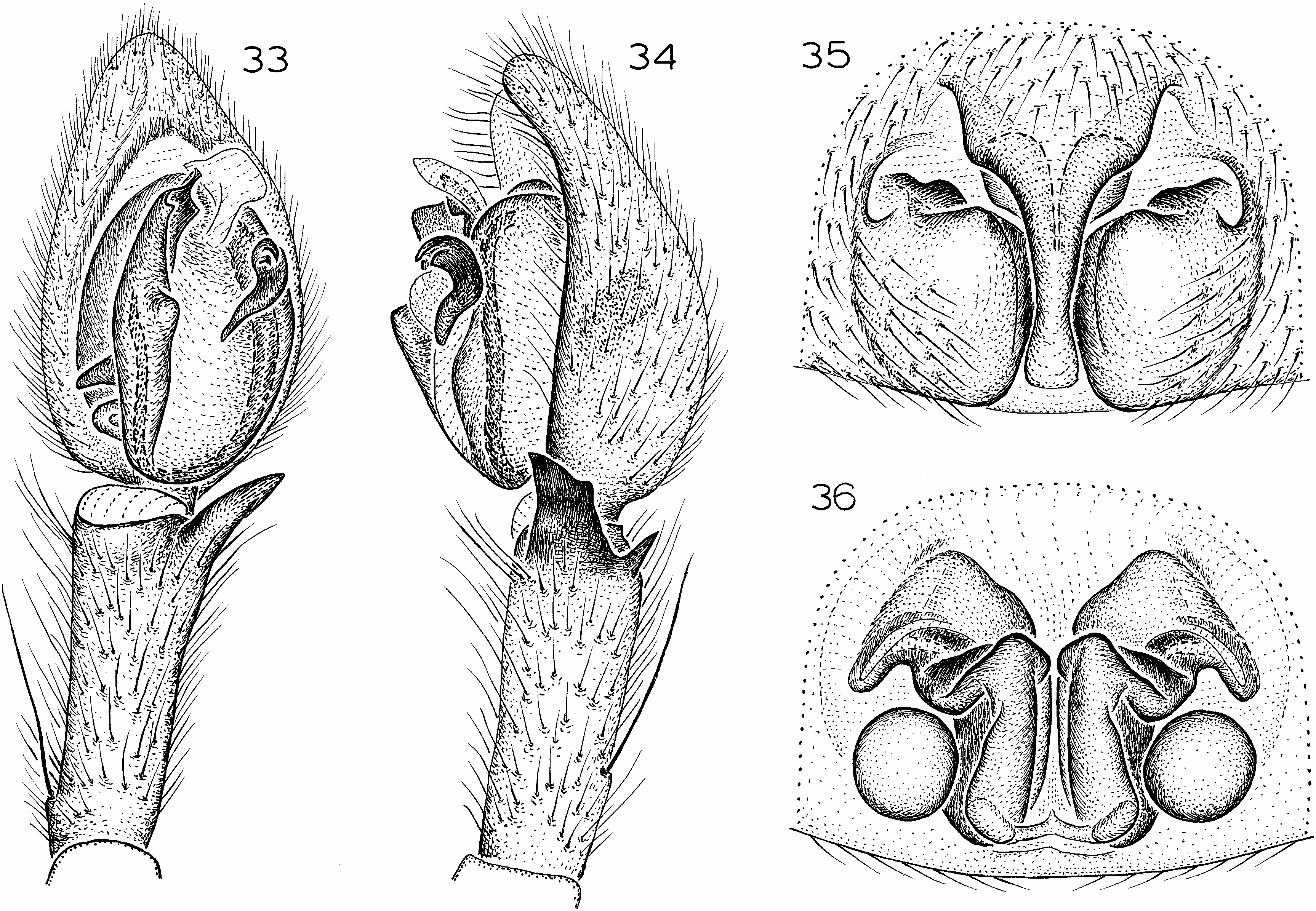
Figures 29–32 View Figs ; Map 1
TYPES: Male holotype and female allotype from Titus Canyon Cave , Death Valley National Monument , Inyo Co., California (Jan. 22, 1972; A. Jung), deposited in AMNH .
ETYMOLOGY: The specific name is a patronym in honor of the collector of the types.
DIAGNOSIS: Males of this longlegged, cavernicole species resemble those of A. aalbui in having a narrow, erect embolus (fig. 29), but have a much narrower ventral prong of the retrolateral tibial apophysis (fig. 30); females also resemble those of A. aalbui in having very short anterolateral epigynal margins, but have the epigynal septum widened at the level of the anterolateral epigynal margins (fig. 31).
MALE: Total length 8.9. Color paler than in A. sober , with carapace brownish orange, legs with femora light yellow, grading to brownish orange on more distal segments, abdomen pale white. Leg spination: femora: I p021; II p221; IV r012; tibiae: I, II d1 01, v642, r100; IV r101; metatarsi: I, II p110, r110; III p122; IV v222. Tegulum not widened opposite median apophysis, embolus relatively narrow, erect (fig. 29); dorsal prong of retrolateral tibial apophysis relatively large for genus, ventral prong relatively narrow (fig. 30).
FEMALE: Total length 13.6. Coloration as in male. Leg spination: femora: I p031; II p221; III r211; IV p212, r012; tibiae: I, II v462, r010; metatarsi: III p122; IV r112. Anterolateral epigynal margins and atrium relatively short, septum widened at that level (fig. 31), median epigynal ducts massive (fig. 32).
terolateral epigynal margins, but have the epigynal septum widest anteriorly, rather than at the level of the anterolateral epigynal margins (fig. 35).
MALE: Total length 9.2. Coloration as in A. jungi . Leg spination (both legs I missing): femora: II p221; IV r002; tibiae II d10 1, v462, r010; metatarsi: II p200, r10 0; III p122, r122; IV r112. Tegulum not widened opposite median apophysis, embolus relatively narrow, erect (fig. 33); dorsal prong of retrolateral tibial apophysis relatively large for genus, ventral prong relatively wide, especially at base (fig. 34).
FEMALE: Total length 12.3. Coloration as in A. jungi . Leg spination: femora: I p031; II p221; III r211; IV r002; tibiae I, II v462, r010; metatarsi: I, II p200, r20 0; III p122; IV p122, r112. Anterolateral epigynal margins and atrium relatively short, septum widened anteriorly (fig. 35), median epigynal ducts massive (fig. 36).
OTHER MATERIAL EXAMINED: CALIFORNIA: San Bernardino Co.: Medicine Cave , Providence
OTHER MATERIAL EXAMINED: CALIFORNIA: Inyo Co.: Defense Cave, Stone Canyon , Argus Range , Sept. 7, 1988, elev. 4000 ft ( R. Aalbu, CAS), 1/; Titus Canyon Cave , Death Valley National Monument, Jan. 22, 1972 (A. Jung, AMNH) , 1?.
DISTRIBUTION: Known only from caves in
Inyo Co., California (map 1) .
Anachemmis aalbui , new species
Figures 33–36 View Figs ; Map 1
TYPE: Male holotype taken in pitfall trap at an elevation of 4300 ft at the Park Headquarters, Mitchell Caverns State Park , San Bernardino Co., California (Mar. 17–June 16, 1979; R. Aalbu), deposited in CAS .
ETYMOLOGY: The specific name is a patronym in honor of the collector of the types.
DIAGNOSIS: Males of this longlegged species resemble those of A. jungi in having a narrow, erect embolus (fig. 33), but have a wider ventral prong of the retrolateral tibial apophysis (fig. 34); females also resemble those of A. jungi in having very short an
Chart 3. Seasonal abundance of Anachemmis linsdalei based upon the specimens collected (450) from 10 pitfall traps maintained at Arroyo Seco, Monterey County , California. Yaxis 5 number of specimens; Xaxis 5 time; solid lines 5 females; dashed lines 5 males.
Mountains State Recreation Area , June 20–Sept. 27, 1988, pitfall ( R. Aalbu, CAS), 6 /.
DISTRIBUTION: Known only from San Bernardino Co., California (map 1) .
Anachemmis beattyi , new species
Figures 37–40 View Figs ; Map 1
TYPE: Male holotype from Peppersauce Cave Canyon (north side of Santa Catalina Mountains ), Pinal Co., Arizona (Apr. 21, 1961; J. Beatty), deposited in AMNH .
ETYMOLOGY: The specific name is a patronym in honor of the collector of the types.
DIAGNOSIS: Males of this distinctive species can be recognized by the distally long and narrowed embolus (fig. 37), females by the anteriorly very wide epigynal septum bearing deep, paramedian invaginations (fig. 39).
MALE: Total length 8.4. Coloration as in A. jungi . Leg spination: femora: I p031, r2 12; II p211; IV r012; tibiae: I d101, v4 62, r110; II d101, v462, r100; metatarsi: I r100; II p010, r110. Tegulum not widened opposite median apophysis, embolus narrowed distally (fig. 37); dorsal prong of retrolateral tibial apophysis reduced to tiny point, ventral prong relatively narrow (fig. 38).
FEMALE: Total length 8.8. Coloration as in A. jungi . Leg spination: femora: I p021, r1 11; IV p201, r002; patellae: III p000, r000; IV p000; tibiae I, II v462, r010; metatarsi III p122. Anterolateral epigynal margins and atrium relatively short, septum much widened at that level, bearing deep paramedian invaginations (fig. 39), median epigynal ducts massive (fig. 40).
OTHER MATERIAL EXAMINED: ARIZONA: Coconino Co.: Manzanita Camp, Oak Creek Canyon , July 25, 1952 (M. Cazier, AMNH) , 2/. Graham Co.: Lower Canyon, Mount Graham , July 14, 1956 (W. Gertsch, V. Roth, AMNH), 1/. MEXICO : SONORA: Cajon Bonito , 318189N, 1088559W, Sept. 11, 1973 ( V. Roth, CAS), 3 /.
DISTRIBUTION: Known only from Arizona and Sonora (map 1).


| R |
Departamento de Geologia, Universidad de Chile |
| AMNH |
American Museum of Natural History |
| UCR |
University of California |
| MCZ |
Museum of Comparative Zoology |
| V |
Royal British Columbia Museum - Herbarium |
| LACM |
Natural History Museum of Los Angeles County |
| T |
Tavera, Department of Geology and Geophysics |
| UCB |
University of California at Berkeley |
| CAS |
California Academy of Sciences |
No known copyright restrictions apply. See Agosti, D., Egloff, W., 2009. Taxonomic information exchange and copyright: the Plazi approach. BMC Research Notes 2009, 2:53 for further explanation.
|
Kingdom |
|
|
Phylum |
|
|
Class |
|
|
Order |
|
|
Family |
Anachemmis
| PLATNICK, NORMAN I. & UBICK, DARRELL 2005 |
Anachemmis scaber
| Roewer, C. F. 1955: 607 |
Anachemmis Chamberlin, 1919: 12
| Chamberlin, R. V. 1919: 12 |
Anachemmis sober
| Silva 2003: 41 |
| Chamberlin, R. V. 1919: 13 |