
Lindholmiola lens (A. FéRUSSAC, 1832)
|
publication ID |
https://doi.org/ 10.5169/seals-787037 |
|
DOI |
https://doi.org/10.5281/zenodo.5843621 |
|
persistent identifier |
https://treatment.plazi.org/id/038C1808-EF58-FFF6-59A5-FBB14D768F8D |
|
treatment provided by |
Carolina |
|
scientific name |
Lindholmiola lens (A. FéRUSSAC, 1832) |
| status |
|
Lindholmiola lens (A. FéRUSSAC, 1832) View in CoL
Figs 3–6 View Figs 3–6 , 7–11 View Figs 7–11 , 12 View Figs 12–14. 12 , 15 View Fig
1821 Helix barbata A. FéRUSSAC , Tableaux systématiques des animaux mollusques classés en familles naturelles: 41 (Folio edition) or 37 (Quarto edition), Nr. 152 [partim].
1832 Helix lens A. FéRUSSAC (in A. Férussac & Deshayes), Histoire naturelle générale et particulière des mollusques terrestres et fluviatiles, (Atlas), 22–27: Taf. 66, F. 2 [Lectotype, design. Gittenberger & Groh 1986].
1832 Helix barbata , – Deshayes, Exped. Moree Moll., p. 162 (non barbata FéRUSSAC ).
1838 Helix lens , – Rossmässler, Iconographie der Land- & Süsswasser-Mollusken mit vorzüglicher Berücksichtigung der europäischen noch nicht abgebildeten Arten, (1) 2 (1/2): 10, Taf. 32, Fig. 450.
1846 Helix lens , – L. Pfeiffer, In: Martini & Chemnitz: Systematisches Conchylien-Cabinet, (1) 12 (II): 101, Taf. 13, Fig. 16–17 View Figs 16–18 .
1848 Helix lens , – L. Pfeiffer, Monographia heliceorum viventium, 1: 209.
1850 Helix lens , – Deshayes (in Férussac & Deshayes), Histoire naturelle générale et particulière des mollusques terrestres et fluviatiles, (Text), 1: 110 [partim, nec descr. et terr. typ.].
1853 Helix lens , – L. Pfeiffer, Monographia heliceorum viventium, 3: 162.
1854 Helix lens , – Reeve, Conchiologica Iconica, 7: species 1221.
1855 Helix lens , – Roth, Malakozoologische Blätter, 2: 30.
1859 Helix lens , – Mousson, Vierteljahrsschrift der Naturforschenden Gesellschaft in Zürich, 4: 258.
1859 Helix lentiformis MOUSSON , Vierteljahrsschrift der Naturforschenden Gesellschaft in Zürich, 4: 258. Locus typicus: " Thessalie et Attique ".
1859 Helix lens , – L. Pfeiffer, Monographia heliceorum viventium, 4: 187.
1868 Helix lens , – L. Pfeiffer, Monographia heliceorum viventium, 5: 260.
1868 Helix lentiformis , – L. Pfeiffer, Monographia heliceorum viventium, 5: 260.
1873 Helix barbata , – Martens, Malakozoologische Blätter, 20: 32.
1873 Helix lens , – Martens, Malakozoologische Blätter, 20: 32.
1874 Helix lens , – Martens, Malakozoologische Blätter, 21: 122.
1876 Helix lens , – L. Pfeiffer, Monographia heliceorum viventium, 7: 295.
1876 Helix lens , – Westerlund, Fauna der in der paläarctischen Region lebenden Binnenconchylien, Prodromus, I: 40.
1876 Helix lens var. aliostoma WESTERLUND , Fauna der in der paläarctischen Region lebenden Binnenconchylien, Prodromus, I: 41.
1876 Helix lens var. lentiformis , – Westerlund, Fauna der in der paläarctischen Region lebenden Binnenconchylien, Prodromus, I: 41.
1877 Helix lens , – L. Pfeiffer, Monographia heliceorum viventium, 8: 576.
1879 Helix (Trigonostoma) lens , – Westerlund & Blanc, Aperçu sur la faune malacologique de la Grèce inclus l’Epire et la Thessalie: 34.
1879 Helix (Trigonostoma) lens var. lentiformis , – Westerlund & Blanc, Aperçu sur la faune malacologique de la Grèce inclus l’Epire et la Thessalie: 35.
1879 Helix (Trigonostoma) lens var. piligera WESTERLUND & BLANC , Aperçu sur la faune malacologique de la Grèce inclus l’Epire et la Thessalie: 36. Taf. 1, Fig. 10 View Figs 7–11 .
1879 Helix (Trigonostoma) lens var. callojuncta WESTERLUND & BLANC , Aperçu sur la faune malacologique de la Grèce inclus l’Epire et la Thessalie: 36. Taf. 2, Fig. 11 View Figs 7–11 .
1882 Helix lens , – Hesse, Jahrbücher der Deutschen Malakozoologischen Gesellschaft, 9: 320.
1882 Helix lens var. lentiformis , – Hesse, Jahrbücher der Deutschen Malakozoologischen Gesellschaft, 9: 320.
1883 Helix (Anchistoma) lens , – O. Boettger, Jahrbücher der Deutschen Malakozoologischen Gesellschaft, 10: 323.
1883 Helix (Anchistoma) lens var. elia O. BOETTGER , Jahrbücher der Deutschen Malakozoologischen Gesellschaft, 10: 330.
1884 Helix lens , – Hesse, Jahrbücher der Deutschen Malakozoologischen Gesellschaft, 11: 233, Taf. 4, Fig. 5 View Figs 3–6 , Fig. 5 a View Figs 3–6 .
1885 Helix (Gonostoma) lens var. piligera , – O. Boettger, in Stussiner & O. Boettger, Jahrbücher der Deutschen Malakozoologischen Gesellschaft, 12: 165.
1885 Helix (Gonostoma) lens var. lentiformis , – O. Boettger, in Stussiner & O. Boettger, Jahrbücher der Deutschen Malakozoologischen Gesellschaft, 12: 165.
1887 Helix (Caracolina) lens , – Tryon, Manual of Conchology, 3: 119.
1887 Helix (Caracolina) lens var. lentiformis , – Tryon, Manual of Conchology, 3: 119.
1887 Helix (Caracolina) lens var. piligera , – Tryon, Manual of Conchology, 3: 119.
1887 Helix (Caracolina) lens var. callojuncta , – Tryon, Manual of Conchology, 3: 119.
1887 Helix (Caracolina) lens var. aliostoma , – Tryon, Manual of Conchology, 3: 119.
1889 Helix (Caracollina) lens , – Martens, Archiv für Naturgeschichte, 55 (1): 172.
1889 Helix (Gonostoma) lens var. lentiformis , – Martens, Archiv für Naturgeschichte, 55 (1): 173.
1889 Helix (Caracolina) lens , – Westerlund, Fauna der in der paläarctischen Region lebenden Binnenconchylien, 2: 22.
1889 Helix (Caracolina) lens var. lentiformis , – Westerlund, Fauna der in der paläarctischen Region lebenden Binnenconchylien, 2: 22.
1889 Helix (Caracolina) lens var. piligera , – Westerlund, Fauna der in der paläarctischen Region lebenden Binnenconchylien, 2: 23.
1889 Helix (Caracolina) lens var. callojuncta , – Westerlund, Fauna der in der paläarctischen Region lebenden Binnenconchylien, 2: 23.
1889 Helix (Caracolina) lens var. elia , – Westerlund, Fauna der in der paläarctischen Region lebenden Binnenconchylien, 2: 23.
1891 Helix (Gonostoma) lens var. callojuncta , – O. Boettger, Nachrichtsblatt der Deutschen Malakozoologischen Gesellschaft, 23 (5/6): 83.
1892 Helix lens , – Schuberth, Archiv für Naturgeschichte, 58 (1): 8, Taf. 1 Fig. 6 View Figs 3–6 .
1892 Helix lens var. lentiformis , – Schuberth, Archiv für Naturgeschichte, 58 (1): 8, Taf. 1, Fig. 7–8 View Figs 7–11 .
1894 Helix (Caracollina) lens , – Pilsbry, Manual of Conchology, 9: 288.
1894 Helix (Caracollina) lens var. lentiformis , – Pilsbry, Manual of Conchology, 9: 288.
1894 Helix (Caracollina) lens var. piligera , – Pilsbry, Manual of Conchology, 9: 288.
1894 Helix (Caracollina) lens var. callojuncta , – Pilsbry, Manual of Conchology, 9: 288.
1894 Helix (Caracollina) lens var. aliostoma , – Pilsbry, Manual of Conchology, 9: 288.
1894 Helix (Caracollina) lens var. elia , – Pilsbry, Manual of Conchology, 9: 288.
1894 Helix (Anchistoma) lens , – O. Boettger, Nachrichtsblatt der Deutschen Malakozoologischen Gesellschaft, 26 (1–2): 2.
1902 Helix (Gonostoma) lens , – Sturany, Denkschriften der Kaiserlichen Akademie der Wissenschaften in Wien, Mathematisch-Naturwissenschaftliche Klasse Wien, 52: 403.
1902 Helix (Gonostoma) barbata , – Sturany, Denkschriften der Kaiserlichen Akademie der Wissenschaften in Wien, Mathematisch-Naturwissenschaftliche Klasse Wien, 52: 403 (non barbata FéRUSSAC ).
1918 Caracollina lens , – Hesse, Nachrichtsblatt der Deutschen Malakozoologischen Gesellschaft, 50: 109.
1918 Caracollina lens lentiformis , – Hesse, Nachrichtsblatt der Deutschen Malakozoologischen Gesellschaft, 50: 109.
1918 Caracollina lens aliostoma , – Hesse, Nachrichtsblatt der Deutschen Malakozoologischen Gesellschaft, 50: 109.
1918 Caracollina lens piligera , – Hesse, Nachrichtsblatt der Deutschen Malakozoologischen Gesellschaft, 50: 109.
1918 Caracollina lens callojuncta , – Hesse, Nachrichtsblatt der Deutschen Malakozoologischen Gesellschaft, 50: 109.
1918 Caracollina lens elia , – Hesse, Nachrichtsblatt der Deutschen Malakozoologischen Gesellschaft, 50: 109.
1928 Helicodonta lens , – Adensamer & Käufel, Sitzungsberichte der Akademie der Wissenschaften in Wien, Mathematisch-Naturwissenschaftliche Klasse, 137 (10): 793.
1928 Helicodonta lens piligera , – Adensamer & Käufel, Sitzungsberichte der Akademie der Wissenschaften in Wien, Mathematisch-Naturwissenschaftliche Klasse, 137 (10): 793.
1928 Helicodonta lens lentiformis , – Adensamer & Käufel, Sitzungsberichte der Akademie der Wissenschaften in Wien, Mathematisch-Naturwissenschaftliche Klasse, 137 (10): 793.
1929 Helicodonta (Caracollina) lens , – Gambetta, Archivio Zoologico Italiano, 13 (1/2): 51.
1930 Caracollina lens , – Käufel, Sitzungsberichte der Akademie der Wissenschaften in Wien, Mathematisch-Naturwissenschaftliche Klasse, 139: 184.
1931 Lindholmiola lens View in CoL , – Hesse, Zoologica, 31 (81) 1/2: 50.
1936 Lindholmiola lens View in CoL , – Fuchs & Käufel, Archiv für Naturgeschichte, N.F. 5 (4): 651. Fig. 77 [partim, not in the Angista canyon close to Drama]
1941 Lindholmiola (Helicodonta) lens lens View in CoL , – Käufel & Fuchs, Verhandlungen der Zoologisch-Botanischen Gesellschaft in Wien, 88/89: 201.
1960 Lindholmiola lens View in CoL , – Zilch, Euthyneura, p. 693, Abb. 2419.
1961 Lindholmiola lens View in CoL , – Jaeckel & Plate, Zoologische Abhandlungen, Abhandlungen and Berichte aus dem Staatlichen Museum für Tierkunde in Dresden, 26 (1): 3.
1962 Lindholmiola lens View in CoL , – Klemm, Sitzungsberichte der Österreichischen Akademie der Wissenschaften, Mathematisch-Naturwissenschaftliche Klasse, Abt. I, 171 (6/7): 252.
1976 Lindholmiola lens View in CoL , – Frank, Mitteilungen der Zoologischen Gesellschaft Braunau, 2 (9/11): 261.
1986 Lindholmiola lens View in CoL , – Gittenberger & Groh, Archiv für Molluskenkunde, 116 (4/6): 220. Abb. 1, a (= 2).
1986 Lindholmiola lens View in CoL , – Reischütz, Malakologische Abhandlungen aus dem Staatlichen Museum für Tierkunde Dresden, 11 (9): 94.
1990 Lindholmiola lens View in CoL , – Fechter & Falkner, Steinbachs Naturführer, p. 222 Abb. 1–3, 5.
1996 Lindholmiola lens View in CoL , – Welter-Schultes, Schriften zur Malakozoologie, 9: 22, 31.
1996 Lindholmiola lens View in CoL , – Dhora & Welter-Schultes, Schriften zur Malakozoologie, 9: 156, 190, Taf. 13, Fig. 167.
2002 Lindholmiola lens View in CoL , – Dhora, Studime mbi molusqet e Shqipërisë: 99: 193.
Diagnosis: shell flat, lower whorls with a blunt to sharp keel, umbilicus cylindrical to broadly perspective, penial lumen with two longitudinal pilasters.
Description of shell: shell almost flat, shell colour light brown to yellowish brown; protoconch whorls smooth; initial whorls of the teleoconch with fine radial stripes, developing to small riblets on the subsequent whorls, but decreasing in height on the last teleoconch whorls; on the subsurface, radial riblets weak to almost missing; sculpture of teleoconch of fine granules; below the suture a small stripe devoid of hairs, the remaining shell including the umbilicus covered by usually impermanent hairs (often only the periphery of the shell with hairs); hairs yellowish-brown, 0.56–0.75 mm long; 5½–7¾ regularly increasing whorls; lower whorls usually flattened with a blunt to sharp keel (sometimes the whorls are more rounded forming an inconspicuous keel); last whorl only slightly descending, then shortly bent towards the aperture; suture moderately deep; umbilicus shape variable, either initially cylindrical and rapidly increasing with the last whorl, or initially broadly perspective and regularly increasing, reaching a diameter of 1.6–3.9 mm; aperture oblique, in lateral view slightly to strongly bent; peristomial insertions 2.2–5.9 mm apart, connected by an inconspicuous callus (except in callojuncta); peristome sharp to blunt, sometimes slightly reflected; columellar peristomial callus weak, covering the umbilicus ca 10%.
Measurements: H: 3.6–7; D: 7.2–15.6; aH: 2–3.9 (3–6.1); aW: 3.4–7.8.
Details of body (n = 12 from 5 populations: 1 specimen from 2 km N of Neohóri/1; 4 specimens from the pass at Haniá; 1 specimen from E of Glifáda; 2 specimens from 3 km S of Ptéri; and 4 specimens between Olymbía and Kréstena): head and dorsum grey to brown, more bright at the flanks and the posterior body; foot sole cream, sometimes darker at the fringes; mantle on the last 1½ whorls with small irregular dots; dots are more elongate between lung vein and suture and larger than those on the lower side of the mantle; intensity of pigmentation increasing towards the mantle collar, pigments often fuse to a large brown spot on the last whorl; ureter opens 1.5– 1 mm before the respiratory pore.
Morphology of the genital organs: penis relatively short, moderately thickened, glandular tissue covering one third to half of the total of the penial tube; penial lumen filled by two longitudinal pilasters of equal length starting as thin threads on the distal end of the penis and ending in the proximal third of the penis with thickened tissue; sometimes a few small folds at the distal end of the penis parallel to the major pilasters; vagina moderately long, usually thickened; glandula with a short stem and a long distal part with deep crossing furrows; bursa copulatrix as long as or somewhat longer than the glandula, the pedunculus reaches ca 60% of the total length of the organ, usually well separated from the vesicle; atrium with a broad and flat pilaster starting at the genital pore, often subdivided by deep longitudinal furrows; vagina filled by a single sometimes broadened pilaster.
Differential diagnosis: Its sisterspecies seems to be L. spectabilis , which has a shell that is similar to the form callojuncta of L. lens . It differs from this form by its more slowly increasing and less perspective umbilicus. Generally, the shell surface in L. spectabilis is more coarsely granulated, hairs are almost missing (if present, then below the shell's periphery), its aperture is narrower but higher, its lower rim is more wavy and larger, and its peristomial insertions are closer. In the penial lumen, L. spectabilis shows three longitudinal pilasters (instead of two in L. lens ); according to Fechter & Falkner (1990: 222), its pre-mating behaviour is shorter, and the lack of several behavioural elements proved to establish a mating barrier.
Broader specimens of L. girva are similar to that form of L. lens , which inhabits the Island Évvia and the easternmost parts of continental Greece (= lentiformis ). However, the shell of L. girva is less flattened, it has more rounded and less shouldered whorls; its radial riblets are less regular, and its aperture is more strongly bent in lateral view; its penis is longer, but the glandular tissue is less developed; the penial lumen is filled with 2–3 pilasters which are not broadened at their proximal end.
Shells of L. barbata are usually more rounded with a blunt keel. Shells of the same size differ by having an additional whorl, and the umbilicus is almost completely covered by the peristomial columellar reflection (for more details refer to L. barbata ).
Type specimens: Greece, Ilía (= Elis), Koúmanis (= Kumani), UTM EG 68, 37.78°N 21.74°E, leg. Brenske, 1883, syntypes lens var. elia : SMF 101961/6 , 225646/1 , 225647/2 . — Etoloakarnanía, Náfpaktos (= Lèpante , Lepanto), UTM EH 74, 38.39°N 21.82°E, syntype lens var. callojuncta : NHMG 372 .
Additional specimens examined:
Greece, Makedonía, Vérmio Mountains , about 6 km from the highway Véria – Kozáni direction Séli (= Áno Vérmio), conglomerate rocks at river bed, 530 m alt., UTM EK 98 , 40 .4971°N 22.1253°E, leg. Fauer & Subai 24.09.1989, S 15686 View Materials /1 ; gorge 2 km N of Neohóri (= NE of Aridéa ), on limestone rocks, 250 m alt., UTM EL 94 , 41 .0475°N 22.0916°E, leg. Subai 09.05.1995, S 15922 View Materials /13 + 1 (alk.) ; leg. Subai & Szekeres, 19.5.1997, S 15923 View Materials /5 ; 8.5 km NNE of Aridéa, on limestone rocks 3 roadkm. N of Vorinó , 250 m alt., UTM EL 94 , 41 .06°N 22.09°E, leg. Gittenberger & Uit de Weerd GoogleMaps 9.5.2000, NNM/6 View Materials ; 9 km NNE of Aridéa, isolated rocks 6.3 roadkm. N of Vorinó , 440 m alt., UTM EL 94 , 41 .08°N 22.06°E, leg. Gittenberger & Uit de Weerd GoogleMaps 9.5.2000, NNM/2 View Materials + 1 (juv.) ; in Véria, on loess wall beside the rivulet, 135 m alt., UTM FK 08 , 40 .5260°N 22.1997°E, leg. Fauer & Subai 24.09.1989, S 15925 View Materials /3 + 1 (juv.) ; forest in rocky gorge near Néa Pandeleimónas (= 18 km NW of Stómio), 100 m alt., UTM FK 32 , 40 .00°N 22.59°E, leg. Gittenberger & Uit de Weerd GoogleMaps 24.5.1999, NNM/1 View Materials (juv.) ; Halkidikí Peninsula, 500 m N of Eleohória , on low limestone rocks, 170 m alt., UTM FK 86 , 40 .3434°N 23.1613°E, leg. Subai 05.05.1995, S 15684 View Materials /11 ; Halkidikí Peninsula, in valley beside the cave of Petrálona , 360 m alt., UTM FK 87 , 40 .3759°N 23.1681°E, leg. Subai 05.05.1995, S 15924 View Materials /24 ; leg. Subai 29.5.1997, S 15682 View Materials /2 ; rocky mountain slope 11.5 km ESE of Aridéa, NE border of Theodorákio , 450 m alt., UTM FL 03 , 40 .95°N 22.19°E, leg. Gittenberger & Uit de Weerd 10.5.2000, NNM/2 View Materials ; 500 m W of Gríva (= WSW of Axioúpoli ), on limestone rocks, 540 m alt., UTM FL 13 , 40 .9562°N 22.4009°E, leg. Subai & Szekeres 20.05.1997, S 15683 View Materials /4 ; N border of Asvestohóri (= E of Thessaloníki), on dry limestone rocks, 400 m alt., UTM FL 70 , 40 .6466°N 23.0236°E, leg. Subai & Szekeres 8.05.1997, S 15688 View Materials /1 ; between Rizá and Paleohóra (= 12.5 km W of Arnéa), 500 m alt., UTM GK 08 , 40 .50°N 23.44°E, leg. Gittenberger & Uit de Weerd GoogleMaps 22.5.1999, NNM/1 View Materials (juv.) ; Kassándra Peninsula, limestone rocks near Loutrá, near sea, 20–25 m alt., UTM GK 22 , 39 .9235°N 23.5915°E, leg. Subai 05.05.1995, S 15681 View Materials /66 ; Sithonía Peninsula, mountain at S border of Porto Koufós , on limestone rocks in quarry, 30 m alt., UTM GK 42 , 39 .9576°N 23.9263°E, leg. Subai 06.05.1995, S 15631 View Materials /1 ; Sithonía Peninsula , mountain 1.5 km S of Porto Koufós, 10 m alt., UTM GK 42 , 39 .9494°N 23.9348°E, leg. Subai 05.05.1995, S 15629 View Materials /110. — Thessalía, E border of Theópetra (= 6 km SE of Kalambáka ), surrounding of church, UTM EJ 59 , 39 .67°N 21.68°E, leg. Fauer 21.8.1982, Maa /7, S 12218 View Materials /5 ; Theópetra (= Kuvelci GoogleMaps , 6 km SSE of Kalambáka), on limestone blocks of rocks at river bank, 260 m alt., UTM EJ 59 , 39 .6798°N 21.6810°E, leg. E. & P. Subai 26.07.1975, S 3781/145, 3784/14 ; leg. Neuteboom 25.7.1979, NNM/2 View Materials ; leg. Gittenberger & Uit de Weerd 25.5.1999, NNM/16 View Materials + (alk.) ; Kalambáka, on conglomerate rocks beside the highway from Kalambáka to the Meteóra monasteries, 280 m alt., UTM EJ 59 , 39 .7103°N 21.6164°E, leg. Pintér, E. & P. Subai 29.07.1976, S 3785/5 ; N border of Morfovoúni , on E exposed limestone rocks, 840 m alt., UTM EJ 65 , 39 .3567°N 21.7464°E, leg. Subai & Szekeres 12.05.1997, S 15928 View Materials /2 + 1 (juv.) ; road border in Petrotó , 100 m alt., UTM EJ 87 , 39 .58°N 21.95°E, leg. Gittenberger & Uit de Weerd GoogleMaps 25.5.1999, NNM/4 View Materials ; W border of Petrotó, on low limestone rocks, 120 m alt., UTM EJ 88 , 39 .5840°N 21.9584°E, leg. Subai, 18.05.1995, S 15691 View Materials /1 (juv.) ; 10 km E of Kefalóvrisso , 250 m alt., UTM EK 81 , 39 .92°N 21.98°E, leg. Gittenberger & Uit de Weerd 25.5.1999, NNM/9 View Materials ; between Elassóna and Deskáti (= 9.5 km W of Elassóna), 250 m alt., UTM EK 91 , 39 .88°N 22.08°E, leg. Gittenberger & Uit de Weerd GoogleMaps 25.5.1999, NNM/2 View Materials ; 17 km W of Lárissa , bifurcation to Temkat, UTM FJ 08 , 39 .61°N 22.20°E, leg. Erőss 9.8.1993, S, 18258/1 ; between Tírnavos and Mesohóri GoogleMaps , 8 km along road SE of Tírnavos, 125 m alt., UTM FJ 09 , 39 .71°N 22.24°E, leg. Gittenberger & Uit de Weerd GoogleMaps 25.5.1999, NNM/19 View Materials + (alk.) ; road border 1 km W of Damássi , 150 m alt., UTM FJ 09 , 39 .71°N 22.16°E, leg. Gittenberger & Uit de Weerd GoogleMaps 25.5.1999, NNM/1 View Materials ; between Tírnavos and Damássi , crossing to Tríkala, on low limestone rocks, 120 m alt., UTM FJ 09 , 39 .6991°N 22.2134°E, leg. Pintér, E. & P. Subai 28.07.1976, HNHM 85641 View Materials /1, S 3782/16 ; 1 km E of Fársala , UTM FJ 15 , 39 .28°N 22.40°E, leg. Kiss & Pintér 8.7.1986, HNHM 29905 View Materials /6 ; 37.5 km SSE of Lárissa, on limestone rocks 3.5 roadkm. bevor Fársala, 200 m N of road Domokós – Lárissa , 425 m alt., UTM FJ 15 , 39 .28°N 22.32°E, leg. Gittenberger & Uit de Weerd GoogleMaps 21.5.2000, NNM/1 View Materials ; 2 km E of Fársala (= direction Ambelía), UTM FJ 25 , 39 .30°N 22.41°E, leg. Neuteboom 21.7.1979, NNM/2 View Materials ; Míra, N slope, on rocks, UTM FJ 25 , 39 .45°N 22.54°E, leg. Neuteboom 21.7.1979, NNM/1 View Materials ; Míra, path to Sofó, UTM FJ 36 , 39 .45°N 22.53°E, leg. Neuteboom 21.7.1979, NNM/12 View Materials ; 6 km SE of Almirós , W border of junction, 25 m alt., UTM FJ 53 , 39 .14°N 22.82°E, leg. Gittenberger & Uit de Weerd GoogleMaps 29.5.1999, NNM/24 View Materials ; 3 km S of Aerinó , W rim of highway, 150 m alt., UTM FJ 55 , 39 .30°N 22.74°E, leg. Gittenberger & Uit de Weerd GoogleMaps 29.5.1999, NNM/4 View Materials ; Néa Ionía (= Vólos, Volo), UTM FJ 65 , 39 .38°N 22.92°E, HNHM 39177 View Materials /3, SMF 101969 View Materials /5 ; leg. Stussiner, 1886, SMF 101964 View Materials /4 ; leg. C. R. Boettger, 1906, SMF 101978 View Materials /2 ; Néa Ionía , near of beach, UTM FJ 65 , 39 .34°N 22.92°E, leg. Schütt, 19.5.1962, SMF 279326 View Materials /7 ; road border 500 m E of Ahíllio (= Akhilion), 25 m alt., UTM FJ 71 , 39 .01°N 22.97°E, leg. Gittenberger & Uit de Weerd GoogleMaps 29.5.1999, NNM/12 View Materials ; surroundings of Agía Kiriakí Village (= 32 km SE of Néa Ionía), 50–100 m alt., UTM FJ 72 , 39 .09°N 23.07°E, leg. Gittenberger & Uit de Weerd GoogleMaps 28.5.1999, NNM/6 View Materials ; 1 km E of Agriá (= 5 km ESE of Néa Ionía ), 125 m alt., UTM FJ 75 , 39 .33°N 23.04°E, leg. Gittenberger & Uit de Weerd GoogleMaps 26.5.1999, NNM/9 View Materials ; SE border of Néa Ionia (= Volos) W of the freight harbor, on rocks, among weeds, UTM FJ 75 , 39 .3492°N 22.9768°E, leg. Subai 30.04.1991, S 15926 View Materials /11 ; Makrinítsa at Pílio [Mountains], UTM FJ 76 , 39 .40°N 22.98°E, leg. Stussiner, 1887, SMF 284934 View Materials /3, 284955/1 ; 500 m SSW of Makrinítsa , 275 m alt., UTM FJ 76 , 39 .39°N 22.97°E, leg. Gittenberger & Uit de Weerd GoogleMaps 27.5.1999, NNM/33 View Materials ; Pílio (= Pelion) [Mountains], UTM n. det., SMF 101870 View Materials /20 ; foot of Pílio [Mountains] (= Pílios), UTM n. det., leg. Stussiner, 1888, SMF 284933 View Materials /3 ; Pílio, 10 min. below peak, UTM FJ 76 , 39 .43°N 23.04°E, leg. Stussiner, 1888, SMF 284931 View Materials /4 ; Pílio, 1 hour below peak, UTM FJ 76 , 39 .42°N 23.05°E, leg. Stussiner, 1888, SMF 284932 View Materials /2 ; Survias monastery, N side of Pílio, UTM FJ 76 , 39 .4620°N 22.9847°E, leg. Stussiner, 1888, SMF 284935 View Materials /2 ; 4 km above Portaria (= direction Hánia), karst slope, 840 m alt., UTM FJ 76 , 39 .3704°N 23.0290°E, leg. Subai & Szekeres 9.05.1997, S 15929 View Materials /2 + 1 (juv.) + 1 (alk.) ; near Hánia (= ENE of Néa Ionia = Volos), in forest beside the Hotel "Hani Zisi", in leaf litter, 1150 m alt., UTM FJ 76 , 39 .3949°N 23.0619°E, leg. Subai & Szekeres 9.05.1997, S 15913 View Materials /2 (juv.) + 11 (alk.) ; road border at Kóttes (= 30.5 km SE of Néa Ionía), 70 m alt., UTM FJ 83 , 39 .11°N 23.09°E, leg. Gittenberger & Uit de Weerd GoogleMaps 28.5.1999, NNM/7 View Materials ; 4 km WSW of Marathéa (= 32 km SE of Néa Ionía), 15 m alt., UTM FJ 83 , 39 .11°N 23.12°E, leg. Gittenberger & Uit de Weerd GoogleMaps 28.5.1999, NNM/35 View Materials + 7 + (alk.) ; Olimbos (= Olympos) [Mountain], UTM n. det., leg. Maltzan, 1883, SMF 284954 View Materials /1 ; leg. Mahunka 15.9.1984, HNHM 23886 View Materials /14 + 8 (juv.) ; Témbi (= Tempe valley , approx. 30 km NE of Lárissa), on limestone rocks, UTM FK 31 , 39 .87°N 22.58°E, leg. Stussiner, 1884, SMF 284939 View Materials /4 ; Témbi (= Tempe valley , approx. 30 km NE of Lárissa), on limestone rocks and from the "Daphne" spring, UTM FK 31 , 39 .8796°N 22.5870°E, leg. Pintér, E. & P. Subai 28.07.1976, HNHM 39188 View Materials /12, S 3783/14 + 1 (juv.) ; leg. Neuteboom, 19.7.1979, NNM/2 View Materials + 3 ; leg. Maassen 7.1980, Maa /3 + 26 ; leg. Subai 24.7.1990, S 15927 View Materials /5 ; small valley along old road 500 m SW of Omólion (= Moli ), 50 m alt., UTM FK 31 , 39 .89°N 22.63°E, leg. Gittenberger & Uit de Weerd GoogleMaps 26.5.1999, NNM/1 View Materials ; Ossa Mountains , Profítis Ilías peak region, on marble rocks, 1550 m alt., UTM FK 40 , 39 .7948°N 22.6710°E, leg. Subai 23.07.1990, S 15930 View Materials /4 + 1 (juv.) ; Ossa Mountains, Bugari Valley , UTM n. det., leg. Stussiner, leg., SMF 284938 View Materials /2 ; Thessaloníki (= Saloniki), UTM n. det., leg. Haussknecht, 1885, SMF 284941 View Materials /1 ; Langadás near Thessaloníki , UTM FL 71 , 40 .74°N 23.06°E, SMF 207803 View Materials /9. — Fthiótida, plane between Brálos and Parnassós [Mountains], UTM FH 28, 38.69°N 22.45°E, leg. Pfeiffer, 1926, SMF 101876 View Materials /6 ; Brálos – Loutrá Thermopilón highway, 8 km from bifurcation Moni Damasta direction Loutrá Thermopilón , on rocks, 110 m alt., UTM FH 29 , 38 .8008°N 22.4973°E, leg. Subai 10.04.1986, S 15795 View Materials /1 ; entrance of gorge at SE border of Amfíklia , in the vicinity of a small chapel, on limestone rocks, 500 m alt., UTM FH 37 , 38 .6306°N 22.5963°E, leg. Subai 10.04.1986, S 15696 View Materials /2 ; Loutrá Thermopilón , monument, UTM FH 39 , 38 .79°N 22.53°E, leg. Kiss & Pintér 9.7.1986, HNHM 29917 View Materials /1 ; gorge W of Tithoréa and in the big cave, 850 m alt., UTM FH 47 , 38 .5702°N 22.6602°E, leg. Subai 11.04.1986, S 15694 View Materials /4 ; SW border of Atalánti , on limestone rocks, 190 m alt., UTM FH 77 , 38 .6534°N 22.9849°E, leg. Subai 11.04.1986, S 15695 View Materials /3 ; Atalánti (= Atalandi ), UTM FH 78 , 38 .65°N 22.99°E, SMF 284950 View Materials /4 ; leg. Thiesse, 1890, SMF 284897 View Materials /6, 284937/6 ; leg. Clessin, 1879, SMF 101859 View Materials /1 ; Ipáti, on limestone rocks beside the waterfall, 380 m alt., UTM FJ 00, 38.8710°N 22.2440°E, leg. Subai 16.05.1991, S 15711 View Materials /2 ; 1.5 km NE of Lamía (= highway direction Lárissa), stone mine beside Xerias river , on limestone rocks, 615 m alt., UTM FJ 20 , 38 .9673°N 22.3874°E, leg. Subai 10.04.1986, S 15697 View Materials /6 ; 9 km from Glífa direction Pelasgía , on limestone rocks, 100 m alt., UTM FJ 61 , 38 .9309°N 22.9229°E, leg. Subai 30.04.1991, S 15706 View Materials /19. — Etoloakarnanía, Veloútsa Mountain SE slope above Astakós , on limestone rocks, approx., 185 m alt., UTM EH 06 , 38 .5370°N 21.0692°E, leg. Subai, 19.05.1991, S 15715 View Materials /3 ; Messolóngi , UTM EH 34 , 38 .37°N 21.43°E, leg. Krüper, 1901, SMF 101866 View Materials /4 ; above Kefalóvrisso , on limestone rocks, 30 m alt., UTM EH 35 , 38 .4598°N 21.3670°E, leg. Fauer & Subai 30.09.1989, S 15736 View Materials /18 ; ruins of Ancient Kalydon (= 2 km from Evinos bridge direction Messolóngi ), under stones, UTM EH 44 , 38 .3725°N 21.5332°E, leg. Fauer & Subai 01.10.1989, S 15732 View Materials /42 ; Krionéri , on limestone rocks on Varássova Mountain, SW slope, 50–220 m alt., UTM EH 54 , 38 .3477°N 21.5973°E, leg. Fauer & Subai 01.10.1989, S 15731 View Materials /5 ; in Riza village, on limestone rocks and mountain slope W of Riza, beside the old road to Messolóngi , 70 m alt., UTM EH 64 , 38 .3541°N 21.6978°E, leg. Fauer & Subai 02.10.1989, S 15735 View Materials /13 ; Náfpaktos (= Lepanto ), UTM EH 74 , 38 .39°N 21.82°E, SMF 285762 View Materials /7 ; leg. Krüper SMF 101895 View Materials /23, 101898/6 ; leg. Thiesse, 1890, SMF 284956 View Materials /6 ; on limestone rocks in Náfpaktos, 20 m alt., UTM EH 74 , 38 .3929°N 21.8259°E, leg. Pintér, E. & P. Subai 31.07.1976, HNHM 39184 View Materials /2 + 3 (juv.), S 3799/3. — Fokída, mountain W of Glifáda (= opposite of Trizónia Island ), on limestone rocks, 100 m alt., UTM EH 94 , 38 .3883°N 22.0711°E, leg. Subai 14.04.1986, S 15720 View Materials /5 ; leg. Kiss & Pintér 23.7.1986, HNHM 29900 View Materials /8 + 6 (juv.) ; leg. Riedel & Subai 15.4.1988, S 15739 View Materials /36 ; border of Ágios Spirído Village (= E of Glifáda), on dry limestone rocks, 30 m alt., UTM EH 94 , 38 .3679°N 22.1169°E, leg. Fauer & Subai 01.10.1989, S 15734 View Materials /16 ; 6 km from Erátini direction Náfpaktos , on rocks at sea shore, 40 m alt., UTM FH 04 , 38 .3316°N 22.1907°E, leg. Subai 14.04.1986, S 15723 View Materials /5 ; 4 km S of Malandrino (= S of Lidoríki ), on limestone rocks, 550 m alt., UTM FH 05 , 38 .4178°N 22.2498°E, leg. Subai 13.4.1986, S 15730 View Materials /7 ; approx. 200 m from the crossing Lidoríki–Erátini–Amfissa direction Amfissa , on limestone rocks, 640 m alt., UTM FH 15 , 38 .4052°N 22.2550°E, leg. Fauer & Subai 01.10.1989, S 15733 View Materials /8 ; 9 km from Mórnou dam direction Lévka, W side of a peninsula on S banks of the dam reservoir, on limestone rocks, 550 m alt., UTM FH 06 , 38 .5342°N 22.1634°E, leg. Subai 13.04.1986, S 15729 View Materials /3 ; 3 km from Penteória direction Erátini , on limestone rocks, 750 m alt., UTM FH 15 , 38 .4155°N 22.2967°E, leg. Subai 14.04.1986, S 15722 View Materials /8 ; Lidorikíou Mountains, 28 km from Amfissa direction Lidoríki (= 19 km S of Lidoríki), 600 m alt., UTM FH 15 , 38 .3992°N 22.2696°E, leg. Subai 13.04.1986, S 15728 View Materials /2 ; 7.5 km from Itéa direction Galaxídi , UTM FH 25 , 38 .42°N 22.39°E, leg. Neuteboom 22.7.1979, NNM/8 View Materials + 1 (juv.) ; 2 km S of Ámfissa (= direction Vouníhora), on limestone rocks, 300 m alt., UTM FH 26 , 38 .5087°N 22.3821°E, leg. Subai 16.05.1991, S 15718 View Materials /16 ; Eptálofos (= Agóriani), Parnassós Mountains , UTM FH 27 , 38 .59°N 22.49°E, SMF 284867 View Materials /3 ; leg. Krüper, 1888, SMF 101984 View Materials /4 ; leg. Krüper, 1899 and, 1901, SMF 101923 View Materials /8 ; leg. Schlüter, 1888, SMF 284864 View Materials /1 ; 2.5 km of Graviá direction Amfissa , on limestone rocks, 540 m alt., UTM FH 27 , 38 .6607°N 22.4253°E, leg. Subai 12.04.1986, S 15737 View Materials /4 ; E-exponated rocks at S border of Marioláda , 450 m alt., UTM FH 27 , 38 .65°N 22.46°E, leg. Gittenberger & Uit de Weerd GoogleMaps , 19.5.2000, NNM/18 View Materials ; 2 km SE von Marioláda , an Kalkfelsen, 780 m alt., UTM FH 27 , leg. Gittenberger & Uit de Weerd , 19.5.2000, NNM/5 View Materials ; E border of Desfína, UTM FH 35 , 38 .41°N 22.53°E, leg. Hoenselaar 27.5.1996, Maa /2 ; NE of Delfí, ruins of ancient Delphi GoogleMaps , 650 m alt., UTM FH 36 , 38 .4824°N 22.4981°E, SMF 207815 View Materials /9 ; leg. Müller, SMF 285174 View Materials /1 ; leg. Krüper, SMF 101896 View Materials /7 ; leg. Pfeiffer, 1926, SMF 101892 View Materials /3, 101893/10, 101894/1 ; leg. Schütt 4.6.1969, S 3798/3 ; leg. Neuteboom 22.7.1979, NNM/7 View Materials + 3 (juv.) ; leg. Drimmer 23.5.1982, HNHM 33703 View Materials /5 ; leg. Podani 30.7.1984, HNHM 21467 View Materials /3 ; leg. Neuteboom 26.10.1984, NNM/3 View Materials ; leg. Perjesi 29.4.1985, HNHM 23902 View Materials /1 ; leg. Kiss & Pintér 23.7.1986, HNHM 29895 View Materials /18 + 2 (juv.) ; leg. Sín 6.7.1987, HNHM 44341 View Materials /5 + 3 (juv.) ; leg. Erőss 6.4.1989, S, 18259/3 ; leg. Subai 16.5.1991, S 15719 View Materials /35 ; leg. Hoenselaar 26–27.5.1996, Maa /1 + 2 ; 2.5 km E of Amfíklia, UTM FH 37 , 38 .64°N 22.62°E, leg. Neuteboom 25.10.1984, NNM/1 View Materials + 2 (juv.) ; Polídrosos , UTM FH 37 , 38 .63°N 22.53°E, leg. Neuteboom 25.10.1984, NNM/1 View Materials ; Parnassós Mountains (= Parnass ), UTM n. det., SMF 101858 View Materials /7, 101882/1 ; leg. Krüper, 1883, SMF 101872 View Materials /3 ; leg. Schmidt, 1935, SMF 101878 View Materials /3 ; Parnassós Mountains , tree-line 1.7 km of ski-lift, UTM FH 46 , 38 .55°N 22.57°E, leg. Neuteboom 23.7.1979, NNM/2 View Materials + 3 (alk.). — Viotía, Tríodos, bifurcation after Dístomo , UTM FH 45 , 38 .44°N 22.68°E, leg. Neuteboom 23.7.1979, NNM / 25 km from the crossing Dístomo – Delfí–Livadiá direction Livadiá , on limestone rocks, 310 m alt., UTM FH 45 , 38 .4627°N 22.7161°E, leg. Subai 14.04.1986, S 15794 View Materials /1 ; Elikón Mountains, 6 km from Kiriáki direction Dístomo and 4 km southward on a small path, upper border of a gorge, on limestone rocks, 100 m alt., UTM FH 54 , 38 .3625°N 22.7208°E, leg. Subai 14.04.1986, S 15721 View Materials /1 ; 3 km from Paralía Sarandi direction Pródromos , on limestone rocks and in debris among rocks, 220 m alt., UTM FH 63 , 38 .2572°N 22.8756°E, leg. Subai 15.04.1986, S 15725 View Materials /14 ; 4.3 km from Paralía Sarandi direction Pródromos , on limestone rocks and in an olive tree plantation, 225 m alt., UTM FH 63 , 38 .2578°N 22.8826°E, leg. Subai 15.04.1986, S 15724 View Materials /5 ; rock gorge at SE border of Livadiá , on limestone rocks and in organic flotsam of creek, 220 m alt., UTM FH 65 , 38 .4329°N 22.8920°E, leg. Subai 15.04.1986, S 15796 View Materials /13 ; Lafísti (= Lofistion , E of Livadiá), on limestone rocks, 310 m alt., UTM FH 65 , 38 .4281°N 22.9189°E, leg. Subai 11.04.1986, S 15799 View Materials /3 ; Herónia , ancient theatre 6 km NW of Livadiá, 250 m alt., UTM FH 66 , 38 .49°N 22.84°E, leg. Gittenberger & Uit de Weerd GoogleMaps , 19.5.2000, NNM/1 View Materials ; 2 km E of Alíartos , on limestone rocks, approx. 80 m beside highway, 115 m alt., UTM FH 84 , 38 .4351°N 23.1997°E, leg. Riedel & Subai 09.04.1988, S 15761 View Materials /1 + 3 (juv.) ; 13 km W of Thíva, 9.9 roadkm. of Alíartos additional 2 km on a secondary road, 250 m alt., UTM FH 94 , 38 .33°N 23.14°E, leg. Gittenberger & Uit de Weerd GoogleMaps 20.5.2000, NNM/5 View Materials ; on limestone rocks beside the motor way, at the bifurcation to Akréfnio (= 5.5 km SE of the crossing near Kástro ), 120 m alt., UTM FH 95 , 38 .4500°N 23.2092°E, leg. Subai & Szekeres 11.05.1997, S 15813 View Materials /6 ; 7 km N of Thíva, on rocks 1 roadkm. along a secondary road to Movríki , UTM GH 05 , 38 .38°N 23.32°E, leg. Gittenberger & Uit de Weerd GoogleMaps 20.5.2000, NNM/2 View Materials + 1 (juv.) ; Skoponéri Village , about 50 m S of the tavern, on low limestone rocks, approx. 10 m alt., UTM GH 06 , 38 .5032°N 23.3549°E, leg. Subai & Szekeres 11.05.1997, S 15690 View Materials /47 + 2 (juv.) + 9 (alk.) ; above Skoponéri , E border of the village, on limestone rocks, 270 m alt., UTM GH 06 , 38 .5013°N 23.3675°E, leg. Subai & Szekeres 11.05.1997, S 15689 View Materials /8 + 1 (juv.) ; mountain slope 10 km from Halkída (= Chalkis) direction Thiva (= Thebe ), on limestone rocks, 270 m alt., UTM GH 25 , 38 .4282°N 23.5309°E, leg. Riedel & Subai 09.04.1988, S 15698 View Materials /7. — Atikí (= Attika), UTM n. det., SMF 284881 View Materials /7, 284893/2, 284894/1, 284980/3 ; leg. Krüper, 1883, SMF 101861 View Materials /8 ; approx. 8.5 km from Paralía Shínou direction Káto Alepohóri, on limestone rocks, approx. 10 m alt., UTM FH 81 , 38 .0514°N 23.0571°E, leg. Subai 14.05.1991, S 15712 View Materials /7 + 1 (juv.) ; Aigósthena (= Porto Germeno), on rocks below the castle ruins, 45 m alt., UTM FH 92 , 38 .1483°N 23.2321°E, leg. Subai 16.05.1991, S 15693 View Materials /2 (fragment) ; 11 km from the highway Vília–Aigósthena direction Kithairón peak, on limestone rocks, 1300 m alt., UTM FH 92 , 38 .1835°N 23.2583°E, leg. Subai 16.05.1991, S 15915 View Materials /7 + 1 (juv.) ; Vouliagméni (= opposite of Fléves Island ), on limestone rocks beside the highway, 20 m alt., UTM GG 48 , 37 .8086°N 23.7841°E, leg. Subai, 19.07.1979, S 15701 View Materials /51 ; 3.4 km SE of Varkíza (= coast road direction Agía Marína ), on limestone rocks, 30 m alt., UTM GG 48 , 37 .8127°N 23.8314°E, leg. Subai 07.05.1991, S 15705 View Materials /1 (fragment) ; "Varkíza Beach" camping near Varkíza , on limestone rocks, 30 m alt., UTM GG 48 , 37 .8226°N 23.8170°E, leg. Subai 20.07.1979, S 6644/10 ; 3 km from Vári direction Koropí , on limestone rocks, 50 m alt., UTM GG 49 , 37 .8415°N 23.8215°E, leg. Subai 20.07.1979, S 6700/2 ; coastal strip near Paleá Fókaia , UTM GG 57 , 37 .71°N 23.94°E, leg. Neuteboom 20.10.1984, NNM/1 View Materials ; 3 km N of Legrená , UTM GG 67 , 37 .69°N 24.00°E, leg. Neuteboom 20.10.1984, NNM/3 View Materials ; coast near Megara , UTM GH 00, 37.97°N 23.32°E, leg. Pfeiffer, 1926, SMF 101844 View Materials /1 ; Sborder of Megara , UTM GH 00, 37.97°N 23.35°E, leg. Kiss & Pintér, 19.7.1986, HNHM 29918 View Materials /2 + 1 (juv.) ; mountain slope at W border of Mégara , on limestone rocks, 65 m alt., 37.9962°N 23.3240°E, UTM GH 00, leg. Subai 07.07.1979, S 6515/2 + 2 (juv.) ; mountain slope beside Ágios Ierothéou monastery (= W of Mégara), 300 m alt., UTM GH 01 , 38 .093N, 23.2677°E, leg. Subai 07.07.1979, S 15702 View Materials /11 + 1 (juv.) ; 3.5 km from the highway Vília–Aigósthena direction Kithairón peak, rocks in coniferous forest, 850 m alt., UTM GH 02 , 38 .1706°N 23.2728°E, leg. Subai 16.05.1991, S 15692 View Materials /2 (fragment) ; Elefsína–Thíva country road, mountain behind Mándra , UTM GH 11 , 38 .08°N 23.48°E, leg. Pfeiffer, 1926, SMF 101875 View Materials /4 ; Pérama, on rocks at coastal strip direction Piráeus , UTM GH 20 , 37 .96°N 23.60°E, leg. Neuteboom 4.9.1982, NNM/1 View Materials ; Elefsína, dry mountain slope beside a quarry, 130 m alt., UTM GH 21 , 38 .0508°N 23.4950°E, leg. Subai 07.07.1979, S 6559/1 ; Athína (= Athen ), UTM n. det., SMF 284878 View Materials /9, 284879/2, 284946/2 ; leg. Krüper, 1883, SMF 101863 View Materials /5, 101972/11 ; leg. Heldreich, SMF 284882 View Materials /3 ; Piráeus, UTM GH 30 , 37 .94°N 23.63°E, leg. Krüper, 1883, SMF 101983 View Materials /3 ; Athína, Paleo Falíro (= Phaleron, part of Athína ), UTM GH 30 , 37 .92°N 23.70°E, leg. Krüper, SMF 101975 View Materials /39 ; Athína , Akropolis, UTM GH 30 , 37 .97°N 23.72°E, leg. Pfeiffer, 1926, SMF 101843 View Materials /24 ; Párnis Mountain (= Parnés) Chasia , UTM n. det., leg. Krüper, 1883, SMF 101971 View Materials /1 ; W side of Párnitha Mountain (= N of Athína), river valley along the circular path on top of the mountain, on limestone rocks, 1000 m alt., UTM GH 32 , 38 .1631°N 23.7020°E, leg. Subai 21.04.1988, S 15916 View Materials /13 ; SW border of Avlóna , on limestone rocks, 300 m alt., UTM GH 33 , 38 .2454°N 23.6855°E, leg. Subai 16.04.1986, S 15801 View Materials /2 ; leg. Riedel & Subai 9.4.1988, S 15804 View Materials /15 ; leg. Gittenberger & Uit de Weerd 20.5.2000, NNM/13 View Materials ; Likavittós (= Lykabettos) Mountain in Athína , on limestone rocks, UTM GH 40 , 37 .98°N 23.74°E, SMF 101874 View Materials /2, 285169/24, 285170/2 ; leg. Krüper, 1883, SMF 101860 View Materials /1 ; leg. Heldreich, SMF 284892 View Materials /3 ; leg. Coneménos, 1889, SMF 284886 View Materials /9 ; leg. Krüper, 1888, SMF 101985 View Materials /9 ; leg. Pintér 21.8.1976, HNHM 39181 View Materials /2 + 1 (juv.) ; leg. Perjesi 22.4.1985, HNHM 23890 View Materials /1 ; top of Likavittós Mountain in Athína , on limestone rocks, 250 m alt., UTM GH 40 , 37 .9826°N 23.7436°E, leg. Subai, 19.7.1979, S 6249/12 ; leg. Subai 22.04.1988, S 15704 View Materials /2 ; Hyméttos Mountain , UTM GH 40 , 37 .96°N 23.81°E, leg. Schmidt, SMF 285168 View Materials /2 ; leg. Köhler, SMF 285167 View Materials /2 ; leg. Knobbe, SMF 284885 View Materials /2 ; leg. Brenske, 1883, SMF 101963 View Materials /2, 284888/2 ; leg. Krüper, 1883, SMF 101862 View Materials /6 ; leg. Krüper, 1899, SMF 101967 View Materials /10 ; leg. Pfeiffer, 1926, SMF 101954 View Materials /1 ; N side of mount Hyméttos , on limestone rocks, approx. 800 m alt., UTM GH 40 , 37 .9604°N 23.8162°E, leg. Subai 4.4.1986, S 15713 View Materials /5 + 1 (juv.) 15714/100 + 3 (juv.) ; leg. Subai 21.4.1988, S 15710 View Materials /3 ; Kifissiá (= Kephissia ), UTM GH 41 , 38 .07°N 23.82°E, leg. Pfeiffer, 1926, SMF 101886/3 ; mountain SW of Anatolí (= W of Néa Mákri ), on limestone rocks, approx. 200 m alt., UTM GH 51 , 38 .0895°N 23.9468°E, leg. Subai 02.05.1991, S 15808 View Materials /14 ; Pendéli (= Pentelikon) [Mountains], UTM n. det., SMF 207814 View Materials /2 ; leg. Krüper, SMF 101974 View Materials /40 ; leg. Pfeiffer, 1926, SMF 101888 View Materials /1 ; Pendéli monastery, UTM GH 51 , 38 .05°N 23.86°E, leg. Pfeiffer, 1926, SMF 101887 View Materials /1 ; approx. 4 km NE of Pendéli, Pendéli (= Pentelikon) Mountains W side, on crystalline rocks, 700 m alt., UTM GH 51 , 38 .0653°N 23.9081°E, leg. Subai 02.05.1991, S 15809 View Materials /12 ; Soúnio , UTM KB 37 , 37 .65°N 24.02°E, leg. Pfeiffer, 1926, SMF 101885 View Materials /29 ; 4 km from Lavrio direction Markópoulo, on limestone rocks, 125 m alt., UTM KB 38 , 37 .7523°N 24.0260°E, leg. Subai 05.05.1991, S 15703 View Materials /15 ; road Athína–Soúnio , before Lavrio, UTM KB 48 , 37 .74°N 24.05°E, KB 38, leg. Pfeiffer, 1926, SMF 101884 View Materials /5 ; road Athína – Marathónas, UTM n. det., leg. Pfeiffer, 1926, SMF 101890 View Materials /9 ; road Athína – Soúnio, UTM n. det., leg. Pfeiffer, 1926, SMF 101883 View Materials /7. — Égina Island , UTM n. det., SMF 207811 View Materials /2 ; Mesagrós, Aphaia holy place, UTM GG 28 , 37 .75°N 23.53°E, leg. Erőss 5.4.1989, S, 18261/10. — Méthana Island GoogleMaps , Méthana Town, UTM GG 25 , 37 .58°N 23.39°E, leg. Haussknecht, 1885, SMF 284887 View Materials /2. — Kíthira Island (= Cerigo), "Keramoto", UTM n. det., leg. Krüper, 1893, SMF 101869 View Materials /8, 284913/2. — Kefaloniá Island , UTM n. det., HNHM 39171 View Materials /1, 39175/2, 39179/2, SMF 101857 View Materials /6, 101881/4, 84910/9, 284911/1 ; leg. Müller, SMF 285162 View Materials /2 ; Argostóli Peninsula, UTM DH 52 , 38 .18°N 20.48°E, leg. Visser 1.11.1985, NNM/1 View Materials (alk.). — Zakinthos Island (= Zante), UTM n. det., SMF 284884 View Materials /5 ; above Chiliomenon, UTM n. det., HNHM 39236 View Materials /3 + 1 (juv.). — Ilía (= Elis), theatre 15 km E of Gastoúni , UTM EG 39 , 37 .89°N 21.37°E, leg. Hoenselaar 17.4.1996, Maa GoogleMaps /5 ; Kaíafás (= NW of Zaháro), on limestone rocks and from the thermal well, UTM EG 55 , 37 .5193°N 21.6022°E, leg. Subai 07.04.1986, S 15798 View Materials /11 ; ruins of Arhea Olympia , 35 m alt., UTM EG 56 , 37 .6384°N 21.6307°E, HNHM, 18649/1; SMF 279327 View Materials /4, 284900/10, 285173/6 ; leg. Schlüter, SMF 284901 View Materials /15 ; leg. Pfeiffer, 1926, SMF 101851 View Materials /7 ; leg. Kühnel 4.1933, HNHM 9784 View Materials /2 ; leg. Hansen, 1937, HNHM 39187 View Materials /2 ; leg. Jaeckel, 1958, SMF 207816 View Materials /10 ; leg. Seidl 3.10.1965, NNM/4 View Materials ; leg. Guyat & Dawber 8.1973, HNHM 85645 View Materials /1, S 3793/12 ; leg. Pintér & Subai 2.8.1976, S 3494/61 ; leg. Sin 4–5.7.1985, HNHM 24029 View Materials /17 + 3 (juv.), 24069/25 + 4 (juv.) ; leg. Kiss & Pintér 23.7.1986, HNHM 29897 View Materials /9 + 3 (juv.) ; leg. Hoenselaar, 19.4.1996, Maa /7 ; between Arhea Olympia and Kréstena, beside the channel of Alfiós River, in grass and under stones, UTM EG 56 , 37 .6279°N 21.5923°E, leg. Subai 10.07.1979, S 15882 View Materials /36 + 17 (alk.) ; Giannitsohóri , Camping "Apollo", UTM EG 63, 37.39°N 21.69°E, leg. Hoenselaar 21–23.4.1996, Maa GoogleMaps /2 + 3 ; river gorge approx. 1.5 km E of Néa Figália, on limestone rocks, approx. 550 m alt., UTM EG 64 , 37 .4469°N 21.7890°E, leg. Riedel & Subai, 18.04.1988, S 15762 View Materials /1 ; road Tholon– Andrítsena , border of Lépreo, UTM EG 64 , 37 .43°N 21.72°E, leg. Hoenselaar 22.4.1996, Maa GoogleMaps /2 ; Koúmanis (= Kumani), UTM EG 68 , 37 .79°N 21.74°E, SMF 225648 View Materials /3 ; river gorge between the two bifurcations of the Lámbia – Tripótama highway to Orini , on limestone rocks, 630 m alt., UTM EG 79 , 37 .8608°N 21.8612°E, leg. Riedel & Subai 17.04.1988, S 15760 View Materials /9 ; leg. Hadjicharalambous & Subai 12.5.1991, S 15756 View Materials /1. — Ahaïa , 4.1 km from the crossing Kalávrita–Trípoli–Tripótama direction Tripótama, on limestone rocks, 1120 m alt., UTM EG 99 , 37 .8992°N 22.0087°E, leg. Hadjicharalambous & Subai 14.05.1991, S 15716 View Materials /5 ; dry meadow 2 km S of Klitoria (= direction Trípoli ), 500 m alt., UTM EG 99 , 37 .8808°N 22.1355°E, leg. Subai 09.07.1979, S 15738 View Materials /3 ; Araxos , on limestone rocks beside the stone mine at banks of Lake Kalogera, 20 m alt., UTM EH 32, 38.1642°N 21.4011°E, leg. Subai 07.04.1986, S 15727 View Materials /9 ; Skollis Mountain W slope above Sandoméri, on limestone rocks, in rock debris, 550 m alt., UTM EH 40 , 37 .9899°N 21.5781°E, leg. Riedel & Subai 16.04.1988, S 15766 View Materials /4 ; W slope of Skollis Mountain , NE of Sandoméri, on limestone rocks, 530 m alt., UTM EH 50 , 37 .9929°N 21.5778°E, leg. Subai 07.04.1986, S 15797 View Materials /9 ; Erímanthos Mountains above Kaléntzi, on limestone rocks, 1060 m alt., UTM EH 60 , 37 .9447°N 21.7650°E, leg. Hadjicharalambous & Subai 13.05.1991, S 15921 View Materials /4 ; Pátra (= Patras), UTM EH 63 , 38 .24°N 21.74°E, SMF 284890 View Materials /2, 284908/5, 284953/4 ; leg. Coneménos, SMF 101854 View Materials /5 ; leg. Brenske, 1883, SMF 101968 View Materials /6 ; leg. Krüper, 1895, SMF 284960 View Materials /6 ; leg. Krüper, 1899, SMF 101952 View Materials /11 ; leg. C. R. Boettger, 1905, SMF 101979 View Materials /5 ; Psathópirgos, UTM EH 74 , 38 .32°N 21.87°E, SMF 225650 View Materials /19 + 20 ; river valley near Psathopírgos, among dry plants and on rocks (no limestone!), 230 m alt., UTM EH 74 , 38 .3183°N 21.8823°E, leg. Subai 07.04.1986, S 15726 View Materials /5 ; in a dry river bed S of Flámpoura village (= Metohi ), 900 m alt., UTM EH 81 , 38 .0286°N 21.9965°E, leg. Pintér, E. & P. Subai 01.08.1976, S 3791/8, HNHM 39170 View Materials /5 ; bifurcation of the highway Kalávrita – Diakoftó to Rogí, Kerpiní, on limestone rocks, 700 m alt., UTM EH 91 , 38 .0534°N 22.1384°E, leg. Hadjicharalambous & Subai 13.05.1991, S 15717 View Materials /3 ; river gorge 3 km S from Ptéri , on limestone rocks and under stones, 1150 m alt., UTM EH 92 , 38 .1418°N 22.0710°E, leg. Riedel & Subai 15.04.1988, S 15920 View Materials /3 + 1 (juv.) + 2 (alk.) ; leg. Fauer & Subai 3.10.1989, S 15919 View Materials /9 ; leg. Hadjicharalambous & Subai 13.05.1991, S 15780 View Materials /1 ; in and around the cave N of Kastría , on limestone rocks, 840 m alt., UTM FH 00, 37.9603°N 22.1404°E, UTM FH 00, leg. Hadjicharalambous & Subai 14.05.1991, S 15778 View Materials /2 ; on rocks and on walls of Mega Spileo monastery (= N of Kalávrita), 950 m alt., UTM FH 01 , 38 .0884°N 22.1746°E, leg. Pintér, E. & P. Subai 01.08.1976, S 3792/3 ; Subai 9.7.1979, S 6577/1 ; in "Lemon Beach" camping near Paralia Akráta, under stones, UTM FH 12 , 38 .1653°N 22.3408°E, leg. Subai 09.07.1979, S/2 (alk.) ; Nezerá , UTM n. det., leg. Coneménos, SMF 225649 View Materials /2. — Korinthía, Killini Mountains , in spruce forest above Goúra, on limestone rocks, 1100 m alt., UTM FG, 19, 37.9347°N 22.3488°E, leg. Subai 08.07.1979, S 6428/1 + 2 (juv.) ; Killini Mountains , 7.5 km from Goúra direction Kastanéa, on limestone rocks, 800 m alt., UTM FG, 19, 37.8866°N 22.3408°E, leg. Subai 08.07.1979, S 6573/2 ; Oligirtos Mountains , 1 km from Kartéri direction Goúra, on limestone rocks and in cave crevices, 850 m alt., UTM FG 29 , 37 .8510°N 22.3996°E, leg. Subai 08.07.1979, S 15750 View Materials /2 ; Killini Mountains , mountain slope 6 km from Kaliáni direction Kiáto, on conglomerate rocks, 710 m alt., UTM FG 39 , 37 .9236°N 22.5262°E, leg. Subai 08.07.1979, S 6661/2 ; 1 km S of Neméa , on limestone rocks, 370 m alt., UTM FG 48 , 37 .8024°N 22.6670°E, leg. Hadjicharalambous & Subai 07.05.1991, S 15781 View Materials /2 ; ancient Neméa (= near Arhéa Neméa), UTM FG 58 , 38 .82°N 22.66°E, leg. Hoenselaar 22.5.1996, Maa GoogleMaps /5 ; 8.5 km from Ágios Vassílios direction Árgos, on limestone rocks, 290 m alt., UTM FG 58 , 37 .7779°N 22.7339°E, leg. Subai, 18.07.1979, S 6561/2 + 1(juv.) ; ruins of Arhea Kórinthos , 80 m alt., UTM FG 69 , 37 .9059°N 22.8792°E, SMF 284951 View Materials /6 ; leg. Brenske, 1883, SMF 284920 View Materials /1 ; leg. Krüper, SMF 101853 View Materials /5 ; leg. Pfeiffer, 1926, SMF 101845 View Materials /6 ; leg. Pintér & Subai 6.08.1976, HNHM 39172 View Materials /4, S 3795/4 ; leg. Nosek 3.10.1976, HNHM 21461 View Materials /2 ; leg. Hoenselaar 23.5.1996, Maa /2 ; road to Akrokorinthos, UTM FG 69 , 37 .89°N 22.87°E, leg. Pfeiffer, 1926, SMF 101846 View Materials /1 + 4 (juv.) ; leg. Neuteboom 29.8.1982, NNM/1 View Materials ; ruins of the old castle of Akrokorinthos, 400 m alt., UTM FG 69 , 37 .8900°N 22.8690°E, SMF 285172 View Materials /2 ; leg. Schlüter 27.4.1912, SMF 285765 View Materials /8 ; Tomlin, 1904, SMF 284889 View Materials /1 ; leg. Subai, 18.7.1979, S 15744 View Materials /57 + 1 (alk.) ; leg. Kiss & Pintér 21.8.1988, HNHM 44600 View Materials /24 +, 18 (juv.) ; leg. Neuteboom 29.8.1982, NNM/11 View Materials + 3 (juv.) ; highway Epidauros – Kórinthos, 8 km from the bifurcation to Sofikó direction Epidauros, 230 m alt., UTM FG 87 , 37 .7334°N 23.1010°E, leg. Pintér, E. & P. Subai 06.08.1976, HNHM 39182 View Materials /2 + 1 (juv.), S 3796/2 ; Kórfos , UTM FG 88 , 37 .76°N 23.12°E, leg. Kiss & Pintér 16.8.1988, HNHM 85644 View Materials /7 ; 2 km S of Kórfos , UTM FG 88 , 37 .73°N 23.12°E, leg. Kiss & Pintér, 19.7.1986, HNHM 29909 View Materials /1 (juv.) ; N exposed lime hill slope between Ano Loutró and Kariá, 550 m alt., UTM FH 31 , 38 .0842°N 22.5403°E, leg. Fauer & Subai 03.10.1989, S 15740 View Materials /1 ; ruins of Heraion and on limestone rocks beside Lake Heraiou , 60 m alt., UTM FH 61 , 38 .0349°N 22.8708°E, leg. Subai, 18.07.1979, S 6352/13 + 3 (alk.) ; Loutráki, UTM FH 70 , 37 .98°N 22.97°E, leg. Krüper, SMF 101973 View Materials /10 ; leg. Butot & Subai, 19.2.1981, S 17540 View Materials /12 + 3 (alk.) ; leg. Kiss & Pintér, 19.7.1986, HNHM 29901 View Materials /18 + 7 (juv.) ; leg. Erőss 22.7.1992, S, 18257/1 ; dry mountain slope at NW border of Loutráki, on limestone rocks, 80 m alt., UTM FH 70 , 37 .9836°N 22.9715°E, leg. Subai 07.07.1979, S 15751 View Materials /15 ; W border of Perahóra , UTM FH 71 , 38 .02°N 22.94°E, leg. Kiss & Pintér 16.8.1988, HNHM 44685 View Materials /15 + 6 (juv.) ; 1 km S of Perahóra , UTM FH 71 , 38 .01°N 22.94°E, leg. Kiss & Pintér 16.8.1988, HNHM 44589 View Materials /6 + 1 (juv.) ; approx. 1.5 km from Paralía Shínou direction Káto Alepohóri, on limestone rocks, approx. 100 m alt., UTM FH 81 , 38 .0570°N 23.0055°E, leg. Subai 14.05.1991, S 15914 View Materials /10. — Arkadía, 1 km from Stavrodrómio direction Arhea Olympia (= highway Arhea Olympia–Trípoli), 630 m alt., UTM EG 87 , 37 .6989°N 21.9392°E, leg. Pintér, E. & P. Subai 02.08.1976, S 3775/10 ; 2 km from Langádia direction Arhea Olympia (= highway Arhea Olympia–Trípoli), 850 m alt., UTM EG 87 , 37 .6815°N 22.0147°E, leg. Pintér, E. & P. Subai 02.08.1976, S 3777/1 ; 3 km from Kalonério direction Arhea Olympia (= highway Arhea Olympia–Trípoli), 1090 m alt., UTM EG 97 , 37 .6727°N 22.0534°E, leg. Pintér, E. & P. Subai 02.08.1976, S 3776/2 ; lime mountain N side, 6 km from Trópea direction Dáfni, approx. 500 m alt., UTM EG 87 , 37 .7573°N 21.9626°E, leg. Riedel & Subai 17.04.1988, S 15759 View Materials /1 ; 2 km from Paradísia direction Megalópoli (= highway Megalópoli – Kalamáta ), 475 m alt., UTM EG 93 , 37 .3319°N 22.0743°E, leg. Pintér, E. & P. Subai 03.08.1976, S 3779/1 ; 400 from the crossing Dimitsána–Andrítsena– Megalópoli direction Dimitsána, on limestone rocks along border of road, 355 m alt., UTM EG 94 , 37 .4810°N 22.0492°E, leg. Subai 05.04.1986, S 15784 View Materials /1 ; 12.5 km S from Dimitsána (= crossing Dimitsána–Trípoli–Megalópoli), on limestone rocks along border of road, 1130 m alt., UTM EG 95 , 37 .5453°N 22.0894°E, leg. Subai 05.04.1986, S 15786 View Materials /1 (juv.) ; S border of Magoúliana, UTM EG 97 , 37 .67°N 22.12°E, leg. Pintér & Varga 21.7.1992, HNHM 44846 View Materials /1 ; on rocks below Moni Ambeláki (= Taigetos Mountains NE border), 650 m alt., UTM FG 02 , 37 .2692°N 22.2181°E, leg. Hadjicharalambous & Subai 08.05.1991, S 15773 View Materials /2 ; 5 km from Vitína direction Arhea Olympia (= highway Arhea Olympia–Trípoli), 985 m alt., UTM FG 06 , 37 .6515°N 22.1685°E, leg. Pintér, E. & P. Subai 02.08.1976, S 3778/1 ; leg. Subai 5.4.1986, S 15800 View Materials /1 ; leg. Hadjicharalambous & Subai 8.5.1991, S 15775 View Materials /1 ; 3.7 km from Perthóri direction Moni Epáno Hrépas, on limestone rocks, 1000 m alt., UTM FG 15 , 37 .5417°N 22.3347°E, leg. Hadjicharalambous & Subai 08.05.1991, S 15774 View Materials /3 ; Levídi, UTM FG 17 , 37 .68°N 22.29°E, SMF 207810 View Materials /3 ; 4.7 km from Levídi direction Kandíla , on limestone rocks, 720 m alt., UTM FG 17 , 37 .7214°N 22.3276°E, leg. Hadjicharalambous & Subai 07.05.1991, S 15783 View Materials /10 ; 4 km from Manthiréa direction Spárti , on limestone rocks, 860 m alt., UTM FG 23 , 37 .3813°N 22.4034°E, leg. Pintér, E. & P. Subai 05.08.1976, S 3780/1 ; 1.5 km SSE of Kandíla , near Kandílas monastery, 800 m alt., UTM FG 28 , 37 .7635°N 22.3745°E, leg. Gittenberger 17.8.2000, NNM/5 View Materials ; Parnon Mountains , approx. 5.5 km SSE of Ágios Pétros (= approx. 2.5 km from road junction to Kastanitsa), on limestone rocks and among rock pebbles, 970 m alt., UTM FG 32 , 37 .3114°N 22.5775°E, leg. Riedel & Subai 20.04.1988, S 15769 View Materials /2 ; Ágios Ioánnis, UTM FG 43 , 37 .35°N 22.63°E, leg. Neuteboom 4.9.1982, NNM/1 View Materials ; 1 km from Ágios Ioánnis direction Ástros, on limestone rocks, 750 m alt., UTM FG 43 , 37 .3539°N 22.6401°E, leg. Subai 16.07.1979, S 6425/9 ; between Elónis monastery and Kosmās, small caves near Ágios Dimitri, UTM FG 50 , 37 .13°N 22.76°E, leg. Neuteboom 30.8.1982, NNM/2 View Materials (juv.) ; SW border of Ágios Andreas , on limestone rocks, 90 m alt., UTM FG 53 , 37 .3437°N 22.7690°E, leg. Subai 16.07.1979, S 6424/9 ; 1 km E of Ágios Andréas , UTM FG 53 , 37 .34°N 22.78°E, leg. Hoenselaar 14.5.1996, Maa /1 ; 2 km SE of Ágios Andréas , 25 m alt., UTM FG 53 , 37 .33°N 22.79°E, leg. Neuteboom 30.8.1982, NNM/1 View Materials + 1 (juv.) ; 3 km SE of Ágios Andréas , UTM FG 53 , 37 .32°N 22.79°E, leg. Kiss & Pintér, 18.8.1988, HNHM 44594 View Materials /2 + 1 (juv.) ; 5 km SE of Ágios Andréas , opposite of Camping "Arkadia", UTM FG 53 , 37 .33°N 22.80°E, leg. Hoenselaar 12.5.1996, Maa /1 ; leg. Neuteboom 30.8.1982, NNM/1 View Materials + 2 (juv.) ; 3 km SE of Ástros , UTM FG 53 , 37 .38°N 22.77°E, leg. Kiss & Pintér, 18.8.1988, HNHM 44593 View Materials /39 + 7 (juv.) ; 7 km from Ástros direction Árgos, on limestone rocks, 75 m alt., UTM FG 54 , 37 .4663°N 22.7421°E, leg. Subai 16.07.1979, S 15753 View Materials /14 ; leg. Neuteboom 4.9.1982, NNM/3 View Materials + 3 (juv.) ; on rocks of coastal road Kivéri– Ástros , 7.4 roadkm. N of bifurcation to Parálio Ástros, 25 m alt., UTM FG 54 , 37 .49°N 22.72°E, leg. Gittenberger 25.7.2000, NNM 71842/2 ; 1 km S von Kivéri, an Kalkfelsen , UTM FG 55 , Subai 17.7.1979, S 15755 View Materials /13 + 2 (juv.) ; leg. Kiss & Pintér 17.8.1988, HNHM 44592 View Materials /1 + 3 (juv.) ; Pirgoúdi, UTM FG 60 , leg. Kiss & Pintér, 18.8.1988, HNHM 85639 View Materials /4 ; on rocks near Livádi (= 5 km NE of Leonídio ), 25 m alt., UTM FG 61 , 37 .19°N 22.89°E, leg. Gittenberger 20.7.2000, NNM 71861/1 ; on rocks along the road, 1.7 km NE of Tsitália , UTM FG 61 , 37 .13°N 22.87°E, leg. Gittenberger 21.7.2000, NNM 71858/3 ; on conglomerate rocks at W border of Leonídio , 100 m alt., UTM FG 61 , 37 .1694°N 22.8529°E, leg. Subai 16.07.1979, S 6690/39 ; leg. Butot & Subai, 19.2.1981, S 15806 View Materials /25 + 4 (juv.) ; 1 km W of Leonídio , UTM FG 61 , 37 .16°N 22.83°E, leg. Kiss & Pintér, 18.8.1988, HNHM 44595 View Materials /14 + 4 (juv.) ; Pláka, UTM FG 61 , 37 .14°N 22.89°E, leg. Kiss & Pintér, 18.8.1988, HNHM 85640 View Materials /1 ; gorge 4 km WSW of Leonídio , 285 m alt., UTM FG 61 , 37 .15°N 22.79°E, leg. Neuteboom 30.8.1982, NNM/6 View Materials ; leg. Kiss & Pintér, 18.8.1988, HNHM 44596 View Materials /1 ; 5.5 km from Ágios Andréas direction Tirós, UTM FG 62 , 37 .25°N 22.85°E, leg. Neuteboom 30.8.1982, NNM/1 View Materials ; 5 km from Ágios Andreas direction Tiros, on limestone rocks, 25 m alt., UTM FG 63 , 37 .3242°N 22.8161°E, leg. Subai 16.07.1979, S 6426/57. — Argolída, mountain pass 7 km from Kandíla direction Psári, Olígirtos Mountains, on limestone rocks, 1400–1450 m alt., UTM FG 28 , 37 .7944°N 22.3979°E, leg. Hadjicharalambous & Subai 07.05.1991, S 15782 View Materials /9 ; 3 km NW of Ahladókambos , UTM FG 35 , 37 .54°N 22.53°E, leg. Kiss & Pintér 20.7.1986, HNHM 29907 View Materials /2 (juv.) ; 8 km from Ahladókambos direction Trípoli, on limestone rocks, 720 m alt., UTM FG 35 , 37 .5356°N 22.5136°E, leg. Pintér, E. & P. Subai 05.08.1976, S 3772/1 ; mountain slope 12.5 km from Agiorgítika direction Árgos (= environment of Ahladókambos ), on limestone rocks, 800 m alt., UTM FG 35 , 37 .5385°N 22.5741°E, leg. Subai 05.04.1986, S 15787 View Materials /7 ; on rocks 1.3 roadkm. E of Andrítsa , 120 m alt., UTM FG 44 , 37 .47°N 22.62°E, leg. Gittenberger 24.7.2000, NNM 71848/2 ; Trípoli – Nafplio Landstrasse, highway Trípoli – Nafplio , 4 km from the bifurcation to Spiliotákis direction Trípoli, on limestone rocks, 600 m alt., UTM FG 45 , 37 .5232°N 22.6404°E, leg. Pintér, E. & P. Subai 05.08.1976, HNHM 39176 View Materials /4, S 3774/5 ; mountain slope 7 km from Ahladókambos direction Árgos, on limestone rocks, 650 m alt., UTM FG 45 , 37 .5181°N 22.6173°E, leg. Subai 05.04.1986, S 15788 View Materials /3 ; leg. Riedel & Subai 20.4.1988, S 15768 View Materials /1 ; in Kefalari, on limestone rocks and from a rich spring, 30–35 m alt., UTM FG 46 , 37 .5959°N 22.6882°E, leg. Subai, 18.07.1979, S 15743 View Materials /7 ; on rocks 12 roadkm. E of Andrítsa (= 3 km W of Kivéri), 55 m alt., UTM FG 55 , 37 .50°N 22.68°E, leg. Gittenberger 24.7.2000, NNM 71853/1 ; Nafplio (= Nauplia, Nauplion), UTM FG 55 , 37 .56°N 22.81°E, SMF 101867 View Materials /6, 101880/1, 207813/2, 284883/6, 284898/3, 284899/3, 284904/2 ; leg. Subai, 18.7.1979, S 15742 View Materials /19 ; leg. Sin 6–7.7.1985, HNHM 24037 View Materials /11 + 2 (juv.), 24042/6 ; leg. Kiss & Pintér, 19.7.1986, HNHM 29891 View Materials /122 + 46 (juv.) ; on ruins of the old castle of Tiryns, 15 m alt., UTM FG 56 , 37 .5990°N 22.8001°E, leg. Pintér, E. & P. Subai 06.08.1976, HNHM 39180 View Materials /12 + 1 (juv.), S 3769/20 ; leg. Neuteboom 30.8.1982, NNM/5 View Materials ; leg. Mészáros 1.5.1986, HNHM 44342 View Materials /2 ; leg. Kiss & Pintér, 19.7.1986, HNHM 29913 View Materials /8 + 4 (juv.) ; Árgos, on ruins of the old castle, 260 m alt., UTM FG 56 , 37 .6384°N 22.7150°E, leg. Pintér, E. & P. Subai 05.08.1976, S 3773/15 ; Subai , 18.7.1979, S 6699/97 + 1 (alk.) ; Mykenai, UTM FG 57 , 37 .72°N 22.75°E, SMF 284961 View Materials /8, 285171/6 ; leg. Pfeiffer, 1926, SMF 101847 View Materials /4 ; leg. Erőss 21.7.1992, S, 18260/1 ; ruins of the old castle of Mykene and in valley beside it, 220 m alt., UTM FG 57 , 37 .7291°N 22.7577°E, leg. Pintér, E. & P. Subai 06.08.1976, HNHM 39168 View Materials /5, S 3770/5 ; leg. Nosek 29.9.1976, HNHM 23962 View Materials /1 ; leg. Sín 8.7.1985, HNHM 24046 View Materials /5 + 1 (juv.) ; leg. Kiss & Pintér 20.7.1986, HNHM 29912 View Materials /16 + 4 (juv.) ; leg. Subai 20.4.1988, S 15767 View Materials /24 ; Toló, UTM FG 65 , 37 .52°N 22.85°E, leg. Kiss & Pintér 17.8.1988, HNHM 44591 View Materials /58 + 13 (juv.) ; Toló, Camping "Kastráki", UTM FG 65 , 37 .52°N 22.85°E, 37.52°N 22.85°E, leg. Hoenselaar 15.5.1996, Maa/9 ; surroundings of Drépano, UTM FG 65 , 37 .53°N 22.89°E, leg. Mészáros 30.4.1986, HNHM 44340 View Materials /41 + 30 (juv.) ; ancient Asine (= near Asíni, SE of Nafplio ), UTM FG 65 , 37 .52°N 22.87°E, leg. Hoenselaar 15.5.1996, Maa/2 ; from road Pirgiótika–Arkadiko towards Ágios Dimítrios , UTM FG 66 , 37 .58°N 22.93°E, leg. Neuteboom 4.9.1982, NNM/3 View Materials ; mountain slope 2 km from Agionóri direction Límnes, on limestone rocks, 700 m alt., UTM FG 67 , 37 .7439°N 22.8739°E, leg. Subai 04.04.1986, S 15792 View Materials /22 ; mountain slope 3 km from Agionóri direction Límnes, on limestone rocks, 730 m alt., UTM FG 67 , 37 .7388°N 22.8772°E, leg. Subai 04.04.1986, S 15793 View Materials /1 + 1 (juv.) ; Néa Epídavros , bifurcation to Ligoúrio, UTM FG 87 , 37 .68°N 23.09°E, leg. Neuteboom 4.9.1982, NNM/8 View Materials ; 1 km N of Néa Epídavros , UTM FG 87 , 37 .68°N 23.13°E, leg. Kiss & Pintér 16.8.1988, HNHM 85642 View Materials /19 ; 1 km N of Ermióni , UTM FG 94 , 37 .39°N 23.24°E, leg. Kiss & Pintér 17.8.1988, HNHM 44590 View Materials /3 + 2 (juv.) ; steps of the amphitheatre in Epidauros, UTM FG 86 , 37 .6334°N 23.1599°E, leg. Pintér, E. & P. Subai 06.08.1976, HNHM 39173 View Materials /4, S 3771/6 ; 1 km N of Trahiá , UTM FG 96 , 37 .58°N 23.15°E, leg. Kiss & Pintér 16.8.1988, HNHM 85638 View Materials /12 ; 1 km W von Eleónas , UTM n. det., leg. Kiss & Pintér 24.7.1986, HNHM 29898 View Materials /12 + 3 (juv.) ; Ília bei Kastrí, UTM n. det., leg. Philippson 8.9.1887, SMF 284896 View Materials /7 + 1 (juv.). — Messenía, ruins of the old Navarino palace (= Paleókástro, S of Petrohóri ), under stones, on limestone rocks, 120 m alt., UTM EF 58 , 36 .9582°N 21.6568°E, leg. Riedel & Subai, 18.04.1988, S 15764 View Materials /6 ; on walls of the old castle in Pílos , 30 m alt., UTM EF 68 , 36 .9118°N 21.6909°E, leg. Subai 06.04.1986, S 15790 View Materials /8 ; E border of Pílos , on limestone rocks, 50 m alt., UTM EF 68 , 36 .9204°N 21.7052°E, leg. Subai 11.07.1979, S 15748 View Materials /3 ; 6 km from Pílos direction Kalamáta, on limestone rocks, 70 m alt., UTM EF 68 , 36 .9373°N 21.7429°E, leg. Subai 06.04.1986, S15791 View Materials /2 ; Camping "Navarino Beach" NE of Pílos , UTM EF 68 , 36 .93°N 21.71°E, leg. Hoenselaar 26.4.1996, Maa/2 ; cave niches 8 km from Methóni direction Pílos , on limestone rocks, UTM EF 68 , 36 .8877°N 21.7044°E, leg. Subai 11.07.1979, S 15749 View Materials /6 ; 8 km from Handrinós direction Pílos (= highway Pílos–Messíni), on limestone rocks, 50 m alt., UTM EF 68 , 36 .9373°N 21.7423°E, leg. Subai 12.07.1979, S 6572/3 + 5 (alk.) ; Néstor’s Palace between Hóra and Korifási , tomb of Néstor, UTM EF 69 , 37 .04°N 21.70°E, leg. Hoenselaar 27.4.1996, Maa /2 ; mountain SW of Hrisokellariá , on limestone rocks, 400 m alt., UTM EF 77 , 36 .7864°N 21.8801°E, leg. Hadjicharalambous & Subai 11.05.1991, S 15777 View Materials /10 ; Kastánia near Petalidi, UTM EF 89 , 36 .95°N 21.88°E, leg. Philippson 26.10.1887, SMF 284917 View Materials /1, 284918/3 ; Kalamáta , UTM EF 99 , EG 90 , 37 .02°N 22.11°E, leg. Philippson 14.10.1887, SMF 284895 View Materials /1 ; cave niches 1 km from Gargaliáni direction Kiparissía , on limestone rocks, 200 m alt., UTM EG 50 , 37 .0667°N 21.6199°E, leg. Subai 10.07.1979, S 6666/8 ; Filiatrá, UTM EG 51 , 37 .15°N 21.58°E, leg. Thiesse, 1890, SMF 284903 View Materials /17 ; 2.9 km from Filiatrá direction Pláti, on limestone rocks, 140 m alt., UTM EG 51 , 37 .1657°N 21.6212°E, leg. Hadjicharalambous & Subai 12.05.1991, S 15757 View Materials /11 ; in Touloupa Hani Village (= E of Hóra and Metamórfosi), on limestone rocks, 470 m alt., UTM EG 60 , 37 .0621°N 21.7804°E, leg. Riedel & Subai, 18.04.1988, S 15763 View Materials /5 ; E border of Rodiá (= SE of Kiparissía), on limestone rocks and along river bank, 420 m alt., UTM EG 61 , 37 .2106°N 21.7336°E, leg. Riedel & Subai, 18.04.1988, S 15765 View Materials /2 ; 1.2 km E of Rodiá , on low limestone rocks, 390 m alt., UTM EG 61 , 37 .2129°N 21.7400°E, leg. Hadjicharalambous & Subai 12.05.1991, S 15758 View Materials /8 ; ruins of the old castle in Kiparissía , 100 m alt., UTM EG 62 , 37 .2506°N 21.6783°E, leg. Subai 10.07.1979, S 6411/42 ; on dry limestone rocks 13 km N of Kiparissía (= highway Pírgos – Pílos ), 50 m alt., UTM EG 63 , 37 .3473°N 21.7015°E, leg. Subai 10.07.1979, S 15881 View Materials /8 ; Ithómi (= antic Messene), on ruins of the town walls, 350 m alt., UTM EG 81 , 37 .1784°N 21.9184°E, leg. Pfeiffer, 1926, SMF 101850 View Materials /7 ; leg. Pintér & Subai 4.8.1976, HNHM 39190 View Materials /4, S 3788/1 ; leg. Subai 12.07.1979, S 6410/1 ; leg. Kiss & Pintér 22.7.1986, HNHM 29908 View Materials /5 + 2 (juv.) ; leg. Hoenselaar 24.4.1996, Maa /2 ; 2 km W of the crossing near Lámbena (= N of Messíni ), 230 m alt., UTM EG 81 , 37 .1485°N 21.9418°E, leg. Pintér, E. & P. Subai 04.08.1976, S 3787/10 ; mountain slope 6.6 km from Lámbena direction Mavrongáti, on limestone rocks, 280 m alt., UTM EG 81 , 37 .1517°N 21.9299°E, leg. Subai 05.04.1986, S 15785 View Materials /2 ; 5.5 km from Ithómi direction Lámbena, on limestone rocks along border of road, 275 m alt., UTM EG 81 , 37 .1511°N 21.9299°E, leg. Subai 12.07.1979, S 15754 View Materials /3 ; 3 km N of Bassai , UTM EG 84 , 37 .45°N 21.92°E, leg. Kiss & Pintér 20.8.1988, HNHM 44599 View Materials /2 + 1 (juv Málta village (= SE of Kalamáta ), on medieval castle ruins, 370 m alt., UTM FF 08 , 36 .9313°N 22.1915°E, leg. Pintér, E. & P. Subai 04.08.1976, HNHM 39178 View Materials /9, S 3789/7 ; 4 km of Kalamáta , near Camping "Maria’s See and Sun", UTM FF 09 , 37 .02°N 22.02°E, leg. Hoenselaar 28.4.1996, Maa /4 ; above Mikra Mandínia (= Taigetos Mountains SE of Kalamáta), 120 m alt., UTM FF 09 , 36 .9845°N 22.1619°E, leg. Pintér, E. & P. Subai 04.08.1976, HNHM 39181 View Materials /4, S 3790/5 ; N of Kámbos (= Taigetos Mountains SE of Kalamáta), on limestone rocks, 210 m alt., UTM FF 09 , 36 .9556°N 22.1913°E, leg. Pintér, E. & P. Subai 04.08.1976, HNHM 39183 View Materials /1 ; limestone rocks in valley near Langáda, 430 m alt., UTM FF 17 , 36 .7801°N 22.3383°E, leg. Butot & Subai 16.02.1981, S 17531 View Materials /13 ; leg. Neuteboom 31.8.1982, NNM/4 View Materials ; Roman stone highway near Plátsa, on limestone rocks, 370 m alt., UTM FF 17 , 36 .8074°N 22.3205°E, leg. Butot & Subai 16.02.1981, S 17532 View Materials /11 ; border of Plátsa direction Nomítsis, UTM FF 17 , 36 .80°N 22.31°E, leg. Neuteboom 31.8.1982, NNM/1 View Materials ; 15 km from Pigí direction Kalamáta , on limestone rocks, 25 m alt., UTM FF, 18, 36.8592°N 22.2564°E, leg. Subai 13.07.1979, S 6427/3 ; S border of Kardamili, on limestone rocks, UTM FF, 18, 36.8849°N 22.2356°E, leg. Butot & Subai 16.02.1981, S 17530 View Materials /1 ; leg. Neuteboom 31.8.1982, NNM/5 View Materials ; in valley W of Kéndro , on limestone rocks and from a spring at river bank, 575 m alt., UTM FF, 18, 36.9504°N 22.2502°E, leg. Subai 06.04.1986, S 15789 View Materials /1 ; gorge 3.8 km E of Kéndro (= Chóra Gaitses), approx. 720 m alt., UTM FF, 19, 36.9749°N 22.2596°E, leg. Hadjicharalambous & Subai 10.05.1991, S 15770 View Materials /4 ; highway Kalamáta–Spárti , start of Artemíssia gorge (= Taigetos Mountains NE of Kalamáta), 710 m alt., UTM FG 00, 37.0298°N 22.1865°E, leg. Pintér, E. & P. Subai 05.08.1976, HNHM 39185 View Materials /15 + 2 (juv.), S 3786/16 ; Artemissía gorge 9.4 km from Kalamáta direction Artemissía, on limestone rocks, 310 m alt., UTM FG 00, 37.0840°N 22.1575°E, leg. Hadjicharalambous & Subai 11.05.1991, S 15776 View Materials /41 + 4 (juv.) ; Dimióvis monastery (= Taigetos Mountains NE of Kalamáta), on limestone rocks, 820 m alt., UTM FG 00, 37.0412°N 22.2001°E, leg. Pintér, E. & P. Subai 03.08.1976, HNHM 39189 View Materials /4 ; on limestone rocks at border of Eleohóri Village (= Janitsa), 545 m alt., UTM FG 00, 37.0408°N 22.1817°E, leg. Hadjicharalambous & Subai 10.05.1991, S 15771 View Materials /10 ; Taigetos Mountains , at the governmental border of Messinía to Lakonía, on marble rocks, 880 m alt., UTM FG 10 , 37 .0745°N 22.2955°E, leg. Pintér, E. & P. Subai 05.08.1976, HNHM 39169 View Materials /2 ; leg. Neuteboom 31.8.1982, NNM/1 View Materials ; Kalamáta–Areópoli highway, chapel St. Nicholas Kabinari, UTM n. det., leg. Hoenselaar 28.4.1996, Maa/1. — Lakonía, on limestone rocks at W border of Geroliménas, 25 m alt., UTM FF 23 , 36 .4842°N 22.3993°E, leg. Butot & Subai 14.02.1981, S 17527 View Materials /8 + 5 (juv.) ; leg. Kiss & Pintér 21.7.1986, HNHM 29904 View Materials /1 + 1 (juv.) ; Geroliménas, road to Areópoli , UTM FF 23 , 36 .48°N 22.39°E, leg. Neuteboom 2.9.1982, NNM/2 View Materials + 1 (juv.) ; Geroliménas, road to Koúnos, UTM FF 23 , 36 .49°N 22.39°E, leg. Neuteboom 2.9.1982, NNM/1 View Materials + 1 (juv.) ; W of Pírrihos (= between Kótronas and Areópoli), UTM FF 25 , 36 .65°N 22.43°E, leg. Neuteboom 2.9.1982, NNM/2 View Materials (juv.) ; Pirgos (= S of Areópoli ), on limestone rocks beside the "Diros" cave, 5–10 m alt., UTM FF 25 , 36 .6382°N 22.3792°E, leg. Subai 13.07.1979, S 15812 View Materials /18 ; leg. Butot & Subai 14.2.1981, S 15807 View Materials /71 + 4 (juv.) + 1 (alk.) ; leg. Kiss & Pintér 21.7.1986, HNHM 29916 View Materials /6 + 3 (juv.) ; 2 km W of Vahós , UTM FF 26 , 36 .68°N 22.40°E, leg. Kiss & Pintér 21.7.1986, HNHM 29899 View Materials /3 ; on limestone rocks near Liméni (= N of Areópoli ), 40 m alt., UTM FF 26 , 36 .6787°N 22.3778°E, leg. Butot & Subai 16.02.1981, S 17529 View Materials /21 ; S border of Néo Ítilo, on limestone rocks, 30 m alt., UTM FF 26 , 36 .6877°N 22.3862°E, leg. Hadjicharalambous & Subai 10.05.1991, S 15772 View Materials /2 ; mountain slope 11 km from Petrina direction Árna, on low limestone rocks, 760 m alt., UTM FF 28 , 36 .8785°N 22.4254°E, leg. Butot & Subai 15.02.1981, S 17528 View Materials /3 ; between Ágios Dimítrios and Kokála, UTM FF 33 , 36 .51°N 22.47°E, leg. Neuteboom 2.9.1982, NNM/3 View Materials + 2 (juv.) ; mountain slope at border of Githio direction Spárti , on limestone rocks, 30 m alt., UTM FF 36 , 36 .7594°N 22.5562°E, leg. Butot & Subai, 18.02.1981, S 17537 View Materials /2 ; 8.5 km from Githio direction Areópoli , in forest S of the highway, on limestone rocks, 150 m alt., UTM FF 36 , 36 .7398°N 22.4936°E, leg. Hadjicharalambous & Subai 10.05.1991, S 15880 View Materials /3 ; gorge 10 km from harbor of Githio direction Areópoli , on limestone rocks, 40 m alt., UTM FF 36 , 36 .7299°N 22.5055°E, leg. Butot & Subai, 18.02.1981, S 17536 View Materials /7 + 3 (juv.) ; gorge 15 km from port of Githio direction Areópoli , on limestone rocks, 100 m alt., UTM FF 36 , 36 .7023°N 22.4725°E, leg. Butot & Subai leg. 14.02.1981, S 17526 View Materials /4 ; gorge 12 km from Githio direction Areópoli , on limestone rocks and from a spring, 30 m alt., UTM FF 36 , 36 .7178°N 22.4998°E, leg. Subai 13.07.1979, S 15752 View Materials /1 ; approx. 14 km from Githio direction Areópoli , on limestone rocks beside the highway, 100 m alt., UTM FF 36 , 36 .7017°N 22.4713°E, leg. Hadjicharalambous & Subai 10.05.1991, S 15810 View Materials /1 + 1 (juv.) ; 1 km S of Goritsá , UTM FF 39 , 37 .01°N 22.56°E, leg. Kiss & Pintér, 19.8.1988, HNHM 44597 View Materials /36 + 7 (juv.) ; Spárti – Geráki country road, 1 km E of Kefalās, UTM FF 39 , 37 .02°N 22.53°E, leg. Hoenselaar 4.5.1996, Maa/1 ; Stefaniá, UTM FF 47 , 36 .84°N 22.60°E, leg. Kiss & Pintér 20.7.1986, HNHM 29914 View Materials /2 + 2 (juv.) ; 6.5 km from Skála direction Githio, on limestone rocks beside a bridge and from the creek, UTM FF 47 , 36 .8048°N 22.6179°E, leg. Subai 14.07.1979, S 6578/4 ; 13 km from Skála direction Githio, on limestone rocks, 50 m alt., UTM FF 47 , 36 .7959°N 22.5957°E, leg. Subai 14.07.1979, S 6660/2 ; 3 km from Skála direction Spárti , on limestone rocks beside highway, 100 m alt., UTM FF 47 , 36 .8594°N 22.6058°E, leg. Subai 14.07.1979, S 15747 View Materials /76 ; 4 km SE of Agii Anárgiri , UTM FF 49 , 37 .00°N 22.66°E, leg. Kiss & Pintér, 19.8.1988, HNHM 44598 View Materials /1 ; Ortsrand von Geráki in Richtung Spárti , unter Steinen, UTM FF 59 , leg. Butot & Subai, 18.02.1981, S 17538 View Materials /1 ; 5 km from the crossing Geráki – Spárti , Skála – Kosmás direction Kosmás, on limestone rocks, 800 m alt., UTM FF 59 , 37 .0607°N 22.7071°E, leg. Butot & Subai, 18.02.1981, S 17539 View Materials /3 + 2 (juv.) ; 4 km N from the bifurcation to Mólai , on limestone rocks 500 m E of the highway, 250 m alt., UTM FF 67 , 36 .8456°N 22.8448°E, leg. Subai 14.07.1979, S 15745 View Materials /12 ; 4 km N of Mólai , UTM FF 67 , 36 .84°N 22.83°E, leg. Neuteboom 1.9.1982, NNM/4 View Materials + 1 (juv.) ; Apídia, road direction Spárti–Monemvassía , UTM FF 68 , 36 .88°N 22.79°E, leg. Neuteboom 1.9.1982, NNM/2 View Materials (juv.) ; rock gorge 10.5 km from the bifurcation to Mólai direction Skála, 250 m alt., UTM FF 68 , 36 .8635°N 22.8154°E, leg. Subai 14.07.1979, S 6802/1 ; highway Skála – Mólai , on limestone rocks near bifurcation to Niáta, 230 m alt., UTM FF 68 , 36 .8683°N 22.8145°E, leg. Butot & Subai 17.02.1981, S 17534 View Materials /11 + 2 (juv.) ; 700 m N of Nómia (= road direction Kardenitsa), UTM FF 75 , 36 .65°N 23.01°E, leg. Neuteboom 2.9.1982, NNM/1 View Materials + 2 (juv.) ; Elika, before junction to Arhángelos, UTM FF 75 , 36 .62°N 22.89°E, leg. Neuteboom 1.9.1982, NNM/5 View Materials + 2 (juv.) ; 9 km from Lira direction Nómia , on limestone rocks, 85 m alt., UTM FF 75 , 36 .6521°N 23.0139°E, leg. Butot & Subai 17.02.1981, S 17533 View Materials /7 + 1 (juv.) ; 9 km from Monemvassía direction Skála, on limestone rocks along border of road, 100 m alt., UTM FF 76 , 36 .7301°N 22.9882°E, leg. Subai 14.07.1979, S 15746 View Materials /8 ; Sikía– Monemvassía highway after junction to Veliés, UTM FF 76 , 36 .72°N 22.97°E, leg. Neuteboom 1.9.1982, NNM/3 View Materials + 3 (juv.) ; Veliés – Angelóna road, 3 km before Sikía, UTM FF 76 , 36 .74°N 22.95°E, leg. Neuteboom 1.9.1982, NNM/4 View Materials + 1 (juv.) ; Talanda, before junction to Ágios Nikólaos, UTM FF 76 , 36 .67°N 22.94°E, leg. Neuteboom 1.9.1982, NNM/3 View Materials ; Ágios GoogleMaps Apóstoli (= 16 km SE of Pandanassa), 36.55°N 23.02°E, UTM FF 84 , leg. Neuteboom 1.9.1982, NNM/7 View Materials + 3 (juv.) ; mountain near Dermatiánika (= Kabos, N of Neapolis ), on limestone rocks and on house ruins, 70 m alt., UTM FF 84 , 36 .5451°N 23.0533°E, leg. Butot & Subai 17.02.1981, S 15805 View Materials /53 + 4 (juv.) + 12 (alk.) ; 1 km N of Monemvassía , UTM FF 86 , 36 .68°N 23.03°E, leg. Kiss & Pintér 21.7.1986, HNHM 29906 View Materials /4 ; in the old town of Monemvassía, on wall remains and under stones, 50 m alt., UTM FF 86 , 36 .6888°N 23.0572°E, leg. Subai 14.07.1979, S 6579/11 ; leg. Butot & Subai 17.2.1981, S 17525 View Materials /6 + 1 (juv.) + 3 (alk.) ; leg. Neuteboom 1.9.1982, NNM/10 View Materials + 3 (juv.) ; leg. Kiss & Pintér 20.7.1986, HNHM 29893 View Materials /50 + 4 (juv.) ; 2 km from Monemvassía direction Nómia, on rocks at the sea shore beside the highway, UTM FF 86 , 36 .6710°N 23.0306°E, leg. Butot & Subai 17.02.1981, S 17535 View Materials /6 + 1 (alk.) ; leg. Kiss & Pintér 21.7.1986, HNHM 29892 View Materials /28 + 14 (juv.) ; well of Trípi Village , UTM FG 10 , 37 .09°N 22.35°E, leg. Neuteboom 31.8.1982, NNM/1 View Materials (juv.) ; Mistra, byzantine ruin town W of Spárti , 410 m alt., UTM FG 20 , 37 .0739°N 22.3691°E, leg. Pintér, E. & P. Subai 05.08.1976, HNHM 39167 View Materials /6, S 3797/7 ; leg. Neuteboom 3.9.1982, NNM/1 View Materials (juv.) ; leg. Kiss & Pintér 22.7.1986, HNHM 29910 View Materials /1 + 1 (fragment) ; Spárti , UTM FG 20 , 37 .07°N 22.43°E, leg. Pfeiffer, 1926, SMF 101849 View Materials /1 ; 4 km from Spárti direction Hrísafa, UTM FG 20 , 37 .12°N 22.49°E, leg. Neuteboom 3.9.1982, NNM/2 View Materials ; 2 km S of Kástro , UTM n. det., leg. Kiss & Pintér 9.7.1986, HNHM 29902 View Materials /3. — Adelfí Island , NW part of the Island, 20 m alt., UTM GJ 53 , 39 .11°N 23.97°E, leg. Uit de Weerd GoogleMaps 5.6.1999, NNM/2 View Materials . — Adelfópoulo Island GoogleMaps , S part of central area, 20 m alt., 39.12°N 23.98°E, UTM GJ 53 , leg. Uit de Weerd 5 6.1999, NNM/5 View Materials . — Alónissos Island GoogleMaps , Patitíri–Miléa road, 1.2–1.6 km NE of harbour Patitíri (= approx. 2.5–2.8 km NE of Alónissos town), 210 m alt., 39.15°N 23.87°E, UTM GJ 43 , leg. Uit de Weerd 4.6.1999, NNM/1 View Materials + 3 ; 150 m from road Patitíri – Miléa towards Leftogiálo (= 4.5 km NE of Alónissos town ), 160 m alt., UTM GJ 44 , 39 .16°N 23.88°E, leg. Uit de Weerd GoogleMaps 4.6.1999, NNM/2 View Materials ; Ormos Tsortsi (= 4.2 km NE of Alónissos town ), 4 m alt., UTM GJ 53 , 39 .16°N 23.88°E, leg. Uit de Weerd GoogleMaps 6.6.1999, NNM/2 View Materials ; Patitíri – Gerakis road, 2.1 km NE from turning point to Leftos Giakos (= 6.5 km NE of Alónissos town ), UTM GJ 54 , 39 .17°N 23.90°E, leg. Uit de Weerd GoogleMaps 6.6.1999, NNM/1 View Materials . — Gioúra Island , UTM KD 56 , 39 .39°N 24.16°E, leg. Storch 7.7.1978, SMF 284930 View Materials /1 ; Gioúra Island , E coast, UTM KD 56 , 39 .38°N 24.18°E, leg. Storch 6.7.1978, SMF 284929 View Materials /1. — Kirá Panagiá Island , UTM KD 45 , 39 .32°N 24.07°E, leg. Storch 1.7.1978, SMF 284928 View Materials /3. — Pipéri Island , UTM KD 65 , 39 .35°N 24.32°E, leg. Storch 4.7.1978, SMF 284927 View Materials /1. — Skándzoura Island , UTM KD 52 , 39 .08°N 24.11°E, leg. Storch 9.7.1978, SMF 284925 View Materials /9 ; Skándzoura monastery, UTM KD 52 , 39 .08°N 24.11°E, leg. Storch 10.7.1978, SMF 284926 View Materials /3. — Skíathos Island , UTM n. det., SMF 284945 View Materials /2 ; Skíathos town , "Odos Filokleus Georgiadou" 200 m NE of harbour, 20 m alt., UTM GJ 13 , 39 .16°N 23.49°E, leg. Gittenberger & Uit de Weerd GoogleMaps 29.5.1999, NNM/3 View Materials ; Evangelistrías monastery (= 4 km NNW of Skíathos town), 80 m alt., UTM GJ 14 , 39 .1904°N 23.4806°E, leg. Gittenberger & Uit de Weerd 30.5.1999, NNM/2 View Materials + 1 (juv.) ; 400 m N of Evangelistrías monastery, 150 m alt., UTM GJ 14 , 39 .19°N 23.48°E, leg. Gittenberger & Uit de Weerd GoogleMaps 30.5.1999, NNM/4 View Materials ; 1 km N of Evangelistrías GoogleMaps monastery, 230 m alt., 39.19°N 23.48°E, UTM GJ 14 , leg. Gittenberger & Uit de Weerd 29.5.1999, NNM/4 View Materials . — Skópelos Island , UTM n. det., leg. Banzhaf, 1929, SMF 284876 View Materials /1 (juv.) ; Kafasi, 1 km ESE of Metamórfosis monastery (= 3 km ESE of Skópelos town), 200 m N of junction, 300 m alt., UTM GJ 33 , 39 .11°N 23.75°E, leg. Uit de Weerd GoogleMaps 3.6.1999, NNM/1 View Materials (juv.) ; Koprisies Mountain , 400–1300 m from peak (along the road), 320–370 m alt., UTM GJ 33 , GPS n. det., leg. Uit de Weerd 1.6.1999, NNM/1 View Materials + 2 + 24 ; 500 m NNE of church Ágios Konstantínos (= 1.2 km NW of Skópelos town), S slope, UTM GJ 33 , 39 .13°N 23.71°E, leg. Uit de Weerd GoogleMaps 2.6.1999, NNM/1 View Materials . — Évvia Island (= Euböa), N border of Ágios Geórgios, in valley, on dry limestone rocks, 50 m alt., UTM FJ 60 , 38 .8410°N 22.8920°E, leg. Subai & Szekeres 10.05.1997, S 15687 View Materials /2 ; spruce forest 5 km from Gregolimano direction Ágios Geórgios, approx. 200 m N of the highway, on dry limestone rocks, 50 m alt., UTM FJ 60 , 38 .8401°N 22.9054°E, leg. Subai & Szekeres 10.05.1997, S 15699 View Materials /14 + 3 (juv.) + 1 (alk.) ; Loutrá Edipsoú , near church, UTM FJ 70 , 38 .85°N 23.04°E, leg. Neuteboom 25.10.1984, NNM/1 View Materials (juv.) ; Límni, UTM GH 09 , 38 .76°N 23.32°E, leg. Krüper, 1903, SMF 101970 View Materials /3 ; Mantoúdi, UTM GH, 19, 38.79°N 23.48°E, leg. Ottermann, 1912, SMF 284860 View Materials /22 ; S border of Mantoúdi , on limestone rocks at river side, 20 m alt., UTM GH, 19, 38.7942°N 23.4770°E, leg. Subai 01.05.1991, S 15708 View Materials /2 ; leg. Gittenberger & Uit de Weerd 10.6.1999, NNM/2 View Materials ; Halkída (= Chalcis), UTM GH 26 , 38 .46°N 23.58°E, SMF 284943 View Materials /3, 284944/4, 285166/2 ; leg. Fitz-Gerard, 1881, SMF 101986 View Materials /3 ; Kiparíssi (= 7 km N of Psahná ), UTM GH 27 , 38 .62°N 23.59°E, leg. Neuteboom 23.10.1984, NNM/1 View Materials + 4 (juv.) ; 1.5 km S of Néa Pagóntas , UTM GH 28 , 38 .65°N 23.56°E, leg. Neuteboom 24.10.1984, NNM/1 View Materials ; approx. 1–2 km N of Néa Artáki , approx. 200 m E of the highway, on low limestone rocks, UTM GH 26 , 38 .5404°N 23.6344°E, leg. Riedel & Subai 09.04.1988, S 15803 View Materials /4 + 2 (alk.) ; Dírfis Mountains (= Monte Delphi), UTM GH 47 , 38 .62°N 23.84°E, SMF 101879 View Materials /1, 284921/5, 284922/4, 284923/3, 285764/8 ; Stení, UTM GH 47 , 38 .58°N 23.83°E, SMF 101856 View Materials /4, 101871/15, 284924/3 ; above Áno Steni , on limestone rocks, 520 m alt., 520 m alt., UTM GH 47 , 38 .5847°N 23.8349°E, leg. Subai & Szekeres 10.05.1997, S 15917 View Materials /1 + 3 (juv.) ; Dírfi Mountains , N of the highway Steni Dirfios–Strópones, 200 m NE of the E. O.S. refuge hut, on limestone rocks, 1150 m alt., UTM GH 47 , 38 .6142°N 23.8597°E, leg. Subai & Szekeres 10.05.1997, S 15918 View Materials /1 ; 9 km from Stení Dírfios towards Strópones, UTM GH 47 , 38 .60°N 23.87°E, leg. Neuteboom 23.10.1984, NNM/2 View Materials + 3 (juv.) ; 3 km from Strópones towards Stení Dírfios, UTM GH 57 , 38 .60°N 23.88°E, leg. Neuteboom 23.10.1984, NNM/1 View Materials (juv.) ; small rock gorge at W border of Strópones (= Dírfis Mountains), on limestone rocks, 360 m alt., UTM GH 57 , 38 .6205°N 23.8853°E, leg. Subai 01.05.1991, S 15709 View Materials /6 ; S of Vassiliká , UTM GJ 01 , 38 .96°N 23.35°E, leg. Neuteboom 24.10.1984, NNM/2 View Materials + 1 (juv.) ; 1.7 km from Elliniká direction Vassiliká, on limestone rocks beside the quarry, 35 m alt., UTM GJ 01 , 38 .9979°N 23.3488°E, leg. Subai 30.04.1991, S 15707 View Materials /2 ; on rocks E of Elliniká , UTM GJ 02 , 39 .00°N 23.34°E, leg. Neuteboom 24.10.1984, NNM/1 View Materials ; W border of Alivéri , on limestone rocks and in rock debris, 350 m alt., UTM KC 45 , 38 .4022°N 24.0138°E, leg. Subai 16.04.1986, S 15883 View Materials /35 + 1 (alk.) ; leg. Neuteboom 22.10.1984, NNM/1 View Materials ; S of Kriezá , UTM KC 45 , 38 .38°N 24.14°E, leg. Neuteboom 21.10.1984, NNM/1 View Materials ; SE border of Koutoumoulas , under stones, 125 m alt., UTM KC 45 , 38 .3787°N 24.1105°E, leg. Subai 16.04.1986, S 15802 View Materials /2 ; cave niches W of Vrissi, foot of Mavrovoúni Mountains , on limestone rocks, 450 m alt., UTM KC 46 , 38 .5549°N 24.0268°E, leg. Subai 16.04.1986, S 15779 View Materials /2 ; road between Orológi and Monódrio, UTM KC 46 , 38 .53°N 24.08°E, N leg. euteboom 22.10.1984, NNM/2 View Materials ; 1 km S of Kaliáni , UTM n. det., leg. Neuteboom 22.10.1984, NNM/2 View Materials ; Konistraes, UTM KC 47 , 38 .54°N 24.06°E, SMF 101899 View Materials /4, 284957/4, 284958/2, 284959/2 ; Kími, UTM KC 48 , 38 .63°N 24.10°E, SMF 101873 View Materials /2 ; 8.1910, SMF 285164 View Materials /4, 285165/40 ; leg. Holtz 4.1926, SMF 207818 View Materials /7 ; between Néa Stíra and Stíra, UTM KC 52 , 38 .16°N 24.22°E, leg. Pintér 22.8.1976, HNHM 39166 View Materials /14 + 3 (juv.) ; Kapsála (= 3 km of Stíra ), UTM KC 52 , 38 .14°N 24.24°E, leg. Neuteboom 21.10.1984, NNM/5 View Materials ; "Malithianon", "Malithianu", "Malithiedin", UTM n. det., leg. Krüper, SMF 101855 View Materials /13, 284152/9, 285162/2 ; leg. Krüper, 1890, SMF 284940 View Materials /4, 284949/7 ; Fleva, UTM n. det., leg. Krüper 7.1928, SMF 101962 View Materials /5 ; "Achmet Aga", UTM n. det., leg. Godet, SMF 284942 View Materials /4 ; between Lépoura and Ag. Nikolaou monastery, UTM n. det., leg. Krüper, SMF 101868 View Materials /20. — Kea Island (= Keos), approx. 1 km E of Otziás, on limestone rocks on top of a slate mountain, 180–200 m alt., UTM KB 67 , 37 .6774°N 24.3625°E, leg. Subai 06.05.1991, S 15700 View Materials /34.
— Páros Island GoogleMaps , UTM n. det., leg. Krüper, 1883, SMF 101864 View Materials /4. — Lipsí Island GoogleMaps (= Lipsos, S of Sámos), surrounding Lipsí [Village], UTM MB 72 , 37 .29°N 26.77°E, leg. Becker & Wedekind 9.1984, S 15741 View Materials /1. — Sámos Island GoogleMaps , UTM n. det., SMF 101981 View Materials /3 ; leg. Paravicini, 1933, SMF 284912 View Materials /2 ; between Marathókambos and Ágios Theódori, UTM MB 77 , 37 .73°N 26.71°E, leg. Neuteboom 8.5.1978, NNM/1 View Materials (juv.) ; Balos (= coast above Kouméika), UTM MB 77 , 37 .69°N 26.74°E, leg. Neuteboom 10.5.1978, NNM/1 View Materials ; Ireon, Hera Temple, UTM MB 86 , 37 .66°N 26.87°E, leg. Neuteboom 7.5.1978, NNM/1 View Materials (juv.) ; 4 km from Spatharéi direction Pagóndas, UTM MB 86 , 37 .66°N 26.79°E, leg. Neuteboom 10.5.1978, NNM/6 View Materials ; leg. Maassen 5.1993, Maa /7 ; 2 km N of Mavratzéi, UTM MB 87 , 37 .73°N 26.66°E, leg. Maassen 5.1993, Maa /1 ; Mavratzéi GoogleMaps , UTM MB 87 , 37 .71°N 26.86°E, leg. Maassen 5.1993, Maa /13 ; 2 km SE of Míli, UTM MB 87 , 37 .67°N 26.87°E, leg. Maassen 5.1993, Maa /8 ; 1.5 km SE of Stravrinídes, UTM MB 88 , 37 .78°N 26.82°E, leg. Maassen 5.1993, Maa /1 ; 3 km E of Avlákia (= W of Kokkári), UTM MB 88 , 37 .79°N 26.86°E, leg. Maassen 5.1993, Maa /2 ; river valley 0.5 km from Platanakia direction Manolates, UTM MB 88 , GPS n. det., leg. Maassen 5.1993, Maa /9 ; 0.5 km W of Vourliotes, along path, UTM MB 88 , 37 .78°N 26.83°E, leg. Maassen 5.1993, Maa /3 ; wells N of Vourliotes, UTM MB 88 , 37 .78°N 26.84°E, leg. Maassen 5.1993, Maa /2 ; Sámos GoogleMaps , UTM MB 97 , 37 .76°N 26.97°E, leg. Neuteboom 5.5.1978, NNM/11 View Materials (alk.) ; Pithagório GoogleMaps , near Hotel "Dorissa Bay", under stones, UTM MB 97 , 37 .69°N 26.92°E, leg. Neuteboom 7.5.1978, NNM/9 View Materials + 1 (juv.) ; between Pithagório and Vathí, before pass, under stones, UTM MB 97 , 37 .72°N 26.96°E, leg. Neuteboom 7.5.1978, NNM/9 View Materials + 3 (juv.) ; Vathí GoogleMaps (= between Sámos and Pithagório), UTM MB 97 , 37 .74°N 26.98°E, leg. Neuteboom 7–9.5.1978, NNM/6 View Materials + 3 (juv.) ; Thios Mountain GoogleMaps , 1 km NE of Sámos, 200 m alt., UTM MB 97 , 37 .75°N 26.98°E, leg. Maassen 5.1993, Maa GoogleMaps /1 ; Platanaki GoogleMaps (= 1.5 km NW of Sámos GoogleMaps ), UTM MB 97 , GPS n. det., leg. Maassen 5.1993, Maa GoogleMaps /15, S 15937 View Materials /3 ; 3 km S of Kokkári (= direction Mitilinií GoogleMaps ), 200 m alt., UTM MB 97 , 37 .75°N 26.90°E, leg. Maassen 5.1993, Maa GoogleMaps /6 ; 1 km N of Mitilinií (= direction Kokkári GoogleMaps ), UTM MB 97 , 37 .74°N 26.89°E, leg. Maassen 5.1993, Maa GoogleMaps /2 ; 0.5 km from Pithagório GoogleMaps direction Spilianis GoogleMaps , UTM MB 97 , 37 .69°N 26.93°E, leg. Maassen 5.1993, Maa GoogleMaps /3 ; above Spilianis GoogleMaps monastery (= N of Pithagório), under stones, UTM MB 97 , 37 .69°N 26.93°E, leg. Maassen 5.1993, Maa GoogleMaps /12 + 1 (juv.) S 15938 View Materials /3 ; 1 km W of Kokkári, UTM MB 98 , 37 .78°N 26.86°E, leg. Maassen 5.1993, Maa GoogleMaps /1 ; 0.5 km S of Kokkári (= direction Mitilinií GoogleMaps ), 50 m alt., UTM MB 98 , 37 .77°N 26.89°E, leg. Maassen 5.1993, Maa GoogleMaps /3 ; 1 km S of Kokkári (= direction Mitilinií GoogleMaps ), 150 m alt., UTM MB 98 , 37 .76°N 26.89°E, leg. Maassen 5.1993, Maa GoogleMaps /1 ; Kótsikas GoogleMaps monastery (= NE of Sámos), UTM MB 98 , 37 .78°N 26.96°E, leg. Maassen 5.1993, Maa GoogleMaps /4 ; Ágios Paraskeví GoogleMaps (= NE of Sámos), along beach, UTM MB 98 , 37 .78°N 26.99°E, leg. Maassen 5.1993, Maa GoogleMaps /1 + 1 (juv.) ; 0.5 km S of Ágios Paraskeví, Thios Mountain GoogleMaps , 150 m alt., 37.77°N 26.99°E, UTM MB 98 , leg. Maassen 5.1993, Maa GoogleMaps /3 ; 1 km S of Ágios Paraskeví, Thios Mountain GoogleMaps , 300 m alt., UTM MB 98 , 37 .76°N 26.99°E, leg. Maassen 5.1993, Maa GoogleMaps /2 ; 3 km W of Ágios Paraskeví, UTM MB 98 , 37 .78°N 26.95°E, leg. Maassen 5.1993, Maa GoogleMaps /16 ; Thios Mountain GoogleMaps (= NE of Sámos), Profítis Ilías GoogleMaps peak, 430 m alt., 37.76°N 26.99°E, UTM MB 98 , leg. Maassen 5.1993, Maa /3 ; 0.5 km N of Profítis Ilías peak, 350 m alt., 37.77°N 26.99°E, UTM MB 98 , leg. Maassen 5.1993, Maa /27 + 1 (juv.) S 15939 View Materials /3 ; W border of Kokkári , UTM MB 98 , 37 .78°N 26.87°E, leg. Neuteboom 8.5.1978, NNM/1 View Materials ; 1 km W of Agia Zóni and walls of monastery, UTM NB 07 , 37 .75°N 26.98°E, leg. Neuteboom 9.5.1978, NNM/13 View Materials + 37 (alk.) ; approx. 2–3 km E of Sámos , on rocks along sea shore, UTM NB 07 , 37 .76°N 27.02°E, leg. Maassen 5.1993, Maa /13 ; coast 1 km W of Psilí Ámmos (= E of Pithagório GoogleMaps ), UTM NB 07 , 37 .70°N 26.99°E, leg. Maassen 5.1993, Maa /12 ; 1.5 km N of Psilí Ámmos GoogleMaps , along path, UTM NB 07 , 37 .72°N 27.01°E, leg. Maassen 5.1993, Maa GoogleMaps /9. — Kálimnos Island (= Calino), UTM n. det., SMF 284915 View Materials /18, 284916/2 ; Kálimnos town (= Pothia), UTM MA 98 , 36 .95°N 26.98°E, leg. Neuteboom 24.10.1979, NNM/10 View Materials ; gorge behind harbor of Kálimnos, UTM MA 98 , 36 .95°N 26.99°E, 1934, SMF 101877 View Materials /6 ; Kástro Hrisohórias, UTM MA 98 , 36 .96°N 26.96°E, leg. Neuteboom 24.10.1979, NNM/6 View Materials + 1 (juv.) + 15 (alk.) ; behind harbor of Vathis (= Vati), UTM NA 09 , 36 .97°N 27.02°E, leg. K. L. Pfeiffer, 1934, SMF 101976 View Materials /3. — Psérimos Island , UTM NA, 18, SMF 284914 View Materials /2 ; leg. K. L. Pfeiffer, 1934, SMF 207817 View Materials /2 ; leg. K. L. Pfeiffer, 1940, SMF 285175 View Materials /4 ; leg. Neuteboom 20.10.1979, NNM/18 View Materials ; on rocks near harbour, UTM NA, 18, 36.93°N 27.13°E, leg. K. L. Pfeiffer, 1934, SMF 101977 View Materials /30. — Kós Island , UTM n. det., SMF 207812 View Materials /2. — Sphanteria Island near Tilos Island, UTM n. det., leg. Philippson 2.4.1887, SMF 284891 View Materials /1.
Turkey, Çanakkale County, Gökçeada Island , UTM n. det., leg. Kleefisch 10.9.1985, (ex. coll. Schütt Nr. 1180) S 20789 View Materials /1 ; Çanakkale, Kilidürbahir GoogleMaps , UTM ME 44 , 40 .17°N 26.37°E, leg. Schütt 28.4.2002, (ex. coll. Schütt Nr. 1751) S 20790 View Materials /29. — Manisa County, Cornana, UTM n. det., HNHM 39174 View Materials /2 ; Sochia , UTM n. det., SMF 101865 View Materials /4 ; Manisa (= ancient Magnesia GoogleMaps ), UTM NC 37 , 38 .60°N 27.37°E, SMF 284909 View Materials /2. — AydIn County, DIlek YarImadasI MIllI ParkI, Kanyon GoogleMaps 7 km direction GüzelçamlI, UTM NB 17 , 37 .68°N 27.16°E, leg. Schütt 23.4.2000, (ex. coll. Schütt Nr. 1686) S 20793 View Materials /15 + 2 (juv.) ; ruins of Milet (= Miletos), UTM NB 25 , 37 .52°N 27.27°E, leg. Puts, 1983, Maa/1 ; Samsun Mountains, Priene near Güllübahçe GoogleMaps , above ancient ruins, UTM NB 26 , 37 .65°N 27.29°E, leg. Schlickum, 19.9.1968, SMF 279324 View Materials /3 ; leg. Neuteboom 24.4.1989, NNM/1 View Materials + 1 (juv.) ; leg. Erőss 28.7.1992, coll Erőss GoogleMaps /12 + 2 (juv.) ; leg. Schütt 24.4.2000, (ex coll. Schütt Nr. 1687) S 20794 View Materials /22 ; KuşadasI, UTM NB 29 , 37 .85°N 27.26°E, leg. Neuteboom 6.5.1978, NNM/2 View Materials (juv.). — Izmir County, Efes (= Ephesos), among ruins, UTM NB 29 , 37 .93°N 27.34°E, leg. Kaysser, 1904, SMF 284902 View Materials /1 ; leg. Schlickum 15.9.1968, SMF 279323 View Materials /1 ; leg. Papp 10.10.1972, HNHM 33704 View Materials /1 ; leg. Seidl 7.5.1975, HNHM 39186 View Materials /2, 49552/2 ; leg. Neuteboom 6.5.1978, NNM/11 View Materials + 3 (juv.) ; leg. Erőss 30.7.1992, E&F/31 ; leg. Bánki 26.7.1995, HNHM 41708 View Materials /3 + 3 (juv.) ; surroundings hous of death of Saint Maria on Ala Dag Mountain (= 5 km S of Efes), UTM NB 29 , 37 .91°N 27.33°E, leg. Seidl 7.5.1975, Maa /5 ; Pamucak, Orman Kampi, UTM NB 29 , 37 .93°N 27.28°E, leg. Bilgin, (ex. coll. Schütt) S 20791 View Materials /1 ; surroundings of Izmir (= Smyrna), UTM n. det., leg. Basoglu 2.12.1956, SMF 166916 View Materials /4 ; Izmir – Bornova GoogleMaps , UTM NC 15 , 38 .47°N 27.24°E, SMF 101956 View Materials /5 ; halfway between Izmir and ManIsa, UTM NC 26 , 38 .54°N 27.30°E, leg. Schütt 4.9.2004, (ex coll. Schütt Nr., 1842) S 20792 View Materials /1.
Remarks: Lindholmiola lens is very variable in shell shape and size, a fact which caused authors to describe several varietal taxa, which here are all synonymised under L. lens . The nominotypical subspecies is known from the Pelopónnisos and the Ionian islands of Kefallinia and Zakinthos and is characterized by a blunt keel, a narrow and only slightly perspective umbilicus, the moderately enlarged peristome, the medium shell size and narrow whorls. The mountains in the north of the Pelopónnisos are inhabited by a form which differs by shells with slightly broader whorls, an even more blunt keel, and a larger perspective umbilicus (= elia). However, this form also lives on the Island Évvia and close to Neohóri (= NE of Aridéa) in Makedonía. This form is intermediate between the nominotypical subspecies and another, quite remarkable form (= callojuncta). This very distinct form has a shell with a sharp keel, broad whorls, a wide perspective umbilicus, and a surface sculpture of small riblets. Its shells are of medium size (sometimes scalarid shells occur), and the peristomial insertions are connected by a more conspicuous parietal callus. The peristome of this form is wider than in any other form of L. lens . The form callojuncta lives around the Bay of Korinthos, but also in Argolída and in Arkadía.
The eastern part of continental Greece, Atikí, the Island Évvia, Thessalía and the Halkidikí Peninsula is inhabited by a small to medium-sized form (= lentiformis ). It can be characterised by its moderately broad whorls, the blunt keel, and the narrow to slightly perspective umbilicus. A similar but unnamed form inhabits the Dodecanese Islands and the western coast of Turkey. It has a somewhat sharper keel and a wider umbilicus if compared to lentiformis . The form piligera is intermediate between the forms elia and lentiformis . It lives in Viotía, Fthiótida and on the Island Évvia. It differs by a more tightly coiled shell, the whorls which are more rounded (surface and subsurface), and the only slightly perspective umbilicus.
Distribution ( Fig. 15 View Fig ): Lindholmiola lens inhabits quite a large area. It is known from the Ionian Islands of Kefallinia and Zakinthos, the Pelopónnisos, the islands of the Aegean Sea to the western part of Turkey. In the north, it is recorded from the Bay of Korinthos, and the eastern part of continental Greece to the western part of the Halkidikí Peninsula.
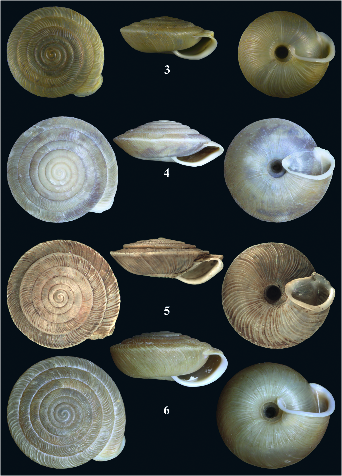


No known copyright restrictions apply. See Agosti, D., Egloff, W., 2009. Taxonomic information exchange and copyright: the Plazi approach. BMC Research Notes 2009, 2:53 for further explanation.
|
Kingdom |
|
|
Phylum |
|
|
Class |
|
|
Order |
|
|
Family |
|
|
Genus |
Lindholmiola lens (A. FéRUSSAC, 1832)
| Subai, Peter & Neubert, Eike 2014 |
Helix lens A. FéRUSSAC
| A. FeRUSSAC 1832 |
Helix lens
| A. FeRUSSAC 1832 |
Helix lens
| A. FeRUSSAC 1832 |
Helix lens
| A. FeRUSSAC 1832 |
Helix lens
| A. FeRUSSAC 1832 |
Helix lens
| A. FeRUSSAC 1832 |
Helix lens
| A. FeRUSSAC 1832 |
Helix lens
| A. FeRUSSAC 1832 |
Helix lens
| A. FeRUSSAC 1832 |
Helix lens
| A. FeRUSSAC 1832 |
Helix lens
| A. FeRUSSAC 1832 |
Helix lens
| A. FeRUSSAC 1832 |
Helix lens
| A. FeRUSSAC 1832 |
Helix lens
| A. FeRUSSAC 1832 |
Helix lens
| A. FeRUSSAC 1832 |
Helix lens
| A. FeRUSSAC 1832 |
Helix (Trigonostoma) lens
| A. FeRUSSAC 1832 |
Helix lens
| A. FeRUSSAC 1832 |
Helix (Anchistoma) lens
| A. FeRUSSAC 1832 |
Helix lens
| A. FeRUSSAC 1832 |
Helix (Caracolina) lens
| A. FeRUSSAC 1832 |
Helix (Caracollina) lens
| A. FeRUSSAC 1832 |
Helix (Caracolina) lens
| A. FeRUSSAC 1832 |
Helix lens
| A. FeRUSSAC 1832 |
Helix (Caracollina) lens
| A. FeRUSSAC 1832 |
Helix (Anchistoma) lens
| A. FeRUSSAC 1832 |
Helix (Gonostoma) lens
| A. FeRUSSAC 1832 |
Helix barbata A. FéRUSSAC
| A. FeRUSSAC, Tableaux 1821 |
Helix barbata
| A. FeRUSSAC, Tableaux 1821 |
barbata FéRUSSAC
| A. FeRUSSAC, Tableaux 1821 |
Helix barbata
| A. FeRUSSAC, Tableaux 1821 |
Helix (Gonostoma) barbata
| A. FeRUSSAC, Tableaux 1821 |
barbata FéRUSSAC
| A. FeRUSSAC, Tableaux 1821 |