
Desplatsia dewevrei (De Wild. & T.Durand) Burret
|
publication ID |
https://doi.org/ 10.5852/ejt.2019.584 |
|
persistent identifier |
https://treatment.plazi.org/id/BF451D61-3047-FF9C-77FA-B4E5920B4560 |
|
treatment provided by |
Felipe |
|
scientific name |
Desplatsia dewevrei (De Wild. & T.Durand) Burret |
| status |
|
Desplatsia dewevrei (De Wild. & T.Durand) Burret View in CoL
Figs 1C View Fig , 2B View Fig , 3C View Fig , 4 View Fig C-D, 6A–B, 7, Table 1
Wissenschaftliche Ergebnisse der Deutschen Zentral-Afrika-Expedition, 1907–1908, unter Führung Adolf Friedrichs, Herzogs zu Mecklenburg. Vol. 2: Botanik: 496 ( Mildbraed 1912). – Grewiopsis dewevrei De Wild. & T.Durand , Bulletin de la Société royale de Botanique de Belgique, Comptes- Rendus des Séances 38 (2): 177 ( De Wildeman & Durand 1899). – Grewiella dewevrei (De Wild. & T.Durand) T. & H.Durand, Sylloge Florae Congolanae: 70 ( Durand & Durand 1909). – Type: DEMOCRATIC REPUBLIC OF CONGO • Bumba; 5 Jun. 1896; A.P. Dewèvre 901; lectotype: BR[BR0000008965905], designated here, isolectotype: BR[BR0000008964618].
Desplatsia dewevrei var. subintegrifolia (De Wild. & T.Durand) Burret, Wissenschaftliche Ergebnisse der Deutschen View in CoL Zentral-Africa-Expedition, 1907–1908, unter Führung Adolf Friedrichs, Herzogs zu Mecklenburg. Vol. 2: Botanik: 496 ( Mildbraed 1912). – Grewiopsis dewevrei var. subintegrifolia De Wild. & T.Durand View in CoL , Bulletin de la Société royale de Botanique de Belgique, Comptes-Rendus des Séances 38 (2): 178 ( De Wildeman & Durand 1899). – Grewiella dewevrei var. subintegrifolia (De Wild. & T.Durand) T.Durand & H.Durand, Sylloge Florae Congolanae : 70 ( Durand & Durand 1909). – Type: DEMOCRATIC REPUBLIC OF CONGO • Bokakata; 1896; A.P. Dewèvre 803; holotype: BR[BR0000008965578].
Grewiopsis trillesiana Pierre ex De Wild., Annales du Musée View in CoL du Congo belge. Série 5 Botanique. Vol. 1: Etudes de systématique et de géographie botanique sur la Flore du Bas- et du Moyen- Congo: 57 ( De Wildeman 1903), syn. nov. – Desplatsia trillesiana (Pierre ex De Wild.) Pierre ex A.Chev., Les View in CoL végétaux utiles de l’Afrique tropicale française. Etudes scientifiques et agronomiques. Vol. 9: 81 ( Chevalier 1917), syn. nov. – Type: GABON • Bota; Sep. 1899; R.P.H. Trilles 189; lectotype: P[MNHN-P-P06610888], designated here, isolectotypes: BR[BR0000020060992], P[MNHN-P-P06610887].
Desplatsia lutea A.Chev. ex Hutch. & Dalziel View in CoL , Flora of West Tropical Africa 1: 240 ( Hutchinson & Dalziel 1927). – Type: IVORY COAST • Pays de Dyolas ; 26 Apr. 1909; A. J. B. Chevalier 21323; lectotype: K [ K000241881 ], designated here, isolectotypes: K [ K000241882 ], P [MNHN-P-P06610828] 2 sheets, WAG [ WAG.1845668]. – NIGERIA • Ibadan Forest Reserve ; 17 Nov. 1900; Punch 50; syntype: K [ K000241880 ] .
Duboscia acuminata A.Chev. , Bulletin de la Société botanique de France 58 (Mémoire 8d): 139 ( Chevalier 1912). – Type: IVORY COAST • Zaranon; A.J.B. Chevalier 16272; lectotype: P[MNHN-P-P00375121], designated here, isolectotype: P[MNHN-P-P00375122].
Other material studied
ANGOLA • Mayumbe ; 1916; J. Gossweiler 6183; BM • Cabinda; 5°33′ S, 12°12′ E; J. Gossweiler 6640; BM, K GoogleMaps .
CAMEROON • Apr. 1895; G. L. Bates 164; K • Bitye , Yaoundé; 3°01′ N, 12° E; G. L. Bates 919; BM GoogleMaps • 1 km above Gr. Batanga ferry; 2°52′ N, 9°54′ E; 24 Jan. 1969; J. J. Bos 3761; P GoogleMaps • Bertoua , 5 km along road to Batouri, before junction of road to Bétaré Oya; 4°35′ N, 13°44′ E; 29 Jul. 1961; F. J. Breteler 1707; WAG [ WAG.1845714] 2 sheets GoogleMaps • Ndanan ; 2 3°37′ N, 11°34′ N; 15 Oct. 2002; M. R. Cheek 11113; BR [ BR0000019964195 ], K, WAG [ WAG.1845732] • Djoum ; 2°35′ N, 12°49′ E; 5 Dec. 2014; M. R. Cheek 17802; K GoogleMaps • Likomba Bush , Tiko; 17 Nov. 1971; S. N. Ekema E41 ; WAG [ WAG.1845740] 2 sheets • 1935; Foury 96; P • Djembe road head; 2°12′ N, 16°05′ E; 17 Oct. 1998; D. J. Harris 5954; E [ E00930969 ] GoogleMaps • Small Bai ; 2°19′ N, 15°46′ E; 31 Oct. 1998; D. J. Harris 6096; E GoogleMaps • Yokadouma ; 3°15′ N, 15°03′ E; 8 Apr. 1927; S. A. Hedin 616; P GoogleMaps • near Sanaga , road from Bafia to Yaoundé; 3°52′ N, 11°31′ E; 1928; S. A. Hedin 1925; P GoogleMaps • Mdiki ; Nov. 1938; H. Jacques-Félix 2509; K, P, WAG [ WAG.1845735] 2 sheets • Yaoundé ; 3°52′ N, 11°31′ E; Aug. 1938; H. Jacques-Félix 4817; P GoogleMaps • ibid.; 1934; R. Juliat 22; P GoogleMaps • 7 km W of Yokadouma ; 3°31′ N, 15°03′ E; 22 Jul. 1965; A. J. M. Leeuwenberg 6232; BR [ BR0000019964157 ], K, WAG [ WAG.1845702] 4 sheets GoogleMaps • Mungo River , near bridge of road Loum-Kumba; 8 Oct. 1965; A. J. M. Leeuwenberg 6844; BR [ BR0000019964218 ], P, WAG [ WAG.1845671] • km 14 Melong- Dschang road; 5°17′ N, 9°59′ E; 19 Jan. 1972; A. J. M. Leeuwenberg 9220; BR [ BR0000019964188 ], WAG [ WAG.1845721] 2 sheets GoogleMaps • near Meuban , 24 km S of Djoum; 2°27′ N, 12°40′ E; 13 Nov. 1966; R. Letouzey 8343; P GoogleMaps • Yaoundé ; 3°52′ N, 11°31′ E; 30 Apr. 1959; B. Mpom 321; P GoogleMaps • Dimako ; 4°22′ N, 13°34′ E; 19 Apr. 1955; P. Nana 24; P GoogleMaps • Deng Deng ; 17 Dec. 1955; P. Nana 384; P • about 7 km NE of Ebom , plot 13; 3°07′ N, 10°45′ E; Aug. 1996; M. P. E. Parren 218; WAG [ WAG.1845713] 2 sheets GoogleMaps • Johann-Albrechtshöhe ; 29 Jan. 1896; A. Staudt 570; BM • Ndahgan 1; 3°37′ N, 11°35′ E; 27 Mar. 2004; F. Tadjouteu 591; K, WAG [ WAG.1845731] GoogleMaps • Southern Bakundu Forest Reserve ; 4°35′ N, 9°23′ E; 10 Feb. 1986; D. W. Thomas 5553; BR [ BR0000019964171 ], K, WAG [ WAG.1845725] GoogleMaps • ca 50 km S of Badjob, SW of Eséka ; 3°41′ N, 10°41′ E; W. J. O. de Wilde 1741 B; BR [ BR0000019964232 ], K, P, WAG [ WAG.1845708] 3 sheets GoogleMaps • ca 40 km S of Badjob, ca 50 km SW of Eséka near the Nyong River; 3°40′ N, 10°40′ E; 18 Dec. 1963; W. J. J. O. de Wilde 1541; P, WAG [ WAG.1845717] GoogleMaps • ca 50 km S of Badjob, SW of Eséka ; 3°41′ N, 10°41′ E; W. J. O. de Wilde 1741 A; BR [ BR0000019964249 ], K, P, WAG [ WAG.1845705] 2 sheets GoogleMaps • Bipinde ; 3°05′ N, 10°25′ E; 1896; G. A. Zenker 924; BM, E [ E00930370 ] 2 sheets, K, M, P GoogleMaps .
CENTRAL AFRICAN REPUBLIC • Dzanga-Sangha Reserve 20 km E of Bayanga; 2°51′ N, 16°28′ E; 17 Nov. 1998; R. W. Carroll 1567; E [ E00930962 ] GoogleMaps • J. M. Fay 8402; MO • J. M. Fay 8414; MO • A. H. Gentry 62581; E • A. H. Gentry 62606; E • 2°21′ N, 16°09′ E; 12 Apr. 1988; D. J. Harris 487; E GoogleMaps • Botembi ; 2 Dec. 1959; M. Guigonis 1871; P • Dzanga-Sangha Reserve, Ndakan ; 2°22′ N, 16°09′ E; 3 Sep. 1988; D. J. Harris 1036; E [ E00930964 ] GoogleMaps • Kongana research camp, 25 km SE of Bayanga; 2°47′ N, 16°16′ E; 31 Jan. 1994; D. J. Harris 4368; E [ E00930965 ] GoogleMaps • ibid.; 1 Feb. 1994; D. J. Harris 4395; E [ E00930967 ] GoogleMaps • Sangha-Mbaere, Kongana camp; 2°47′ N, 16°26′ E; 8 Mar. 1996; D. J. Harris 5496; E [ E00930966 ] GoogleMaps • Kongana camp, 25 km SE of Bayanga; 2°47′ N, 16°26′ E; 4 Nov. 2000; D. J. Harris 7025; E [ E00930951 ] GoogleMaps • ibid.; 5 Nov. 2000; D. J. Harris 7048; E GoogleMaps • ibid.; 9 Nov. 2000; D. J. Harris 7136; E GoogleMaps • ibid.; 9 Nov. 2000; D. J. Harris 7144; E [ E00930961 ] GoogleMaps • Elembe ya Ngombe plot, W of Sangha River; 2°58′ N, 16°11′ E; 1 Dec. 2000; D. J. Harris 7237; E GoogleMaps • Madibwé, close to St. Francois road; ca 12 km NE of Bayanga, 2°58′ N, 16°18′ E; 2 May 2001; D. J. Harris 7502; E GoogleMaps • ibid.; 4 May 2001; D. J. Harris 7550; E [ E00930970 ] GoogleMaps • Boukoko ; 3°54′ N, 17°55′ E; 2 Sep. 1947; C. Tisserant 185; BM, K, P, WAG [ WAG.1845738] GoogleMaps .
CONGO • village of Ouesso-Mbila ; 1°13′ N, 15°47′ E; 17 Jul. 1965; A. Bouquet 1574; P GoogleMaps • Ouesso ; 1°36′ N, 16°03′ E; F. G. Grison 102 RG 907; P GoogleMaps • north side of Sombo stream, 8 km N of Makao; 2°39′ N, 17°10′ E; 1 May 1995; D. J. Harris 5298; E [ E00930968 ] GoogleMaps • Nouabalé-Ndoki National Park , Goualougo study site, 38 km E of Bomassa; 2°10′ N, 16°31′ E; 11 Jun. 2002; D. J. Harris 7975; E GoogleMaps • ca 31 km E of Kabo ; 2°05′ N, 16°21′ E; 19 Feb. 2007; D. J. Harris 8901; E GoogleMaps • ca 41 km NE of Kabo, Nouabalé- Ndoki National Park ; 2°20′ N, 16°19′ E; 7 May 2007; D. J. Harris 9133; E GoogleMaps • ca 39.5 km NE of Kabo, Nouabalé-Ndoki National Park ; 2°15′ N, 16°22′ E; 8 May 2007; D. J. Harris 9149; E GoogleMaps • ca 6.5 km SE of Kabo ; 1°59′ N, 16°05′ E; 17 Jun. 2007; D. J. Harris 9280; E GoogleMaps • ibid.; 17 Jun. 2007; D. J. Harris 9282; E GoogleMaps • ca 18 km ESE of Kabo ; 1°59′ N, 16°14′ E; 19 Jun. 2007; D. J. Harris 9326; E GoogleMaps • ca 10.5 km ESE of Kabo ; 1°59′ N, 16°09′ E; 21 Jun. 2007; D. J. Harris 9368; E GoogleMaps • ca 5 km E of Kabo ; 2°01′ N, 16°07′ E; 22 Jun. 2007; D. J. Harris 9376; E GoogleMaps • ibid.; 22 Jun. 2007; D. J. Harris 9388; E GoogleMaps • ca 2 km S of Kabo ; 2°02′ N, 16°06′ E; 23 Jun. 2007; D. J. Harris 9399; E GoogleMaps • ca 3 km NE of Bomassa , ca 1 km NE of Bon Coin; 2°13′ N, 16°12′ E; 18 Mar. 2010; D. J. Harris 9652; E GoogleMaps • Bomassa , park headquarters; 2°12′ N, 16°11′ E; 21 Mar. 2010; D. J. Harris 9664; E [ E00397442 ] GoogleMaps • Nouabalé-Ndoki National Park , 28 km NE of Bomassa; 2°21′ N, 16°21′ E; 5 May 2018; D. J. Harris 10181; E GoogleMaps • Ouesso ; 1°36′ N, 16°03′ E; 11 Feb. 1970; Inventaire Ouesso 21; P GoogleMaps • ca 12.5 km NE of Kabo ; 2°07′ N, 16°10′ E; 13 Sep. 2006; G. Moukassa 182; E GoogleMaps • ca 16 km NE of Kabo ; 2°07′ N, 16°13′ E; 27 Sep. 2006; G. Moukassa 349; E GoogleMaps • ca 2 km S of Kabo ; 2°02′ N, 16°06′ E; 3 Oct. 2006; G. Moukassa 406; E GoogleMaps • ibid.; 4 Oct. 2006; G. Moukassa 421; E GoogleMaps • ibid.; 4 Oct. 2006; G. Moukassa 422; E GoogleMaps • ibid.; 4 Oct. 2006; G. Moukassa 424; E GoogleMaps • ibid.; 5 Oct. 2006; G. Moukassa 465; E GoogleMaps • ca 6.5 km SE of Kabo ; 1°59′ N, 16°05′ E; 16 Oct. 2006; G. Moukassa 675; E GoogleMaps • ca 27 km E of Kabo ; 2°04′ N; 16°19′ E; 13 Jan. 2007; G. Moukassa 2168; E GoogleMaps • ca 49 km NE of Kabo, Nouabalé-Ndoki National Park ; 2°22′ N, 16°23′ E; 26 Mar. 2007; G. Moukassa 3367; E GoogleMaps • ibid.; 27 Mar. 2007; G. Moukassa 3422; E GoogleMaps • ca 39.5 km NE of Kabo, Nouabalé-Ndoki National Park ; 2°15′ N, 16°22′ E; 14 Apr. 2007; G. Moukassa 3668; E GoogleMaps • ca 24 km ENE of Kabo ; 2°06′ N, 16°17′ E; 24 May 2007; G. Moukassa 4506; E GoogleMaps • village Bomassa ; 2°12′ N, 16°12′ E; 5 Feb. 2013; S. T. Ndolo Ebika 1003; E [ E00757774 ], WAG [ WAG.1576295] GoogleMaps • ca 12.5 km NE of Kabo ; 2°07′ N, 16°10′ E; 8 Sep. 2006; F. O. Nzolani Silaho 166; E GoogleMaps • ca 6.5 km SE of Kabo ; 1°59′ N, 16°05′ E; 10 Oct. 2006; F. O. Nzolani Silaho 510; E GoogleMaps • ca 29 km E of Kabo ; 2°04′ N, 16°20′ E; 8 Jan. 2007; F. O. Nzolani Silaho 1959; E GoogleMaps • ibid.; 8 Jan. 2007; F. O. Nzolani Silaho 1969; E GoogleMaps • ibid.; 9 Jan. 2007; F. O. Nzolani Silaho 2023; E GoogleMaps • ca 5 km E of Kabo ; 2°01′ N, 16°07′ E; 12 Feb. 2007; F. O. Nzolani Silaho 2594; E GoogleMaps • ibid.; 14 Feb. 2007; F. O. Nzolani Silaho 2635; E GoogleMaps • ca 5 km NE of Kabo, Nouabalé-Ndoki National Park ; 2°17′ N, 16°23′ E; 19 Apr. 2007; F. O. Nzolani Silaho 3837; E GoogleMaps • ca 14 km E of Kabo ; 2°00′ N, 16°12′ E; 3 May 2007; F. O. Nzolani Silaho 3862; E GoogleMaps • ibid.; 10 May 2007; F. O. Nzolani Silaho 4115; E GoogleMaps • ca 24 km ENE of Kabo ; 2°06′ N, 16°17′ E; 24 May 2007; F. O. Nzolani Silaho 4358; E GoogleMaps • Placongo ; 2°56′ S, 13°18′ E; 6 Oct. 2009; Placongo Plot Series 102; K GoogleMaps • Mar. 1920; C. H. O. Pobéguin 81; P • Ouesso ; 1°36′ N, 16°03′ E; Jul. 1963; F. Sandberg 58; P GoogleMaps • Apr. 1891; Shelley 4018; P • Modzaka ; 1°42′ N, 18°01′ E; 1889; F.- R. Thollon 24; P GoogleMaps .
DEMOCRATIC REPUBLIC OF CONGO • Yangambi ; 0°46′ N, 24°27′ E; 6 Feb. 1959; P. Bamps 332; BR [ BR0000019964652 ] GoogleMaps • Yailunga ; 2°2′ S, 25°4′ E; 17Apr. 1959; P. Bamps 536; BR [ BR0000019964669 ] GoogleMaps • Yangambi ; 0°46′ N, 24°27′ E; 18 Aug. 1959; P. Bamps 674; BR [ BR0000019964676 ] GoogleMaps • downstream of Barumbu ; 1°14′ N, 23°29′ E; 27 Oct. 1913; J. C. Bequaert 977; BR [ BR0000019964683 ] 3 sheets GoogleMaps • 1918; J. C. Bequaert 1646; BR [ BR0000019964737 ]2sheets • 1919; J. C. Bequaert 3167; BR [ BR0000019964713 ] 2 sheets • Maniema; 1908; A. Berger 1909; BR [ BR0000019964751 ] • Nala ; 2°52′ N, 27°39′ E; 1911; A. Boone 39; BR [ BR0000019964775 ] GoogleMaps • Yaengo, Lobaye River ; 0°28′ N, 24°11′ E; 1 Jun. 2010; Boyekoli Ebale Congo 2010 Expedition 1157; BR [ BR0000005145980 ] GoogleMaps • La Kulu; 3°28′ S, 23°41′ E; 1929; J. F. van den Brande 30; BR [ BR0000020059606 ] GoogleMaps • Plateau of Bateke road Kenge-Kinshasa ; H. Breyne 380; BR [ BR0000019964287 ] • road Maluku-Menkao km 9 Terr. Kin. Maluku ; 4°0′ S, 15°40′ E; H. Breyne 768; BR [ BR0000019964294 ] GoogleMaps • Yangami (plateau Isalowe ); 0°46′ N, 24°27′ E; 12 Feb. 1979; H. Breyne 3621; BR [ BR0000019964782 ] GoogleMaps • Kisantu Lemfu ; 5°7′ S, 15°4′ E; 14 Feb. 1952; H. Callens 2995; BR [ BR0000019964300 ] GoogleMaps • Lukulela, Congo River ; 1°05′ S, 17°20′ E; 5 Jan. 1931; J. P. Chapin 648; BR [ BR0000019964799 ] GoogleMaps • Barumbu ; 1921; J. Claessens 4 (new series); BR [ BR0000019964805 ] • Katembo ; 5°05′ S, 26°22′ E;1921; J. Claessens 68; BR [ BR0000019964645 ] GoogleMaps • Lowani ; 15 Feb. 1910; J. Claessens 483; BR [ BR0000019964829 ] 2 sheets • Buta ; 2°47′ N, 24°43′ E; J. Claessens 677; BR [ BR0000019964843 ] 2 sheets GoogleMaps • Kingana ; 5°40′ N, 15°55′ E; 28 Oct. 1959; P. Compère 686; BR [ BR0000019964317 ] GoogleMaps • Eala ; 0°04′ N, 18°18′ E; 16 Mar. 1932; A. Corbisier-Baland 1236; BR [ BR0000019964867 ] 2 sheets GoogleMaps • Binga ; 2°22′ N, 20°29′ E; 15 Nov. 1946; J. Croegaert 41; BR [ BR0000019964881 ] GoogleMaps • Bas Uele ; 13 Nov. 1934; A. Dewulf 337; BR [ BR0000019964942 ] 2 sheets • Botsima, Parc Salonga , river bank station; 1°09′ N, 21°57′ E; 28 Feb. 1991; M. Dhetchuvi 803; BR [ BR0000019964966 ] GoogleMaps • Yangambi ; 0°46′ N, 24°27′ E; 21 Sep. 1950; C. A. Donis 2776; BR [ BR0000019964973 ], M GoogleMaps • ibid.; 29 Sep. 1950; C. A. Donis 2836; BM, BR [ BR0000019964980 ], P GoogleMaps • ibid.; 29 Sep. 1950; C. A. Donis 2843; BR [ BR0000019964997 ] GoogleMaps • ibid.; 10 May 1951; C. A. Donis 3016; BR [ BR0000019965000 ] GoogleMaps • ibid.; 20 Dec. 1951; C. A. Donis 3222; BR [ BR0000019965017 ] GoogleMaps • ibid.; 20 Dec. 1951; C. A. Donis 3349; BR [ BR0000019965024 ] GoogleMaps • Bambesa ; 3°26′ N, 25°41′ E; 9 May 1944; H. du Bois 915; BR [ BR0000019965048 ] GoogleMaps • ibid.; 25 Jun. 1942; H. du Bois 261; BR [ BR0000019965031 ] GoogleMaps • Kingana ; 5°40′ S, 15°55′ E; 24 Jun. 1958; J. Dubois 317; BR [ BR0000019964324 ], K GoogleMaps • “ Territoire de” [territoryof]EkotaBokutuBoende; 3°26′N, 25°41′E; 15Sep.1934; L. Dubois 610; BR [ BR0000019965055 ] 2 sheets GoogleMaps • Bodangabo ; 3°74′ N, 20°50′ E; 15 Feb. 1955; C. Evrard 217; BR [ BR0000019965079 ] • “Vallée de la Loeka” [ Loeka Valley ]; C. Evrard 3448; BR [ BR0000019965086 ] 2 sheets • Road Bomandja, Ikelambe source; 9 Jun. 1958; C. Evrard 4210; BR [ BR0000019965109 ] • Nioki ; 2°43′ S, 17°41′ E; Jul. 1941; A. Flamigni 6116; BR [ BR0000019964386 ], K GoogleMaps • Buna ; 3°14′ S, 18°59′ E; A. Flamigni 6252; BR [ BR0000019964393 ] GoogleMaps • Kindu-Bangwata ; 2°56′ S, 25°55′ E; 6 Sep. 1957; L. Gaillez 23; BR [ BR0000019965116 ] GoogleMaps • Elundu-Kindu km 37; 2°56′ S, 25°55′ E; 28 Sep. 1957; L. Gaillez 48; BR [ BR0000019965123 ] GoogleMaps • Bambesa ; 3°26′N, 25°41′E; 1Dec.1952; P. Gérard 501; BR [ BR0000019965130 ] GoogleMaps • ibid.; 27 Mar. 1953; P. Gérard 566 A; BR [ BR0000019965147 ] GoogleMaps • ibid.; 3 Oct. 1956; P. Gérard 2489; BR [ BR0000019965154 ] GoogleMaps • Prov. Orientale, Ango, Digba-Ango ; 4°23′ N, 25°48′ E; 5 Nov. 1963; P. Gérard 5592; BR [ BR0000020059422 ], WAG [ WAG.1845719] GoogleMaps • Busiro River , Equateur; Jun. 1936; J. H. P. A. Ghesquière 2689; BR [ BR0000019965178 ] 2 sheets, K • Yasouka ; 15 Nov. 1938; G. Gilbert DIFOR1417 ; BR [ BR0000019965291 ] 2 sheets • G. Gilbert 46; BR [ BR0000019965208 ] • G. Gilbert 706; BR [ BR0000019965222 ] 7 sheets • Route Bengamisa km 34; 0°56′ N, 25°12′ E; 12 May 1936; G. Gilbert 2303; BR [ BR0000019965345 ] 2 sheets, K, P GoogleMaps • Yangambi ; 0°46′ N, 24°27′ E; 1948; G. Gilbert 8614; BR [ BR0000019965369 ] 2 sheets GoogleMaps • ibid.; 1948; G. Gilbert 8627; BR [ BR0000019965383 ] GoogleMaps • ibid.; 1948; G. Gilbert 8651; BR [ BR0000019965390 ] GoogleMaps • ibid.; 1949; G. Gilbert 8692; BR [ BR0000019965406 ] GoogleMaps • ibid.; 1948; G. Gilbert 8708; BR [ BR0000019965413 ] GoogleMaps • ibid.; 1948; G. Gilbert 8843; BR [ BR0000019965420 ] GoogleMaps • ibid.; 1948; G. Gilbert 8920; BR [ BR0000019965437 ] GoogleMaps • ibid.; 1948; G. Gilbert 8991; BR [ BR0000019965444 ] GoogleMaps • ibid.; 1948; G. Gilbert 9098; BR [ BR0000019965451 ] GoogleMaps • ibid.; 1948; G. Gilbert 9758; BR [ BR0000019965468 ] GoogleMaps • ibid.; G. Gilbert 10205; BR [ BR0000006608378 ] GoogleMaps • ibid.; G. Gilbert 10555; BR [ BR0000006860172 ] GoogleMaps • Bankaie ; 2°22′ S, 18°25′ E; 10 Jun. 1953; G. Gilbert 14058; BR [ BR0000019965475 ] GoogleMaps • Bolobo ; 2°9′ S, 16°13′ E; 25 Aug. 1953; G. Gilbert 14715; BR [ BR0000019965482 ] GoogleMaps • Beni ; 0°29′ N, 29°28′ E; 2 Nov. 1931; J. Gillardin 52; BR [ BR0000020059477 ] GoogleMaps • Sangaie-Sankuru ; 4°59′ S, 23°30′ E; 1934; J. Gillardin 134; BR [ BR0000019964409 ] 2 sheets, K, P GoogleMaps • Port Francofin ; 4°19′ S, 20°35′ E; May 1938; J. Gillardin 386; BR [ BR0000019964423 ], K GoogleMaps • Sangaie ; 4°57′ S, 23°33′ E; J. Gillardin 537; BR [ BR0000019964430 ] 2 sheets GoogleMaps • Mukumari “Territoire de Lomela” [Lomela Territory]; May 1939; J. Gillardin 563; BR [ BR0000019965499 ] 2 sheets • Madina Forest ; P. Gille 272; BR [ BR0000006608705 ] 2 sheets • J. Gillet 9; BR [ BR0000019964348 ] • Kinshasa; 4°18′ S, 15°18′ E; 1902; J. Gillet 1625; BR [ BR0000019964362 ] GoogleMaps • between Kisantu and Kwango; 5°7′ S, 15°4′ E; 1904; J. Gillet 3721; BR [ BR0000019964379 ] GoogleMaps • Likimi ; 2°49′ N, 20°44′ E; Jan. 2013; S. de Giorgi 184; BR [ BR0000019964898 ] 2 sheets GoogleMaps • Dundusana ; 2°53′ N, 22°23′ E; 1913; S. de Giorgi 1101; BR [ BR0000019964904 ] 2 sheets GoogleMaps • V. Goosens 2494; BR [ BR0000019965512 ] • S. Gorbatoff 83; BR [ BR0000019965529 ] • Mambasa ; 2°29′S, 26°47′E; 6Apr.1981; T. B. Hart 30; BR [ BR0000019965536 ], K GoogleMaps • Kisantu ; 5°7′ S, 15°4′ E; May 1905; F. van Houtte 2103 (in J. Gillet); BR [ BR0000019964355 ] GoogleMaps • Mbole ; 26 Jun. 1944; R. P. Huelstaert 1311; BR [ BR0000019965550 ] • Ebaa ; 2°47′ S, 18°19′ E; 1 Jun. 1951; E. Jans 933; BR [ BR0000013319090 ] GoogleMaps • “Bassin de l′Epulu” [ Epulu Bassin ]; 1°23′ N, 28°34′ E; 17Jun.1916; M. Lacomblez 7; BR [ BR0000019965567 ] GoogleMaps • 1920; M. Lacomblezs. n.; BR [ BR0000019965574 ] • Botoma Ikelemba ; 0°55′ N, 19°58′ E; 31 Jul. 1905; M. Laurent 1858; BR [ BR0000019965581 ] GoogleMaps • Eala ; 0°3′ N, 18°18′ E; 15 Jun. 1906; M. Laurent 1866; BR [ BR0000019965666 ] GoogleMaps • Kasaï; 11 Nov. 1903; É. Laurent s.n.; BR [ BR0000019964485 ] • 1 Jul. 1903; É. Laurent s.n.; BR [ BR0000019964478 ] • close to Lié ; 6 Jan. 1904; É. Laurent s.n.; BR [ BR0000019964461 ] • Bolombo ; 2 Dec. 1903; É. Laurent s.n.; BR [ BR0000019965628 ] • Lulonga ; 1904; É. Laurent s.n.; BR [ BR0000019965635 ] • river bank below Basako ; 1°14′ N, 23°36′ E; 10 Jan. 1903; É. Laurent s.n.; BR [ BR0000019965604 ] GoogleMaps • Kiri ; 1°26′ N, 19°0′ E; 6 Nov. 1903; É. Laurent s.n.; BR [ BR0000019965611 ] GoogleMaps • Bikoro ; Jul. 1930; J. P. A. Lebrun 1453; BR [ BR0000019965673 ] 2 sheets, U [ U.1380070] • between Libenge and Congo, Ubangi ; 3°39′ N, 18°38′ E; Nov. 1930; J. P. A. Lebrun 1570; BR [ BR0000020059446 ] GoogleMaps • between Businga and Banzyville ; 3°20′ N, 20°53′ E; Jan. 1931; J. P. A. Lebrun 2008; BM, BR [ BR0000019965697 ] GoogleMaps • between Niangara and Wamba ; 3°41′ N, 27°52′ E; Jul. 1931; J. P. A. Lebrun 3262; BR [ BR0000020059460 ] 2 sheets, P GoogleMaps • Eala ; 0°04′ N, 18°18′ E; 1936; J. Leemans 150; BR [ BR0000019965710 ] 2 sheets, K GoogleMaps • Eala ; 0°04′ N, 18°18′ E; J. B. Lejeune s.n.; BR [ BR0000019965734 ] GoogleMaps • Kisangani, Île Kongolo, at junction of Lindi with River Zaïre ; 27 Mar. 1977; J. Lejoly 1180; BR [ BR0000019965741 ] • Likimi ; 2°49′ N, 20°44′ E; 15 Sep. 1913; B. Lemaire 77; BR [ BR0000019965758 ] GoogleMaps • Yangambi ; 0°46′ N, 24°27′ E; 22 Jul. 1958; A. Léonard 975; BR [ BR0000019965765 ] GoogleMaps • Walikale ; 1°25′ S, 28°04′ E; 18 Jun. 1959; A. Léonard 4650; BR [ BR0000019965772 ], K GoogleMaps • Kampene ; 3°35′ S, 26°40′ E; 7 Aug. 1959; A. Léonard 5616; BR [ BR0000019965789 ], K GoogleMaps • Ikelamba ; 1 Sep. 1946; J. Léonard 535; BR [ BR0000019965796 ] • C. L é ontovitch 121; BR [ BR0000019965802 ] 2 sheets • Gemena, Mombolo ; 3°15′ N, 19°46′ E; 16 Oct. 1942; C. L é ontovitch 226; BR [ BR0000019965826 ], K GoogleMaps • Madibi ; 4°17′ N, 18°25′ E; 29 Jun. 1904; E. Lescrauwaet 114; BR [ BR0000019964492 ] GoogleMaps • Tumba ; 28 Feb. 1957; L. Liben 2613; BR [ BR0000019964508 ] • near Mwene-Ditu ; 7°0′ S, 23°26′ E; 4 Nov. 1957; L. Liben 3932; BR [ BR0000019964515 ] GoogleMaps • Budjalibala ; 25 Dec. 1926; D. H. Linder 1793; K, P • Yangambi ; 0°46′ N, 24°27′ E; 1935; J. Louis 320; BM, BR [ BR0000013255787 ] 2 sheets, K GoogleMaps • Yangambi, km 6 road to Ngazi ; 0°46′ N, 24°27′ E; 26 Oct. 1935; J. Louis 434; BR [ BR0000013255770 ] 2 sheets GoogleMaps • Yangambi, km 8 on the road to Ndaze ; 0°46′ N, 24°27′ E; 7 Dec. 1935; J. Louis 778; BR [ BR0000013255763 ] 2 sheets, K, P GoogleMaps • “Plateau de la Lusambila” [ Lusambila Plateau ]; 5°23′ S, 27°18′ E; 24 Mar. 1936; J. Louis 1529; BR [ BR0000013255756 ] 2 sheets, K, P GoogleMaps • Yangambi , 5 km N of river; 0°46′ N, 24°27′ E; 20 May 1937; J. Louis 3922; BR [ BR0000020059002 ] GoogleMaps • Yangambi, at Tofende ; 0°46′ N, 24°27′ E; 25 Aug. 1939; J. Louis 15918; BR [ BR0000020059026 ] 3 sheets GoogleMaps • Sankuru Forest ; 15 Jun. 1903; P. E. Luja 15; BR [ BR0000019964522 ] 2 sheets • Ndumba River ; 1°10′ N, 23°14′ E; 3 Nov. 2004; W. R. Q. Luke 10514z; K GoogleMaps • near Likimi ; 2°49′ N, 20°44′ E; 17 Feb. 1910; L. Malchair 169; BR [ BR0000020059057 ] 2 sheets GoogleMaps • Likimi Forest ; 2°49′ N, 20°44′ E; 1910; L. Malchair 422; BR [ BR0000020059071 ] GoogleMaps • Yangambi ; 0°46′ N, 24°27′ E; 8 Sep. 1952; E. Maudoux 378; BR [ BR0000020059095 ] GoogleMaps • ibid.; 9 Sep. 1952; E. Maudoux 385; BR [ BR0000020059088 ] GoogleMaps • Kikwit ; 5°02′S, 18°48′E; 8Aug.1991; B. Masens 756; BR [ BR0000019964546 ], WAG [ WAG.1845711] GoogleMaps • Dundusana ; 2°53′N, 22°23′E;1913; M. G. Mortehan 71; BR [ BR0000020059125 ] GoogleMaps • near Bolanda Village ; 20 Oct. 1913; A. Nannan 5; BR [ BR0000020059132 ] • Wamba ; 16 Nov. 1988; Nsola 1140; BR [ BR0000020061043 ] • between Mwenda and Kalasabango ; 0°24′ N, 29°46′ E; 8 Sep. 1952; H. A. Osmaston 2490 A; BM, BR [ BR0000020059484 ] GoogleMaps • km 215 road Kavumu-Walikale ; 1°27′ N, 28°50′ E; 19 Aug. 1955; R. Pierlot 937; BR [ BR0000020059163 ] GoogleMaps • near Bambesa Uele ; 3°26′ N, 25°41′ E; 1936; R. Pittery 783; BR [ BR0000020059170 ] GoogleMaps • Eala ; 0°03′ N, 18°18′ E; 11 Nov. 1906; L. Pynaert 643; BR [ BR0000020059194 ] GoogleMaps • ibid.; 15 May 1907; L. Pynaert 1279; BR [ BR0000020059217 ] GoogleMaps • ibid.; 15 Sep. 1907; L. Pynaert 1709; BR [ BR0000020059231 ] GoogleMaps • Mobwasa ; 2°35′ N, 23°08′ E; 15 Oct. 1913; F. Reygaert 1054; BR [ BR0000020059255 ] GoogleMaps • ibid.; 15 Oct. 1913; F. Reygaert 1088; BR [ BR0000020059248 ] GoogleMaps • Liwea ; 4°48′ N, 19°04′ E; 16 Nov. 1925; W. Robyns 994; BR [ BR0000020059262 ] 2 sheets GoogleMaps • River Rubi Station ; 9 Dec. 1929; W. Robyns 1136; BR [ BR0000020059286 ] 3 sheets • Lapku ; 1906; A. Sapin s.n.; BR [ BR0000019964560 ] • Madibi ; 1 Jul. 1906; A. Sapin s.n.; BR [ BR0000019964553 ] • Madilu ; 1907; A. Sapin s.n.; BR [ BR0000019964577 ] • Bwado ; 1912; A. Sapin s.n.; BR [ BR0000020059347 ] • between Lubwe and Bemna-Makina ; 1910; A. Sapin s.n.; BR [ BR0000019964584 ] • Eala ; 0°4′ N, 18°18′ E; 15 Nov. 1930; P. Staner 1497; BR [ BR0000020059354 ] 2 sheets GoogleMaps • Gombe ; 22 Apr. 1959; L. Toka 49; BR [ BR0000020059385 ] • Lukolela / Mompoto ; 1°05′ S, 17°20′ E; 13 Jul. 1959; L. Toka 132; BR [ BR0000020059378 ] GoogleMaps • Kikwit ; 5°02′ S, 18°49′ E; 15 Jan. 1914; H. Vanderyst 2872; BR [ BR0000019964614 ] GoogleMaps • ibid.; 15 Jan. 1914; H. Vanderyst 3121; BR [ BR0000019964621 ] GoogleMaps • Kisantu Wombali ; 15 Nov. 1910; H. Vanderyst s.n.; BR [ BR0000019964607 ] • Ipamu ; 1922; H. Vanderyst s.n.; BR [ BR0000019964638 ] • Mobwasa ; 2°39′ N, 23°03′ E; 10 May 1914; F. M. C. Vermoesen 372; BR [ BR0000020059613 ] 3 sheets, P GoogleMaps • Bambesa Bokamba ; 3°26′ N, 25°41′ E; 16 Apr. 1940; J. M. Vrydagh 337; BR [ BR0000020059637 ] GoogleMaps • Bokondji, Lometa ; 20May1959; P.deWanckel65; BR [ BR0000019964928 ] • Parc National Albert Kigoma, near Balozi ; 6°33′ S, 28°22′ E; 15 Jul. 1954; G. F. de Witte 10796; BR [ BR0000019964935 ] GoogleMaps • Yangambi ; 0°46′ N, 24°27′ E; 9 Dec. 1960; F. Yafunga 23; BR [ BR0000020059408 ], K GoogleMaps .
EQUATORIAL GUINEA • near Bocoricho Balachá ; 3°25′ N, 8°34′ E; 13 Aug. 1986; M. F. de Carvalho 2290; U [ U.1380067], WAG [ WAG.1845829] GoogleMaps .
GABON • “Env. de Libreville” [surroundings of Libreville ]; Jun. 1913; H. Courtet s.n.; L [ L.2349655] • Nyanga; 2°18′ S, 11°39′ E; 1914; G. M. P. C. Le Testu 2133; BM, BR [ BR0000020061005 ], K, P GoogleMaps • Lastoursville ; 0°49′ S, 12°46′ E; 28 May 1929; G. M. P. C. Le Testu 7106; BM, BR [ BR0000020061012 ], P GoogleMaps • 5 Dec. 1929; G. M. P. C. Le Testu 7738; BM, P • 7 May 1930; G. M. P. C. Le Testu 8077; BR [ BR0000019964256 ], P • “Reserve des Monts Doudou, Sud-Ouest de la Brigade de Moukalaba” [ Monts Doudou Reserve , SW of Brigade of Moukalaba], village Mourindi; 2°34′ S, 10°44′ E; 22 Mar. 2000; M. S. M. Sosef 935; WAG [ WAG.1834958] GoogleMaps • Nyanga, Mourindi ; 2°19′ S, 10°26′ E; 18 Apr. 2000; M. S. M. Sosef 1338; P GoogleMaps • F.-. R. Thollon 152; BR [ BR0000020060985 ], K, P .
GHANA • near dam on WACRI station; 6°44′ N, 1°36′ W; 2 Nov. 1953; Brewu WACRI6831 ; K, P GoogleMaps • Akim Swedru , Awisa; 5°53′ N, 1°00′ W; Dec. 1933; F. R. Irvine 2079; E [ E00930369 ] GoogleMaps • BIA National Park and Production Reserve, at Kumkumso Park Guard Camp; 6°37′ N, 3°04′ W; 28 Feb. 1996; H. H. Schmidt 2013; WAG [ WAG.1845666] GoogleMaps .
GUINEA • N′Zérékoré ; 7°45′ N, 8°49′ W; Apr. 1944; J. G. Adam 69; P GoogleMaps • Nimba Mountains , Gba Valley; 7°41′ N, 8°24′ W; 28 Jun. 2007; C. C. H. Jongkind 7876; WAG [ WAG.1845696] GoogleMaps • Bossou ; 7°38′ N, 8°30′ W; Jul. 1942; R. Schnell 1406; P GoogleMaps • Iasso-Offin ; Jan. 1928; C. Vigne 1011; P .
IVORY COAST • Man ; 7°24′ N, 7°33′ W; A. Aubréville 959; BR [ BR0000019964102 ], K, P GoogleMaps • Pinhou ; 6°37′ N, 7°20′ W; Jan. 1969; P. Bamps 1964; BR [ BR0000019964096 ], K GoogleMaps • Bouroukrou ; 7°40′ N, 3°12′ W; 5 Jan. 1907; A. J. B. Chevalier 16844; K, P GoogleMaps • Longan ; 26 Mar. 1907; A. J. B. Chevalier 17685; P • Moyen-Comoé , between Ebrinakoué and Diangobo; 6°34′ N, 3°20′ W; 20 Dec. 1909; A. J. B. Chevalier 22618; P GoogleMaps .
LIBERIA • 13 Dec. 1945; W. J. Harley s.n.; WAG [ WAG.1845669] • Zuole area , near Tapeta; 6°41′ N, 8°47′ W; 28 Jan. 1962; A. G. Voorhoeve 769; WAG [ WAG.1845667] GoogleMaps .
NIGERIA • Hunata Ibene ; 23 Feb. 1966; J. O. Ariwaodo 1123; K • Okumu Forest Reserve ; 6°15′ N, 5°06′ E; 19 Dec. 1947; J. P. M. Brenan 8542; K GoogleMaps • Okomu Forest Reserve ; 6°15′ N, 5°06′ E; 27 Feb. 1948; J. P. M. Brenan 9174; BM, K, P GoogleMaps • Ikom ; 5°57′ N, 8°42′ E; 1935; R. Catterall 71; K GoogleMaps • Moor Plantation-Ibadan ; 4 Apr. 1966; C. L. M. van Eijnatten 1326 ; WAG [ WAG.1845726] 3 sheets • Ibadan N. A. Forest Reserve, Mamu; 28 Apr. 1948; Idahosa FHI 22853; K • Akure Forest Reserve , Aponmu high forest; 7°14′ N, 5°03′ E; 28 Oct. 1949; R. W. J. Keay FHI 25494; K GoogleMaps • Akure Forest Reserve , Aponmu; 1 Nov. 1949; R. W. J. Keay FHI 25532; K • Sapoba ; 6°06′ N, 5°53′ E; J. D. Kennedy 1649; BM, BR [ BR0000019964126 ], K GoogleMaps • J.D. Kennedy 1861; BM, BR [ BR0000019964133 ] 2 sheets • Mamu Forest Reserve ; 7°05′ N, 3°55′ E; 6 Sep. 1944; C. F. A. Onochie FHI7661 View Materials ; K GoogleMaps • Ggoja District ; D. R. Rosevear 58/29; K • Sapoba Reserve ; 6°06′ N, 5°53′ E; 28 Nov. 1934; A. F. Ross 233; K GoogleMaps • Nikrowa , Okomu Reserve; 6°14′ N, 5°21′ E; 28 Jan. 1935; A. F. Ross 249; K GoogleMaps • Sapoba , Benin; 6°06′ N, 5°53′ E; 29 Mar. 1935; R. Ross 173; BM GoogleMaps • H. G. Stubbings 148; K • Degama ; 1914; P. A. Talbot 3637; BM .
TOGO • 7 km N of Badou , on the road to Dayes-Konda; 7°35′ N, 0°36′ E; 29 Apr. 1978; M. Hakki 598; K, P GoogleMaps .
UGANDA • Bundibugyo; 0°44′ N, 30°2′ E; 23 Nov. 1991; R. Dechamps 11635; BR [ BR0000019964270 ] GoogleMaps • Budongo Forest ; 1°38′ N, 31°35′ E; Feb. 1935; W. J. Eggeling 1506; BR [ BR0000019964263 ] GoogleMaps • Bwamba Forest ; 0°50′ N, 30°3′ E; Feb. 1935; W. J. Eggeling 1607; K GoogleMaps • Bwamba Forest ; 0°50′ N, 30°3′ E; 1 Feb. 1945; P. J. Greenway 7063; K GoogleMaps .
Description
HABIT. Tree, to 4–12 m tall, DBH to (5–) 10–40 cm; many-branched, branches and twigs slightly tomentose or glabrous.
LEAVES. With 2–3-fid stipules, divided for part of their length into mostly ovate-lanceolate lobes, 5–12 mm long, 2–3 mm wide at base, sharply pointed, glabrous or slightly tomentose; petiole 0.5–1.8 cm long, almost glabrous with rusty indumentum; leaf blade usually drying greenish-brown, oblong-oblanceolate to oblong-elliptic, 10–35 cm long, 3.5–14 cm wide, sub-leathery, glabrous above, mostly glabrous below apart from some scattered single hairs on midrib or some scattered stellate hairs on blade, apex acute to slightly acuminate, base cuneate to rounded, often asymmetric, joining the petiole at different points on the two sides of the lamina, margin coarsely and irregularly toothed with large (up to 1 cm), jagged teeth, with domatia formed of long simple hairs in nerve axils below (but can be lacking).
INFLORESCENCE. An axillary or terminal cyme of 5–7 flowers, usually rather condensed; peduncle 0.7– 2 cm long, glabrous; involucral bracts 5–6, ovate-lanceolate, 3–5 mm long, greyish tomentose, not enveloping the young buds, usually falling off early.
FLOWERS. Pedicellate; pedicels thick, 2–6 mm long, slightly tomentose; buds subglobose, greyishtomentose; sepals white or cream to slightly pale pink, fleshy, oblong-lanceolate, 1–1.4 cm long, 4–6 mm wide, fringed at apex, tomentose; petals oblong-roundish, 2.4–2.8(–4) mm long, 2–2.4 mm wide; ovary 6–10-locular.
FRUITS. Subglobose to elliptic, 10–25 cm long, 8–20 cm wide, flattened at base and apex, obscurely grooved, glabrous.
SEEDS. Obovoid, 1.8 m long, 8 mm wide.
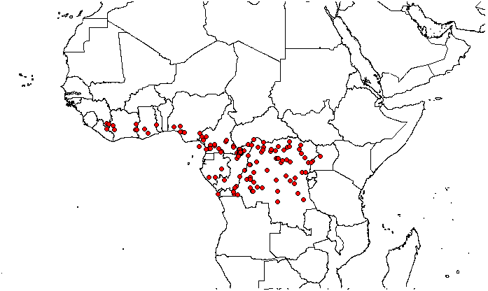
Distribution (see Fig. 7 View Fig )
Angola, Cameroon, Central African Republic, Congo, Democratic Republic of Congo, Equatorial Guinea, Gabon, Ghana, Guinea, Ivory Coast, Liberia, Nigeria, Togo, Uganda.
Habitat
Terra firma forest and occasionally recorded from seasonally flooded forest. At altitudes of 350–1250 m a.s.l.
Phenology
Flower: February–April, September, fruit: February, July, October–November.
Proposed IUCN status
Least Concern (LC). Desplatsia dewevrei has an EOO of 4 271 669 km 2 and an AOO of 572 km 2, with a wide distribution across the forests of West and Central Africa. There are no major threats. Several collections are from protected areas which give this species some level of protection. Our assessment as LC is in agreement with the IUCN Red List assessments of threatened species (BGCI and IUCN SSC Global Tree Specialist Group 2019a).
Notes
Two sheets of Dewèvre 901 collection are available at BR, here we selected the better conserved sheet as lectotype for Grewiopsis dewevrei .
The sheet with fruits and flowers out of the two sheets found in Paris of the Trilles 189 collection cited in the protologue for Grewiopsis trillesiana syn. nov. ( Chevalier 1912) was chosen here as lectotype for that name.
Out of the syntypes available at K, P and WAG, a specimen with flowers we have seen at K was chosen as lectotype for D. lutea .
Out of the two specimens available from the Chevalier 16272 collection for D. acuminata , the fruiting specimen was chosen as lectotype.


| A |
Harvard University - Arnold Arboretum |
| J |
University of the Witwatersrand |
| B |
Botanischer Garten und Botanisches Museum Berlin-Dahlem, Zentraleinrichtung der Freien Universitaet |
| K |
Royal Botanic Gardens |
| P |
Museum National d' Histoire Naturelle, Paris (MNHN) - Vascular Plants |
| WAG |
Wageningen University |
| BM |
Bristol Museum |
| G |
Conservatoire et Jardin botaniques de la Ville de Genève |
| L |
Nationaal Herbarium Nederland, Leiden University branch |
| F |
Field Museum of Natural History, Botany Department |
| M |
Botanische Staatssammlung München |
| R |
Departamento de Geologia, Universidad de Chile |
| BR |
Embrapa Agrobiology Diazothrophic Microbial Culture Collection |
| S |
Department of Botany, Swedish Museum of Natural History |
| N |
Nanjing University |
| E |
Royal Botanic Garden Edinburgh |
| H |
University of Helsinki |
| W |
Naturhistorisches Museum Wien |
| NE |
University of New England |
| O |
Botanical Museum - University of Oslo |
| MO |
Missouri Botanical Garden |
| C |
University of Copenhagen |
| T |
Tavera, Department of Geology and Geophysics |
| V |
Royal British Columbia Museum - Herbarium |
| É |
Royal Botanic Garden Edinburgh |
| U |
Nationaal Herbarium Nederland |
| Q |
Universidad Central |
| BIA |
British Institute of Archaeology |
| FHI |
Forestry Research Institute of Nigeria |
No known copyright restrictions apply. See Agosti, D., Egloff, W., 2009. Taxonomic information exchange and copyright: the Plazi approach. BMC Research Notes 2009, 2:53 for further explanation.
|
Kingdom |
|
|
Phylum |
|
|
Class |
|
|
Order |
|
|
Family |
|
|
Genus |