
Orectoderus montanus Knight, 1968
|
publication ID |
https://doi.org/ 10.1206/3703.2 |
|
DOI |
https://doi.org/10.5281/zenodo.4574303 |
|
persistent identifier |
https://treatment.plazi.org/id/A87EAD38-FF25-EB4B-F0BC-3E8CFCD2FA80 |
|
treatment provided by |
Felipe |
|
scientific name |
Orectoderus montanus Knight |
| status |
|
Orectoderus montanus Knight View in CoL
Figures 3 View FIGURE 3 , 5 View FIGURE 5 , 6 View FIGURE 6 , 11 View FIGURE 11 ; map 2; tables 1, 2
Orectoderus montanus Knight, 1968a: 315 View in CoL (new species, description); Kelton, 1980: 289 (diagnosis, host, distribution, map).
Orectoderus utahensis Knight, 1968a: 315 View in CoL (new species, description); Polhemus, 1994: 131 (distribution, host). NEW SYNONYMY.
Orectoderus salicis Knight, 1968a: 316 View in CoL (new species, description, host); Polhemus, 1994: 131 (distribution, host). NEW SYNONYMY.
Orectoderus cockerelli Knight, 1968a: 317 View in CoL (new species, description); Polhemus, 1994: 130 (distribution, host). NEW SYNONYMY.
TYPE MATERIAL (EXAMINED): Orectoderus montanus : HOLOTYPE: Male: [ USA: Wyoming: Park Co.] Yellowstone National Park [44.76667°N 110.23333°W] 08 Aug 1927, H.H. Knight ( AMNH _ PBI 00068975 View Materials ) ( USNM) GoogleMaps . PARATYPE: [ USA] Wyoming: Park Co.: Yellowstone National Park [44.76667°N 110.23333°W] 20 Jul 1920 – 25 Jul 1920 [1925 in original description], A.A. Nichol, 1♂ (00096918) ( AMNH) GoogleMaps .
Orectoderus utahensis : HOLOTYPE: Male: [ USA: Utah: Wasatch Co.] Heber [40.50689°N 111.41323°W] 1928, C.J.D. Brown ( AMNH _ PBI 00069136 View Materials ) ( USNM) GoogleMaps . PARATYPE: [ USA: Colorado] 4 miles S of Grand Mesa , 09 Jul 1938, R. Bauer, 1♂ (00096193) ( AMNH) .
Orectoderus salicis : HOLOTYPE: Male: [ USA: Colorado: Clear Creek Co.] Berthoud Pass [39.79805°N 105.77777°W] 3452 m, 17 Jul 1964, H.H. Knight ( AMNH _ PBI 00069135 View Materials ) ( USNM) GoogleMaps . PARATYPES: [ USA: Colorado: Clear Creek Co.] Berthoud Pass [39.79805°N 105.77777°W] 3452 m, 17 Jul 1964, H.H. Knight, 1♂ (00096919) ( AMNH) GoogleMaps .
Orectoderus cockerelli : HOLOTYPE: Male: [ USA: Colorado: Teller Co.] Florissant [38.94555°N 105.28916°W], Jul 1916, T.D.A. Cockerell, Potentilla fruticosa (Rosaceae) (AMNH_PBI 00068981) (USNM).
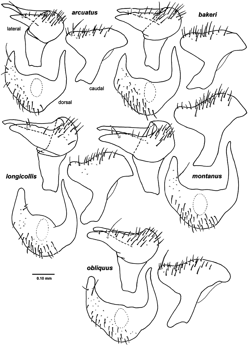
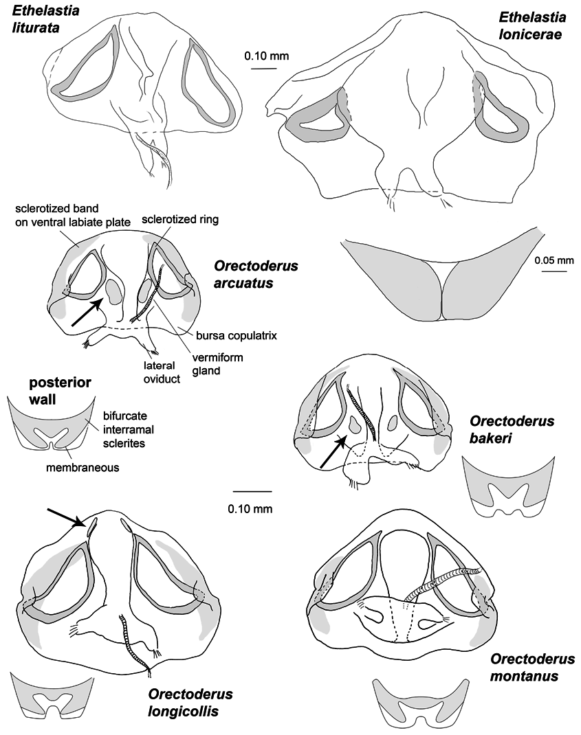
DIAGNOSIS: Recognized by greyish aspect of pronotum (fig. 3), golden, shiny pubescent setae on pronotum and wide and strongly sclerotized vesica (fig. 5); most similar to O. longicollis in vesica and pronotum shape and pronotal vestiture, distinguished by its brown clavus and pale band parallel to claval suture; female with large sclerotized rings, pointed apically (fig. 11). In general aspect, vesica and vestiture similar to montanus , but distinguished by leπ paramere with long seta on inner surface of anterior process (fig. 6), and vesica with denticulate lobe, in lateral view, straight (fig. 5, arrow).
REDESCRIPTION: Male: Total length 5.45–6.71, length apex clypeus-cuneus fracture 3.82– 5.00, width across pronotum1.23–1.48. COLORATION: Clavus brown with narrow pale band parallel to claval suture (fig. 3); corium brown with pale band parallel to claval suture usually ending just right before or slightly reaching apex of clavus. SURFACE AND VESTITURE: General aspect rugose, pubescent and faintly shiny; pronotum and scutellum faintly shiny; dorsal surface and pronotum bearing fine, pale reclining setae shorter than diameter of first antennal segment. STRUCTURE: Labium reaching to mesocoxa. GENITALIA: Secondary gonopore with large denticulate lobe, in lateral view, straight (fig. 5); anterior process of leπ paramere bearing distinct long seta on inner surface (fig. 6).
Female: Total length 4.62–5.63, width across pronotum 0.91–1.09. COLORATION: Head, pronotum, mesoscutum, scutellum and hemelytra greyish brown (fig. 3). SURFACE AND VESTITURE: General aspect dull; head and pronotum dull; pronotum clothed with fine, pale setae. STRUCTURE: Second antennal segment just slightly inflated distally (fig. 3). GENITALIA: Sclerotized rings of dorsal labiate plate large, elongate, and pointed apically; posterior wall with bifurcate interramal sclerites, almost straight medially (fig. 11). HOSTS: Chrysothamnus nauseosus (Asteraceae) , Symphoricarpos sp. ( Caprifoliaceae ), and Potentilla fruticosa (Rosaceae) . DISTRIBUTION: Canada: Alberta, Saskatchewan. United States: Colorado, Idaho, Montana, Nevada, North Dakota, Utah, and Wyoming (map 2). DISCUSSION: The shape of the pronotum among specimens of Orectoderus montanus is slightly variable, but always more or less dis-
MAP 2. Distribution of Orectoderus montanus . tinctly campanulate with the outer distal margin concave. Examination of the holotype and paratype of O. utahensis , holotype and paratype of O. salicis Knight , and the holotype of O. cockerelli (the only known specimen) suggests that these nominal species are the same as montanus . Their general aspect, vestiture, and second antennal segment do not show any differences, and I am therefore treating the first three as junior synonyms of the last, new synonymy. O. montanus , O. cockerelli , O. salicis , and O. utahensis were described in the same publication ( Knight, 1968a). The last three species have not been discussed subsequently, whereas O. montanus was redescribed by Kelton (1980). For this reason, maintaining nomenclatorial stability, O. montanus is chosen here as senior synonym.
SPECIMENS EXAMINED: CANADA: Alberta: Clarinda , 49.09566°N 111.74316°W, 960 m, 15 May 1952, L.A. Konotopetz, 1♀ (00059622) ( AMNH) GoogleMaps . 3♂ (00072872–00072873, 00123239) ( CNC) GoogleMaps . Cowley , 49.56666°N 114.06666°W, 18 Jun 1952, L.A. Konotopetz, 2♂ (00123237, 00123238), 2♀ (00072868, 00072869) ( CNC) GoogleMaps ; 18 Jun 1952, A.R. Brooks, 1♂ (00072870) ( CNC) . Frank , 49.6°N 114.4°W, 18 Jun 1952, L.A. Konotopetz, 1♂ (00072885) ( CNC) GoogleMaps . Irvine , 49.95°N 110.26666°W, 11 Jun 1952, L.A. Konotopetz, 1♂ (00072246) ( CNC) GoogleMaps ; 11 Jun 1952, A.R. Brooks, 1♀ (00059315) ( AMNH) . 3♂ (00072874– 00072875, 00123241) ( CNC) ; 11 Jun 1952, L.A. Konotopetz, 4♂ (00072876–00072879) ( CNC) . Kananaskis Hwy , 50.91555°N 115.14166°W, 25 Jul 1973, L.A. Kelton, 3♂ (00072249, 00072901, 00123235) ( CNC) GoogleMaps . Kananaskis Rd. , 50.91555°N 115.14166°W, 20 Jul 1975, L.A. Kelton, 4♂ (00072897–00072900) ( CNC) GoogleMaps ; 21 Jul 1974, L.A. Kelton, 1♂ (00072896) ( CNC) ; 27 Jul 1974, L.A. Kelton, 1♂ (00123232) ( CNC) . Lethbridge , 49.7°N 112.83333°W, 05 Jun 1930, J.H. Pepper, 1♂ (00072905) ( CNC) GoogleMaps ; 17 Jul 1949, L.K. Peterson, 1♂ ( UASM) . Livingstone Falls, Livingstone River , 50.10138°N 114.44166°W, 17 Jul 1964, H.B. Leech, 1♀ (00077695) ( AMNH) GoogleMaps . Medicine Hat , 50.03333°N 110.68333°W, unknown, 2♂ (00072894, 00072895) ( CNC) GoogleMaps ; 15 Jun 1930, J.H. Pepper, 3♂ (00072890–00072892) ( CNC) ; 14 Jun 1930, J.H. Pepper, 4♂ (00072888–00072889, 00123233–00123234) ( CNC) . Milk River , 49.13333°N 112.08333°W, 16 Jun 1952, A.R. Brooks, 1♂ (00072902) ( CNC) GoogleMaps . Morrin , 51.66666°N 112.76666°W, 27 Jun 1939, P.J.G. Rock, 1♂ (00072871) ( CNC) GoogleMaps . Pincher , 49.48333°N 113.95°W, 09 Jul 1941, R.W. Salt, 1♂ (00072906) ( CNC) GoogleMaps . Spring Point , 59.43333°N 109.73333°W, 18 Jun 1952, L.A. Konotopetz, 2♂ (00072886, 00072887) ( CNC) GoogleMaps . Walsh , 49.95°N 110.03333°W, 28 May 1952, A.R. Brooks, 2♂ (00072880, 00072881) ( CNC) GoogleMaps ; 28 May 1952, L.A. Konotopetz, 2♂ (00072247, 00072248) ( CNC) . Waterton Lakes National Park , 49.05°N 113.9°W, 04 Jul 1923, J. McDunnough, 1♂ (00096202) ( AMNH) GoogleMaps ; 04 Jun 1970 – 06 Jun 1970, L.A. Kelton, 2♂ (00072903, 00072904) ( CNC) . Waterton Park , 49.05°N 113.91666°W, 04 Jul 1970 – 06 Jul 1970, L.A. Kelton, 1♂ (00123236) ( CNC) GoogleMaps . Saskatchewan: Great Sand Hills , 50.5°N 109.08333°W, 04 Jul 1952, A.R. Brooks, 1♂ (00072893) ( CNC) GoogleMaps . USA: Colorado: Clear Creek Co.: Echo L. 10, Mount Evans , 39.65832°N 105.60333°W, 183 m, 13 Jul 1961, J R. Stainer, 5♂ (00072590–00072594), 3♀ (00072595–00072597) ( CNC) GoogleMaps ; 19 Jul 1961, J.R. Stainer, 7♂ (00072598–00072604) ( CNC) ; 26 Jul 1961, J.R. Stainer, 6♂ (00072605–00072610), 4♀ (00072611–00072614) ( CNC) ; 26 Jul 1961, B.H. Poole, 2♂ (00072615, 00072616), 1♀ (00072617) ( CNC) ; 12 Jul 1961, W.R.M. Mason, 1♀ (00072618) ( CNC) ; 20 Jul 1961, B.H. Poole, 2♂ (00072619, 00072620) ( CNC) . Mount Evans , 39.58056°N 105.59167°W, 3658 m, 14 Aug 1982, J.T. Polhemus, 2♂ (00059318, 00096201), 2♀ (00096895, 00096896) ( AMNH) GoogleMaps . 21♂ (00063807– 00063827) ( JTP) GoogleMaps ; 14 Aug 1982, J.T. and D.A. Polhemus, 2♂ (00063796, 00063797) ( JTP) ; 19 Jul 1980, J.T. Polhemus, 1♂ (00096038), 1♀ (00096893) ( AMNH) . 4♂ (00063803–00063806) ( JTP) . Mount Evans , 39.58859°N 105.64333°W, 4267 m, 25 Jul 1961, B.H. Poole, 1♂ (00072621), 2♀ (00072622, 00072623) ( CNC) GoogleMaps ; 04 Jul 1961, C.H. Mann, 1♂ (00072631), 1♀ (00072625) ( CNC) ; 29 Jul 1961, C.H. Mann, 1♀ (00072626) ( CNC) ; 03 Aug 1961, B.H. Poole, 1♂ (00072632) ( CNC) . Mount Goliath Natural Area , 39.63833°N 105.59444°W, 3414 m, 21 Aug 1986, R.T. Schuh and J.T. Polhemus, 1♂ (00096927) Potentilla fruticosa L. ( Rosaceae ), 3♂ (00059320, 00096035–00096036), 21♀ (00058500, 00059317, 00096703– 00096706, 00096897–00096911) ( AMNH) GoogleMaps ; 21 Aug 1982, D.A. and J.T. Polhemus, 2♂ (00096929, 00096930), 1♀ (00096707) ( AMNH) . 1♂ (00063798), 1♀ (00063799) ( JTP) . 1♀ (00092949) ( TAMU) ; 14 Aug 1982, D.A. and J.T. Polhemus, 1♀ (00096894) ( AMNH) . 1♂ (00063802) ( JTP) ; 08 Aug 1983, D.A. and J.T. Polhemus, 1♀ (00092950) ( TAMU) . Timberline, II, Mt. Evans , 39.58859°N 105.64333°W, 183 m, 21 Jul 1961, J.R. Stainer, 1♂ (00072624) ( CNC) GoogleMaps ; 11 Jul 1961, J.R. Stainer, 2♂ (00072627, 00072628), 1♀ (00072629) ( CNC) ; 11 Jul 1961, S.M. Clark, 1♂ (00072630) ( CNC) . below Goliath Peak , 39.73574°N 105.52289°W, 3414 m, 21 Aug 1986, D.A. and J.T. Polhemus, Potentilla fruticosa (Rosaceae) , 1♂ (00063487), 2♀ (00063488, 00063489) ( JTP) GoogleMaps ; 08 Aug 1982, D.A. and J.T. Polhemus, 1♂ (00063800), 1♀ (00063801) ( JTP) ; 08 Aug 1983, D.A. and J.T. Polhemus, 1♀ (00092759) ( TAMU) . Eagle Co.: Vail , 39.64028°N 106.37361°W, 2591 m, 23 Jun 1986, J.T. Polhemus, Symphoricarpos sp. ( Caprifoliaceae ), 4♂ (00063786–00063789), 7♀ (00063492, 00063790–00063795) ( JTP) GoogleMaps . La Plata Co.: Durango, Junction Creek Road, 37.28763°N 107.87562°W, 09 Jul 1968, E.C. Becker, 2♂ (00072560, 00072561) ( CNC) GoogleMaps . La Plata, San Juan National Forest , 37.39722°N 108.0625°W, 2591 m, 19 Jul 1968 – 21 Jul 1968, L.A. Kelton, 1♂ (00072562) ( CNC) GoogleMaps . Larimer Co.: Fall River Pass, 40.44027°N 105.75472°W, 488 m, 12 Aug 1948, H.G. & D. Townes, 1♂ (00069375), 1♀ (00068952) ( USNM) GoogleMaps . Fall River Rd, Rocky Mountains National Park , 40.40445°N 105.62513°W, 2896 m, 16 Aug 1968 – 18 Aug 1968, L.A. Kelton, 2♂ (00072668, 00072669), 2♀ (00072670, 00072671) ( CNC) GoogleMaps . Mesa Co.: 4 miles S of Grand Mesa , 09 Jul 1938, U. Lanham, 2♂ (00068905, 00068906) ( USNM) . Montrose Co.: 2 mi S Columbine Pass , 38.38822°N 108.38056°W, 05 Jul 1980, J.T. and D.A. Polhemus, 5♂ (00063777–00063781), 3♀ (00063782–00063784) ( JTP) GoogleMaps . Sum- mit Co.: Loveland Pass W slope, 39.66361°N 105.87861°W, 3002 m, 08 Aug 1961, B.H. Poole, 4♂ (00072556–00072559) ( CNC) GoogleMaps . Teller Co.: Florissant , 38.94555°N 105.28916°W, 29 Jul 1941, Wm. Buren, 1♂ (00068908) ( USNM) GoogleMaps . Weld Co.: Brainard Lake, Roosevelt National Forest , 40.05111°N 104.9825°W, 3139 m, 02 Aug 1968, L.A. Kelton, Potentilla sp. ( Rosaceae ), 17♂ (00072633–00072649), 18♀ (00072650– 00072667) ( CNC) GoogleMaps . Keenesburg, Sandshill , 40.10833°N 104.51944°W, 11 Jun 1961, B.H. Poole, 2♂ (00072554, 00072555) ( CNC) GoogleMaps . Idaho: Unknown Co.: Henrys , 2134 m, 12 Jul 1936, R.E. Miller, 1♂ (00068907) ( USNM) . Montana: Chouteau Co.: Loma , 47.93666°N 110.50333°W, 785 m, 10 Jun 1959, A.R. Gittins, 1♂ (00086613) ( UID) GoogleMaps . Gallatin Co.: 55 miles S Bozeman , 44.88°N 111.05°W, 11 Jul 1973, Oman and Musgrave, 1♂ (00076084) ( ORSU) GoogleMaps . 63 miles S of Bozeman , 44.81°N 111.09°W, 11 Jul 1973, Oman and Musgrave, 2♂ (00076083, 00076190), 3♀ (00076087, 00076125, 00076185) ( ORSU) GoogleMaps . Gallatin Canyon , 45.43916°N 111.23138°W, 1652 m, 31 Jul 1954, R.C. Froeschner, 1♂ (00096208) ( AMNH) GoogleMaps . West Yellowstone , 44.66215°N 111.1041°W, 2031 m, 03 Aug 1950, R.R. Dreisbach and R.K. Schwab, 1♂ (00127355) ( MSU) GoogleMaps . Madison Co.: 15 mi S of Virginia City, West Fork Camp , 45.07703°N 111.94528°W, 23 Jul 1982, S.E. Cummings, 1♂ (00086842) ( UNHP) GoogleMaps . Park Co.: Colter Campground , 2 mi E Cooke City on Rt 212, 45.01667°N 109.89242°W, 2438 m, 11 Aug 1986, Schuh, Schwartz, and Stonedahl, 1♂ (00096926) ( AMNH) GoogleMaps . Teton Co.: 25 mi N of Choteau , 48.12°N 112.36°W, 30 Jun 1955, R.C. Froeschner, 3♂ (00096203–00096205) ( AMNH) GoogleMaps . 4 mi N of Choteau , 47.85°N 112.23°W, 30 Jun 1955, R.C. Froeschner, 2♂ (00096206, 00096207) ( AMNH) GoogleMaps . Choteau , 47.81333°N 112.18138°W, 1164 m, 28 Jun 1955, R.C. Froeschner, 2♂ (00096209, 00096210) ( AMNH) GoogleMaps . Wheatland Co.: 8 mi N Harlowton , 46.551°N 109.77°W, 01 Jul 1955, R.C. Froeschner, 1♂ (00096211) ( AMNH) GoogleMaps . Nevada: Clark Co.: Top of Las Vegas Range , 36.57139°N 115.03556°W, 28 Jun 1902, N.M., 2♂ (00076934, 00076935) ( CUIC) GoogleMaps . North Dakota: Slope Co.: 4 mi N of Marmath , 46.31666°N 103.83333°E, 26 Jun 2000, T.J. Henry, Chrysothamnus nauseosus (Asteraceae) , 1♂ (00177734), 1♀ (00177735) ( USNM) GoogleMaps . Stark Co.: 127 R Ave. 4 mi N of 48 R St. SW [9 mi S of South Heart], 46.73333°N 103.01666°W, 27 Jun 2000, T.J. Henry, 1♂ (00177736), 2♀ (00177737, 00177738) ( USNM) GoogleMaps . Utah: Utah Co.: American Fork Canyon , 40.37694°N 111.795°W, 25 Jul 1973, G.F. Knowlton, 1♂ (00075469) ( USU) GoogleMaps . North Fork Provo Canyon , 40.36467°N 111.55658°W, Vasco Tanner, 1♂ (00096200) ( AMNH) GoogleMaps . Wyoming: Campbell Co.: Wyodak Plant Station, Gillette , 44.292°N 105.5°W, 24 May 1977, D. Molnar, 1♂ (00096928) ( AMNH) GoogleMaps . Niobrara Co. : Lusk , 42.7625°N 104.45167°W, 21 May 1950, Esselbaugh, 6♂ (00096029–00096033, 00096925) ( AMNH) GoogleMaps . Park Co.: Canyon Village, Yellowstone Natl. Park , 44.76667°N 109.465°W, 21 Jul 1971, G.C. Steyskal, 1♂ (00068983) ( USNM) GoogleMaps ; 12 Aug 1918, A.L. Melander, 1♂ (00068909) ( USNM) . Yellowstone National Park , 44.76667°N 110.23333°W, 20 Jul 1920 – 25 Jul 1920, A.A. Nichol, 1♂ (00069374) ( USNM) GoogleMaps . Teton Co.: Grand Teton National Park , 43.83333°N 110.7°W, 07 Aug 1972, L.A. Kelton, 2♂ (00072907, 00072908) ( CNC) GoogleMaps . Teton Pass , 43.4975°N 110.95444°W, 06 Aug 1972, L.A. Kelton, 1♀ (00072909) ( CNC) GoogleMaps .


| AMNH |
American Museum of Natural History |
| USNM |
Smithsonian Institution, National Museum of Natural History |
| CNC |
Canadian National Collection of Insects, Arachnids, and Nematodes |
| UASM |
University of Alberta, E.H. Strickland Entomological Museum |
| MSU |
Michigan State University Museum |
| CUIC |
Cornell University Insect Collection |
| USU |
Utah State University |
No known copyright restrictions apply. See Agosti, D., Egloff, W., 2009. Taxonomic information exchange and copyright: the Plazi approach. BMC Research Notes 2009, 2:53 for further explanation.
|
Kingdom |
|
|
Phylum |
|
|
Class |
|
|
Order |
|
|
Family |
|
|
Genus |
Orectoderus montanus Knight
| Wyniger, Denise 2010 |
Orectoderus montanus
| Kelton, L. A. 1980: 289 |
| Knight, H. H. 1968: 315 |
Orectoderus utahensis
| Polhemus, D. A. 1994: 131 |
| Knight, H. H. 1968: 315 |
Orectoderus salicis
| Polhemus, D. A. 1994: 131 |
| Knight, H. H. 1968: 316 |
Orectoderus cockerelli
| Polhemus, D. A. 1994: 130 |
| Knight, H. H. 1968: 317 |