
Elacatis umbrosus (LeConte)
|
publication ID |
https://doi.org/ 10.11646/zootaxa.4420.3.1 |
|
publication LSID |
lsid:zoobank.org:pub:6DAD1102-FB24-4933-AA85-6D1879567987 |
|
DOI |
https://doi.org/10.5281/zenodo.5961002 |
|
persistent identifier |
https://treatment.plazi.org/id/03DD87E8-1851-FFA1-FF18-9D38CC5DFB87 |
|
treatment provided by |
Plazi |
|
scientific name |
Elacatis umbrosus (LeConte) |
| status |
|
( Figs 4–6 View FIGURES 1–6 , 20–21 View FIGURES 15–27 , 30 View FIGURES 28–33 , 36 View FIGURE 36 , 40–41 View FIGURES 40–41 )
Othnius umbrosus LeConte 1861: 103 . Type locality: “ Nebraska, near the Rocky Mountains”.— Horn 1868: 132; Packard 1876: 447; Horn 1888: 28; Riley 1893: 242; Cockerell 1898: 169; Borchmann 1910: 1; Fall & Cockerell 1907: 205; Champion 1913: 168; Leng 1920: 152; Borchmann 1921: 210; Chapin 1923: 83; Böving & Craighead 1931: 180, plate 47, figs J–R [larva]; Peterson 1960: 184 –185, fig. C, D [larva]; Young 1991: 547 –548, figs 34.729a-g [larva]; Poole & Gentili 1996: 329.
Othnius lugubris Horn 1868: 132 . Type locality: [southeastern] Oregon.–– Horn 1888: 28, Plate III, fig. 24 a-c; Beutenmüller 1891: 42; Champion 1913: 169; Leng 1920: 152; Borchmann 1921: 211; Hatch 1965: 130, P. XVIII, fig. 9; Campbell 1991: 270; Bousquet et al. 2013: 268. NEW SYNONYM.
Type ( Othnius umbrosus ). According to the original description, LeConte saw only one specimen of his new species. The female HOLOTYPE is labeled: “Neb. // [small square pink label] // [red label] Type 4748 // [handwritten] Othnius umbrosus type. Lec. // Jan.-Jul. 2005 MCZ Image Database // [large red label] HOLOTYPE ♀ Othnius umbrosus LeC. exam. by D.A. Pollock 2017”, in MCZ. The specimen is missing all three left side legs and appears to be teneral.
Type ( Othnius lugubris ). Horn (1868) did not mention the number of specimens he saw, but since there is not a range of measurements, it is likely that there was a single individual, by definition the holotype. Also, there are a number of specimens identified as O. lugubris from both the Horn and LeConte collections ( MCZ) but none are from Oregon (the type locality). The male HOLOTYPE is labeled: “ ♂ // Or. // [red label] TYPE No. 8019 // [handwritten, in Horn’s hand?] O. lugubris Horn // [red label] MCZ Type 34031 // Jan.-Jul 2005 MCZ Image Database // [large red label] HOLOTYPE ♂ Othnius lugubris Horn exam. D.A. Pollock 2017”, in MCZ. The specimen is lacking the left hind leg and abdomen.
Notes on synonymy. Horn (1868: 133) stated that his E. lugubris was distinct from E. umbrosus by “its less elongate form and the uniform color of the elytra. The obtuse teeth of the margin are more distinct and the punctures of the surface of the thorax are less dense and never confluent.” In fact, the holotype of O. umbrosus is very likely teneral, and the holotype of O. lugubris does not have uniformly dark elytra. The same “zig zag” color pattern is visible on both specimens. Also, since both species were founded upon a single specimen, variation was not taken into account by either author. Variation was seen, especially in elytral color, specifically, the degree of light areas. For example, some specimens (including many from British Columbia and Idaho), exhibit distinct light markings, in addition to the light setae ( Fig. 6 View FIGURES 1–6 ). Most examined specimens have dark elytra with the lighter areas reduced and/or marked only by lighter setae ( Figs 4–5 View FIGURES 1–6 ). All specimens associated with dead conifers in North America belong to O. umbrosus .
Diagnosis. Elytra with variously developed lighter colored, “zig-zag” pattern against a darker background ( Figs 4–6 View FIGURES 1–6 ); antennae not obviously sexually dimorphic ( Figs 20–21 View FIGURES 15–27 ); dorsal surface with at least vaguely developed aeneous luster; associated with dead/dying coniferous trees.
Description. TL 3.9–6.0 mm; GEW 1.2–1.9; TL/GEW (n=36) 3.00–3.52.
Color variable; many Canadian (southern British Columbia) and some U.S. specimens with forebody dark redbrown, with at least slight purplish aeneous sheen; elytra with light brown base color, with distinct, lighter, “zigzag” patterning ( Fig. 6 View FIGURES 1–6 ); antennae and mouthparts reddish (antennal club slightly darker); ventral surface and legs reddish brown; other specimens (e.g. Figs 4–5 View FIGURES 1–6 ) with forebody dark brown to near black, with slightly to moderately developed aeneous sheen; elytra with base color similar to forebody, somewhat lighter in some specimens; “zigzag” pattern present, though less extensive than in lighter, northern specimens; mouthparts and antennae dark brown to near black; antennal club darker than antennomeres 1–8 in some specimens; ventral surface and legs as dark as dorsal forebody surface, tarsi somewhat lighter than femora and tibiae.
Head with eyes large, distinctly convex; disc relatively flat, with only indistinct indications of longitudinal furrows and swellings mediad each eye; punctation coarse, moderately deep, punctures separated by much less than single puncture diameter; setae moderately long, of 2 colors: golden and silver/white; white setae mainly along anteromedial eye margins and (in most specimens) forming a small patch between eyes; antennae ( Figs 20– 21 View FIGURES 15–27 ) fairly short, reaching to, or slightly beyond, posterior pronotal margin; antennomeres 4–8 submoniliform to slightly filiform, not distinctly sexually dimorphic; antennomeres 9–10 ( Figs 20–21 View FIGURES 15–27 ) relatively wide, wider than long.
Pronotum. GPW/PL 1.10–1.29; disc moderately convex; punctation deep and dense, similar to head punctation; lateral margins each arcuate to slightly angulate, with sinuations between lateral tubercles; widest point near midlength, marked by anterior-most lateral tubercle; lateral carinae distinct, each with 2 or 3 variously developed tubercles, including hind angle; setae moderately long, more or less apressed, directed anteriorly and medially, in most specimens forming white/silver patches on the dark pronotal background color ( Figs 4–6 View FIGURES 1–6 ).
Elytra. TL/EL 1.61–1.76; EL/GEW 1.71–2.09; elytra relatively elongate; disc of each moderately convex, evenly sloped to lateral margin; punctation relatively coarse and deep, in some specimens forming oblique meshes, especially near humeri; setae relatively short, inconspicuous, color corresponding to light and dark background elytral color.
Male genitalia ( Fig. 30 View FIGURES 28–33 ) with apicale elongate, ca. 1.6 x length of basale; apicale slender, ca. 4.2 x longer than wide; basale subequal in length and width.
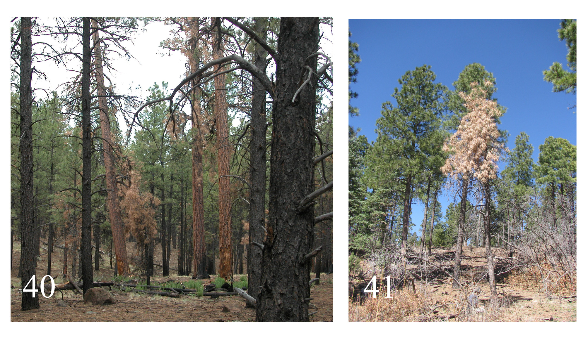
Natural history. Specimens of E. umbrosus have been collected in association with dead conifers, both on/in logs and standing dead trees and snags. Adults have been taken during the day, as they ran along the outer bark of dead, standing conifer trees; individuals have a “halting” or “jerky” movement. Figs 40–41 View FIGURES 40–41 show two examples of typical habitat for adult E. umbrosus in that adults were only collected on the trees with yellow/orange needles, indicating perhaps that the subcortical habitat was suitable for oviposition and subsequent larval development. Larvae are found subcortically, under bark that has been previously loosened by the actions of other woodassociated insects, e.g. scolytine bark beetles (personal observation; Young 1991, Lawrence et al. 2010). I have successfully reared larvae of E. umbrosus to adult in vials containing only the decaying wood collected under the bark of dead coniferous trees, so therefore it appears that larvae are entirely xylophagous (or perhaps partly mycophagous), and not predaceous as assumed in earlier literature. Based on label data of examined specimens, the most common association for adults is with Pinus ponderosa Douglas ex C. Lawson , in its various subspecies, but adults have been collected in association with Pinus contorta Douglas , P. jeffreyi Balf. , P. radiata D. Don , P. edulis Engelm. , Picea engelmannii Parry ex Engelm. , and Pseudotsuga menziesii (Mirb.) Franco. At some localities, many specimens were taken in a relatively short duration using Lindgren funnel traps, especially those baited with various bark beetle (e.g. α-Pinene) or Sirex ( Hymenoptera : Siricidae ) lures (examined specimens; Gaylord et al. 2006, Hofstetter et al. 2008, Steed & Wagner 2008, Hofstetter et al. 2012). In past literature, it was assumed that since the Elacatis adults are attracted in large numbers to these chemical lures that they were preying on the scolytines that were also attracted to these lures. However, I believe that adults of E. umbrosus are attracted to these lures, not because they are predators on scolytines, but because these lures indicate a particular stage of decay, or that a particular tree is currently under assault by bark beetles and therefore the bark will be suitably loose to provide adequate habitat for the Elacatis larvae. The studies listed above have reported relatively large numbers of E. umbrosus being attracted to these baits, e.g. over 5,000 adults of this species collected in two years’ field seasons in northern Arizona ( Gaylord et al. 2006).
An adult E. umbrosus (Torrance Co., NM) was placed in a vial with a piece of bark and four small adult Diptera; though the beetle was not seen to consume any of these potential prey items, after three days there was only one fly left and a careful examination of the contents of the vial revealed no trace of the other three individuals. Gut content analysis of a series of specimens collected in Coconino Co., Arizona revealed definite insect exoskeletal material, indicating predatory habits in the adults of E. umbrosus . Therefore, it is possible that adults may feed on adult scolytines (though specialization on them seems unlikely), but the subcortical larval Elacatis are not predaceous. Months of collection (adults) range from January to December.
Distribution ( Fig. 36 View FIGURE 36 ). This species has a wide distribution in western North America, and is found in southern-central British Columbia and all western states, in areas of coniferous forest. It extends east into western Nebraska and South Dakota. The southern extent of its U.S. distribution is southern Arizona, east to the Davis Mountains, Texas. Given its distribution in the southwestern United States, it seems very likely that E. umbrosus is also associated with conifers in Mexico. Adding evidence to this presumption is a series of recently published papers dealing with beetles arriving at dead pine ( González et al. 2009), and beetles associated with scolytines and attracted by various semiochemicals ( Domínguez-Sánchez et al. 2008, Rodríguez-Ortega et al. 2011, Macías- Sámano et al. 2014). It is possible that one of the Mexican species described by Champion (e.g. E. intricatus ) may eventually be synonymized with E. umbrosus , though this was not investigated in the present paper.
Non-type material examined. CANADA. British Columbia. Aspen Grove [49.930216, -120.629667], 10.v.1934, H. Richmond, (MCZ, 1); same locality, 5-10 1934, (UCRC, 1); same locality, 3.v.1934, H.B. Leech, (AMNH, 2); same locality, 14.v.1934, H.B. Leech, under bark Pinus ponderosa , (AMNH, 1); same locality, 27.v.1933, H. Richmond, Pinus ponderosa , (CNC, 1); same locality, 26.v.1933, H. Richmond, Pinus contorta , (CASC, 1); same locality, 12.v.1933, K. Graham, Pinus ponderosa , (CNC, 1); same locality, 12.v.1933, H. Richmond, Pinus contorta , (CNC, 1); same locality, 11.v.1933, H. Richmond, Pinus contorta , (CNC, 2); same locality, 28.v.1933, K. Graham, Pinus contorta , (CNC, 1); same locality, 12.v.1931, J.R. Howell, (CASC, 1); same locality, 1.vi.1933, K. Graham, Pinus contorta , (CNC, 1); same locality, 11.v.1931, H. Richmond, Pinus ponderosa , (CASC, 1); same locality, 12.v.1931, H.A. Richmond, Pinus ponderosa , (PFC, 1); same locality, 3.iv.1931, H.A. Richmond, Pinus ponderosa , (PFC, 1); same locality, 12.v.1933, H.A. Richmond, Pinus contorta , (PFC, 1); Cawston [49.178966, -119.757845], 11.iii.1917, W.R.S. Metcalfe, (CNC, 1); Copper Mtn. [49.328871, - 120.536152], 21.v.1929, G. Stace Smith, Picea engelmanni, (CNC, 2); Kane Valley [49.960971, -120.711687], W. Richmond, Pinus ponderosa , 19.v.1933, (CNC, 3); 7.v.1933, (CNC, 2); 12.v.1933, (CNC, 1); 13.v.1933, (CNC, 1); 3.vii.1933, (CNC, 1); 12.vi.1933, (CNC, 2); 10.vi.1933, (CNC, 1); 12.v.1933, Pinus contorta , (CNC, 1); Kingsvale [49.910506, -120.906652], 15.iv.1921, G.R. Hopping, (CASC, 1); Midday Val[ley] Merritt [50.059657, - 120.893058], 15.viii.1925, W. Mathers, Pinus ponderosa , ex. Fall Collection, (MCZ, 1); same locality and date, ex. Liebeck Collection, (MCZ, 1); same locality, 26.viii.1924, K.F. Audin, (CASC, 1); same locality, 19.viii.1924, R. Hopping, Pinus ponderosa , (CNC, 1); same locality, 5.ix.1926, W. Mathers, Pinus ponderosa , (CNC, 1); same locality, 5.ix.1925, W.M. Mathers, Pinus ponderosa , (UBC, 1); same locality, 7.viii.1924, R. Hopping, Pinus ponderosa , (AMNH, 1); same locality, 26.viii.1924, R. Hopping, Pinus ponderosa , (AMNH, 1; CASC, 1); same locality, 15.viii.1925, W. Mathers, Pinus ponderosa , (CUIC, 2); same locality, 10.ix.1924, K.F. Auden, Pinus ponderosa , (UAIC, 1); same locality, 16.viii.1924, K.F. Auden, Pinus ponderosa , (CASC, 1; RBCM, 1); same locality, 22.viii.2914, K.F. Auden, ex. Pinus ponderosa , (RCBM, 2); 3.ix.1924, (RCBM, 1); same locality, 31.viii.1925, W. Mathers, Pinus ponderosa , (CUIC, 1); same locality, 22.vii.1924, M.L. Cutler, Pinus ponderosa , (CASC, 1); Midday Valley, 20.iv.1920, (CNC, 1); 13.v.1921, (CNC, 1); 30.v.1921, (CNC, 1); Peachland [49.772048, -119.743262], J.B. Wallis, 24.vii.1919, (CNC, 1); 14.vii.1919, (CNC, 1); 15.vii.1912, pine, (CNC, 1); 2.viii.1912, pine, (CNC, 1); same locality, 28.iv.1918, W.R.S. Metcalfe, (CNC, 2); same locality, 5.v.1918, W.R.S. Metcalfe, (JBWM, 1); Vernon [50.26314, -119.270799], 10.iv.1939, (MCZ, 1); Lytton [50.232628, -121.581438], 19.viii.1931, G.J. Spencer, (UBC, 1); Copper Mountain [49.32943, -120.536207], G. Stace-Smith, Picea engelmannii , 21.v.1929, (UBC, 1); 22.v.1929, (UBC, 1); 23.v.1929, (UBC, 1); Rykerts [49.002132, -116.501594], el. 4000’, 19.vi.1959, J. Grant, ex. Pinus ponderosa , (RBCM, 1); Spius Creek [50.1497, -121.0192], 20.iii.1920, R. Hopping, Pinus ponderosa , (PFC, 1); Oliver [49.182228, -119.550459], 15.v.1929, McN., (PFC, 1); Westbank, Riverside Mill, 2.viii.2001, K. Hein, Lindgren FT, (CMNH, 1).
UNITED STATES OF AMERICA. Arizona. Apache Co. Greer [34.009732, -109.4585], 31.v.1970, K. Stephan, (FSCA, 2); Apache N. For., Luna Lk. campground [33.836210, -109.081317] on Hwy 180, 22.viii.1989, D.A. Pollock, coll. as larva under pine bark, (DAPC, 3). Cochise Co. Chiricahua Mts., Turkey Creek, ~2000M, N31°51.280, W109°19.883’ [31.854667, -109.331383], 21.vii.2002, B. Fitzgibbon, ex SPB baited Lindgren traps, near XPB infested Pinus leiophylla , (DAPC, 1); Chiricahua Mts, Pinery Canyon, 2000M, N31°57.557’, W109°18.782’ [31.95928, -109.313033], 21.viii.2001, B. Fitzgibbon, baited Lindgren trap, near XPB infested Chihuahua pine, (DAPC, 1); 22.ii.2002, (DAPC, 1); 28.i.2002, (DAPC, 1); 19.ii.2002, (DAPC, 1); Rustler Park [31.902965, -109.279768], 19.v.1984, L. Gillogly, (CSCA, 1); same locality, 23.vii.1992, Androw & Brattain, (CMNH, 1); Chiricahua M., D.J. & J.N. Knull, 9.vii.1959, (OSUC, 3); 5.vii.1949, (OSUC, 1); 10.vii.1964, (OSUC, 1). Coconino Co. Flagstaff [35.18947, -111.661359], Hopkins, (USNM, 1); same locality, 8.vi.1904, Webb, (USNM, 1); same locality, 3.v.1904, Webb, (USNM, 1); same locality, 10.viii.1904, Webb, (USNM, 1); same locality, 30.vii.1992, J. & M. Huether, (FSCA, 2); Williams [35.250545, -112.190882], 6.6, Barber & Schwarz, (USNM, 2); same locality, 9.viii.1938, D.J. & J.N. Knull, (OSUC, 1); Saddle Mountain, UTM 0433761; 3920671 [35.427262, -111.7297], 8.xi.2006, coll. at Ips lecontei lure, (DAPC, 16); Coconino National Forest, Ashurst Lake [35.01667, -111.4333], 2164 m, 9.xi.2006, [ Ips ] lecontei lure, (DAPC, 32); Coconino National Forest, Cinder Hills [35.3333, -111.5333], 2146 m, 6-13.xi.2006, lecontei lure, (DAPC, 120); Coconino National Forest, Orion Springs [35.28333, -111.65], 2628 m, 8.xi.2006, lecontei lure, (DAPC, 40); Coconino National Forest, Schultz Pass [35.2333, -111.65], 2194 m, 6.xi.2006, lecontei lure, (DAPC, 50); Coconino National Forest, Waterline [35.28333, -111.617], 2505 m, 13.xi.2006, lecontei lure, (DAPC, 30); US 89 & Loop Rd, 35°22’15”N / 111°34’34” [35.370833, -111.576111], 21.iv.2012, J.P. Gruber, crawling on bark of standing dead Pinus ponderosae tree, Pinus ponderosae forest (approx. 7200 ft.), (WIRC, 1); NW of Flagstaff on SR 180, 35.335, -111.782 [35.335, -111.782], 8000’, 23.vi-7.vii.2012, MJ Paulsen, M. Herrmann, lindgrens, (MJPC, 11). Gila Co. March Crk., UTM 0 502515, 3779481 [34.156247, -110.972716], 5372 ft., 14.xi.2006, Lindgren funnel with Ips lecontei lure, (DAPC, 18); 3 mi. N. Sierra Ancha [34.000416, -111.187988], 28.vii.1967, W.F. Barr, (AAAC, 1; WBEM, 1); Tonto National Forest, Moore Creek 34.350, -111.21667], 1,736 m, 14.xi.2006, pini lure, (DAPC, 75). Greenlee Co. Strayhorse Heliport, Hwy. 191, 33.53816°N, 109.31144°W [33.53816, -109.31144], 7600 ft., 17.vii.2012, E.G. & M.L. Riley, (TAMU, 1). Navajo Co. 3 mi. S. ShowLow [34.20839, -110.02935], 7000’, 10.ix.1964, C.W. O’Brien, ex Pinus ponderosa , (FSCA, 1). Pima Co. Catalina Mts., Catalina Hwy. Mt. Lemmon Pinery 30.v.1980, J. Cicero, (FSCA, 1). Yavapai Co. Prescott [34.53923, -112.468176], 24.vi.1959, A. Raske, Pinus ponderosa , (MCZ, 1; CNC, 1); same locality, 10.vi.1959, A. Raske, pond pine, (CNC, 1); Indian Creek Camp [34.482525, -112.501281], Prescott Nat’l Forest, 16.viii.1954, G.H. Nelson, beating black locust, (MCZ, 1); 8 mi. S., 4 mi. E. Prescott [34.403918, -112.39695], 6.vi.1969, W. Harwood, (BYUC, 1); Prescott Nat. For, 2 mi S. Mingus Mtn. [34.663751, -112.12739], 6.iii.1988, S. Seybold, Ips lecontei associate, host Pinus ponderosa , (EMEC, 2); Prescott N.F., 8.5.30, M.W. Blackman, Pinus ponderosa , (USNM, 1). State record only, ex. Horn Collection, (MCZ, 1). County unknown. St. Catalina Mts. , elev. 9000 ft., 25.iv.1970, under bark P. pine, K. Stephan, (FSCA, 3); same locality, 8500 ft., 17.v.1975, K. Stephan, (FSCA, 2); Prescott N.F., 18.vi.1959, (USNM, 1); Grand Canyon, 13.vi.1953, A. & H. Dietrich, (CUIC, 1); same locality, 12.vi.1953, A. & H. Dietrich, (CUIC, 1); Kaibab N.F., 12.viii.1965, R.A. Furniss, Pinon pine, (USNM, 2).
California. Alpine Co. County record only, vii.1934, J.E. Blum, (CASC, 2); Grover Hot Springs St. Pk., 38°41.997’N, 119°50.805’W [38.69995, -119.84675], 1796 m, site #6, 11-25.v.2006, A.R. Cline & P. Kerr, ex: malaise trap near creek. Amador Co. 1 mi. W. Silver Lake [= Plasse] [38.637592, -120.145226], 29.viii.2003, R.L. Penrose, ex. ETOH + pinene, (CSCA, 1). El Dorado Co. U.C. Blodgett Forest, 8 mi. E. Georgetown [38.886238, - 120.647609], 15.ix.1966, C.O. Dudley, (EMEC, 1); same locality, viii.1968, F.M. Stephen, (USNM, 1); same locality, 4.x.1966, C.O. Dudley, (EMEC, 1); Blodgett For., 13 mi. E. Georgetown [38.893014, -120.585938], 26.vi.1973, H.A. Moeck, sticky trap on Pinus ponderosa , (CNC, 2; PFC, 1); same locality, H.A. Moeck, sticky trap on P. ponderosa , 11.vi.1973, (PFC, 1); 19.vi.1973, (PFC, 4); 25.vi.1973, (PFC, 1); Blodgett Forest, 30.v.1986, K. Hobson, (EMEC, 3); same locality, K. Hobson, Lindgren trap, 24-27.v.1986, (EMEC, 1), 21-24.vi.1986, (EMEC, 3), 28-30.vi.1986, 9-16.vii.1986, (EMEC, 1); 1-2.vi.1986, (EMEC, 1); (EMEC, 1), 25-27.vi.1986, (EMEC, 1); 21.vii.1986, (EMEC, 1); same locality, 2.vii.2003, K. Apigian, (EMEC, 1); same locality, 20.v.1973, Wharton, (TAMU, 1); 1 mi. E. Pacific House [38.765832, -120.490421], 25.iv.1991, W.D. Shepard, seining flume, (CASC, 1); Meyers [38.855859, -120.013133], 20.vii.1916, F.B. Herbert, Pinus jeffreyi , (USNM, 1); Fallen Leaf Lk. [38.900542, -120.048966], Eldorado NF, 9.vi.1961, S.L. Wood, J.B. Karren & D.E. Bright, (BYUC, 1). Fresno Co. Oak Flat Camp [NOT FOUND], 3.vii.1933, (CASC, 1); Camp 6 Millwood [NOT FOUND], May 13, (CASC, 1); Stevenson Ck [37.169838, -119.360375], 6500’, K.A. Stone, (CSCA, 1). Glenn Co. Cedar Ridge [39.599601, - 122.744996], 4-10 1913, Pinus ponderosa , (CASC, 1). Kern Co. Cannel Meadow [35.775286, -118.431078], 6-11- 13, Pinus jeffreyi , (CASC, 1); 34.8256°N, 119.0868°W [34.8256, -119.0868], Los Padres NF, Mt. Pinos, 7.vi- 1.vii.2008, M.S. Caterino, cantharidin pitfall, (SBMNH, 1); Mt. Pinos [34.812573, -119.145430], 8.vii.1979, R.W. Surdick, (CMNH, 1). Lassen Co. Facht [not found/mapped], J.O. Martin, 15.v.1922, (CASC, 1), 24.v.1922, (CASC, 1), 25.v.1922, (CASC, 1), 30.v.1922, (CASC, 2); Goumaz [campground] [40.413739, -120.862476], 10.iv.1916, Pinus ponderosa , (CNC, 2); same locality, 15.iv.1916, R. Hopping, (CASC, 2); same locality, 28.iv.1915, R. Hopping, Pinus jeffreyi , (CASC, 2); Norval Flats [NOT FOUND], 5500 ft., 15.v.1920, (CASC, 1); county record only, iv.28, (OSUC, 1). Los Angeles Co. Big Pines [34.377312, -117.689181], 21.viii.1967, L.A. Kelton, under bark, (CNC, 4); Charleton Flats [34.29434, -118.013433], 10.vii.1950, E.R. Estes, (FSCA, 1); Sulfur Springs [34.427094, -119.095217], 5.v.1974, M. Hetz, (UAIC, 1); 6 mi. W. Wrightwood [34.359192, -117.738564] [label reads San Bernardino Co.], 14.iv.1986, F. Andrews, T.D. Eichlin, A. Hardy, under bark conifer, (CSCA, 2). Madera Co. Chiquito Basin, 1.v.1914, on Pinus ponderosa , (MCZ, 1); North Fork [37.228998, -119.509599], 13.iii.1920, H. Dietrich, (CUIC, 18); same locality, 13.v.1933, R.P. Allen, (CASC, 1); Bass Lake [37.323485, - 119.562818], 12.vi.1934, R.P. Allen, (CASC, 2). Mariposa Co. Yosemite Valley [37.745838, -119.594564], 22.vi.1953, D. Giuliani, (CASC, 2); same locality, 14.vi.1969, R.P. Allen, (CSCA, 1); Anderson Valley [NOT FOUND], 6.iii.1914, Pinus ponderosa , (CASC, 1); Miami Ranger Sta. [37.41943, -119.74526], 15.v.1942, A.J. Walz, Pinus ponderosa , (WBEM, 1); same locality, 16.v.1942, Abies concolor, (WBEM, 1). Modoc Co. Hackamore [41.548283, -121.121922], G.L. Smith, yellow pine, 15.vi.1934, (CASC, 1; EMEC, 1), 22.vi.1935, (CASC, 4); same locality, 7-6-30, R.L. Furniss, Pinus ponderosa , (USNM, 1). Mono Co. Bald Mountain [37.769011, -118.898004], Bridgeport, 15.v.1965, M.D. Mcgregor & F.W. Honing, pinyon pine, (USNM, 1). Monterey Co. Jack’s Peak Park [36.563367, -121.869033], 4.x.1979, C.P. Ohmart, Pinus radiata , (ANIC, 1). Napa Co. Pope Valley [38.614747, -122.427708], 4.iv.1961, D.R. Hunter, (CASC, 1). Nevada Co. nr. Hobart Mills [39.99959, -120.183705], 20.vi.1964, M. Irwin, (UCRC, 1); Sagehen Creek [39.430372, -120.241016], 21- 25.vi.1982, J.A. Rosenheim, (BPBM, 1); Truckee [39.329554, -120.184101], 6.vii.1927, E.P. Van Duzee, (CASC, 1); 19.vi.1927, (CASC, 1); B.T.I. [Boyce Thompson Institute] Exp. For., Grass Valley [39.206074, -121.057579], 20.ii.1963, (CSCA, 1); same locality, 23.ii.1963, reared, (CSCA, 1). Placer Co. Carnelian Bay [39.22698, - 120.081704], L. Tahoe, 8.vii.1964, A. Gillogly, (TAMU, 1); Bear Cr blw Alpine Mdws ski area [39.177438, - 120.22819], 21.iv.1987, Baumann & Nelson-Wells, (BYUC, 1); county record only, (CASC, 2). Plumas Co. Mohawk [39.777119, -120.633951], 5.vi.1921, (CASC, 1). Riverside Co. Hurkey Creek Camp [33.675837, - 116.681214], 15.vi.1954, G.H. Nelson, P. ponderosa logs, (MCZ, 1); 33.8071°N, 116.7780°W [33.8071, - 116.7780], SBNF, UC James Reserve, 5-6.iv.2005, M. Caterino, on cut pine logs, (SBMNH, 7); 33.8081°N, 116.7784°W [33.8081, -116.7784], SBNF, UC James Reserve, 3-7.iv.2005, M. Caterino, Lindgren trap, (SBMNH, 5); 33.8105°N, 116.7754°W [33.8105, -116.7754], SBNF, UC James Reserve, 3-7.iv.2005, M. Caterino, Lindgren trap, (SBMNH, 2); 8 mi SE Lk. Hemet [33.581787, -116.588506], 18.ii.1968, S. McCleve, on pine log, (DKYC, 1). San Bernardino Co. 34.1744°N, 116.8971°W [34.1744, -116.8971], SBNF: Glass Rd., 13-20.v.2006, Caterino & Chatzimanolis, Lindgren, (SBMNH, 2); 34.1819°N, 116.8884°W [34.1819, -116.8884], SBNF: Santa Ana River, 13-20.v.2006, Caterino & Chatzimanolis, Lindgren, (SBMNH, 1); 34.3030°N, 116.8996°W [34.3030, -116.8996], SBNF: Holcomb Valley, 17.v.2006, Caterino & Chatzimanolis, (SBMNH, 1); Barton Flats [34.170838, - 116.862894], 25.vi.1966, G.L. Peters, (CSCA, 1; TAMU, 1); S. of Barton Flats, 2071m, 34°10’0”N, 116°52’23”W [34.16667, -116.87306], F.R. Reuter, 1.vi.2006, (UCRC, 2); 30.iv.2006, (UCRC, 15); 5.v.2006, (UCRC, 1); 15.v.2006, (UCRC, 1); 8.vi.2006, (UCRC, 1); Baldwin Lake [34.283455, -116.802845], 7.viii.1921, 8,600 ft., Knaus, Nininger & Hoover, (CNC, 2; CUIC, 1); Big Bear Lake [34.263363, -116.918264], elev. 7000 ft., 24.vii.1938, R. Scott, Ponderosa pine, (AMNH, 1). Santa Barbara Co. 34.7235°N, 120.0462°W [34.7235, - 120.0462], UC Sedgwick Reserve, 22.iv-2.v.2005, M. Caterino, Lindgren trap, (SBMNH, 1). Santa Cruz Co. Santa Cruz [37.003887, -122.009377], 23.ii.1929, E.P. van Duzee, (CASC, 2). Shasta Co. Burney [40.878035, - 121.660096], 2.vi.1966, W.H. Tyson, (TAMU, 1); Hat Creek Work Cntr. [40.830617, -121.513499], v-vi.1990, S. Seybold, (EMEC, 17); Old Station [40.658027, -121.469425], 1 mi SSE Logan Lake, T32N R4E S1&12, M.A. Valenti, ex. Lindgren funnel trap with 2% alpha-pinene bait, 31.v.1993 (CUIC, 2; TAMU, 1), 14.vi.1993, (CSCA, 1); 28.vi.1993, (TAMU, 3), 19.vii.1993, (CUIC, 1); 21.vi.1993, (CUIC, 1); 8 mi SW Old Station [40.592161, - 121.54117], 8.viii.1970, D.S. Chandler, (OSUC, 1); 1.5 mi. E. Baker Lake, T32N, R6E, S7, 30.vi.1990, S. Seybold, caught in flight trap, (EMEC, 1); 0.5 mi. E. Baker Lake, T32N, R5E, S12, 6.vii.1990, S. Seybold, caught in flight trap, (EMEC, 1); Lassen Park [not specific enough to map], 16.vi.1987, K. Allen, (AAAC, 3); 4 mi. NW Viola [40.555002, -121.730291], J.A. Litsinger, 18.viii.1964, (WIRC, 4; MTEC, 1); 31.vii.1964, (WIRC, 1); Manzanita Lake [40.529705, -121.567307], 24.v.1941, (WBEM, 1). Siskiyou Co. Barkhouse [NOT FOUND], 15-16.iii, (CASC, 1); McCloud [41.255826, -122.138873], 21.iv.1899, yellow pine, (USNM, 1). Tehama Co. 35 mi W. Orland Mud Flat Camp [NOT FOUND], 13.v.1961, D.R. Miller, (UCRC, 1). Trinity Co. Big Flat [campground] [40.73932, -123.205882], 20.viii.1947, W. Russell & R. Harlick, (CASC, 1); Carrville [41.064868, -122.70419], 23.v.1913, (CASC, 1), 25.v.1913, (CASC, 2), 3.vi.1913, (CASC, 2), 6.vi.1913, (CASC, 7), 7.vi.1913, (CASC, 1), 11.vi.1913, (CASC, 13), 16.vi.1913, (CASC, 3), 17.vi.1913, (CASC, 1), 20.vi.1913, (CASC, 12), 24.vi.1913, (CASC, 4), 25.vi.1913, (CASC, 4), 26.vi.1913, (CASC, 2), 28.vi.1913, (CASC, 1), 3.vii.1913, (CASC, 1), 5.vii.1913, (CASC, 1); Hayfork [40.55707, -123.184295], 1.x.1912, Pinus ponderosa , (CASC, 1); same locality, 30.iv.1913, Pinus ponderosa , (CASC, 1); same locality, 2.v.1913, Pinus ponderosa , (CASC, 1); Plummer Spring [40.440145, -123.244749], Trinity N.F., 19.ix.1916, Pinus jeffreyi , (CASC, 1); Trinity L.C., Weaverville [40.730446, -122.941366], 28.v.2003, M. Lackhart, ethanol, (CSCA, 2). Tulare Co. 36.6783°N, 118.9661°W [36.6783, -118.9661], Sequoia NF, Whitaker Forest Rd., 5-12.vi.2006, Caterino & Chatzimanolis, Lindgren, (SBMNH, 1); Kaweah R. [36.435289, -118.908122], 20.iv.1918, Hopping, Pinus ponderosa , (CASC, 2; CNC, 4); Middle Fork Kaweah R. [36.428005, -118.909694], 20.iv.1918, Hopping, Pinus ponderosa , (CASC, 3); Wishon CG [36.189663, -118.664115] 12 mi NE Springville, 19.vi.1993, B.F. & J.L. Carr, (CNC, 1). Ventura Co. County record only, Hopkins collector, (USNM, 1). County unknown. Yosemite Nat. Pk., (USNM, 1); S.G. River, xii.33, (EMEC, 3; WBEM, 1); S[an] B[ernar]d[in]o. Mts., 7500 ft., 7-2-17, J.O. Martin, (CASC, 1).
Colorado. Arapahoe Co. Aurora [39.728089, -104.827143], 73 Rd/51 Rd, 13.v.2005, D. Leatherman, ex. ponderosa pine, (CSU, 1). Archuleta Co. CR 631 nr. Sullenburger Res[ervoir] [37.283943, -107.078366], 9.vi.1998, D. Leatherman, ex. ponderosa pine, (CSU, 6). Boulder Co. Boulder [40.012481, -105.270667], iii.1907, ex. Fall Collection, (MCZ, 2); same locality, 8.vi.1961, 5300’, C.H. Mann, (CNC, 1); Allen’s Park [= Allenspark] [40.194568, -105.525578], ex. Fall Collection, (MCZ, 1); state record only, ex. Horn Collection, (MCZ, 5); Sugarloaf [40.01895, -105.407364] area, Black Tiger Fire, 7.viii.1995, D. Leatherman, ex. ponderosa pine, (CSU, 1). Broomfield Co. Broomfield, consolidated hardwood [39.913164, -105.080361], 24.ix.2012, Lindgren funnel, APEtOH lure, (CSU, 1). Costilla Co. Fort Garland [37.428951, -105.433907], 27.iii.1905, McCormick, Pinus and Picea , (USNM, 1). Delta Co. Hotchkiss, Todd Enterprises [38.796432, -107.703039], 23.viii.2012, Lindgren funnel, Ips lure, (CSU, 2). Denver Co. Heron Pond, 39.80238, -104.95918 [39.80238, -104.95918], 15.x.2015, Lindgren funnel, Pityogenes lure, (CSU, 2). Douglas Co. Franktown [39.391086, -104.753132] firewood, 3.x.2006, Lindgren funnel 3 pts. Ips lure, (CSU, 1). El Paso Co. Colorado Springs [38.831807, -104.821605], 7.x.2004, Tomicus lure, (CSU, 3); Colorado Springs, Evergreen Cemetery [38.816589, -104.798062], 25.vii.1999, D. Leatherman, ex. ponderosa pine, (CSU, 2); Black Forest [39.012013, -104.700929], 26.v.2005, D. Leatherman, ex. ponderosa pine, (CSU, 1); Colorado Springs, Rocky Mtn State Park [supposed to be Cheyenne Mountain Park [38.765799, -104.863402], pers. comm. B. Kondratieff], 30.ix.2008, Lindgren funnel, Ips lure, (CSU, 2); county record only, 14.iii.1914, flying, (USNM, 1); 8.iii.1914, (USNM, 3). Fremont Co. Fort Gorge, Canon City [38.448125, -105.223574], 8.x.2007, Lindgren funnel, (CSU, 1). Gilpin Co. Golden Gate [Canyon] State Park, 39.87145, -105.39740 [39.87145, -105.39740], Lindgren funnel, Sirex lure, 25.vi.2015, (CSU, 4); 8.vii.2015, (CSU, 3); 9.vi.2015, (CSU, 3); Golden Gate [Canyon] State Park, 39.858, 105.448 [39.858, -105.448], Lindgren funnel, Sirex lure, 7.vi.2013, (CSU, 6); 21.vi.2013, (CSU, 1); 15.viii.2013, (CSU, 1); Golden Gate [Canyon] State Park, 39.84608, -105.37637 [39.84608, -105.37637], Lindren funnel, UHR EtOH & omega-pinene, 20.x.2015, (UCR, 2). Graham Co. Larkspur [39.227471, -104.884119], Pikes Peak Nat. For., 6.vi.1908, yellow pine, (USNM, 1); Larkspur, 16.v.1914, (USNM, 1). Grand Co. Fraser [39.94436, -105.81708], 4.vii.1911, C.A. Frost, el. 8000’, (MCZ, 1). Jefferson Co. Evergreen [39.633855, -105.317706], 20.viii.1937, Pinus ponderosa , (USNM, 1); Evergreen, Lindgren funnel, UHR EtOH & omega-pinene, 13.x.2011, (CSU, 5), 1-14.vi.2010, (CSU, 1); 30.viii.2012, (CSU, 1); 7-21.x.2010, (CSU, 1); same locality, Lindgren funnel, Sirex lure, 13.x.2011, (CSU, 1); 30.vi-12.vii.2010, (CSU, 3); Evergreen Safeway, 39.6352, 105.3319 [39.6352, -105.3319], 15.ix.2014, Lindgren funnel, Pityogenes lure, (CSU, 1); same locality, 1.x.2014, Lindgren funnel, UHR EtOH & omega-pinene, (CSU, 1); Evergreen, 39.64539, -105.34064 [39.64539, -105.34064], 28.vii.2015, Lindgren funnel, UHR EtOH & omegapinene, (CSU, 1); Conifer [39.519721, -105.30522], Lindgren funnel, Sirex lure, 28.ix.2011, (CSU, 11); 2.viii.2011, (CSU, 1); 14.vi-1.vii.2010, (CSU, 1); 25.v-14.vi.2010, (CSU, 1); nr. Conifer, 39.54046, 105.28765 [39.54046, -105.28765], Lindgren funnel, UHR EtOH & omega-pinene, 1.x.2014, (CSU, 5); 1.viii.2011, (CSU, 4); 20.viii-2.ix.2010, (CSU, 1); 4.x.2011, (CSU, 1); nr. Conifer, 39.54562, 105.32184 [39.54562, -105.32184], 10.vi.2015, Lindgren funnel, Sirex lure, (CSU, 2). La Plata Co. Pine River [NOT FOUND], 23.iv.1919, R. Hopping, Pinus ponderosa , (UAIC, 1; BYUC, 2; CASC, 6); FR 576, 2 mi NW Hermosa [37.438028, -107.849660], 17.iii.2004, D. Leatherman, ex. ponderosa pine, (CSU, 4); Mt. Trailhead, Big Thompson Cyn [40.421082, - 105.226033], 22.iii.1999, D. Leatherman, ex ponderosa pine, (CSU, 2). Larimer Co. 22 km NW Ft. Collins [40.727009, -105.262511], 12.vi.1972, R.B. Penfield, Arceuthobium vaginatum [dwarf mistletoe], (USNM, 1); Waldo Can[y]on [38.876568, -104.93271], 31.vii.1916, W.D. Edmonston, Pinus ponderosa , (USNM, 2); Manitou [Springs] [38.859925, -104.917229], reared 6-13.vii.1916, G. Hofer, Pinus edulis , (USNM, 5); same locality, reared 29.viii.1916, G. Hofer, Pinus edulis , (USNM, 1); same locality, 8.iii.1914, A.B. Champlain, Pinus edulis , (USNM, 4); Long[']s Pk. Inn [exact locality unknown, south of Estes Park], 1.vii.1926, 9000 ft., E.C. Van Dyke, (CASC, 12); same locality, 8.vii.1926, E.C. Van Dyke, (CASC, 2); Estes Park, Hermit Park, 40.35528, -105.45737 [40.35528, -105.45737], 29.vii.2015, Lindgren funnel, Sirex lure, (CSU, 1); same locality, 16.vi.2015, Lindgren funnel, Ips lure, (CSU, 2); same locality, 16.x.2015, Lindgren funnel, UHR EtOH & omega-pinene, (CSU, 1); [Big?] Thompson Canyon, 12.v.1977, D.A. Leatherman, ponderosa pine, (CSU, 4); Estes Park [40.376992, - 105.521102], 7.ix-5.x.2011, Lindgren funnel, Sirex lure, (CSU, 6); same locality, 2.ix-6.x.2011, Lindgren funnel, UHR EtOH & omega-pinene, (CSU, 10); 8.viii-2.ix.2011, (CSU, 1); Estes Park, 40.32811, -105.57507 [40.32811, - 105.57507], 16.vi.2015, Lindgren funnel, Sirex lure, (CSU, 1); Bellvue, Lory State Park [40.592101, - 105.184044], 27.vi.2008, Lindgren funnel, Sirex lure, (CSU, 1); Livermore [40.793921, -105.216246], 22.x.2007, Lindgren funnel, Ips lure, K. Smith, (CSU, 1); Round Mtn. Trail [40.419339, -105.283868], Big Thompson Cyn, 4.viii.1995, D. Leatherman, ex. ponderosa pine, (CSU, 4); Drake [40.43193, -105.338885], Mt Home Lum Yd, 22.vi.1998, D. Leatherman, conifer logs, (CSU, 2); same locality, 26.v.1998, D. Leatherman, ex. ponderosa pine, lodgepole pine, Engelmann spruce logs, (CSU, 1); Boyd Lake, Loveland, 40.43320, -105.03889 [40.43320, - 105.03889], 15.ix.2014, Lindgren funnel, UHR EtOH & omega-pinene, (CSU, 1); Loveland [40.397155, - 105.075762], LCP North Pines, 16.viii.2007, Lindgren funnel, Sirex lure, (CSU, 1); Rist Cyn, 9.1 mi W. Bellevue [40.62494, -105.329291], 29.vii.2008, D. Leatherman, ex. lodgepole, (CSU, 1); Manhattan [40.73229, - 105.600004], W. Rustic, D. Leatherman, ex. ponderosa pine, 1.viii.1997, (CSU, 1); 15.vii.2001, (CSU, 1); 30.v.2000, (CSU, 1); Manhatten, 162 Rd, E. of Prohibition Mt [40.733314, -105.591792], 11.vi.2000, D. Leatherman, ex. ponderosa pine killed Mt pine btle, (CSU, 1); Poudre Cyn, Jct Rt 14, Stove Prairie [40.626688, - 105.358841], 18.vii.1997, D. Leatherman, (CSU, 1); Fort Collins, Hageman Earth Cycle [40.566745, - 105.012171], 11.vi.2010, Lindgren funnel, P EtOH lure, (CSU, 1); Loveland [40.396561, -105.08431], LCP North Pines, 16.viii.2007, Lindgren funnal, Sirex lure, (CSU, 1); Rocky Mt. Natl. Pk., Deer Ridge Junction [40.386811, - 105.610841], elev. 8930 ft., 6-11.viii.1972, D.K. Young, reared from larva, (DKYC, 1); Drake [40.429276, - 105.339839], 7.vi.1938, H.A. Hauke, (UNSM, 1). Las Animas Co. Lake Doroth[e]y [37.003625, -104.370032] SWA, Sugarite Cyn, 12.viii.1999, D. Leatherman, ex. ponderosa pine, (CSU, 1); Monument Lake [37.212688, - 105.04369], 6.v.1992, D. Leatherman, ponderosa pine, (CSU, 1). Moffat Co. County record only [40.608019, - 108.694753], 11.vii.1999, B. Kondratieff, D. Leatherman, ex. ponderosa pine, (CSU, 1). Montezuma Co. near McPhee Res[ervoir] [37.563368, -108.530921], 12.viii.1998, S. Harrison, Lindgren fun[nel], (CSU, 4). Ouray Co. Government Springs [38.251008, -107.909862] [label reads “Montrose Cty.”, but Government Springs clearly in Ouray Co.], at trap, R.J. Bishop coll., 16.v.1997, (CSU, 5); 13.vi.1997, (CSU, 3). Park Co. Bailey [39.405877, - 105.478406], Pike N.F., 14.vii.1958, F.B. Knight, Ponderosa pine, (USNM, 1). Pueblo Co. Pueblo [38.253782, - 104.608535], 28.vi-15.vii.2011, Lindgren funnel, UHR EtOH & omega-pinene, (CSU, 1). San Miguel Co. SR 141, 2 mi. S. Slick Rock [38.014435, -108.919626], 20.vii.2007, D. Leatherman, ex. pinon pine, (CSU, 2). Teller Co. Florissant [38.945604, -105.289248], C[oc]k[ere]ll, (USNM, 1); Woodland Park, 39.00846, -105.06764 [39.00846, -105.06764], Lindgren funnel, UHR EtOH & omega-pinene, 15.vi.2015, (CSU, 2); 20.vi.2012, (CSU, 1); 29.vi.2015, (CSU, 3); 12.vii.2012, (CSU, 3); 27.vii.2015, (CSU, 1); 11.viii.2015, (CSU, 1); same locality, Lindgren funnel, Sirex lure, 20.vi.2012, (CSU, 3).
Idaho. Ada Co. Shafter Butte [unknown, barely legible handwriting on label], 24.vii.1984, A. Allen, (CNC, 1); Lucky Peak Nursery [near Boise] [43.579374, -115.992839], 4.ix.2006, Dersch, A-pinene and EtOH lures, (WBEM, 1). Adams Co. Council [44.728496, -116.43912], 3.viii.1977, B.F. & J.L. Carr, (CNC, 1); 3 mi. NW New Meadows [45.001505, -116.32726], 30.vi.1968, W.F. Barr, (AAAC, 1). Blaine Co. Bellevue [43.463056, - 114.260630], 10.vi.2003, Dersch, (WBEM, 1); same locality, 25.v.2005, Dersch, funnel trap, (WBEM, 1). Boise Co. 1 mi. S. Bogus Basin [43.749008, -116.102767], 28.vii.1984, A. Allen, on ponderosa pine, (AAAC, 1); Idaho City 43.827640, -115.834538], 4000 feet, 18.vi.1954, W.F. Barr, (WBEM, 1). Bonner Co. Rathdrum [47.818775, - 116.897009], 25.ix.2008, Dersch, Lindgren trap A-pinene and EtOH lures, (WBEM, 1). Boundary Co. Moyie Springs [48.724586, -116.188678], Lindgren A-pinene and EtOH lures, Dersch, 17.v.2006, (WBEM, 12); 27.iv.2006, (WBEM, 5); 13.vi.2006, (WBEM, 1); 28.ix.2007, (WBEM, 1); Eastport [48.999130, -116.181266], 26.vii.2006, Dersch, Lindgren trap A-pinene and EtOH lures, (WBEM, 1); Bonner’s Ferry [48.690746, - 116.316279], 29.vi.2006, Dersch, Lindgren A-pinene and EtOH lures, (WBEM, 1); Bonner’s Ferry landfill – wood dump, 23.viii.2005, Dersch, (WBEM, 1). Canyon Co. Parma [43.785194, -116.943133], 15.vii.1931, H.P. Lanchester, (AMNH, 1). Clearwater Co. 10 mi. SW Elk River [46.684780, -116.322220], 8.vi.1972, (WBEM, 1). Custer Co. Willow Creek Summit [44.229169, -113.974295], 7165 feet, 19.vi.1954, W.F. Barr, (WBEM). Idaho Co. Riggins [45.401431, -116.315986], 4.viii.1941, T. Terrell, Pinus ponderosa , (USNM, 3); Woodland [46.31111, -116.0675], 14.iv.1949, A.J. Walz, (WBEM, 3); Harpster Grade [Road?] [45.973961, -115.962755], 28.iv.1952, W.F. Barr, (WBEM, 1). Jefferson Co. Rigby, Yellowstone Log Homes [43.665966, -111.913236], 10.v.2004, L. Dersch, Lindgren funnel A-P and EtOH, (WBEM, 1); Rigby, 29.v.2005, Dersch, funnel trap, (WBEM, 1). Kootenai Co. Coeur d’Alene [47.677346, -116.777047], 11.vi.1931, H.J. Rust, Pinus ponderosa , (USNM, 4); Post Falls [47.715756, -116.951707], 6.viii.2008, Lindgren funnel, Sirex lure, D. Looney, (CSU, 2); Hauser Lake [47.782328, -117.012565], 3.viii.2007, Dersch, Lindgren A-pinene and EtOH lures, (WBEM, 1). Latah Co. Moscow [46.730178, -117.000115], 20.iv.1930, 2560 ft. alt., T.E. Shull, (USNM, 1); same locality, 18.xii.1931, T.A. Brindley, under bark, (USNM, 1); same locality, 10.v.1930, P. Rice, 2560 ft., Trap 61, (USNM, 1); Moscow Mt. [46.806683, -116.869383], 29.iii.1901, H.E. Burke, pine, (USNM, 1); 6 mi. W. Kendrick, 6.ii.1973, R.R. Madsen, under bark Pinus ponderosa , (WSUC, 3); 2 mi. E Troy [46.737085, -116.727527], 30.iv.1995, (DKYC, 6); Deary [46.799396, -116.556039], elev. 2775 ft., 27.v.1949, W.F. Barr, (WBEM, 1); Robinson Lake [46.751904, - 116.910255], 8.v.1954, D. Evans, (WBEM, 2); UI [University of Idaho] Expt. Forest, East Hatter Creek [46.835946, -116.796450], S. Sandoval, ex. from lindgren funnel traps on cut high stumps 4-7m. above ground, Pseudotsuga menziesii , 17.vii.2002, (WBEM, 28); 24.vii.2002, (WBEM, 11); 29.vii.2002, (WBEM, 3); 7.viii.2002, (WBEM, 3); same locality, ex. from lindgren funnel traps on cut high stumps 4-7m. above ground, Abies grandis, 9.vii.2002, (WBEM, 1); 29.vii.2002, (WBEM, 1); 24.vii.2002, (WBEM, 1); 9.vii.2002, (WBEM, 2); 7.viii.2002, (WBEM, 1); 24.vi.2002, (WBEM, 1); UI [University of Idaho] Expt. Forest, Flat Creek [46.838973, - 116.738586], P. M. Callahan, ex. from lindgren funnel in control trees, Pinus ponderosae , 31.vii.2003, (WBEM, 1); 21.viii.2003, (WBEM, 1); same locality, ex. from lindgren funnel in topped Pinus ponderosae , 23.vi.2003, (WBEM, 1); UI [University of Idaho] Expt. Forest, West Hatter Creek [46.839829, -116.853942], 3.vi.2003, P. M. Callahan, ex. from lindgren funnel in control trees, Pinus ponderosae , (WBEM, 1); same locality, ex. from lindgren funnel in topped Pinus ponderosae , 8.vii.2003, (WBEM, 1); 30.vi.2003, (WBEM, 1); 1.ix.2003, (WBEM, 1); 6 mi. NW Kendrick [46.674201, -116.736776], 6.v.1973, D.P. Levin, ex log Pinus ponderosa , (OSUC, 5). Lemhi Co. Gibbonsville [45.554674, -113.924725], 1.vi.1959, W.F. Barr, (WBEM, 1). Nez Perce Co. Lenore [46.508371, - 116.550966], 11.iv.1982, J.B. Johnson, (AAAC, 2); Lenore, 1000 ft., 1.iv.1951, W.F. Barr, (WBEM, 4); Melrose [46.407925, -116.454635], 8.vi.1949, W.F. Barr, (WBEM, 1). Owyhee Co. Murphy [43.207929, -116.547245], 20.vi.1954, W.F. Barr, (WBEM, 1). Valley Co. Krassel [44.923289, -115.944289 est.], 10.iv.1957, M.M. Furniss, Pinus ponderosa , (USNM, 1); same locality, 9.v.1956, M.M. Furniss, Pinus ponderosa , (USNM, 1; WBEM, 3); same locality, 19.iv.1957, M.M. Furniss, Pseudotsuga menziesii , (WBEM, 3); Smith’s Ferry [44.301075, - 116.08959], Pinus ponderosa , (USNM, 2); Cliff Creek [45.123654, -114.855502], 20.iv.1959, M.M. Furniss, Pinus ponderosa , (WBEM, 2).
Montana. Beaverhead Co. Chief Joseph Pass, mi 3, 45.6804°N, 113.9051°W [45.6804, -113.9051], 6812 ft., 20.vi-17.vii.2013, Hart, LF, EtOH, a-pinene, ( MTEC, 3). Broadwater Co. Limestone Hills area Biodiversity study (site 4) GoogleMaps , 46°17.03’N, 111°37.04’W [46.283833, -111.616833], 6.v-11.vi.1996, M.A. Ivie, L.L. Ivie, D.L. Gustafson, Lindgren funnel trap, (MTEC, 12); 11.vi-12.vii.1996, (MTEC, 2); 29.viii-9.x.1996, ( MTEC, 2); Limestone Hills area Biodiversity study (site 8) , 46°18.04N, 111°35.07’W [46.300667, -111.5845], 4520 ft., 7.v-10.vi.1996, M.A. Ivie, L.L. Ivie, D.L. Gustafson, Lindgren funnel trap, (MTEC, 5); 12.vii-28.viii.1996, (MTEC, 1); 28.viii-9.x.1996, ( MTEC, 2); Limestone Hills area Biodiversity study (site 3) , 46°17.54’N, 111°36.45’W [46.292333, -111.6075], 12.vii-28.viii.1996, M.A. Ivie, L.L. Ivie, D.L. Gustafson, Lindgren funnel, ( MTEC, 1); Limestone Hills area Biodiversity study (site 6) GoogleMaps , 46°17.52’N, 111°35.20’W [46.292, -111.586667], 10.vi-12.viii.1996, M.A. Ivie, L.L. Ivie, D.L. Gustafson, Lindgren funnel trap, (MTEC, 2); 12.vii-28.viii.1996, (MTEC, 1); 28.viii-9.x.1996, ( MTEC, 2); Townsend / Cnyn Ferry Lk KOA, 46.4146 , 111.5821°W [46.4146, -111.5821], May-18 JULY 2011, USDA, Sirex LindFnl , ( MTEC, 1). Carter Co. MacNab Pond area [est. 45.83579, -104.432216], 6.viii-12.x.1991, D.L. Gustafson, funnel trap, ( MTEC, 4); Custer Nat. Forest , 45.5936° , 104.6516°W [45.5936, -104.6516], 3391 ft., 20.vii-18.ix.2010, Kraus; Bait. LinFnl, ( MTEC, 3); Ridge Rd., Stateline Oaks , 44.9995°N, 104.5205°W [44.9995, - 104.5205], 3662 ft., 2.v-9.vi.2013, C. Hart, LF EtOH, a-pinene, ( MTEC, 4); Medicine Rocks St. Prk GoogleMaps , 45.0279°N, 104.4163°W [45.0279, -104.4163], 3440 ft., 27.vi-20.vii.2010, P. Kraus, Bait Lin Fnl, (MTEC, 1); 20.vii- 18.ix.2010, ( MTEC, 1); Ekalaka, Stagville Draw Rd. , 45.8156°N, 104.5298°W [45.8156, -104.5298], 3988 ft., 10.vi-9.vii.2013, C. Hart, LF, EtOH, a-pinene, ( MTEC, 1); 5 mi west of Alzada [45.02003, -104.515164], 17.vii.1990 - 7.vi.1991, D.L. Gustafson, funnel trap, ( MTEC, 1). Custer Co. Hwy 12, Strawberry Hill GoogleMaps , 46.4170°N, 105.6697°W [46.4170, -105.6697], 2877 ft., 4.v-10.vi.2013, C. Hart, LF, pine shoot, ( MTEC, 3); Strawberry Hill Rec. Area GoogleMaps , 45.4173°N, 105.6700°W [45.4173, -105.6700], 2863 ft., 22.v-13.viii.2015, F. Etzler, LnFnl. PSB, ( MTEC, 2). Dawson Co. Glendive Rd 114 GoogleMaps , 47.0216°N, 104.7296°W [47.0216, -104.7296], 2208 ft., 4.v- 10.vi.2013, Hart, LnFnl, pineshoot, ( MTEC, 3). Fallon Co. N. Baker, Cabin Crk GoogleMaps , 46.4766°N, 104.2051°W [46.4766, -104.2051], 3276 ft., 22.v-13.viii.2015, F.E. Etzler, LnFn 1 PDB, ( MTEC, 1). Fergus Co. Pine Grove [46.8236, -109.0701], J. Brunner, Pinus ponderosa , ( USNM, 1); Giltedge GoogleMaps , 47.1585°N, 109.1907°W [47.1585, - 109.1907], 4681 ft., 17.vi-29.vii.2011, Hart, Staven, Bait LnFnl 69, ( MTEC, 4); Giltedge GoogleMaps , 47.1555°N, 109.1979°W [47.1555, -109.1979], 4721 ft., 17.vi-20.vii.2011, Hart, Staven, Bait LnFnl 70, ( MTEC, 2); Giltedge, Judith Mt. GoogleMaps , 47.1521°N, 109.2055°W [47.1521, -109.2055], 4732 ft., 23.v-17.vi.2011, Hart et al., Bait. LinFnl 22, (MTEC, 21); 17.vi-29.vii.2011, (MTEC, 2); 29.vii-20.viii.2011, (MTEC, 6); Judith Mts, Giltedge, 47.1556°N, 109.1929°W [47.1556, -109.1929], 4721 ft., 29.vii-20.viii.2011, Hart & Staven, Bait LinFnl 70, ( MTEC, 4); Lewistown [47.061194, -109.418177], 4200 ft., 7-28.v.1988, C.E. Seibert, L. funnel, ( MTEC, 1). Flathead Co. Glacier National Park, N. Fork Flathead area, 1988 Red Bench Fire study, Bowman-Akokola inst. old growth hard burn, T35N, R21W, Sec 15 [48.7970, -114.2889], 3600’, 12-14.viii.1992, M.A. Ivie, Lindgren full trap #2, ( MTEC, 1); Glacier National Park, N. Fork Flathead area , 1988 Red Bench Fire study, S. Big Prairie, 3560’, old growth hard burn, T35N, R21W, Sec 16 [48.7970, -114.3108], 9-16.ix.1991, Lindgren funnel trap #2, M.A. Ivie, ( MTEC, 1). Garfield Co. Mosby Rest Area GoogleMaps , 46.9904°N, 107.8609°W [46.9904, -107.8609], 2670 ft., 23.v-17.vi.2011, Hart & Staven, bait LinFnl 67, ( MTEC, 1); Hell Crk St. Park GoogleMaps , 47.6108°N, 106.8897°W [47.6108, -106.8897], 2290 ft., 20.v-11.viii.2015, Etzler, LnFnl, PSB, ( MTEC, 2); Hell Crk State Park GoogleMaps , 47.5654°N, - 106.9430°W [47.5654, - 106.9430], 2678 ft., 24.v-16.vi.2011, Hart & Staven, Bait LinFnl 27, ( MTEC, 22). Golden Valley Co. Cushman, Hwy 12 , 46.2993°N, 109.0359°W [46.2993, -109.0359], 3483 ft., 28.vi-18.viii.2010, Kraus, USDA-PPQ, baited LF, ( MTEC, 1). Jefferson Co. Hwy MT399, Whitehall Rd. GoogleMaps , 46.1863°N, 112.1094°W [46.1863, -112.1094], 5185 ft., 12.vi-15.vii.2012, C.J. Hart, LF Sirex , ( MTEC, 3). Lincoln Co. Rexford GoogleMaps , 48.8982°N, 115.1588°W [48.8982, - 115.1588], 2630 ft., 15.v-20.vi. 201_ [missing last number in year], Hart, bait LinFnl #8A, ( MTEC, 2); Rexford GoogleMaps , 48.8980°N, 115.1588°W [48.8980, -115.1588], 26306 [sic] ft., 20.vi-16.viii.2012, C. Hart & E. Ivie, LF 8 Bsirex, ( MTEC, 1). Mineral Co. Hwy 135, 7.5 mi. NE St. Regis GoogleMaps , 47.3423°N, 114.9707°W [47.3423, -114.9707], 2636 ft., 19.vi-15.viii.2012, C. Hart & E. Ivie, LF 36, ( MTEC, 22). Missoula Co. Missoula [46.873665, -113.991376], vi.2002, B. Steed, ( DAPC, 5); Seeley Lake [47.181233, -113.485795], 20.v.1921, J.C. Evenden, Pinus ponderosa , ( USNM, 1). Phillips Co. Hwy 191, mi. 116 GoogleMaps , 47.8924°N, 108.3933°W [47.8924, -108.3933], 3316 ft., 15.vi- 26.vii.2011, Hart & Staven, Bait Lin Fnl 65, ( MTEC, 5); Rd. to Zortman, Mi 6 GoogleMaps , 47.9110°N, 108.4775°W [47.9110, -108.4775], 3884 ft., 15.vi-26.vii.2011, Hart & Staven, Lin Fnl #66, ( MTEC, 19). Powder River Co. Camps Pass [45.551941, -105.892777], D.L. Gustafson, funnel trap, 4-11.viii.1991, ( DAPC, 1; MTEC, 1) GoogleMaps ; 11.x.1991 – 21.v.1992, (DAPC, 3; MTEC, 5); 11.viii-11.x.1991, (DAPC, 2; MTEC, 8); 7.vi-4.viii.1991, ( DAPC, 2; MTEC, 7); Hwy 212, Wilbur Crk. Rd. , 45.5891°N, 105.9717°W [45.5891, -105.9717], 3781 ft., 8.vi-7.vii.2013, Hart, LF, pineshoot, Sirex , ( MTEC, 1). Prairie Co. Ridge N. of Fallon GoogleMaps , 46.8773°N, 105.1236°W [46.8773, -105.1236], 2511 ft., 23.v-13.viii.2015, F.E. Etzler, LF, PSB, ( MTEC, 9); 1 mi. N. Fallon GoogleMaps , 46.8773°N, 105.1236°W [46.8773, - 105.1236], 2511 ft., 4.v-10.vi.2013, Hart, LF, EtOH, a-pinene, (MTEC, 4); 10.vi-29.vii.2013, ( MTEC, 1). Ravalli Co. Blodgett Campground Rd , 46.2653°N, 114.2146°W [46.2653, -114.2146], 4041 ft., 8-29.vi.2011, Hart & Staven, bait LinFnl 46, ( MTEC, 2); Blodgett Crk Rd GoogleMaps , 46.2649°N, 114.2143°W [46.2649, -114.2143], 4041 ft., 29.vi-3.viii.2011, Hart & Staven, Bait LinFnl 45, ( MTEC, 3). Rosebud Co. E. Lame Deer, Hwy 212, Mi 47 GoogleMaps , 45.6345°N, 106.5759°W [45.6345, -106.5759], 4122 ft., 26.vi-19.vii.2010, Kraus, Lind. Fnl., ( MTEC, 1); Hwy 212, W Lame Deer GoogleMaps , 45.6170°N, 106.6926°W [45.6170, -106.6926], 3658 ft., 19.vii-17.ix.2010, Kraus, Taravati, Etzler, LF, ( MTEC, 4). Treasure Co. MT 384, btw MM 48-49, 46.1475, -107.1021 [46.1475, -107.1021], 15.iii- 23.v.2015, el GoogleMaps . 2962 ft., F. Etzler & P. Amaral, Lindgren funnel, pine shoot beetle lure (EtOH & α-pinene blend), ( DAPC, 13); Sarpy Rd, Bear Crk. Rd. , 46.1137° , 107.1007°W [46.1137, -107.1007], 3097 ft., 2.v-8.vi.2013, Hart, LF, EtOH, a-pinene, ( MTEC, 2); 526 Peace Bottom Rd , 46.1839°N, 107.4396°W [46.1839, -107.4396], 2811 ft., 4.vi-21.vii.2012, Hart & Etzler, baited LF 9, (MTEC, 1); I94, exit 53, 46.1482°N, 107.4400°W [46.1482, - 107.4400], 21.vii-20.ix.2010, Kraus et al., Lind Fnl, ( MTEC, 2). Valley Co. The Pines , Lk. Ft. Peck GoogleMaps , 47.8334°N, 106.6498°W [47.8334, -106.6498], 2289 ft., 25.v-27.vii.2011, Hart & Staven, Bait Lnfnl 33, ( MTEC, 1). County unknown. GoogleMaps
Nebraska. Dawes Co. Pine Ridge [42.75025, -103.001294], vii, L. Bruner, (USNM, 1); same locality, vii, H. Soltau Collection, (USNM, 2); Sioux Co. Monroe Can[y]on [42.766200, -103.926398], 15.viii.1908, R.W. Dawson, working in pine log, (UNSM, 4); state record only, ex. Ulke Collection, (CMNH, 1).
Nevada. Carson City Co. 39.146583 -119.819213 [39.146583, -119.819213], 26.vi.2005, K.L. Rios, Lindgren trap Ethoh /A-pinene, ( NVDA, 1); 39.186372 -119.811120 [39.186372, -119.811120] , 22.ix.2005, C.W. Irwin, Lindgren trap Etoh /a-pinene, ( NVDA, 2); Kings Canyon , 39.1432 -119.821840 [39.1432, -119.821840] , 5.ix.2006, A.R. Bischoff, Lindgren trap Etoh / a-pinene, ( NVDA, 1); Kings Canyon , 39.147417 -119.824655 [39.147417, - 119.824655] , 15.vi.2015, C.J. Hughes, Lindgren trap Etoh / a-pinene / Monochamol lure, ( NVDA, 1). Clark Co. Las Vegas [36.172485, -115.141042] , 24.iv.1952, Bryant, ( CASC, 2); Kyle Cyn Las Vegas , 36.258095 -115.63975 [36.258095, -115.63975] , 10.vi.2013, L. Eisenberg, Lindgren trap a-pinene + ethanol, ( NVDA, 5); Bristlecone TH, Lee Cyn , 36.313377, -115.67705 [36.313377, -115.67705] , 30.v.2013, L. Eisenberg, Lindgren trap Ethanol + apinene, ( NVDA, 5); Potosi Cyn , 36.000108 -115.485567 [36.000108, -115.485567] , 7.v.2009, C. Irwin, Lindgren trap ethanol / a pinene, ( NVDA, 4); Potosi Cyn , 36.000285 -115.485337 [36.000285, -115.485337] , 7.v.2009, C. Irwin, Lindgren trap ethanol UHR lure, ( NVDA, 8); Mt. Charleston , 36.32042 -115.619597 [36.32042 - 115.619597] , 1.x.2005, C.W. Irwin, Lindgren trap Ethoh /A-pinene, ( NVDA, 2); Deer Creek Cyn, 36.312290 - 115.618340 [36.312290, -115.618340] , 18.ix.2006, S.J. Marty & H.B. Varnum, Lindgren trap Etoh /a-pinene, ( NVDA, 1); Deer Creek Cyn, 36.312271 -115.618577 [36.312271, -115.618577] , 16.x.2005, C.W. Irwin, Lindgren trap Etoh / a-pinene, ( NVDA, 1); Desert Viewpoint , 36.320420 -115.619597 , 16.x.2005, C.W. Irwin, Lindgren trap Etoh / a-pinene, ( NVDA, 3). Douglas Co. Genoa, 39.0023 -119.8403 [39.0023, -119.8403] , 21.iv.2005, C.W. Irwin, Lindgren trap Ethoh /A-pinene, ( NVDA, 1); Round Hill Sewage Plant , 39.98141 -119.92731 [39.98141, - 119.92731] , 11.v.2009, G. Durham, Lindgren trap ethanol / a pinene, ( NVDA, 1). Nye Co. Hwy 844 and Toiyabe Nat. For. [38.969046, -117.557168] , 4.vii.1993, B.F. & J.L. Carr, ( CNC, 1). Storey Co. Virginia City, 39.366833 - 119.665293 [39.366833, -119.665293] , 21.ix.2005, C.W. Irwin, Lindgren trap Ethoh / A-pinene, ( NVDA, 2); 1.9 mi S. Largomarsino Cyn Rd , 39.462915 -119.636065 [39.462915, -119.636065] , 7.x.2015, C.W. Irwin, Lindgren trap Etoh / a-pinene, ( NVDA, 1). Washoe Co. Reno [39.53094, -119.812592] , 8.iii.1941, LaR., ( WSUC, 1); Reno, 39.35408 -119.85872 [39.35408, -119.85872], K.L. Rios, Ethoh / A-pinene , 11.viii.2005, (NVDA, 4); 20.vii.2005, (NVDA, 10); 13.vi.2005, ( NVDA, 13); Reno , 39.42627 -119.75883 [39.42627, -119.75883] , 1.ix.2005, C.W. Irwin, Ethoh / A-pinene, ( NVDA, 4); Rd to Hunter Lake , 39.467428 -119.873653 [39.467428, -119.873653], R.J. Little, Lindgren trap Ips multi lure , 21.v.2009, (NVDA, 1); 6.vii.2009, (NVDA, 1); 13.x.2009, ( NVDA, 1); Rd to Hunter Lake , 39.467233 -119.874072 [39.467233, -119.874072] , 6.v.2009, R.J. Little, Lindgren trap ethanol UHR lure, ( NVDA, 4); same locality , 3.ix.2009, A.L. Robinson, Lindgren trap ethanol UHR lure, ( NVDA, 1); Rd to Hunter Lake , 39.467565 -119.873175 [39.467565, -119.873175] , 3.ix.2009, A.L. Robinson, Lindgren trap Ethanol / a pinene, ( NVDA, 1); Galena Reg. Park , 39.355635 -119.859665 [39.355635, -119.859665] , 6.v.2009, R.J. Little, Lindgren trap ethanol UHR lure, ( NVDA, 2); Galena Reg. Park , 39.354965 -119.860332 [39.354965, - 119.860332] , 19.v.2009, R.J. Little, Lindgren trap Ethanol / a pinene, ( NVDA, 2); Davis Creek , 39.303877 - 119.83112 [39.303877, -119.83112] , 25.viii.2005, C.W. Irwin, Lindgren trap Ethoh /A-pinene, ( NVDA, 3); Oxbow Nature Park Reno , 39.517167 -119.848573 [39.517167, -119.848573] , 6.v.2009, C.W. Irwin, Lindgren trap ethanol / a pinene, ( NVDA, 1). White Pine Co. Baker [39.009952, -114.122852], S9 T13N R69E Mt. Diablo Mer. , 21.iii.1940, T.O. Thatcher, Pinus ponderosa , ( CSU, 4; USNM, 2). State record only, ex. Horn Collection, ( MCZ, 3); state record only, ex. Liebeck Collection , ( MCZ, 1).
New Mexico. Bernalillo Co. 35°12.416N, 106°26.559W [35.206933, -106.44265], 18.vii.2010, R.J. Buss, on Picea engelmannii , (RJBC, 1); Sandia Mnts., 7494 ft., [35.135067, -106.3915], 3.v.1996, R.J. Buss, (RJBC, 1); N. Myst. Trl - Sandias, 7930 ft., [35.24185, -106.39335], 10.iii.2008, R.J. Buss, (RJBC, 1); Manzanitas Range, N34 57.93’, W106 21.04’ [34.9655, -106.350667], 16.iii.2017, bark detritus of recently dead pinon pine, (RJBC, 4). Catron Co. 9 mi SE Apache Creek [33.735735, -108.513909], Gila Wilderness, 15.v.1990, R. Leschen, under conifer bark, (DAPC, 1); SR 12 @ mp 35, 9 mi SW Old Horse Springs [33.830008, -108.337729], 23.vi.2009, D. Leatherman, (CSU, 1). Cibola Co. Mt. Taylor [35.238525, -107.608612], near The Lilies, C.C. Hoff, (AMNH, 1); Mt. Taylor, 9490 ft., [35.2711, -107.576233], 15.v.1988, R.J. Buss, in pine sap, (RJBC, 4); Cibola Natl. Forest, Zuni Mts, 19.1 mi. S. Thoreau [35.121829, -108.222547], 7700’, 11.vi.1986, J. Rifkind, P. Gum, beaten from Pinus ponderosa , (WBEM, 1). Eddy Co. Queen [32.194239, -735986], 7.xi.1914, E.G. Holt, (USNM, 1). Grant Co. McKnight Mnt., 10150 ft., [33.055483, -107.854133], 16.vii.2015, R.J. Buss, (RJBC, 1); Pinos Altos [32.863134, - 108.221325], ca. 7000’, 8-10.vii.2002, J. & A. Rifkind, P. Gum, (WBEM, 1). Lincoln Co. Capitan [33.545492, - 105.574842], 18.iv.1907, pinon, (USNM, 1). McKinley Co. Ft. Wingate [35.46816, -108.54215], 9.vi.1935, (CASC, 2). Otero Co. Cloudcroft [32.957288, -105.742516], 15.vi.1951, (USNM, 2); same locality, 14.ix.1951, (USNM, 1); Bear Creek [32.845179, -105.552752], above Bear Canyon Lake, 17.vi.1992, Baumann & Liu, (BYUC, 1); Jct. Carr Gap Rd. (FSR 607) and FSR 607A, 32.94923, -105.46901 [32.94923, -105.46901], 7050 ft., 10.viii.2014, D.A. & G.W. Pollock, collected on bark of dead standing Pinus ponderosa , (DAPC, 3); Lincoln Nat’l Forest, 16 Springs Canyon Rd., ca. 6.6 mi. N. Mayhill, 32.983104, -105.49678 [32.983104, -105.49678], 7000 ft., 18.vii.2017, D.A. & G.W. Pollock, on fallen ponderosa pine with orange needles, (DAPC, 4). San Miguel Co. [El] Porvenir [35.696743, -105.382684], A. Fenyes, (CASC, 2). Socorro Co. S. Baldy Peak, 10590 ft., [33.98497, - 107.188833], 19.vii.1998, R.J. Buss, (RJBC, 1). Torrance Co. Cibola NatFor, FSR 253, 3.6 mi. SW Manzano, 34.6181, -106.39863 [34.6181, -106.39863], 17.iii.2016, G. & D. Pollock, collected from dead standing Pinus ponderosa (orange needles), (DAPC, 4). Counties unknown. Jemez Mts., vii.19, J. Woodgate, (CASC, 2); Lincoln N.F., 23.viii.1962, J.F. Chandler, Pinus ponderosa , (USNM, 17).
Oregon. Baker Co. Sparta [44.868586, -117.322115], 2.vii.1922, (CASC, 1). Crook Co. Prineville [44.299973, -120.835557], 5/4/1934, W.J. Buckhorn, Pinus ponderosa , (USNM, 3). Deschutes Co. East Lake [47.736819, - 121.198173], 20.vi.1959, K. Goeden, (ODAC, 1); same locality, 2.vi.1959, K. Goeden, (ODAC, 1). Harney Co. Antelope Mt. [44.020942, -118.418642], 6500 ft., 29.vii.1931, D.K. Frewing, (UCRC, 1). Hood River Co. Hood River [45.699692, -121.518307], 20:5, Hubbard & Schwarz, (USNM, 1). Jackson Co. Ashland [42.192916, - 122.709174], 13.viii.1917, R.W. Wagner, Pinus ponderosa , (USNM, 2); Central Point [42.375444, -122.916461], 28.vii.1997, ODA Port/Mill Survey, Ips lure Lindgren funnel, (ODAC, 1). Klamath Co. Fremont Nat. For. [NOT FOUND], 17.vi.1922, (CASC, 1); 3 mi. S. Saddle Mt. [42.445038, -121.670111], 7.vi.1962, Vertrees & Schuh, (AMNH, 1); Hildebrand [42.296673, -121.479358], 25.iv.1958, J. Schuh, pine bark, (AMNH, 1). Union Co. Starkey Exper. Forest, 45°14’56.4” 118°31’33” [45.249, -118.52583], 2.v.2001, G. Paul, Lindgren funnel trap, (WSUC, 11); Gilchrist [43.476754, -121.685385], ODA Port/Mill Survey, a-pinene & ethanol lure Lindgren funnel, 16.vi.1997, (ODAC, 27); 23.iv.1997, (ODAC, 2); 11.vii.1997, (ODAC, 2); 8.viii.1997, (ODAC, 2); 9.x.1997, (ODAC, 1); 28.vi.1997, (ODAC, 1); 24.vii.1997, (ODAC, 5). Wallowa Co. 20 m. S. Enterprise [45.13075, -117.250415], 10.iv.1980, R. Haswell, on snow, adventitious?, (TAMU, 1). Wasco Co. Mill Crk, 10.3 mi. SW The Dalles [45.483305, -121.325883], 22-23.v.1971, R.L. Westcott, (WSUC, 1). County unknown. Mts. W. of La Grange [could be typo for “La Grande”], 10.vii.1922, (CASC, 1); Albee, 2.viii.1913, Pinus ponderosa , (USNM, 1).
South Dakota. Custer Co. 3 mi. S. Blue Bell [43.661362, -103.49932], Custer St. Pk., 12.vii.1961, H. & A. Howden, (CNC, 1); Hwy 16, 8 mi. W. Custer [43.726455, -103.885365], 16.viii.1988, B.F. & J.L. Carr, lot 1, (CNC, 5); Flynn Creek, 8 mi. N. Pringle [43.725165, -103.592076], 5400’, 8-9.vii.1961, H. & A. Howden, malt, (CNC, 1); nr. Mt. Rushmore [43.851501, -103.454267 est.], 21.vii.1977, R. Haswell, subcortical cut pine, (TAMU, 1); Wind Cave Ntl. Park [43.556795, -103.478672], 17.vii.1987, Dersch, fresh pine log, (WBEM, 1). Fall River Co. Angostura Dam [43.344601, -103.438267], S. of Hot Springs, 9.vii.1968, A.T. Howden, (CNC, 1). Harding Co. Custer National Forest, Reva Gap Cmpd; 3400 ft., 45°31’48”N / 103°10’42”W [45.53, -103.178333], 17- 19.vi.2004, D.K. Young, reared from larvae collected beneath bark of dead Pinus sp., (DKYC, 2). Lawrence Co. Black Hills, SE ¼ of Sec. 6, T4N, R3E, 26.vii.1966, J.M. Schmid, (USNM, 2); Deadwood [44.375915, - 103.729944], Black Hills, 14.viii.1952, B. Malkin, (CASC, 1; WBEM, 1). Elmore [44.315702, -103.887502], x.1902, pine, (USNM, 1). Pennington Co. Hill City [43.932366, -103.573443], Custer, 9.viii.1935, A. Thrupp, (CASC, 1). County unknown. Fr 284, 10 mi W. Jct. FR 291, 15.viii.1988, B.F. & J.L. Carr, (CNC, 1); Black Hills, 20.vii.1949, R.D. Shenefelt, sweeping and ponderosa logs, (WIRC, 1); Bl. Hills, 20.vii.1939, D.J. & J.N. Knull, (OSUC, 1).
Texas. Jeff Davis Co. Mcdonald Observatory, Mt. Locke [30.671431, -104.022459], 15.vii.1990, D.L. Wood, Ips hoppingi associate, ( EMEC, 11); Ft. Davis area [30.588897, -103.893018] , 4.x.1990, Morris & Heuther, (FSCA, 1).
Utah. Beaver Co. Pine Grv Crk [ NOT FOUND], 29.ii.1980 , J. Jarvis, ( BYUC, 1). Daggett Co. Elk Park [40.840444, -109.705838], Ashley N.F., 16.vi.1960 , BYU Bark Beetle Expd. , ( BYUC, 3). Garfield Co. Bryce Canyon Nat’l. Park [37.591817, -112.187048], 9.vii.1958 , M.D. McGregor, Ponderosa pine, ( USNM, 5); Daves Hollow [37.670538, -112.202419], Dixie Nat. Forest , 20.vii.1957 , ( USNM, 1); Daves Hollow , 20.vii.1957 , Ponderosa pine, ( USNM, 13); Panguitch [37.822579, -112.435818], 2.ix.1959 , Pseudotsuga menziesii , ( USNM, 1); Panguitch Lake [37.714634, -112.640382], Dixie N.F., 22.vi.1960 , ( BYUC, 1); Dixie Nat. Forest, Pine Lake [37.739405, -111.956305], 11.v.1981 , M.M. Furniss, P. menziesii , ( WBEM, 1). Washington Co. Lytle Ranch [37.143072, -114.023053], 27.vii.1992 , S. England, (BYUC, 1). San Juan Co. La Sal Mts. [38.448447, - 109.240371], J. Kartchner, ( BYUC, 1). County unknown. Sanford Cyn. , Dixie N.F., 22.vi.1960 , BYU Bark Beetle Expd., (BYUC, 1).
Washington. Garfield Co. Palouse [46.909951, -117.075771], ex. Liebeck Collection, ( MCZ, 1) ; same locality, ii.1894, ( USNM, 3). King Co. Seattle [47.608659, -122.331829], ( CMNH, 1). Klickitat Co. 12 mi. W. Goldendale [45.8186, -121.069455], K. Sipe, emerged 16 Aug 2001 from dead ponderosa pine cut and caged 25 April 2001, ( CMNH, 1). Pend Oreille Co. Diamond Lake [48.121179, -117.199137] , 8.iv.1983, B.F. & J.L. Carr, ( CNC, 1). Spokane Co. Spokane Bridge [47.661706, -117.420084] , 21.iv.1924, H.J. Rust, in flight, ( USNM, 2). Walla Walla Co. Kooskooskie [46.010138, -118.120226] , 7.iv.1949, G.H. Nelson, (CNC, 1; MCZ, 1); same locality, 24.iv.1949, G.H. Nelson, Pinus ponderosa , ( MCZ, 1) ; same locality, 9.iv.1949, G.H. Nelson, running on pine log, ( CASC, 1) ; same locality, 24.iv.1949, G.H. Nelson, running actively on Pinus ponderosa log, ( UCRC, 2). Whitman Co. Pullman [46.729108, -117.181874], ex. Liebeck Collection , ( MCZ, 1) ; same locality, ex. Fall Collection, ( MCZ, 1) ; same locality, 15.iv.1966, A. Jafri, ( WSUC, 1); Kamiak B [ut]t[e]. [46.634105, -121.273865], 3220’ , 20.vi.1978, R. Haswell, on trunk burned P. ponderosa , ( TAMU, 1); Lyle Grove , 8 mi. S.W. Pullman [46.646989, -117.302915] , 1.v.1973, S.D. Berkenkamp, (CSU, 2); same locality, 22.iv.1973, J.F. Brunner, ( WSUC, 1) ; same locality, 2.v.1973, L.E. Stansbury, ( WSUC, 5) ; same locality, 2.v.1973, M.C. Hunter, ex. debarked log Pinus ponderosa , ( WSUC, 7) ; same locality, 24.iv.1973, J.D. Hansen, under bark, ( WSUC, 1) ; same locality, 5.v.1973, M.C. Hunter, ex. debarked log Pinus ponderosa , ( WSUC, 3) ; same locality, 1.v.1973, S.D. Berkenkamp, ( WSUC, 16) ; same locality, 4.iv.1973, A.A. Christen, under bark Pinus ponderosa , ( WSUC, 1); Colfax, 4 mi. N.E. of golf course [46.942821, -117.285505], Cedar Rd. , 7.iii.1993, P.D. Holt, ( WSUC, 2). State record only , ii.1894, ex. Horn Collection, (MCZ, 2).
Wyoming. Albany Co. Friend Park [campground?] [42.255506, -105.484871], #1; 86-170 FP1-3; 22.vii.1986, under bark limber pine [ Pinus flexilis ], D.M. Field, ( BYUC, 2). Crook Co. Cook Lake Rec. Area [44.593715, - 104.411173] , 24.vii.1990, B.F. & J.L. Carr, lot 6, (CNC, 1); Bear Lodge Mtns., 44.3507, -104.2324 [44.3507, - 104.2324], 5160 ft., 17.v-16.vii.1997, P.J. Johnson, Lindgren funnel, ( SMIRC, 1). Platte Co. Glendo [42.503059, - 105.025803] , 18.vii.1961, R.J. Lavigne, (USNM, 1).
Localities not mapped: W.T., ex. LeConte Collection, det. as O. lugubris by Horn, (MCZ, 3); W.T., ex. Fall Collection, (MCZ, 1); Dac, ex. Ulke Collection, (CMNH, 3).


| MCZ |
Museum of Comparative Zoology |
| MTEC |
Montana State Entomology Collection |
| USDA |
United States Department of Agriculture |
| USNM |
Smithsonian Institution, National Museum of Natural History |
| NVDA |
Nevada State Department of Agriculture |
| CNC |
Canadian National Collection of Insects, Arachnids, and Nematodes |
| CSU |
Colorado State University |
| EMEC |
Essig Museum of Entomology |
| NOT |
Nottingham City Natural History Museum |
| BYU |
Monte L. Bean Life Science Museum |
| CMNH |
The Cleveland Museum of Natural History |
| UCRC |
University of California, Riverside |
| TAMU |
Texas A&M University |
No known copyright restrictions apply. See Agosti, D., Egloff, W., 2009. Taxonomic information exchange and copyright: the Plazi approach. BMC Research Notes 2009, 2:53 for further explanation.
|
Kingdom |
|
|
Phylum |
|
|
Class |
|
|
Order |
|
|
Family |
|
|
Genus |
Elacatis umbrosus (LeConte)
| Pollock, Darren A. 2018 |
Othnius umbrosus
| LeConte 1861 : 103 |
| Horn 1868 : 132 |
| Packard 1876 : 447 |
| Horn 1888 : 28 |
| Riley 1893 : 242 |
| Cockerell 1898 : 169 |
| Borchmann 1910 : 1 |
| Fall & Cockerell 1907 : 205 |
| Champion 1913 : 168 |
| Leng 1920 : 152 |
| Borchmann 1921 : 210 |
| Chapin 1923 : 83 |
| Böving & Craighead 1931 : 180 |
| Peterson 1960 : 184 |
| Young 1991 : 547 |
| Poole & Gentili 1996 : 329 |
Othnius lugubris
| Horn 1868 : 132 |
| Horn 1888 : 28 |
| Beutenmüller 1891 : 42 |
| Champion 1913 : 169 |
| Leng 1920 : 152 |
| Borchmann 1921 : 211 |
| Hatch 1965 : 130 |
| Campbell 1991 : 270 |
| Bousquet et al. 2013 : 268 |