
Astragalus insularis Kellogg, Bull. Calif. Acad. Sci.
|
publication ID |
https://doi.org/ 10.11646/phytotaxa.586.1.1 |
|
DOI |
https://doi.org/10.5281/zenodo.7713865 |
|
persistent identifier |
https://treatment.plazi.org/id/0D132D31-FFCB-5F79-B6AE-AF5AFA352F8E |
|
treatment provided by |
Plazi |
|
scientific name |
Astragalus insularis Kellogg, Bull. Calif. Acad. Sci. |
| status |
|
48. Astragalus insularis Kellogg, Bull. Calif. Acad. Sci. View in CoL 1: 6: 1884
Annual or biennal. Stems 1-few, up to 62 cm long, suberect, decumbent to prostrate, strigose, the trichomes up to 0.7 mm long, straight or appressed. Stipules 1–5 mm long, semi-clasping, triangular to deltoid, not connate. Leaves 2–13 cm long; leaflets 7–21, 3–19 mm long, lanceolate, oblong to elliptic, acute, obtuse or retuse, sometimes arched back, especially evident when folded, equally pubescent on both faces, subglabrate or glabrate. Peduncles 0.8–7 cm long, incurved, ascendant; the racemes 0.5–6 cm long, flowers 3–9, horizontal to pendulous. Flowers purple-reddish, darkpurple, magenta, blue-violet, blue, sometimes turning violet when dry; the calyx 3.1–4.6 × 1.8–2.3 mm, strigose, the trichomes white and black mixed, the tube 1.6–2.9 mm long, campanulate to sub-turbinate, with purple tones; the teeth 1.3–3 mm long, subulate, the ventral pair the longer; the banner 5.5–7.4 × 3.9–5.3 mm, recurved, distally notched; the wings 5–6.5 × 1.1–2.2 mm, the claw 1.6–2.2 mm long, the blade 3.5–4.7 mm long, oblanceolate to obovate, slightly incurved; the keel 4.8–6 × 1.6–2.1 mm, the claw 1.8–2.4 mm long, the blade 3–3.7 mm long, semi-obovate. Pod 0.9–2.4 × 0.5–1.5 cm, spreading to deflexed, sessile o diminutely elevated 0.1 mm above receptacle, ovoid to elliptic, sub-symetric, rarely lanceolate-elliptic or subglobose, inflated bladder-like, scarcely or strongly beaked, beak 2–7 mm long, the valves tan to pale-ochre or sometimes with purple tones, strigose, semi-diaphanous, somewhat lustrous, softly reticulate, septum absent; ovules 12–14; seeds 2.3–3.8 mm long, mitten shape, brown ochre or rose-brown.
Comments:— Astragalus insularis physognomically resembles to A. aridus and A. comonduensis , however A. aridus and A. comonduensis have ascending pod with 3–9 ovules.
The three infraspecific categories are recognized based on the shape of the pod and the shape and pubescence of the leaflets.
1. Pod sub-symetric, ovoid to subglobose, the beak up to 2.5 mm long, ventral suture equally convex than dorsally one; Baja California (Vicente Guerrero y San Quintín (30°39’ N – 115°32’ W), through El Rosario, to Rosario de Abajo de San Carlos , Santa Catarina and Canoas (29°28’ N – 115°11’ W) ...................................................................................................................................... var. quentinus View in CoL GoogleMaps
- Pod obliquely ovoid, the beak 2.5–7 mm long, ventral suture prominent, less convex than than dorsally one.................................2
2. Stems up to 30 cm long; leaflets acute and mucronate, adaxially glabrate, but few scattered trichomes all over the surface or along midvein abaxially or sometimes densely pubescent abaxially in individuals of Cedros Island; close to the coast (29°17’N – 114°49’W), also in the continental mass, through Mina Columbia, Punta Prieta , San Juan, to San Luis (28°20’N – 113°20´W), Cedros and San Lorenzo Islands, in west coasts of Baja California Sur, in close proximity to Puerto Nuevo (27°28’N – 114°30’W), through San Cristóbal, El Dátil, El Batequi, La Ballena, to San Juanico and Cedros Island (26°15’N. 112°34’W)............................ ........................................................................................................................................................................................ var. insularis View in CoL
- Stems up to 55 cm long; leaflets obtuse or retuse, pubescent in both faces, sometimes adaxially glabrescent; northwest Sonora (San Luis Rio Colorado, Desierto de Altar and areas of El Pinacate, at south along the coast, from Puerto Peñasco, through Álvaro Obregón, Puerto Lobos, Puerto Libertad, Tordilla, Cabo Tepoca to Bahía Kino and San Clemente; south end of California Norte, La Guarda Island (29°21’28’’ N – 114°11’5.4’’ W), adjacent to San Lorenzo Island , close to Misión San Borja (28°44’36’’ N – 113°45’27.7’’ W), adjacent to Bahía San Felipe (31°04’33’’ N –114°51’00’’) and Misión Calamajué (29°25’27.8’’N – 114°11’42’’W ............................ ...................................................................................................................................................................................... var. harwoodii View in CoL GoogleMaps
48.1. Astragalus insularis var. harwoodii Munz & McBurney, Bull. S. Calif. Acad. Sci. View in CoL 31: 66. 1932
Type:— USA, Colorado, Blythe Junction, Colorado Desert , 2 April 1920, Munz & Harwood 3592 (holotype: RSA 0003013: isotype US, not found) .
The variety with a larger growth habit and almost always with truncate to retuse leaflets.
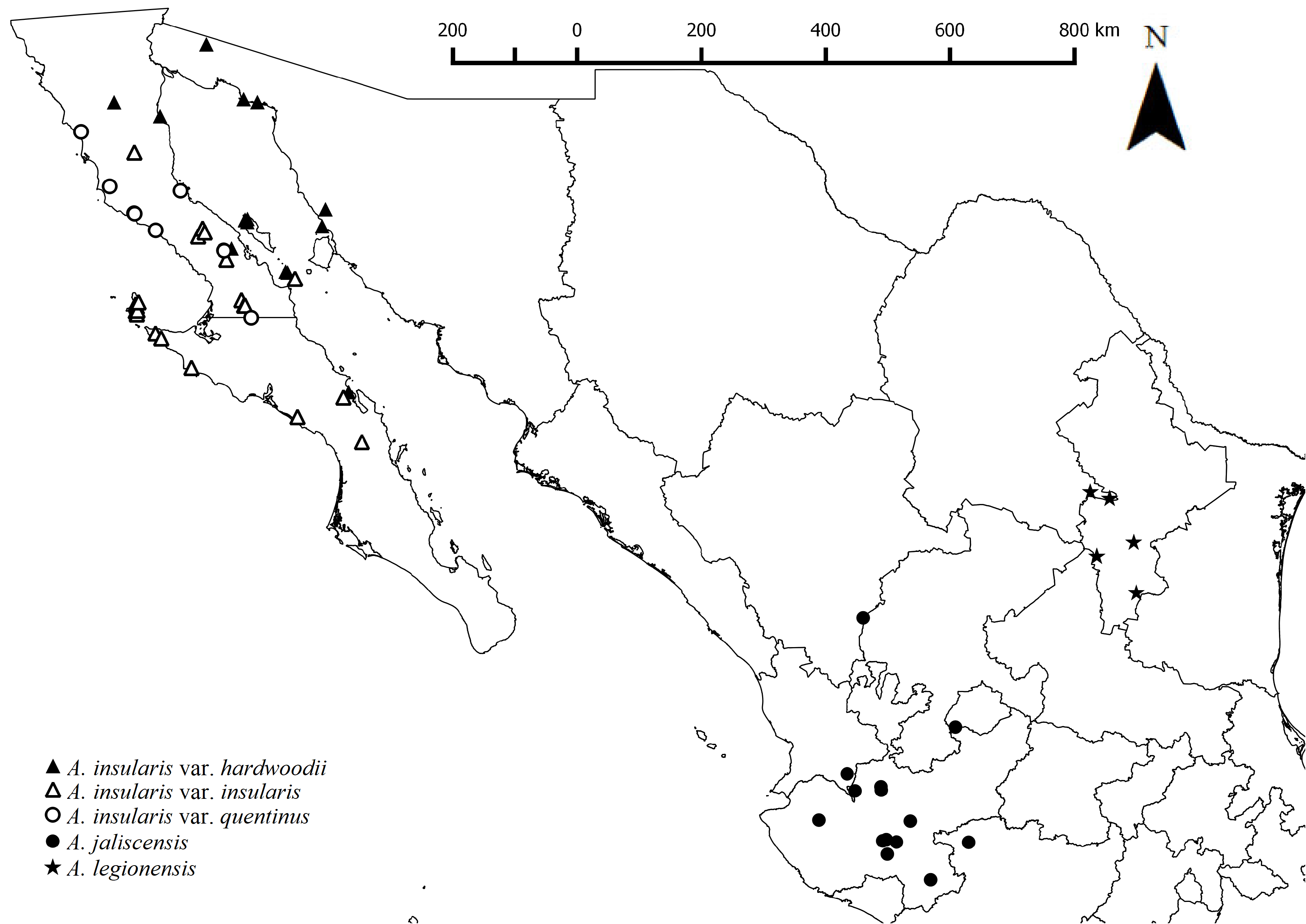
Distribution:— Northwestern Sonora (from San Luis Río Colorado, Altar Desert and Pinacate), south along the coast (from Puerto Peñasco, through Álvaro Obregón, Puerto Lobos, Puerto Libertad, Tordilla, Cabo Tepoca to Bahía Kino and San Clemente), in the Gulf of California, on the San Lorenzo Islands, Salsipuedes and Isla Angel de la Guarda. In Baja California, on the eastern coast between San Felipe and Estrella (30°56’– 31°01’N), on the peninsula, from the height from San José and Chapala (29°23’N – 29°31’N) to Punta Prieta, Juáez, Bachandres (28°50’N – 114° 03’W), and the western coast in Baja California Sur, between Santa Maria (27°24’N – 112°18’W) and Santa Rosalia (27°20’N – 112°18’W). Also, in Arizona and California ( USA) ( Fig. 14 View FIGURE 14 ).
Habitat:— Sandy, clayey and granite rock soils; gravelly and rolling sand plains; flood banks; beach sand; coastal plains with low dunes; associated to creosote bush scrub; associated with Joshua tree, prickly-pear, lomboy blanco, saltbush,wolfberry, creosotebush scrub; bottom of canyon; 1–1100 m.
Specimens examined:— BAJA CALIFORNIA: 22 March 1963, Summit of peak ca. 4 miles 4 miles SE of Refugio Bay, Isla Angel de la Guarda, R. Moran 10471 ( CAS, NY, US) ; 26 March 1960, 18 miles north of Punta Prieta ½ mile south of road to San Felipe, D. B. Wiggins 15972-A ( CAS) ; 17 March 1960, roadside 15 miles north of San Felipe, I. L. Wiggins, D. B. Wiggins 15786, 15788 ( CAS, MEXU) ; 26 March 1960, 2 miles northeast of junction of Gulf road with western road 20 miles north of Punta Prieta, I. L. Wiggins, D. B. Wiggins 15960-A ( CAS) ; 24 March 1962, San Lorenzo Island (southern island), I. l. Wiggins 17274 ( CAS) ; 20 April 1966, Isla Angel de la Guarda; summit of Cerro Angel, R. Moran 12922 ( CAS, NY, SD) ; 24 March 1962, North San Lorenzo Island, called Isla Partida, actually middle of three islands in the group, Gulf of California , I. L. Wiggins 17261 ( CAS) ; 17 March 1977, Isla Angel de la Guarda; en bajada, base oeste del pico, ca. 6.0 km al sureste de Puerto Refugio, R. Moran 23942 ( SD) ; 15 April 1947, Valle de Agua Amarga, a 15 millas al oeste de la Bahía de Los Ángeles , C. F. Harbison 41763 ( SD) ; IV-1905, Isla Cedros, T. S. Brandegee s.n. ( SD) ; 12 April 1963, 1.2 mile by road ( Mex. 15) north of Casita. Valley bottom, R. S. Felger 7219 ( MEXU) . BAJA CALIFORNIA SUR: 1 June 1973, About 10 mi. NW of Santa Rosalia, R. W. Spellenberg 3327, M. Spellenberg, H. Wolfe, J. Sylvester ( NY) ; 11 February1984, Desierto de Vizcaino , al E de Bahía Asunción, Mpio. Mulegé, J. Cancino 19c, C. Plata ( MEXU) . SONORA: 29 April 1991, Paved highway from Puerto Peñasco to Caborca, ca. 8.5 km northeastward from mouth of Estero Morúa (junction of road to Playa Encanto), R. S. Felger 91- 46 ( NY) ; 27 February1958, Cholla Bay , Punta Peñasco, P. H. Raven 11674 ( NY) , Northern limits of Peñasco , 11680 ( CAS, NY) ; 22 March 1978, 29 mi. by road S of Desemboque , about 5 mi. due W of new highway under construction, ca. 3 mi. E of rocky, reddish mountains, R. & M. Spellenberg 4949 ( NY) ; 16 March 1936, Playa 1 mi. inland from Punta Penasca, I. L. Wiggins 8383 ( CAS) ; 23 February1935, Along beach 24 miles south of Punta Prieta , I. L. Wiggins 7740B ( CAS) ; 7 March 1983, Coast of the Gulf of California near the mouth of the Rio Concepcion , 10.6 miles NE of El Desemboque on the road toward Caborca, A. C. Sanders 3476, M. Dimmitt, G. Montgomery et al. ( NY) ; 3 March 1972, R. S. Felger 20349 ( ENCB, SD) ; 31 March 1988, 8.2 km NE of Arroyo Batamote (crossing) on Mex. Hwy 8 (40 km SW of Sonoyta ), R. S. Felger 88-242 ( ENCB) ; 10 March 1973, ca. 2 miles north of Sierra del Rosario , Gran Desierto, R. S. Felger 20777 ( ENCB) .
48.2. Astragalus insularis Kellogg var. insularis
Type:— MEXICO, Baja California, Isla Cedros , 4 June 1877, J. A. Veatch (holotype: CAS not found: isotype: CAS 0001064 digital image!) .
Astragalus insularis Kellog, Bull. Calif. Acad. Sci. 1: 6: 1884. - Astragalus triflorus (DC.) A. Gray var. insularis (Kellog) M. E. Jones, Proc. Calif. Acad. Sci. II. View in CoL 5: 637. 1895. — Phaca insularis (Kellog) Rydb., N. Amer. Fl. 24: 353. 1929. — Astragalus insularis Kellog var. pondii M. E. Jones, Rev. N. -Amer. Astragalus 104. 1923.
Phaca pondii Rydb., N. Amer. Fl. 24(6): 351. 1929.
Distinctive characters as in the key.
Distribution:— Variety endemic to the peninsula of Baja California. More frequently distributed along the western coast of Baja California, from Mina Columbia (29°19’N) and Punta Prieta (28°57’N – 114°09’W), through Los Tepetates and Las Palomas (central-western portion of peninsula), also on Cedros and San Lorenzo islands. In Baja California Sur along western coast, from San Cristobal (27°24’N – 114°30’W), to the south, through de San Pablo, San Roque to El Batequi, San Juan and La Ballena (26°21’N – 112°35’W) ( Fig. 14 View FIGURE 14 ).
Habitat:— Volcanic rocks; boulder fields; sandy valleys floors; seasonally flooded valleys; eroding low coastal hills; seasonally; steep ravines; arid scrublands; sacrocaule scrub; rocky slopes with columnar cacti, wolfberry, and prickly-pear; associated with cirio (boojum), creosote bush, jojoba, mezquite, prickly-pear, wolfberry, saltbush, maguey; 6– 550 m.
Specimens examined:—BAJA CALIFORNIA: 11 March 1998, Desierto de Vizcaino; N de El Arco; N de Calmalli, a lo largo de la carretera entre Rancho Esperanza y Rancho Miramar , J. Rebman 4867 ( BCMEX; SD); 20 March 1966, Rancho Carrizo, R. Moran 12835 ( NY) ; 3 June 1925, Cedros Island, H. L. Mason 1994 ( CAS) ; 24 March 1962, San Lorenzo Island (southern island), Gulf of California I. L. Wiggins 17274 ( CAS, NY) ; 17 February 1962, 9 miles south of Higuera on road from Bahia de los Angeles to San Borja, I. L. Wiggins 16728 ( CAS, MEXU, US); 12 March 1911, Cedros Island, J. N. Rose 16151 ( NY) ; 18–20 March 1889, Cedros Island, E. Palmer 685 ( NY) ; 25 February 1935, 2 miles east of Rancho Mesquital, F. Shreve 6961 ( CAS) ; 19 March 2010, 24 km NW by air from turn off of Highway 1 to Bahia de los Angeles , B. T. Wilder 10-119, J. P. Rebman, I. Andrew Happle, S. I. Enciso ( CAS, USON, SD) ; 1 March 1985, 10–20 km N or Puerto Santa Catarina on road to Rancho Santa Catarina, D. E. Breedlove 62276 ( CAS, MEXU, NY, TEX-LL) ; 26 February1986, Near Punta Canoas, D. E. Breedlove 62490 ( CAS, ENCB, MEXU, NY, TEX-LL) ; 1 May 1970, 7 miles north of Jaraguay, R. R. Humphrey 2070 ( CAS, ENCB) ; 20 March 1960, 18 miles north of Punta Prieta ½ mile south of road to San Felipe, I. L. Wiggins 15972- A, D. B. Wiggins ( NY) ; 18 March 1939, Canyon southeast of Mount Cerros, Cedros Island, A. L. Haines n.n, G. Hale ( CAS, MEXU, NY, SD, TEX-LL) ; 20 March 1966, 10 miles north of San Borja, R. V. Moran 7960 ( NY) ; 24 March 1962, cerca del extremo S de la isla N San Lorenzo, R. Moran 8881 ( SD) ; 15 April 1963, Isla Cedros, NO del pueblo de Cedros , camino a la primavera, R. Moran 10619 ( SD) ; VIII-1931, Isla Cedros, G. Fleming n.n ( SD) ; 21 July 1939, Isla Cedros , L. M. Walker, n.n ( SD) ; 30 March 1978, Isla Cedros; Cañon Grande , R. Moran 25422 ( SD) ; 16 April 1963, Isla Cedros; en el lecho del arroyo en medio de la costa este, R. Moran 10685 ( SD) ; 21 July 1980, Isla Cedros, cerca del aeródromo al sur del pueblo, R. Moran 29066 ( SD) ; 24 March 1962, Lado suroeste de la isla sur de San Lorenzo , R. Moran 8900 ( NY, SD) ; 12 April 1983, Isla Cedros, lavar al norte de la ciudad, T. Oberbauer s.n., H. & E. Wier ( SD) ; 28 April 1987, 14 Km al SW de Cataviña, por la carr. Transpeninsular , P. Tenorio L. 13128, C. Romero de T. ( CFNL, MEXU) ; 7 April 1973, 5–6 miles S. of road to Bahia Los Angeles alog road to Mission San Borja, H. S. Gentry 23164 ( MEXU) ; 1 May 1987, Rancho El Potrero, 40 km al SW de el Observatorio de San Pedro Martir, P. Tenorio L. 13224, C. Romero de T. ( MEXU) ; 30 March 1977, C. 43 mi S of Cataviña, G. L. Webster 21716 ( MEXU) ; 20 April 1987, San Roque, P. Tenorio L. 12941, C. Romero de T. ( MEXU) ; 26 March 1970, ocassional in arroyo bed, ammonite area, Arroyo Santa Catarina, 5 miles N of the mouth, R. Moran 16939 ( ENCB) ; 27 February 1987, 8 km on Mex Hwy 8 north of Puerto Peñasco, at road junction to Bahia de La Choya, R. Felger 87-21 ( MEXU) . BAJA CALIFORNIA SUR: 14 February1973, Arroyo San José, R. Moran 20132, J. L. Reveal ( NY, US, SD); 5 February1972?, Arroyo 3 miles SE of San Andrés, R. Moran 19798 ( NY, US); 24 April 1989, Vizcaino Desert, plain S of Mesa Punta de Auras, 5 miles N of Bahia Asuncion on rd to San Jose del Castro , S. 3480, T. Ross, L. Arnseth ( MEXU, NY) ; 26 March 1982, Pacific slope of Sierra de Placeros 35 km SE of Bahia Tortugas, D. E. Breedlove 60941 ( NY) ; 7 March 1985, 35 km SE of Bahia Tortugas, pacific slope of Sierra de Placeros, D. E. Breedlove 62318 ( CAS, MEXU, NY, TEX-LL) ; 13 March 1911, San Bartolomé Bay, J. N. Rose 16195 ( NY) ; 14 March 1911, San Bartolomé Bay, J. N. Rose 16904 ( NY) ; 31 March 1978, Long trail above old copper mine, Cedros Island, V. Yadon 20 ( CAS) ; 21–23 March 1947, Las Tinajas and vicinity in cerros east of Los Picachos de Santa Clara, H. S. Gentry 7576 ( CAS) ; 10–15 March 1947, Eastern bajada of Sierra Calvario, Systema de Sierra Viscaino , H. S. Gentry 7514 ( CAS) ; 3 June 1925, Cedros Island, H. L. Mason 1994 ( CAS) ; 26 March 1984, Pacific slope of Sierra de Placeros 35 km SE of Bahia Tortugas, D. E. Breedlove 60941A ( CAS) ; 24 April 1989, Vizcaino Desert, plain S of Mesa Punta de Auras, 5 miles N of Bahia Asuncion on rd to San Jose del Castro , S. D. Boyd 3480 ( NY) ; 26 June 1983, Desierto del Vizcaino, Arroyo San José de Cassssstro, Mpio. Mulegé , J. Cancino H. 12 ( MEXU) ; 24 June 1977, Aguaje vargas, Isla Cedros , L.M. Villarreal P. 10628 ( ENCB) ; 23 April 1973, Cerro Pedregoso, El Mezquital , a orilla de la carretera, C. L. Díaz 4155 ( ENCB) . 21 April 1987, 12 Km al NE de Bahía Tortugas, brecha a Viscaino , P. Tenorio L. 12982. C. Romero de T. ( MEXU) ; III June 1897, Cedros Island, A. W. Anthony 303 ( CAS, MEXU, NY, SD) .
48.3. Astragalus insularis Kellog var quentinus M. E. Jones, Contr. W. Bot. 8: 6. 1898
Type:— MEXICO, Baja California, San Quintin, 12 April 1886, Orcutt 1327 (holotype: BM 000931689 digital image!: isotype: NY 00005805 !) .
This variety has a localized geographical distribution.
Distribution:— Endemic to Baja California, it is distributed from Vicente Guerrero and San Quintín (30°39’N – 115°32’W) south to San Carlos, Santa Catarina and Canoas (29°28’N – 115°11’W) ( Fig. 14 View FIGURE 14 ).
Habitats:— Silty soils with rocks; canyons along washes; dunes; slopes near roads; along beds of dry streams; slopes, next to intermittent streams, with Fouquieria , Pachycormus, Machaerocereus, Opuntia, Atriplex , Larrea, Trixis, Lophocereus , Yucca, Salvia, Solanum ; coastal scrub; 180– 210 m.
Specimens examined:— BAJA CALIFORNIA: 4 April 1998, Ca 0.6 millas S del camino a Bahía de los Ángeles y aprox. 17 millas al este de El Crucero y su cruce con la autopista 1, J. Rebman 5028 (BCMEX, SD); 9 April 1931, Norte Socoro canyon from sign post to beach, I. L. Wiggins 5217 (CAS); 29 March 1984, Ammonite Canyon at its junction with Arroyo Santa Catarina, 5.4 miles E of Santa Catarina Landing on the road to Rancho Santa C, A. C. Sanders 5555, E. Rodriguez, J. West et al. (NY); 10 April 1931, Rosario Wash, I. L. Wiggins 5244 (CAS, NY); I-1889, San Quentin Bay, E. Palmer 719 (CAS, NY); 24 February1938, Norte Camp 2 mi. S. of Mesquital, I. L. Wiggins 7767 (CAS); 10 January 1976, Highway 1 2 km south of San Martin, D. Johnson 149 (CAS); 22 April 1886, Plains near San Quentin bay, C. R. Orcutt 1327 (NY); 23 March 1970, Arroyo el Cuervito, cerca de la boca, R. Moran 17088 (SD).
| RSA |
RSA |
| CAS |
USA, California, San Francisco, California Academy of Sciences |
| MEXU |
MEXU |
| SUR |
SUR |
| BCMEX |
BCMEX |
| USON |
USON |
| CFNL |
CFNL |
| CAS |
California Academy of Sciences |
| NY |
William and Lynda Steere Herbarium of the New York Botanical Garden |
| MEXU |
Universidad Nacional Autónoma de México |
| SD |
San Diego Natural History Museum |
| ENCB |
Universidad de Autonoma de Baja California |
| BCMEX |
Universidad Autónoma de Baja California |
| USON |
Universidad de Sonora |
| CFNL |
Universidad Autónoma de Nuevo León |
No known copyright restrictions apply. See Agosti, D., Egloff, W., 2009. Taxonomic information exchange and copyright: the Plazi approach. BMC Research Notes 2009, 2:53 for further explanation.
|
Kingdom |
|
|
Phylum |
|
|
Class |
|
|
Order |
|
|
Family |
|
|
Genus |
Astragalus insularis Kellogg, Bull. Calif. Acad. Sci.
| Castillón, Eduardo Estrada, Quintanilla, José Ángel Villarreal, Delgado-Salinas, Alfonso & Rebman, Jon P. 2023 |
Astragalus triflorus (DC.) A. Gray var. insularis (Kellog) M. E. Jones, Proc. Calif. Acad. Sci. II.
| Kellog 1895: 637 |