
Leitoscoloplos acutus (Verrill, 1873)
|
publication ID |
https://doi.org/10.11646/zootaxa.4930.1.1 |
|
publication LSID |
lsid:zoobank.org:pub:97110C21-173C-4552-96AC-4B5DC987FF1C |
|
DOI |
https://doi.org/10.5281/zenodo.4677358 |
|
persistent identifier |
https://treatment.plazi.org/id/03C9912C-FFD4-FFB9-01A7-14F7FB8AFF44 |
|
treatment provided by |
Plazi |
|
scientific name |
Leitoscoloplos acutus (Verrill, 1873) |
| status |
|
Leitoscoloplos acutus (Verrill, 1873) View in CoL
Figures 1–3 View FIGURE 1 View FIGURE 2 View FIGURE 3
Anthosoma acutum Verrill, 1873: 305–306 .
Scoloplos acutus: Verrill 1881: 301 View in CoL , 305, 309; Procter 1933: 141, Fig. 32 View FIGURE 32 . Not Curtis 1969; Not Zhadan 1998.
Scoloplos armiger: Hartman 1944 View in CoL , pl. 18, fig. 5. Not O.F. Müller 1776.
Scoloplos ( Scoloplos) acutus: Pettibone 1963: 293–294 View in CoL , fig. 74g.
Leitoscoloplos acutus: Maciolek-Blake et al. 1985 View in CoL : B-5; Blake et al. 1998: C-1, C-2; Blake 2017: 18.
Scoloplos ( Leitoscoloplos) acutus: Trott View in CoL : 2004: 280.
Schroederella berkeleyi Laubier, 1971: 1483–1486 View in CoL , fig. 1. New synonymy.
Material examined. ( 2,726 specimens). Northeastern USA. Gulf of Maine, Damariscotta River Estuary, Lowes Cove, coll. J.A. Blake, 26 Jul 1967, 43°59.658′W, 69°33.255′W, intertidal (7, MCZ 161514 About MCZ ) ; West Side Seal Cove , coll. G. Noyes, 03 Aug 1966, 43°53.087′W, 69°34.147′W, 1–2 m (1, MCZ 161515 About MCZ ) ; Cove north of Wiley Point , coll. D. Dorsey and V. Walker, 15 Aug 1966, 43°59.063′W, 69°33.047′W, 1 m (5, MCZ 161516 About MCZ ) ; Oyster Creek , coll. D. Dorsey, 05 Aug 1966, 43°53.363′N, 69°30.615′W, 1–2 m (1, MCZ 161517 About MCZ ) GoogleMaps .— Connecticut, Long Island Sound, USACE Dredged Material Disposal Site Survey , Sta. NL 1KE, Rep. 2, 17 Feb 2000, 41°16.323′N, 72°03.877′W, 16 m (8, MCZ 161521 About MCZ ) GoogleMaps ; Rep. 3, 17 Feb 2000, 41°16.313′N, 72°03.894′W, 16 m (3, MCZ 161522 About MCZ ) GoogleMaps . Sta. NL 2KE, Rep. 1, 17 Feb 2000, 41°16.303′N, 72°03.143′W, 12 m (7, MCZ 161523 About MCZ ) GoogleMaps ; Rep. 2, 17 Feb 2000, 41°16.297′N, 72°03.155′W, 12 m (5, MCZ 161524 About MCZ ) GoogleMaps ; Rep. 3, 17 Feb 2000, 41°16.312′N, 72°03.154′W, 12 m (5, MCZ 161525 About MCZ ) GoogleMaps . Sta. NLLRF, Rep. 1, 17 Feb 2000, 41°16.688′N, 72°01.949′W, 16 m (8, MCZ 161526 About MCZ ) GoogleMaps ; Rep. 2, 17 Feb 2000, 41°16.710′N, 72°02.000′W, 16 (5, MCZ 161527 About MCZ ) GoogleMaps ; Rep. 3, 17 Feb 2000, 41°16.657′N, 72°01.908′W, 16 m (12, MCZ 161528 About MCZ ) GoogleMaps . Sta. NLRLC, Rep. 1, 17 Feb 2000, 41°16.504′N, 72°04.492′W, 14 m (1, MCZ 161529 About MCZ ) GoogleMaps ; Rep. 3, 17 Feb 2000, 41°16.425′N, 72°04.464′W, 14 m (2, MCZ 161530 About MCZ ) GoogleMaps . Sta. NLSEA, Rep. 2, 17 Feb 2000, 41°16.483’N, 72°04.887′W, 15 m (1, MCZ 161531 About MCZ ) GoogleMaps . Sta. WLW5H, Rep. 2, 19 Feb 2000, 40°59.265′N, 73°29.669′W, 34 m (1, MCZ 161532 About MCZ ) GoogleMaps .— Atlantic Ocean , off New Jersey, 14 Aug 2008; Excalibur Sta. 27B, 40°21.5148, 73°54.3525′W, 21 m (2, MCZ 161534 About MCZ ) .— Massachusetts, New Bedford Harbor, Long Term Monitoring Program , 1999 September–October Survey for USACE: Sta. 123, 29 Sep 1999, Rep. 1, 41°40.016′N, 70°55.034′W, 2.5 m (2, MCZ 161535 About MCZ ) GoogleMaps . Sta. 128, Rep. 1, 29 Sep 1999, 41°39.926′N, 70°55.041′W, 3 m (8, MCZ 161536 About MCZ ) GoogleMaps . Sta. 212, 24 Sep 1999, 41°38.826′W, 70°54.906′W, 3.3 m (132, MCZ 161537 About MCZ ) . Sta. 318, 10 Oct 1999, 41°35.664′N, 70°52.283′W, 6.6 m (2, MCZ 161538 About MCZ ) GoogleMaps . Sta. 331, 15 Sep 1999, 41°34.198′N, 70°55.707′W, 7.3 m (2, MCZ 161539 About MCZ ) GoogleMaps .— Massachusetts, Duxbury Bay , coll. J.A. Blake, 02 Aug 1981, 42°2.15′N, 70°40.06′W, low intertidal (10, MCZ 161533 About MCZ ) GoogleMaps .— Massachusetts Bay, MWRA Harbor and Outfall Monitoring Program . 1992 May Survey: Sta. FF-4, 42°17.30′N, 70°25.49′W, 92 m (65, MCZ 161400 About MCZ ) GoogleMaps . Sta. FF-5, 42°08.00′N, 70°25.35′W, 64 m (5, MCZ 161401 About MCZ ) GoogleMaps . Sta. FF-9, 42°18.75′N, 70°39.40′W, 51 m (25, MCZ 161402 About MCZ ) GoogleMaps . Sta. WH3, 42°23,39′N, 70°49.84′W, 36 m (292, MCZ 161403 About MCZ ) GoogleMaps . 1992 August Survey : Sta. NF-1, 42°20.35′N, 70°50.51′W, 42 m (5, MCZ 161404 About MCZ ) GoogleMaps ; Sta. NF-2, 42°20.31′N, 70°49.69′W, 26 m, (4, MCZ 161405 About MCZ ) GoogleMaps . Sta. NF-5, 40°25.62′N, 70°50.03′W, 28 m (4, MCZ 161406 About MCZ ) GoogleMaps . Sta. NF-7, 42°24.60′N, 70°48.89′W, 32 m (33, MCZ 161407 About MCZ ) GoogleMaps ; Sta. NF-8, 42°24.00′N, 70°51.81′W, 28 m (5, MCZ 161408 About MCZ ) GoogleMaps . Sta. NF-11, 42°23.39′N, 70°50.25′W, 31 m (23, MCZ 161409 About MCZ ) GoogleMaps . Sta. NF-12, 42°23.40′N, 70°49.83′W, 33 m (33, MCZ 161410 About MCZ ) GoogleMaps . Sta. NF-13, 42°23.40′N, 70°49.35′W, 33 (1, MCZ 161411 About MCZ ) GoogleMaps . Sta. NF-14, 42°23.20′N, 70°49.36′W, 32 m (13, MCZ 161412 About MCZ ) GoogleMaps ; Sta. NF-1 5, 42°22.93′N, 70°49.67′W, 32 m (17, MCZ 161413 About MCZ ) GoogleMaps . Sta. NF-16, 42°22.70′N, 70°50.26′W, 29 m (31, MCZ 161414 About MCZ ) GoogleMaps . Sta. NF-19, 42° 22.30’N 70° 48.30’7W, 32 m (23, MCZ 161415 About MCZ ) . Sta. NF-20, 42°22.69′N, 70°50.69′W, 27 m (10, MCZ 161416 About MCZ ) GoogleMaps . Sta. FF-1, Rep. 2, 42°27.94′N, 70°37.31′W, 68 m (5, MCZ 161417 About MCZ ) GoogleMaps . Sta. FF-4, Rep. 1, 42°17.30′N, 70°25.50′W, 86 m (7, MCZ 161418 About MCZ ) GoogleMaps ; Rep. 2, (5, MCZ 161419 About MCZ ) . Sta. FF-5, Rep. 1, 42°08.00′N, 70°25.35′W, 61 m (10, MCZ 161420 About MCZ ) GoogleMaps ; Rep. 3, (5, MCZ 161421 About MCZ ) . Sta. FF-6, Rep. 1, 41°53.90′N, 70°24.20′W, 33 m (2, MCZ 161422 About MCZ ) GoogleMaps ; Rep. 2 (2, MCZ 161423 About MCZ ) ; Rep. 3 (4, MCZ 161424 About MCZ ) . Sta. FF-7, Rep. 3, 41°57.50′N, 70°16.00′W, 37 m (1, MCZ 161425 About MCZ ) GoogleMaps . Sta. FF-9, Rep. 1, 42°18.75′N, 70°39.40′W, 48 m (14, MCZ 161426 About MCZ ) GoogleMaps . Sta. FF-10, Rep. 1, 42°24.84′N, 70°52.72′W, 27 m (45, MCZ 161427 About MCZ ) GoogleMaps ; Rep. 2 (30+, MCZ 161428 About MCZ ) ; Rep. 3 (53, MCZ 161429 About MCZ ) . Sta. FF-11, Rep. 1, 42°39.50′N, 70°30.00′W, 86 m (4, MCZ 161430 About MCZ ) GoogleMaps ; Rep. 2 (2, MCZ 161431 About MCZ ) . Sta. FF-12, Rep. 1, 42°23.40′N, 70°53.98′W, 22 m (67, MCZ 161432 About MCZ ) GoogleMaps ; Rep. 2 (65, MCZ 161433 About MCZ ) , Sta. FF-13, Rep. 1, 42°19.19′N, 70°49.38′W, 19 m (2, MCZ 161434 About MCZ ) GoogleMaps ; Rep. 2 (2, MCZ 161435 About MCZ ) ; Rep. 3 (23, MCZ 161436 About MCZ ) . Sta. FF-14, Rep. 1, 42°25.00′N, 70°39.29′W, 69 m (4, MCZ 161437 About MCZ ) GoogleMaps ; Rep. 2 (2, MCZ 161438 About MCZ ) ; Rep. 3 (15, MCZ 161439 About MCZ ) . 1995 August Survey : Sta. FF-1A, 42°33.84′N, 70°40.55′W, 32 m (10, MCZ 161440 About MCZ ) GoogleMaps . Sta. FF-4, 42°17.30′N, 70°25.50′W, 87 m (~20, MCZ 161441 About MCZ ) GoogleMaps . Sta. FF-9, 42°18.75′N, 70°39.40′W, 49 m (31, MCZ 161442 About MCZ ) GoogleMaps . Sta. FF-10, 42°24.84′N, 70°52.72′W, 27 m (50+, MCZ 161443 About MCZ ) GoogleMaps . Sta. FF-11, 42°39.50′N, 70°30.00′W, 87 m (37, MCZ 161444 About MCZ ) GoogleMaps . Sta. FF-12, 42°23.40′N, 70°53.98′W, 22 m (25+, MCZ 161445 About MCZ ) GoogleMaps ; Sta. FF-13, Rep. 1, 42°19.19′N, 70°49.38′W, 19 m (50+, MCZ 161446 About MCZ ) GoogleMaps . Sta. FF-14, 42°25.00′N, 70°39.29′W, 77 m (40, MCZ 161447 About MCZ ) GoogleMaps . 1996 August Survey : Sta. NF-14, 42°23.20′N, 70°49.36′W, 33 m (7, MCZ 161448 About MCZ ) GoogleMaps . Sta. NF-15, 42°22.93′N, 70°49.67′W, 32 m (10, MCZ 161449 About MCZ ) GoogleMaps ; Sta. NF-18, 42°23.80′N, 70°49.31′W, 35 m (7, MCZ 161450 About MCZ ) GoogleMaps . Sta. NF-19, 42°22.30′N, 70°48.30′W, 32 m (5, MCZ 161451 About MCZ ) GoogleMaps . Sta. NF-24, Rep. 1, 42°22.83′N, 70°48.10′W, 37 m, (27, MCZ 161452 About MCZ ) GoogleMaps ; Rep. 2 (22, MCZ 161453 About MCZ ) ; Rep. 3 (35, MCZ 161454 About MCZ ) . Sta. MF-2, 42°20.31′N, 70°49.69′W, 30 m (27, MCZ 161455 About MCZ ) GoogleMaps . Sta. MF-5, 42°25.62′N, 70°50.03′W, 36 m (6, MCZ 161456 About MCZ ) GoogleMaps . Sta. MF-7, 42°24.60′N, 70°48.89′W, 33 m (17, MCZ 161457 About MCZ ) GoogleMaps . Sta. MF-8, 42°24.00′N, 70°51.81′W, 30 m (53, MCZ 161458 About MCZ ) GoogleMaps . Sta. MF-9, 42°23.99′N, 70°50.69′W, 29 m (42, MCZ 161459 About MCZ ) GoogleMaps .
Sta. MF-10, 42°23.57′N, 70°50.29′W, 35 m (38, MCZ 161460 About MCZ ). Sta. MF-12, Rep. 1 GoogleMaps , 42°23.40′N, 70°49.83′W, 34 m (37, MCZ 161461 About MCZ ); Rep. 2 (31, MCZ 161462 About MCZ ); Rep. 3 (39, MCZ 161463 About MCZ ). Sta. MF-16 GoogleMaps , 42°22.70′N, 70°50.26′W, 29 m (14, MCZ 161464 About MCZ ). Sta. MF-20 GoogleMaps , 42°22.69′N, 70°50.69′W, 28 m (35, MCZ 161465 About MCZ ). Sta. MF-21 GoogleMaps , 42°24.16′N, 70°50.19′W, 33 m (22, MCZ 161466 About MCZ ). Sta. MF-22 GoogleMaps , 42°20.87′N, 70°48.90′W, 36 m (22, MCZ 161467 About MCZ ). Sta. FF-1A, Rep. 1 GoogleMaps , 42°33.84′N, 70°40.55′W, 32 m (2, MCZ 161468 About MCZ ); Rep. 2 (3, MCZ 161469 About MCZ ); Rep. 3 (15, MCZ 161470 About MCZ ). Sta. FF-4, Rep. 1 GoogleMaps , 42°17.30′N, 70°25.50′W, 87 m (7, MCZ 161471 About MCZ ); Rep. 2 (6, MCZ 161472 About MCZ ); Rep. 3 (3, MCZ 161473 About MCZ ). Sta. FF-5, Rep. 1 GoogleMaps , 42°08.00′N, 70°25.35′W, 61 m (13, MCZ 161474 About MCZ ); Rep. 2 (3, MCZ 161475 About MCZ ); Rep. 3 (7, MCZ 161476 About MCZ ). Sta. FF-9, Rep. 1 GoogleMaps , 42°18.75′N, 70°39.40′W, 49 m (5, MCZ 161477 About MCZ ); Rep. 2 (3, MCZ 161478 About MCZ ); Rep. 3 (8, MCZ 161479 About MCZ ). Sta. FF-10, Rep. 1 GoogleMaps , 42°24.84′N, 70°52.72′W, 27 m (41, MCZ 161480 About MCZ ); Rep. 2 (28, MCZ 161481 About MCZ ); Rep. 3 (35, MCZ 161482 About MCZ ). Sta. FF-11, Rep. 1 GoogleMaps , 42°39.50′N, 70°30.00′W, 87 m, (3, MCZ 161483 About MCZ ); Rep. 2, (10, MCZ 161484 About MCZ ); Rep. 3, (10, MCZ 161485 About MCZ ). Sta. FF-12, Rep. 1 GoogleMaps , 42°23.40′N, 70°53.98′W, 22 m, (56, MCZ 161486 About MCZ ); Rep. 2, (44, MCZ 161487 About MCZ ); Rep. 3 (40, MCZ 161488 About MCZ ). Sta. FF-13, Rep. 1 GoogleMaps , 42°19.19′N, 70°49.38′W, 19 m (83, MCZ 161489 About MCZ ); Rep. 2 (38, MCZ 161490 About MCZ ); Rep. 3 (116, MCZ 161491 About MCZ ). Sta. FF-14, Rep. 1 GoogleMaps , 42°25.00′N, 70°39.29′W, 77 m (6, MCZ 161492 About MCZ ); Rep. 2 (15, MCZ 161493 About MCZ ); Rep. 3 (13, MCZ 161494 About MCZ ). 1997 August GoogleMaps Survey : Sta. MF- 2 , 42°20.31′N, 70°49.69′W, 30 m (2, MCZ 161495 About MCZ ). Sta. MF-5 GoogleMaps , 42° 25.62′N, 70° 50.03′W, 36 m (4, MCZ 161496 About MCZ ). Sta. MF-9 GoogleMaps , 42°23.99′N, 70°50.69′W, 29 m (22, MCZ 161497 About MCZ ). Sta. MF-10 GoogleMaps , 42°23.97′N, 70°50.29′W, 35 m (34, MCZ 161498 About MCZ ). Sta. MF-12, Rep. 1 GoogleMaps , 42°23.40′N, 70°49.83′W, 34 m (20, MCZ 161499 About MCZ ); Rep. 2 (32, MCZ 161500 About MCZ ); Rep. 3 (40, MCZ 161501 About MCZ ). Sta. MF-16 GoogleMaps , 42°22.70′N, 70°50.26′W, 29 m (32, MCZ 161502 About MCZ ). Sta. MF-20 GoogleMaps , 42°22.69′N, 70°50.69′W, 28 m ( 19, MCZ 161503 About MCZ ). Sta. MF-21 GoogleMaps , 42°24.16′N, 70°50.19′W, 33 m (13, MCZ 161504 About MCZ ). Sta. MF-22 GoogleMaps , 42°20.87′N, 70°48.90′W, 36 m (38, MCZ 161505 About MCZ ). Sta. FF-9, Rep. 1 GoogleMaps , 42°18.75′N, 70°39.40′W, 49 m (3, MCZ 161506 About MCZ ); Rep. 2 (5, MCZ 161507 About MCZ ); Rep. 3 (4, MCZ 161508 About MCZ ). Sta. FF-10, Rep. 1 GoogleMaps , 42°24.84′N, 70° 52.72′W, 27 m (9, MCZ 161509 About MCZ ); Rep. 2 (46, MCZ 161510 About MCZ ). Sta. FF-12, Rep. 1 GoogleMaps , 42°23.40′N, 70°53.98′W, 22 m (50, MCZ 161511 About MCZ ); Rep. 2 (32, MCZ 161512 About MCZ ); Rep. 3 (34, MCZ 161513 About MCZ ).— Off Massachusetts, Georges Bank, MMS Benthic Infauna Monitoring Program, coll. G.W. Hampson, Chief Scientist. Sta. 11: Cruise M 4, Rep 1, 16 May 1982 GoogleMaps , 40°30.8′N, 68°33.7′W, 83 m (2, USNM 1620840 About USNM ); Cruise M 5, Rep. 2, 28 Jul 1982 GoogleMaps , 40°30.8′N, 68°33.7′W, 77 m (2, USNM 1620841 About USNM ); Cruise M 6, Rep. 5, 26 Nov 1982 GoogleMaps , 40°30.8′N, 68°33.7′W, 83 m (1, USNM 1620842 About USNM ); Cruise M 11, Rep. 1, 02 Feb 1984 GoogleMaps , 40°30.8′N, 68°33.7′W, 86 m (1, USNM 1620843 About USNM ); Rep. 3 (3, USNM 1620844 About USNM ). Sta. 13: Cruise M 1, Rep. 4, Jul 1981 GoogleMaps , 40°29.5′N, 70°12.6′W, 65 m (1, USNM 1620845 About USNM ); Cruise M 2, Rep. 3, 9 Nov 1981 GoogleMaps , 40°29.2′N, 70°12.4′W, 60 m (2, USNM 1620846 About USNM ); Cruise M 3, Rep. 1, 11 Feb 1982 GoogleMaps , 40°29.2′N, 70°12.4′W, 69 m (1, USNM 1620847 About USNM ); Rep. 5 (1, USNM 1620848 About USNM ); Cruise M 5, Rep. 5, 28 Jul 1982 GoogleMaps , 40°29.5′N, 70°12.6′W, 62 m (1, USNM 1620849 About USNM ); Cruise M 6, Rep. 5, 27 Nov 1982 GoogleMaps , 40°29.3′N, 70°12.4′W, 67 m (1, USNM 1620850 About USNM ); Rep. 6 (1, USNM 1620851 About USNM ); Cruise M 8, Rep. 1, 21 May 1983 GoogleMaps , 40°29.3′N, 70°12.5′W, 70 m (1, USNM 1620852 About USNM ); Cruise M 12, Rep. 1, 03 Jun 1984 GoogleMaps , 40°29.5′N, 70°12.6′W, 70 m (1, USNM1620853 About USNM ). Sta. 18: Cruise M 3, Rep. 6, 18 Feb 1982 GoogleMaps , 40°33.5′N, 67°13.7′W, 145 m (8, USNM 1620854 About USNM ) GoogleMaps .
Other material examined. Massachusetts, Craigsville Beach, Centerville , Barnstable County, coll. W.J. Wall, 26 Jun 1969, intertidal, holotype of Schroederella berkeleyi Laubier, 1971 ( USNM 44946 About USNM ) .
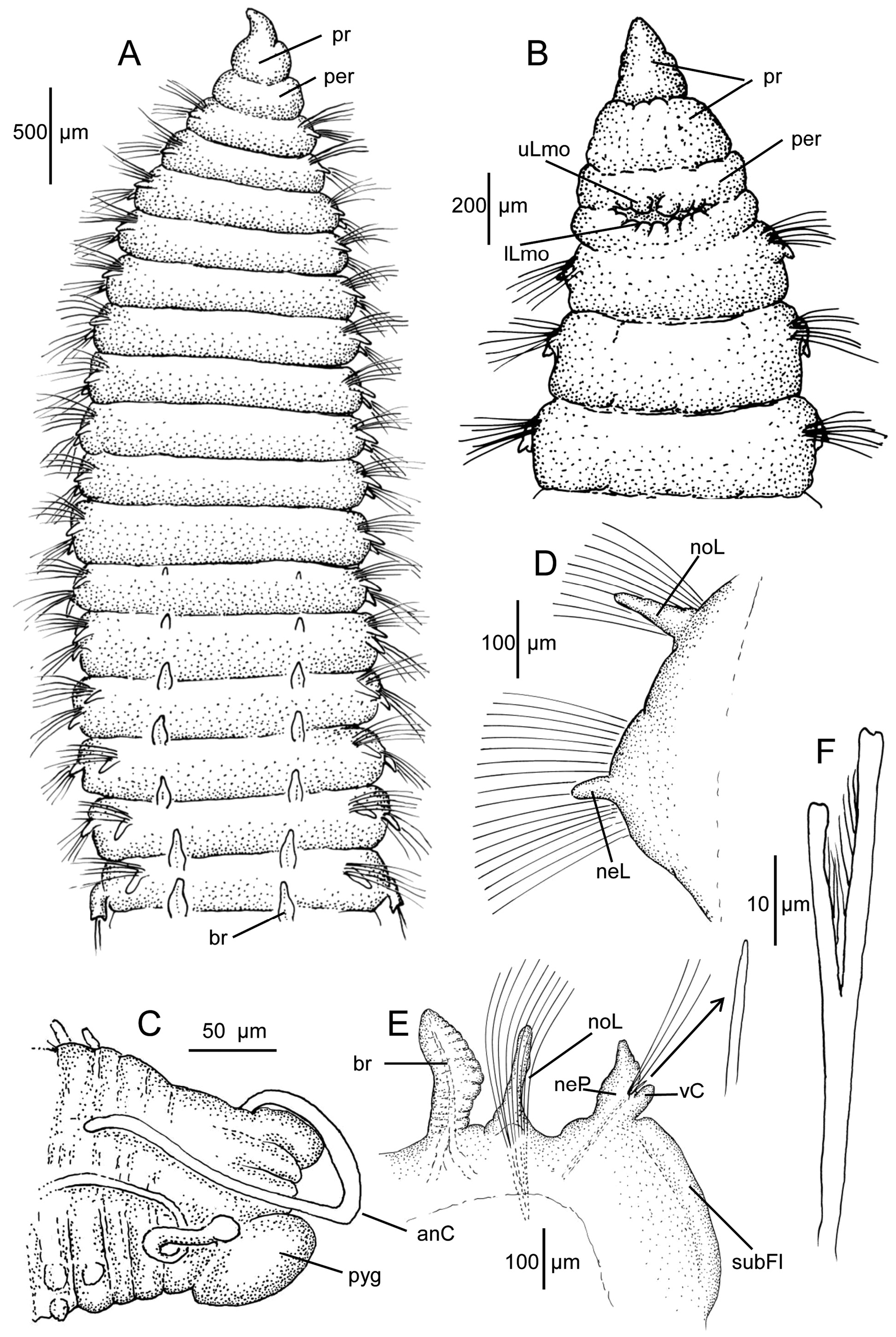
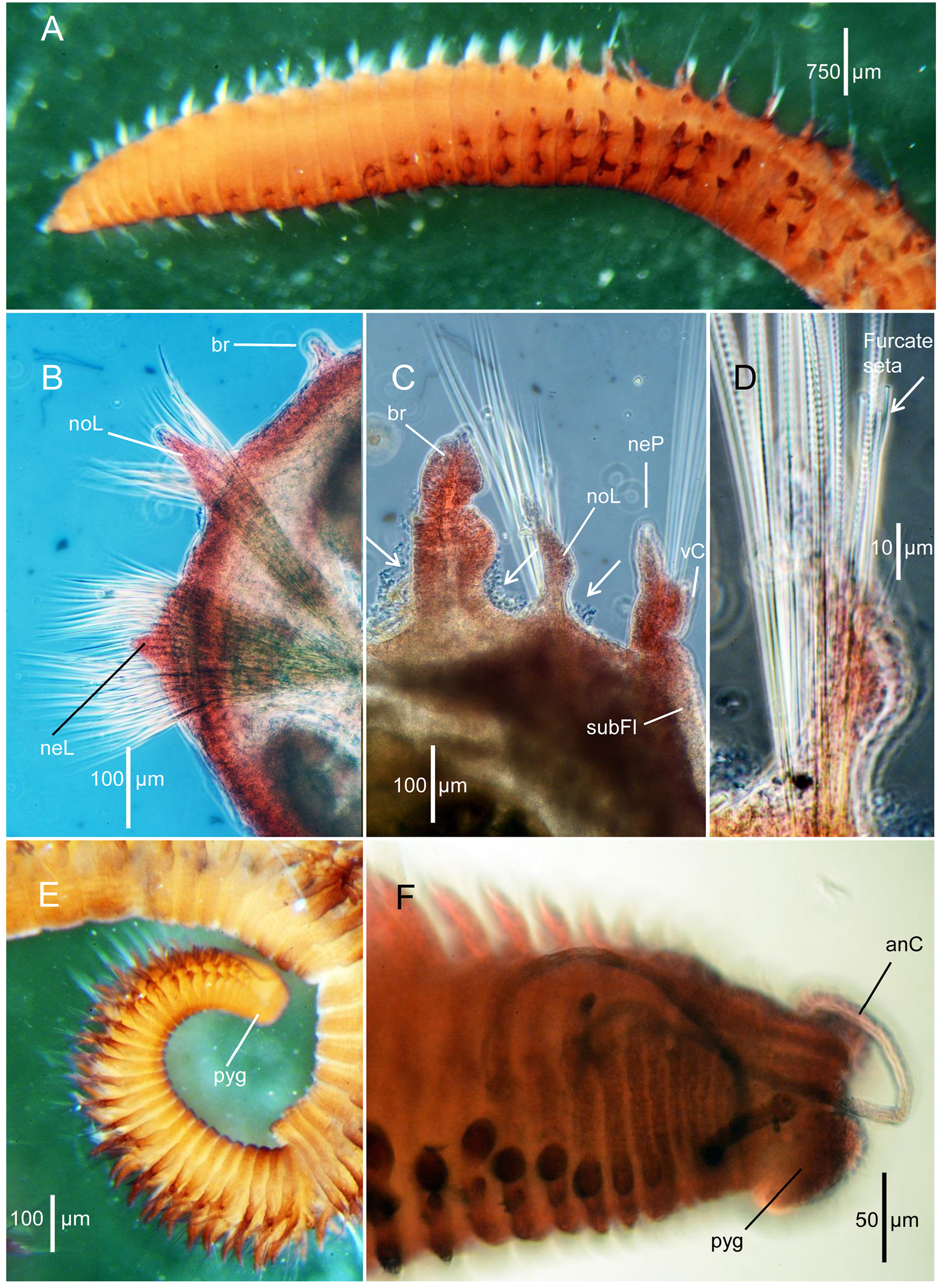
Description. A moderate-sized species, typically about 20–22 mm long with 75–80 setigers; specimen from Georges Bank (USNM 1620847) complete, long and narrow, with 125 setigers, 25 mm long and about 1.5 mm wide across middle of thorax; recorded up to 40 mm long by Pettibone (1963). Body elongate, with thoracic region dorsoventrally flattened, with individual segments short and narrow, 6–8 times wider than long ( Figs. 1A View FIGURE 1 , 2A View FIGURE 2 ); individual segments separated by narrow transverse groove. Abdominal segments also narrow, crowded without obvious annulations; posterior segments crowded ( Fig. 2E View FIGURE 2 ). Body with no longitudinal grooves or ridges; abdominal segments with a light-colored thin line along venter. Color in alcohol light tan.
Pre-setiger region triangular, relatively short, about as long as first two or three setigers. Prostomium thickened basally, narrowing to pointed apex ( Fig. 1 View FIGURE 1 A–B); nuchal organs oval slits on posterior lateral margin; eyespots absent. Peristomium a single short smooth achaetous ring ( Fig. 1A View FIGURE 1 ), weakly divided ventrally due to upper and lower lips of mouth. Upper lip of mouth with two rounded medial lobes and 2–3 smaller lateral lobes ( Fig. 1B View FIGURE 1 ); lower lip of mouth bordered with about 7–8 smaller lobes ( Fig. 1B View FIGURE 1 ). Proboscis when everted with 1–3 lobes.
Thorax with 14–16 setigers with abrupt transition to abdominal segments ( Figs. 1A View FIGURE 1 , 2A View FIGURE 2 ). Boundary between thorax and abdomen best observed by elongation of neuropodia and decrease in number of neurosetae. Thoracic notopodial lobes more or less triangular in shape, digitiform, narrowing apically arising from narrow base ( Figs. 1D View FIGURE 1 , 2B View FIGURE 2 ); neuropodial lobes also digitiform, shorter than notopodial lobe, arising from broadly rounded base ( Figs. 1D View FIGURE 1 , 2B View FIGURE 2 ). Abdominal notopodia elongate, narrow, digitiform ( Figs. 1E View FIGURE 1 , 2C View FIGURE 2 ). Abdominal neuropodia thickened, becoming relatively short in middle and posterior segments, each narrowing to pointed apical lobe and with subterminal ventral cirrus on lateral margin ( Figs. 1E View FIGURE 1 , 2C View FIGURE 2 ); with elongate, narrow subterminal flange ventral to neuropodium; subpodial papillae absent ( Figs. 1E View FIGURE 1 , 2C View FIGURE 2 ). Interramal cirrus or protuberance entirely absent.
Branchiae typically from setiger 10–13, initially thoracic branchiae small and short, becoming full size by about setigers 14–15 ( Fig. 1A View FIGURE 1 ). Anterior branchiae triangular, tapering to rounded apex; branchiae of abdominal segments becoming weakly asymmetrical with bulge on inner margin ( Figs. 1E View FIGURE 1 , 2C View FIGURE 2 ); each branchia with transverse folds and cilia on inner margin ( Fig. 2C View FIGURE 2 , arrows).
Notosetae including camerated capillaries and furcate setae; up to 20–30 capillaries in 2–3 irregular rows in thoracic notopodia or largest specimens reduced to 10–15 long, thin capillaries in abdominal segments accompanied by 1–3 furcate setae ( Fig. 2D View FIGURE 2 ). Thoracic neurosetae all capillaries with about 45–55 setae in 4–5 rows; abdominal neurosetae including 2–7 capillaries with barbs along one edge and 1–2 short protruding aciculae, these minute, with rounded apex ( Fig. 1E View FIGURE 1 inset). Furcate setae of abdominal notopodia with unequal tynes, each tyne with a flattened rounded apex within which an opening and narrow channel can be observed with light microscope; narrow elongate fibrils present between tynes ( Fig. 1F View FIGURE 1 ); flail setae absent.
Pygidium with lateral, dorsal, and ventral lobes surrounding anal opening; with two long, thin anal cirri arising dorsolateral ( Figs. 1C View FIGURE 1 , 2F View FIGURE 2 ).
Variability. Apart from small juveniles, the morphology presented here is consistent over the range of sizes considered to represent adults. In the very largest specimens, however, a rounded, rudimentary subpodial flange may be present on the last thoracic setiger and/or the first abdominal setiger. This rudimentary flange transitions into the larger subpodial flange that develops on anterior abdominal segments and that continues on all abdominal neuropodia.
Juvenile morphology. Juveniles of this species that were present with the adults were initially thought to be similar to Schroederella berkeleyi Laubier, 1971 , a species established for small meiofaunal orbiniids from an intertidal sand beach in Massachusetts (Laubier 1971). However, examination of the holotype of S. berkeleyi and numerous juveniles in the new collections suggests that the juveniles represent part of a growth sequence for Leitoscoloplos acutus . Juveniles from Massachusetts Bay (MCZ 161433, MCZ 161464, and MCZ 161511) were examined in detail.
Specimens elongate, usually coiled in preservation and somewhat contracted ( Fig. 3 View FIGURE 3 A–E). Complete specimens ranged from 2.1 mm long with 21 setigers ( Fig. 3A View FIGURE 3 ) to 3.7 mm long with 48 setigers ( Fig. 3F View FIGURE 3 ); posterior pre-pygidial segments crowded due to active growth zone. Thoracic setigers through middle abdominal setigers all about same width, narrowing in far posterior segments. Color white to light tan.
Prostomium long, triangular, acutely pointed; eyespots absent; nuchal organs not observed. Peristomium with a single achaetous ring vaguely separated laterally and ventrally by weakly developed lines, but not into two separate rings. Anterior lip of mouth with two large lobes; posterior lip with five or six small lobes forming a posterior border.
Thorax with 7–9 setigers in smallest juveniles (21–28 setigers and 2.1–2.5 mm long); thorax with 11–13 setigers in larger juveniles (40–48 setigers and 3.0– 3.7 mm long); thoracic setigers each shorter than abdominal segments. Branchiae from setigers 10–11, short, minute at first, becoming longer in anterior abdominal segments. Thoracic notopodia initially short, papillate, increasing in length, becoming digitiform by about setiger 6–7; abdominal notopodia long and narrow. Thoracic neuropodia initially papillate, becoming longer and digitiform by about setigers 7–8; abdominal neuropodia with thickened base, apically separated into two lobes, initially equivalent in size and shape; larger juveniles with inner lobe becoming longer as in adults. Neuropodia with short, narrow subpodial flange with smooth border. Subpodial papillae and interramal cirri absent.
Thoracic notosetae of small juveniles with 4–6 camerated capillaries in a single row, increasing to about 15–16 capillaries in larger juveniles, most in one row, a few in a second posterior row; abdominal notosetae 3–4 camerated capillaries; furcate setae observed only on larger 45–48-setiger juveniles in far posterior segments. Thoracic neurosetae consisting of 12–15 capillaries arranged in two rows, increasing to 20–25 capillaries in two rows in larger juveniles. Abdominal neurosetae with 2–3 capillaries, these smooth, barbs not observed; a short, thin, sharply pointed acicula present.
Pygidium with two anal cirri; short and thick in small juveniles ( Fig. 3 View FIGURE 3 C–D), long and thin in 40-setiger juveniles ( Fig. 3E View FIGURE 3 ).
Remarks. Leitoscoloplos acutus , although first described by Verrill (1873) from Vineyard Sound, has never been fully described and illustrated from New England waters. The present paper is the first to provide such detail for the species. The species is common and typically found in sediments with mixed sand and silt.
Leitoscoloplos acutus is most similar to L. pugettensis (Pettibone, 1957) , a widely distributed species along the North American Pacific coast from British Columbia to Central America (Mackie 1987; Blake 1996; Dean & Blake 2015). Both species lack extra subpodial lobes or papillae and have a prominent subpodial flange ventral to the abdominal neuropodia. L. pugettensis , however, although similar, is a much larger species, up to 200 mm long and with more than 200 setigers. The largest specimens of L. acutus , in contrast, are about 40 mm long with ca. 150 setigers; the largest specimens in the present study (more than 2700 specimens) are about 25 mm long with 125 setigers. The number of thoracic setigers in L. pugettensis is 14–20 with branchiae from setigers 13–18 or the penultimate segment based number of thoracic setigers; whereas in L. acutus , the number of thoracic setigers ranges from 14–16 with the branchiae occurring more anteriorly from setigers 9–13.
Curtis (1969), working in the Canadian Arctic (Ellesmere Island, 81°N), evaluated a growth sequence of speci- mens of Scoloplos collected at depth of 10 m. He provided data suggesting that Leitoscoloplos acutus represented a developmental phase of S. armiger where neuropodial uncini and subpodial papillae were entirely absent in small specimens having a width of 0.5 mm and fully present in specimens with a width of 2 mm; intermediate sizes had differing stages in the acquisition of these characters. However, there was no descriptive data provided to confirm the identity of either species he studied and given the much greater diversity of orbiniids recently revealed, it is unlikely that Curtis (1969) was dealing with either L. acutus or S. armiger .
There were hundreds of juveniles present in the collections due to the use of 300-µm-mesh sieves in the offshore monitoring surveys. Examination of juvenile morphology of various sizes confirmed a consistent agreement with the adults. Although a full growth sequence has not been developed, the samples are archived and available if such an analysis is required in the future. As part of the examination of juveniles, a comparison with the holotype of Schroederella berkeleyi suggests that the specimen agrees with juveniles of Leitoscoloplos acutus and is here referred to synonymy. There is nothing in the original account of S. berkeleyi that sets it aside as either a separate genus or species within the Orbiniidae . It should be noted that the only other possible synonyms locally would be either L. fragilis or L. robustus . However, none of the juveniles of L. acutus exhibit interramal cirri/processes or subpodial papillae which have been observed on smaller specimens of those species (see account of juvenile morphology for L. fragilis , below).
Zhadan (1998) reported two Scoloplos species from the White Sea, North Sea, Barents Sea, and East Greenland as S. armiger , the type species of the genus, and S. acutus previously known only from North America. Zhadan based her identification of S. acutus on observations that smaller specimens (< 1.75 mm wide) lacked hooks or uncini in thoracic neuropodia and subpodial papillae in posterior thoracic and abdominal neuropodia, whereas specimens larger than 1.75 mm wide had these characters. However, she did not have a full size range of specimens from the type locality in New England ( USA). In the present study no specimens were found with either thoracic uncini or subpodial papillae in the neuropodia at any stage of development and are thus referred to the genus Leitoscoloplos . A comparison of these U.S. Atlantic specimens of L. acutus with Scoloplos verrilli n. sp., the only local New England species of Scoloplos having characteristics similar to the larger S. acutus specimens reported by Zhadan (1998), indicates that her specimens represent a different species. Leitoscoloplos actus reported here have a long, smooth subpodial neuropodial flange on abdominal segments; in contrast, S. verrilli n. sp. has a short glandular neuropodial flange. Further, specimens of S. verrilli n. sp. that are smaller than the largest specimens of L. acutus have both thoracic neuropodial uncini and neuropodial subpodial papillae. Recent investigations of S. armiger from the North Sea have shown that shallow and subtidal populations are both ecologically and reproductively isolated from one another (Kruse & Reise 2003; Kruse et al. 2003, 2004). Results from molecular sequence data support these observations that shallow and subtidal North Sea populations likely represent separate species ( Bleidorn et al. 2006). Additionally, these authors determined that Norwegian specimens from near the type locality of S. armiger represented yet a third species. To date, these three taxa have not been described or compared with regard to their morphology.
Biology. Mature females of Leitoscoloplos acutus with internal eggs of various sizes arranged segmentally in middle abdominal setigers were collected in May 1992 in Massachusetts Bay, suggesting a late spring spawning. Adult females 25 mm long and 1.5 mm wide from Station FF-4 (MCZ 161400) had large eggs that ranged from 106 to 204 µm in diameter. The eggs have a smooth cytoplasm and clear germinal vesicle. These data suggest that mature eggs will likely exceed 210 µm in diameter, indicating direct development or a brief lecithotrophic larval development similar to that of the related species L. pugettensis (Pettibone, 1957) reported by Blake (1980) from California.
Sediment grain size at stations 11 and 13 on Georges Bank, where Leitoscoloplos acutus was most prevalent, consisted of 60–95% fine sands and reduced amounts of silt-sized particles, whereas at Station 13A, where the related species L. obovatus occurred, the sediments were fine grained, consisting of 80–90% silt and clay (Maciolek- Blake et al. 1985: Appendix J). These data suggest that closely related deposit-feeding polychaete species may be spatially partitioned by the nature of sediments in their habitat. Specimens of L. acutus were often observed with large sand grains in their guts, reflecting the nature of the sandy sediments where they were found, whereas this was not the case for L. obovatus , which inhabits fine-grained sediments. In Massachusetts Bay, L. acutus is abundant at several MWRA nearfield stations that have sediments consisting of fine-grained sands with lesser amounts of silt ( Blake et al. 1998); 30 or more specimens in one 0.04 m 2 grab sample was a common occurrence at several stations.
Distribution. Maine to New Jersey, intertidal to offshore in mixed sand/silt sediments; Massachusetts Bay, 22–92 m; Georges Bank, 65– 145 m. Pettibone (1963) recorded the species from the Canadian Arctic to Chesapeake Bay, 6–180 m, but this wider distribution is not confirmed in the present study.


No known copyright restrictions apply. See Agosti, D., Egloff, W., 2009. Taxonomic information exchange and copyright: the Plazi approach. BMC Research Notes 2009, 2:53 for further explanation.
|
Kingdom |
|
|
Phylum |
|
|
Class |
|
|
Family |
|
|
Genus |
Leitoscoloplos acutus (Verrill, 1873)
| Blake, James A. 2021 |
Leitoscoloplos acutus :
| Blake, J. A. 2017: 18 |