
Hydraena remulipes, Perkins, 2011
|
publication ID |
https://doi.org/10.11646/zootaxa.2944.1.1 |
|
DOI |
https://doi.org/10.5281/zenodo.5291445 |
|
persistent identifier |
https://treatment.plazi.org/id/03B087E5-5B49-FFBE-FF79-F342FE51FD12 |
|
treatment provided by |
Felipe |
|
scientific name |
Hydraena remulipes |
| status |
sp. nov. |
Hydraena remulipes View in CoL , new species
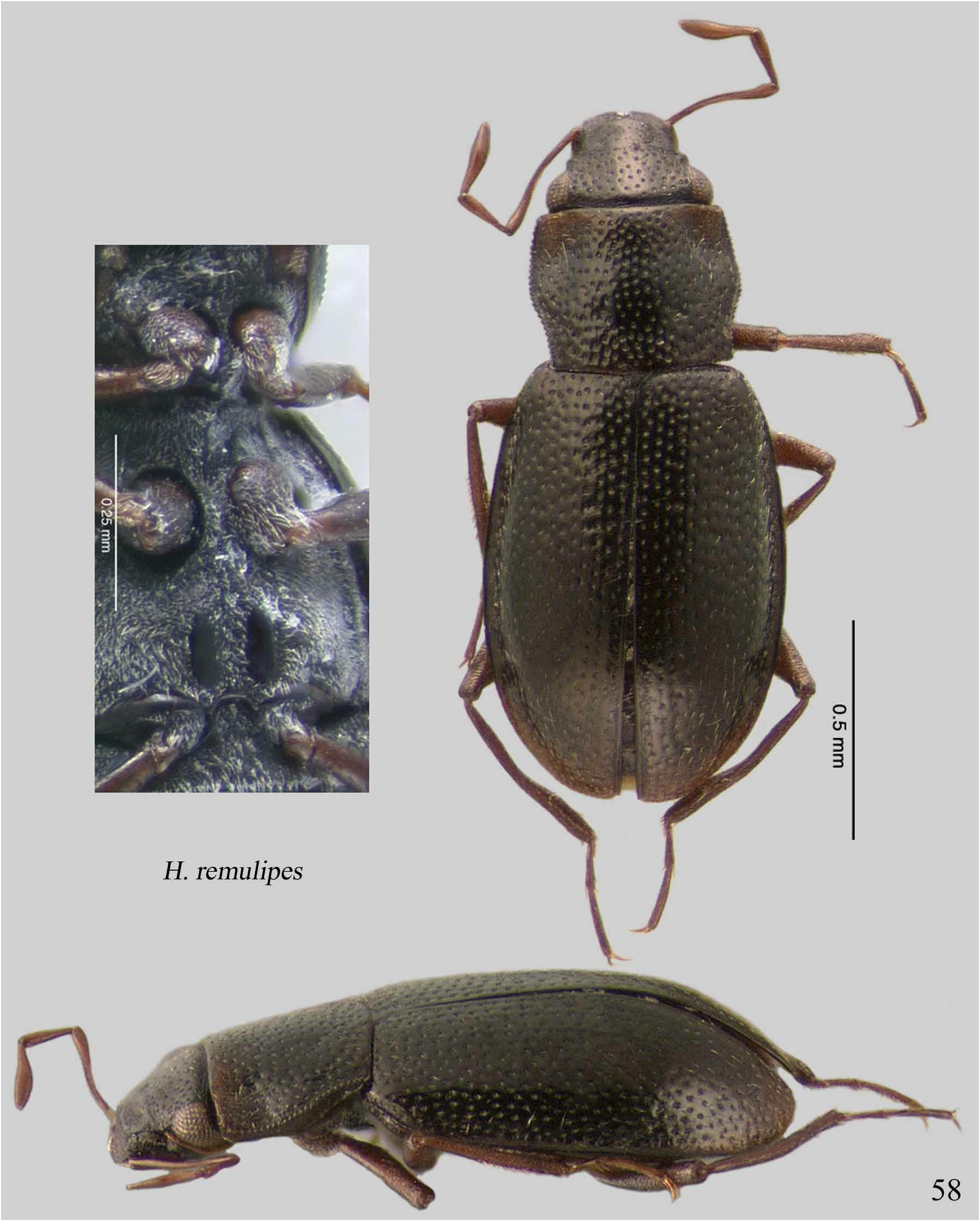
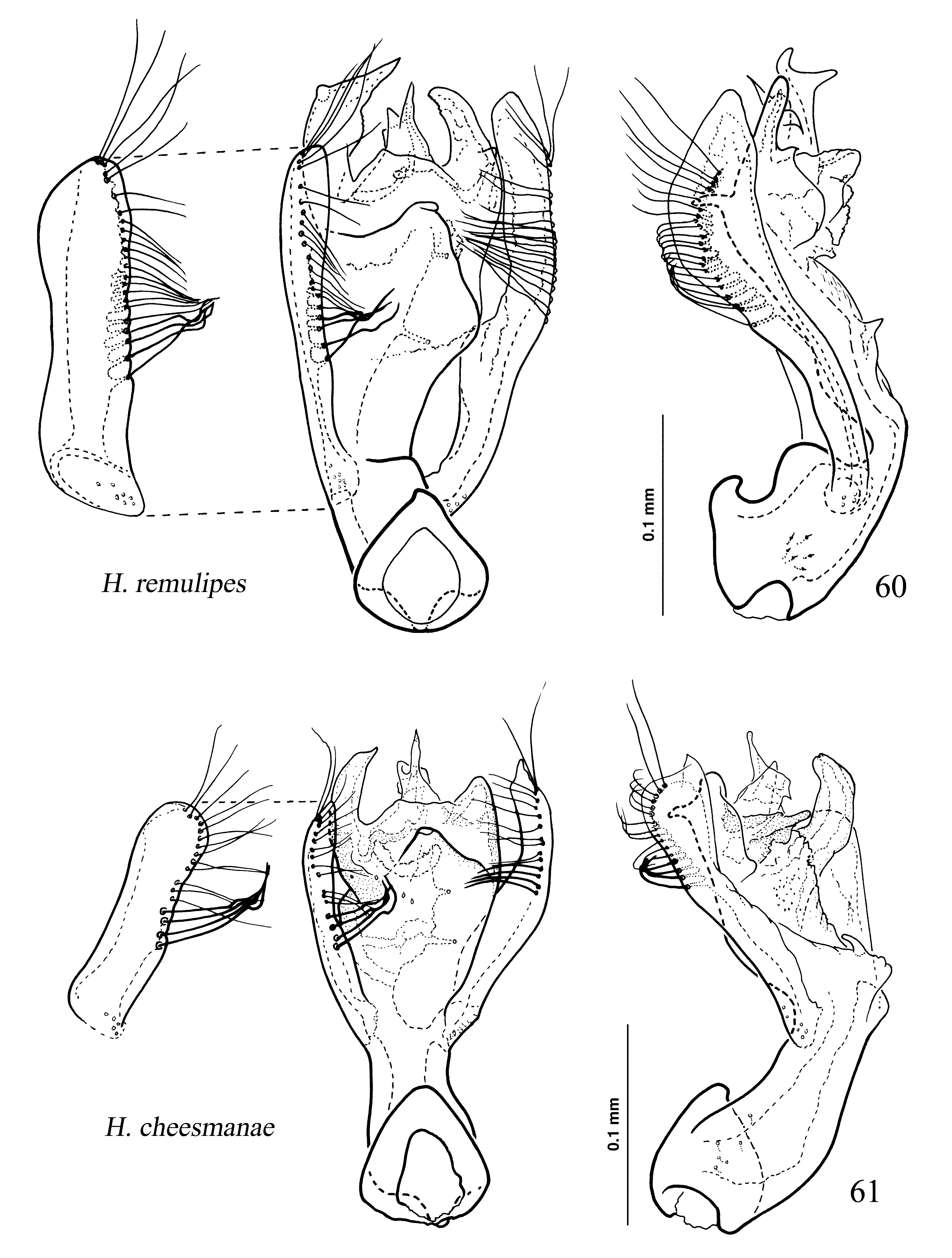
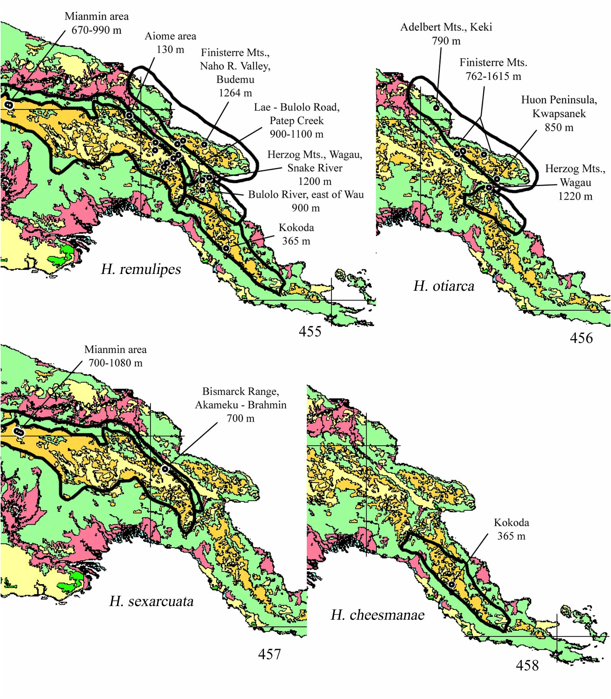
( Figs. 58 View FIGURE 58 , 60 View FIGURES 60–61 , 298–301 View FIGURES 298–303 , 369 View FIGURES 364–369 , 455 View FIGURES 455–458 )
Type Material. Holotype (male): Morobe Province: Herzog Mts., Vagau [Wagau], ex gravel banks of slow-running river, 1220 m, 6° 48' S, 146° 48' E, 11 i 1965, M. E. Bacchus (MEB 148b) ( NHM) GoogleMaps . Paratypes (162): Central Province: Kokoda , under stones, river side, 365 m, 8° 39' S, 147° 15' E, 1–30 viii 1933, L. E. Cheesman (577) (2 NHM) GoogleMaps ; Eastern Highlands Province: Akameku– Brahmin , Bismarck Range, 700 m, 5° 52.754' S, 145° 23.209' E, 24 xi 2006, Balke & Kinibel ( PNG 109) (2 ZSM) GoogleMaps ; Bottom of Kassem Pass , [GE est.] 1600–1700 m, 6° 18' S, 145° 52' E, 6 ix 1975, R. W. Hornabrook (5 NMNZ) GoogleMaps ; Kami River , Goroka , Eastern Highlands, [GE est.] 2000–2200 m, 6° 5' S, 145° 23' E, 23 vii 1965, R. W. Hornabrook (4 NMNZ) GoogleMaps ; Okapa , gravel banks of deep fast river, 1524 m, 6° 32' S, 145° 37' E, 10 ii 1965, M. E. Bacchus (MEB 189a) (1 NHM) GoogleMaps ; Purosa Valley , nr. Okapa, on submerged stones, [GE est.] 1500–1700 m, 6° 32' S, 145° 37' E, 8 ii 1965, M. E. Bacchus (MEB 182a) (62 NHM) GoogleMaps ; Umg. [=environs of] Igipinti, Korindaiop River, [GE est.] 600–1700 m, 6° 25' S, 145° 42' E, 18 vi 1979, W. G. Ullrich (1 MHNG) GoogleMaps ; Madang Province: Aiome area , 130 m, 5° 10.593' S, 144° 42.8' E, 11 iii 2007, Kinibel ( PNG 156) (4 ZSM) GoogleMaps ; Finisterre Mts. , Lower Naho Valley, Hinggia, ex rocks and gravel bank of swift clear stream, 762 m, 5° 50' S, 146° 7' E, 28 xi 1964, M. E. Bacchus (MEB 112) (14 NHM) GoogleMaps ; Finisterre Mts. , Naho River Valley, Budemu, ex gravel banks of large river, 1264 m, 5° 56' S, 146° 40' E, 18 x 1964, M. E. Bacchus (MEB 61) (7 NHM) GoogleMaps ; Finisterre Mts. , Naho River Valley, Damanti, ex gravel bank of shallow stream, 1082 m, 5° 55' S, 145° 58' E, 12 x 1964, M. E. Bacchus (MEB 49) (2 NHM) GoogleMaps ; Morobe Province: Bulolo River , east of Wau, 900 m, 7° 8' S, 146° 37' E, 15 x 1964, W. L. & J. G. Peters (1 CAS) GoogleMaps ; Herzog Mts. , Vagau [Wagau], ex leaves caught among rocks in shallow clear swift river, 1220 m, 6° 48' S, 146° 48' E, 9 i 1965, M. E. Bacchus (MEB 147a) (4 NHM) GoogleMaps ; Herzog Mts. , Vagau [Wagau], ex muddy gravel banks of shallow clear swift river, 1220 m, 6° 48' S, 146° 48' E, 9 i 1965, M. E. Bacchus (MEB 147b) (33 NHM) GoogleMaps ; Herzog Mts. , Vagau [Wagau], Snake River, ex muddy gravel bands of large slow river, 1220 m, 6° 48' S, 146° 48' E, 15 i 1965, M. E. Bacchus (MEB 152a) (2 NHM) GoogleMaps ; Herzog Mts. , Vagau [Wagau], Snake River, under gravel in bed of large slow river, 1220 m, 6° 48' S, 146° 48' E, 15 i 1965, M. E. Bacchus (MEB 152) (3 NHM) GoogleMaps ; Kassam Pass , Yung Creek, [GE est.] 1300–1500 m, 6° 12' S, 146° 0' E, 8 v 1979, W. G. Ullrich (1 MHNG) GoogleMaps ; Kassam Pass , Yung Creek, 14 vi 1979, W. G. Ullrich (9 MHNG) ; Lae–Bulolo road, Patep Creek, ex gravel bank of large fast river, [GE est.] 900–1100 m, 6° 52' S, 146° 37' E, 28 xii 1964, M. E. Bacchus (MEB 126) (2 NHM) GoogleMaps ; Sandaun Province: Mianmin , 670 m, 4° 53.329' S, 141° 35.263' E, 22 x 2008, S. Ibalim ( PNG 189) (1 ZSM) GoogleMaps ; Mianmin , pool, 990 m, 4° 54.57' S, 141° 35.49' E, 23 x 2008, S. Ibalim ( PNG 193) (1 ZSM) GoogleMaps ; Mianmin , river, 700 m, 4° 52.858' S, 141° 31.706' E, 21 x 2008, S. Ibalim ( PNG 197) (1 ZSM) GoogleMaps .
Differential Diagnosis. Differentiated from other members of the Otiarca group by the unicolored piceous pronotum and, in males, the uniquely modified metatibiae ( Figs. 58 View FIGURE 58 , 299 View FIGURES 298–303 ). The aedeagus shows some similarity in the shape of the base to that of H. otiarca , and some similarity in the distal piece shape to that of H. cheesmanae , while also having distinct unique form of parameres and distal piece ( Figs. 57 View FIGURES 56–57 , 60, 61 View FIGURES 60–61 ). The metaventrite, prosternum, and very complicated chaetotaxy of the tibiae are illustrated with SEMs ( Figs. 298–301 View FIGURES 298–303 , 369 View FIGURES 364–369 ).
Description. Size: holotype (length/width, mm): body (length to elytral apices) 1.57/0.68; head 0.23/0.37; pronotum 0.39/0.48, PA 0.42, PB 0.42; elytra 0.97/0.68. Dorsum piceous; legs and maxillary palpi dark brown.
Frons punctures ca. 1–2xef, slightly larger near eyes than medially; interstices shining, 1–3xpd. Clypeus microreticulate laterally, very finely sparsely punctate medially. Mentum and postmentum very sparsely very finely punctulate, shining. Genae raised, shining, without posterior ridge. Pronotum cordiform, median ca. 1/2 of anterior margin emarginate; punctures on disc ca. 1xpd those of frons, interstices shining, 2–3xpd, punctures larger and denser at anterior and posterior; PF1 absent; PF2 very shallow, obsolete; PF3 deep; PF4 absent.
Elytra with summit of posterior declivity slightly before midlength; lateral explanate margins moderately wide; on basal 1/3 punctures ca. 1xpd largest pronotal punctures, punctures becoming gradually smaller toward posterior. Intervals not raised, shining, on disc ca. 2–3xpd, as are interstices between punctures of a row, a few punctures subserial. Apices in dorsal aspect conjointly rounded, in posterior aspect margins forming shallow angle with one another.
Ratios of P2 width and plaque shape (P2/w/l/s) ca. 3/3/9/3. P1 laminate; median carina sinuate in profile. P2 raised, l/w ca. 2/1, sides slightly converging toward blunt apex. Plaques large, parallel, weakly transversely raised, at sides of deep median depression, each plaque tapering slightly from posterior to anterior. Metaventrite without midlongitudinal ridge. AIS width at straight posterior margin slightly greater than P2. All legs long and slender. Profemur (male) with small, sharply pointed tubercle next to trochanter; protibia slightly arcuate, widest subapically, cluster of small spines at this point, moderately long spine on medial surface at ca. distal 1/3. Mesotibia straight. Metatibia bent at midlength, distal 1/2 widened. Abdominal apex symmetrical; last tergite (male) notched. Aedeagus as illustrated ( Fig. 60 View FIGURES 60–61 ).
Etymology. "Little oar foot"; named in reference to the shape of the male metatibia, which is widened and bent such that it recalls the appearance of an oar as it is pulled through the water.
Distribution. Widely distributed, and with a wide elevation range; known from Areas 1–3, and 5–7; elevation range 130–2200 m ( Fig. 455 View FIGURES 455–458 ).


No known copyright restrictions apply. See Agosti, D., Egloff, W., 2009. Taxonomic information exchange and copyright: the Plazi approach. BMC Research Notes 2009, 2:53 for further explanation.
|
Kingdom |
|
|
Phylum |
|
|
Class |
|
|
Order |
|
|
Family |
|
|
Genus |