
Atractocarpus bracteatus Schltr. & K.Krause
|
publication ID |
https://doi.org/ 10.5252/a2012n1a12 |
|
DOI |
https://doi.org/10.5281/zenodo.5878998 |
|
persistent identifier |
https://treatment.plazi.org/id/03AD7622-FFB2-B644-28AE-93AA5F8FFBB8 |
|
treatment provided by |
Carolina |
|
scientific name |
Atractocarpus bracteatus Schltr. & K.Krause |
| status |
|
Atractocarpus bracteatus Schltr. & K.Krause View in CoL
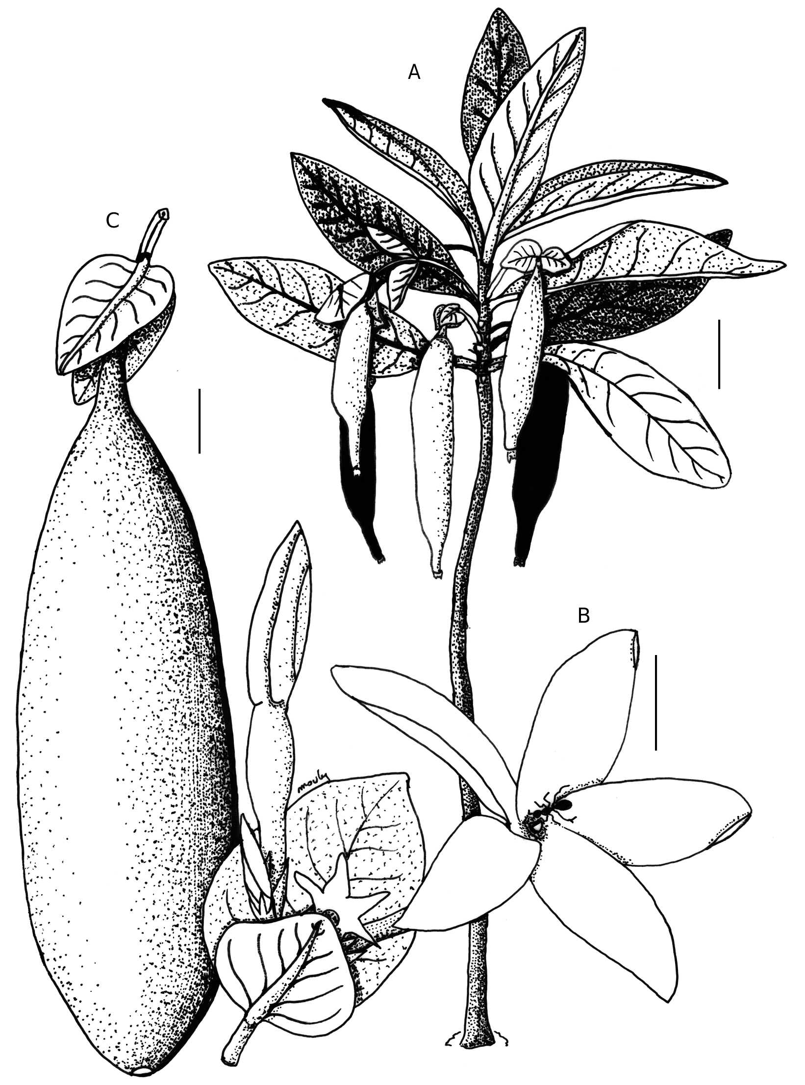
( Figs 1 View FIG ; 2 View FIG )
Botanische Jahrbücher für Systematik, Pflanzengeschichte und Plflanzengeographie 40 (92): 43 (1908).
— Type: New Caledonia. Couvelée , fl., 1900-1906, Le Rat 537 (neo-, P, hic designatus). — Previous type: New Caledonia. Süd-Bezirk, Couvelée , 1900-1906, Le Rat 90 (holo-, B †) .
Gardenia fusiformis Baill. ex Heckel View in CoL , Annales de l’Institut de Botanique-Géologique Colonial de Marseille, II, 10: 256 (1912).
—Type: New Caledonia, Baie de Prony , fr., 1862, Pancher s.n. (holo-, P).
OTHER SPECIMENS EXAMINATED. — New Caledonia. Baie de Prony , fl., 1910, d’Alleizette (leg. Godefroy) 354 ( P). — Forêts de la baie de Prony, fl. fr., IX.1868, Balansa 353 ( P). — Île Casy, dans la baie de Prony, fr., 24.VI.1869, Balansa 2014 ( P). — Collines éruptives situées vers le cours supérieur de la Tamoa, fl. fr., 11.IV.1870, Balansa 2896 ( P). — Vallée du Dothio, fl., XII.1871, Balansa 3419 ( P, P). — Environs de Mamarie, dans la partie supérieure du bassin du Tio, fl., I.1872, Balansa 3650 ( P). — Thio-Canala , Dothio, 21°35’S, 166°6’E, 170 m, fl. fr., 29.XII.1977, Bamps 6103 ( BR, NOU, P). GoogleMaps — Col d’Amieu, réserve forestière, 21°37’S, 165°49’E, 390 m, fl., 30.XII.1977, Bamps 6116 ( BR, P). GoogleMaps — Mt Mou, 300 m, 10.IX.1950, Baumann-Bodenheim 5859 ( P). — Île des Pins , E. Baie d’Oupi, 25.V.1951, Baumann-Bodenheim 13412 ( P). — Île des Pins , Kuto, 26.V.1951, Baumann-Bodenheim 13459 ( P). — Île des Pins , Kuto, fr., 27.V.1951, Baumann-Bodenheim 13591 ( P). — Île des Pins , île dans l’anse de Kanuméra, fr., 27.V.1951, Baumann-Bodenheim 13616 ( P). — Baie des Pirogues, plage, fr., 2.XII.1951, Baumann-Bodenheim 15818 ( P). — Creek Tao, fl., 26.XII.1951, Baumann-Bodenheim 15958 ( P). — Île des Pins (Kunié ), fr., 17.VII.1965, Bernardi 9698 ( G, P). — S. loc ., fr., I.1980, Bourret 2210 ( NOU). — Rivière des Pirogues, fr., 4.I.1978, Cabalion NC 352 ( P). — Bonne Anse, Baie du Sud, 1903, Cribb 1363 ( NOU, P). — Plum , creek Lucky, fr., 21.II.2001, Dagostini & Rigault 289 ( NOU). — Forêt Nord, fr., 7.IX.2006, Dagostini 1201 ( NOU, P). — Wenig verzweigtes Stammschen im Unterwuchs des Waldes im Malgrunde des Kalouéholatales , fr., II.1924, Däniker 3137 ( P, Z). — Mont Dore, fl., 26.III.1974, Debray 2202 ( P). — Île des Pins, fl., 24.I.1978, Debray 2707 ( P). — Île des Pins , bord de chemin, fl., 26.I.1978, Debray 2744 ( P). — Port Boisé, bord de rivière, fl., 1861, Deplanche 245 ( P). — S. loc ., fl., 1861, Deplanche 245 bis ( P). — Nouméa, littoral entre la Baie Nord et le Cap N’Dua, fl., II.1909, Franc 759 ( P). — Prony, lieux ombragés et frais, fl., I.1914, Franc 1639a ( P). — Prony , littoral, fl., I.1914, Franc 1766 ( P). — Port Boisé , littoral, fl., I.1914, Franc 1766a ( P). — Île des Pins , fl. fr., 1874-1876, Germain s.n. ( P). — Base du Mt Mou , 15.X.1950, Guillaumin & Baumann-Bodenheim 6889 ( P). — Base du Mt Dore , 8.II.1950, Guillaumin & Baumann-Bodenheim 7947 ( P). — Base du Mt Dore , 8.II.1951, Guillaumin & Baumann-Bodenheim 7956 ( P). — Vallée des Pirogues, fl., 29.III.1951, Guillaumin & Baumann-Bodenheim 11528 ( P). — Port Boisé , fr., 10.V.1979, Hoff 844 ( NOU). — Port Boisé , fr., 10.VI.1980, Hoff 2209 ( NOU). — Port Boisé , fr., 10.VI.1980, Hoff 2247 ( NOU). — Baie des Pirogues , 120 m, 16.XII.1950, Hürlimann 371 ( P). — Tonaouron-Goro, 10 m, fl., 9.I.1951, Hürlimann 567 ( P). — “ Sill ” serpentineux de St André Yallein, fl., 24.VII.1968, Jaffré 64 ( NOU). — Route de Prony , fr., 31.X.1972, Jaffré 998 ( NOU, P). — Route de Prony , fl., 4.I.1978, Jaffré 2164 ( NOU, P). — Route de Prony , baie N’go, sur éboulis péridotitiques et colluvions ferralitiques, lisière de forêt dense, fr., 27.VIII.2000, Jaffré 3445 ( P). — Prony , 300 m, fl., 1900-1910, Le Rat 1731 ( P). — Plum, just above beach, fr., 14.I.1956, MacKee 3778 ( P). — Île des Pins , Kuto, raised coral rock on sandy beach, 5-10 m, fr., 4.VIII.1956, MacKee 5021 ( P). — Mokoué, région de Canala, fl., 17.I.1961, MacKee 8156 ( P). — Crête à l’Ouest du Col de Petchicara, versant de Dothio, 500 m, fl., 7.V.1965, MacKee 12531 ( P). — Nakéty, 30 m, fl. fr., 8.V.1965, MacKee 12548 ( NOU, P). — Île des Pins , presqu’île d’Oro, forêt à l’intérieur de la presqu’île, 5 m, fr., 19.XII.1965, MacKee 14096 ( P). — Prony , Baie Nord, terrain serpentineux, 0-30 m, fr., 10.IV.1966, MacKee (leg. Corbasson) 14708 ( P). — Baie des Pirogues , maquis près de la plage, fl., 15.IV.1967, MacKee 16574 ( P). — Plum , Baie Ngo, maquis sur terrain rocheux serpentineux, 50 m, 28.I.1970, MacKee (leg. Corbasson) 21487 ( P). — Base S. E. du Mt Dore, fl., V.1970, MacKee 21874 ( NOU). — Kuebini , Île Nou, fl., 29.X.1970, MacKee 22785 ( NOU). — Île des Pins , plateau central, bandes de forêt en terrain rocheux serpentineux, 100 m, fl. fr., 1.IV.1971, MacKee 23571 ( P). — Nakety , Mokoué, forêt-galerie, 20 m, fl. fr., 13.XI.1971, MacKee 24686 ( P). — Port Boisé , littoral Est, forêt sur le terrain rocheux serpentineux, 0-10 m, fl., 13.VII.1973, MacKee 26940 ( P). — Port Boisé , littoral rocheux serpentineux, fr., 27.X.1973, MacKee (leg. Aymard) 27613 ( P). — Prony , Île Casy, terrain serpentineux, 0-40 m, fl. fr., 15.IV.1974, MacKee 28504 ( P). — Île des Pins , Baie des Crabes, fl. fr., 8.IX.1977, MacKee 33821 ( NOU, P). — Cap Reine Charlotte, forêt basse côtière, terrain rocheux serpentineux, 2 m, fl., 29.XI.1978, MacKee 36143 ( P). — Dothio , Haute Ouen Koura, fl., II.1979, MacKee 36583 ( NOU, P). — Doti, terrain serpentineux, 50 m, fr., 17.VIII.1984, MacKee (leg. Nasi) 42122 ( P). — Yaté, 15 m, fl. fr., 22.IV.1993, MacKee 46196 ( NOU, P). — Port Boisy , c. 20 air-km S of Yaté, coastal forest of Port Boisy, fr., 12.VI.1980, McPherson 2795 ( NOU, P). — Dothio River valley , near Thio, along road and trails by river, leaving highway just short of one-way portion, forest, c. 50 m, fr., 27.I.1983, McPherson 5431 ( MO, P). — Province Sud , Port Boisé, 20-50 m, fl. fr. 21.XI.2003, Mouly 149 ( P). — Province Sud , Île des Pins , sentier forestier entre la baie d’Oro et la baie d’Upi, 0-10 m, fl. 4.I.2004, Mouly & Innocente 269 ( P). — Col de Pétchécara, 100 m à gauche en suivant le début de la piste, forêt en face de la piste, fr., 14.IV.1999, Munzinger & Cabalion 479 ( P). — Forêt Anaïs , Prony, 22°18’06’’S, 166°42’56’’E, fr., 16.VI.2004, Munzinger 2130 ( NOU, P, UPS). GoogleMaps — Île des Pins , îlot Moro à l’Ouest de l’Île des Pins, 22°39’6’’S, 167°23’39’’E, fr., 27.VII.2004, Munzinger (leg. Cunkelman) 2278 ( P). GoogleMaps — Tontouta, 21°58’20’’S., 166°14’56’’E., fr., 26.II.2006, Munzinger 3348 ( NOU, P). GoogleMaps — Col de Mouirange, versant NO, fl. (fr. doubtful), 4.II.1966, Nothis 8 ( NOU, P). — Lisières des massifs dans le voisinage de la mer, 1862, Pancher s.n. ( P). — Baie de Prony , fr., Pancher s.n. ( P). — Passe entre Thio-Nakéty, c. 400 m, fl., 2.I.1912, Sarasin 371 ( P). — Creek Pernod, rive droite, 250 m, fl., 15.VI.1965, Schmid 330 ( NOU, P). — Kouakoué, bord de ruisseau, fr., 18.XI.1965, Schmid 772 ( NOU). — Île des Pins , vers la Baie de la Corbeille, fr., 10.VI.1967, Schmid 2138 ( NOU). — Île des Pins , forêt sur épandage au pied du Pic N’Ga, fl., 9.VI.1967, Schmid 2138 bis ( NOU). — Île des Pins , Est, fr., 3.V.1974, Schmid 4969 ( NOU). — Ilôt Casy , Baie de Prony, fr., 15.IV.1974, Sévenet 637 ( NOU). — Vers la Baie d’Oupi , Île des Pins, fr., 2.V.1974, Sévenet 652 ( NOU). — N.E. Baie Ngo, N. Pt. 16, fl., 7.III.1964, Stauffer 5768 ( NOU, P). — Petite forêt sèche, Mont-Dore, fr., 11.V.1978, Suprin 403 ( NOU). — Secteur de Ngo , Rivière des Pirogues, forêt de thalweg, fr., 17.VII.1980, Suprin 582 ( P). — Baie de Ngo, forêt sur éboulis et sol brun, c. 200 m, fr., 18.VIII.1978, Tirel 1202 ( P). — Bord du Dothio, route des Colons , fl. fr., 4.I.1965, Veillon 5 ( NOU, P). — Au-dessus de Baie N’Go, c. 200 m, fl., 4.II.1982, Veillon 4814 ( NOU, P). — Base du Pic du Pin, près de la mine Anna Madeleine, exploitation forestière Lafleur, clairière de la zone marginale forestière, terrain serpentineux, fl., 1.IV.1942, Virot 604 ( P). — Littoral près de Goro, au sud-est du village, c. 5 m, fl., 28.III.1942, Virot 644 ( P). — Presqu’île de Kuto , Île des Pins, bois littoraux humides, plateaux madréporiques émergés, c. 5 m, fr., 5.II.1943, Virot 985 ( P) .
DESCRIPTION
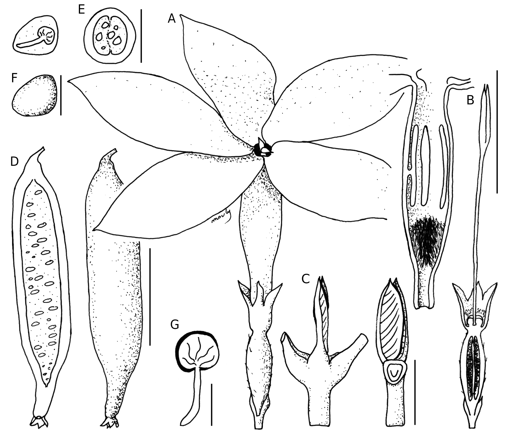
Dioecious, slender tree 1-3 m high, monocaul or few stemmed. Stipules paired, imbricate, lanceolate, 12-21 × 3-5 mm. Leaves of non-flowering shoots elliptic to oblanceolate, glabrous; petioles 16-22 mm long; lamina 160-320 × 50-160 mm, apex acuminate, base attenuated, glossy dark green, dull grey-green below, coriaceous; secondary veins 12-14 pairs at 50-60° to the midvein. Inflorescences axillary, branch-like to 250 mm long, perennial in male individuals, flowers arranged in cymes, up to 5-florous in male, and solitary to 3-florous in female individuals, flowers subtended by modified leaves, cordate, 30-40 mm long; flowers ± sessile, 5-merous, with a slightly sexual differentiation. Hypanthium 9-12 mm long and linear in male, ovules aborted; 12-16 × 3-5 × 3-5 mm, centrally inflated in female individuals. Calyx tube obconical, 3-4 mm long; lobes triangular, 1.5-2 mm long. Corolla tube 18 - 28 mm long, urceolate, c. 5 mm diameter at the widest point, glabrescent outside, glabrous inside except where it is bearded below the anthers. Corolla lobes lanceolate, c. 18 × 7-10 mm, glabrous. Anthers bilocular, 7-10 mm long, dorsifixed, supramedifixed, attached 4-5 mm from their apices, subsessile, inserted 5-6 mm below the sinuses of the corolla lobes. Style included, c. 25 mm long; stigmatic lobes 2, c. 9 mm long. Ovary bilocular, elongate, c. 9 × 2 × 2 mm, placentation axile, each bearing many ovules in a longitudinal row. Fruit berry, solitary, fusiform, 120-310 × 30-35 mm, smooth narrowing towards the calyx tube; exocarp smooth, green when mature; placentas extending in a whitish pulp. Seeds c. 5 × 5 × 0.6 mm; hilum occupying c. 0.6 of the perimeter of seed; exotesta cells with a thickened ring around the inner tangential wall and occasional interstitial thickenings. NOTE ON TYPIFICATION Herbaria where A. Le Rat collections are deposited (according to HUH Index of Botanists: http://kiki. huh.harvard.edu/databases/botanist_index.html) were consulted, as well as institutions where F. R. R. Schlechter usually sent herbarium material. The holotype Le Rat 90 has been destroyed in B (B herbarium communication), and any duplicate has been found nor in P where most of Le Rat collection is, neither in other herbaria (A, BM, BR, E, G, H, K, L, S, U, W, WRSL). The gathering Le Rat 537, collected in the type locality by the same botanist and deposited at P, is designated as a neotype.
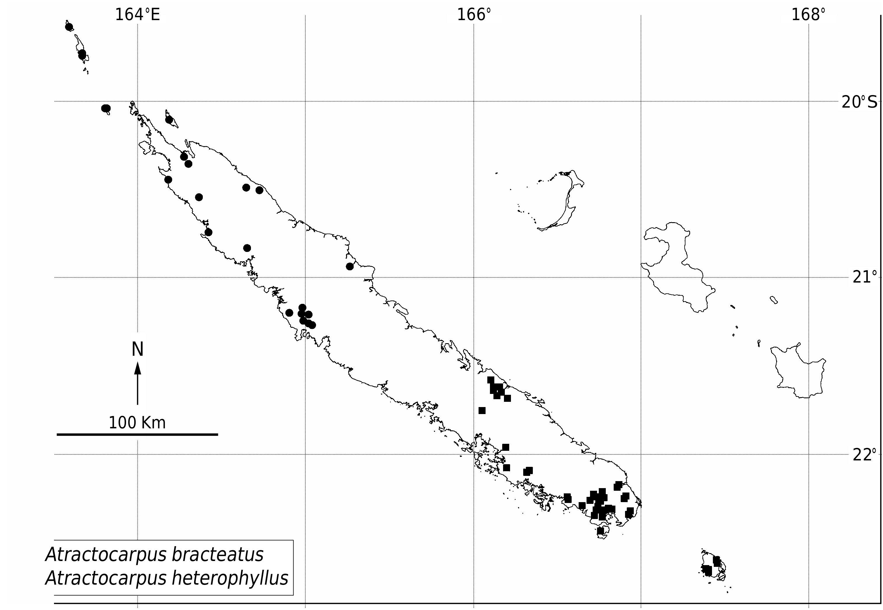
DISTRIBUTION, ECOLOGY, AND HABITAT Atractocarpus bracteatus is endemic to southeastern New Caledonia and the Isle of Pines ( Fig. 4 View FIG ). The species is a non obligatory riparian, and it grows mainly on ultramafic soils, calcareous rocks and occasionally on eroded elevated corals. The ant indicated in Figure 1 View FIG , as observed in the field, is not an evidence of ant-pollination, but an indication that A. bracteatus nectar secretions attract ants, forming temporary colonies on plant individuals. Fruiting takes long time in the species, as observed on cultivated specimens in New Caledonia, necessitating more than two years to reach maturity.
NOTE
Two unpublished names, Genipa semperflorens and Genipa xylopioides , are present in annotations by Baillon on herbarium sheets in P. Genipa was at that time one of the few considered genera in Gardenieae , together with Gardenia and Randia . Both Randia and Genipa are now restricted to the Neotropics ( Persson 2002; Gustafsson & Persson 2002), and New Caledonian Gardenieae species were never considered as potential Genipa species since then.
| P |
Museum National d' Histoire Naturelle, Paris (MNHN) - Vascular Plants |
| B |
Botanischer Garten und Botanisches Museum Berlin-Dahlem, Zentraleinrichtung der Freien Universitaet |
| BR |
Embrapa Agrobiology Diazothrophic Microbial Culture Collection |
| NOU |
Institut de Recherche pour le Développement |
| E |
Royal Botanic Garden Edinburgh |
| G |
Conservatoire et Jardin botaniques de la Ville de Genève |
| Z |
Universität Zürich |
| S |
Department of Botany, Swedish Museum of Natural History |
| MO |
Missouri Botanical Garden |
| UPS |
Uppsala University, Museum of Evolution, Botany Section (Fytoteket) |
| NO |
Tulane University Herbarium |
No known copyright restrictions apply. See Agosti, D., Egloff, W., 2009. Taxonomic information exchange and copyright: the Plazi approach. BMC Research Notes 2009, 2:53 for further explanation.
|
Kingdom |
|
|
Phylum |
|
|
Class |
|
|
Order |
|
|
Family |
|
|
Genus |
Atractocarpus bracteatus Schltr. & K.Krause
| Mouly, Arnaud 2012 |
Gardenia fusiformis Baill. ex Heckel
| Baill. ex Heckel 1912: 256 |