
Bromus carinatus Hooker & Walker Arnott (1840: 403)
|
publication ID |
https://doi.org/10.11646/phytotaxa.185.1.1 |
|
DOI |
https://doi.org/10.5281/zenodo.18320921 |
|
persistent identifier |
https://treatment.plazi.org/id/0389862D-DE44-005E-E3DB-FB1FE3D61AE9 |
|
treatment provided by |
Felipe |
|
scientific name |
Bromus carinatus Hooker & Walker Arnott (1840: 403) |
| status |
|
5. Bromus carinatus Hooker & Walker Arnott (1840: 403) View in CoL .
Ceratochloa carinata (Hook. & Arn.) Tutin in Clapham et al. (1952: 1458). Type:— UNITED STATES OF AMERICA. California: Monterrey or San Francisco, at no great distance from the coast, 1833, D. Douglas s.n. ( lectotype BM-000555843!, designated by Pavlick 1995: 40, isolectotypes E-00064818!, US-865522A fragm. ex BM, MO-2957183!, NY-346213!).
Festuca pendulina Sprengel (1825: 356) View in CoL , replacement name. Replaced name: Bromus pendulinus Sessé ex Lagasca (1816: 4) View in CoL , nom. illeg. Blocking name: Bromus pendulinus Schrader (1810: 70) View in CoL . Bromus hookeri var. pendulinus (Spreng.) Fournier (1886: 128) View in CoL . Type:—Habitat in Nueva Hispania [ México] unde semina advexit D. Sessé ann. 1804 [grown from seeds collected by Sessé in "Nova Hispania"] ( holotype MA-14058, isotypes M, US-865450! fragm. ex M).
Bromus luzonensis Presl (1830: 262) View in CoL . Triticum luzonense (Presl) Kunth (1833: 446) View in CoL . Type:— California or British Columbia: Haenke s.n. ( holotype PR!). See Veldkamp (1990: 660) for typification and discussion of label errors. Also see comments below.
Bromus hookerianus Thurber (1874: 493) View in CoL , replacement name. Replaced name: Ceratochloa grandiflora Hooker (1840: 253) . Blocking name: Bromus grandiflorus Weigel (1772: 9) View in CoL , nom. illeg. superfl. Bromus carinatus var. hookerianus (Thurb.) Shear (1900: 60) View in CoL . Type:— UNITED STATES OF AMERICA. Oregon: plains of the Columbia River, 1826, D. Douglas s.n. ( lectotype K, designated by Shear 1900: 61, isolectotype US-865712! fragm. ex K).
Bromus oregonus Nuttall ex Hooker (1856: 18) View in CoL , nom. nud. Bromus oregonus Nuttall ex Shear (1900: 59) View in CoL , nom. inval., as syn. of Bromus carinatus View in CoL . Type:— UNITED STATES OF AMERICA. Upper Missouri and Oregon territories, Geyer 244.
Bromus virens Buckley (1862: 98) View in CoL . Type :— UNITED STATES OF AMERICA. Rocky Mountains and Columbia River, Nuttall s.n. ( holotype PH-00008640!, isotypes BM-000578894!, US-865484 fragm.).
Bromus hookeri var. schaffneri Fournier (1886: 127) View in CoL . Bromus schaffneri (E. Fourn.) Scribner & Merrill (1901: 30) View in CoL . Type:— MÉXICO: secus margines agrorum ubi Mays consit a, J.G. Schaffner 42 ( holotype P-00647229!, isotype US-865501! fragm. exP).
Bromus hookeri var. schlechtendalii Fournier (1886: 127) View in CoL . Bromus proximus var. schlechtendalii (E. Fourn.) Shear (1901: 245) View in CoL . MÉXICO. San Luis de Potosí , August 1891, Virletii 1420 ( lectotype P-02632337 !, designated here, isolectotype P-02632340 !). The lectotype is chosen from among the five syntypes listed by Fournier (1886) .
Bromus virens var. minor Scribner ex Beal (1896: 614) View in CoL . Type :— UNITED STATES OF AMERICA. Oregon, 30 May 1884, T. Howell s.n. ( holotype US-1007683 !) .
Bromus carinatus var. californicus Shear (1900: 60) View in CoL . Type:— UNITED STATES OF AMERICA. California: San Diego, 24 May 1884, C.R. Orcutt 511a ( lectotype US-1007777 !, designated here). An annotation by P.M. Peterson in 2002 on the specimen indicates the lectotype is designated in "Contr. U.S. Natl. Herb. 2003 in ed.," but the lectotypification does not appear there.
Bromus carinatus var. densus Shear (1900: 61) View in CoL . Type:— UNITED STATES OF AMERICA. California: Channel Islands, San Nicholas Island, about Opuntia , April 1897, B. Trask 12 (isotype US-340331 !) .
Bromus carinatus var. linearis Shear (1900: 61) View in CoL . Type:— UNITED STATES OF AMERICA. California. 1875, Vasey ( holotype US-81566 !).
Bromus laciniatus Beal (1896: 615) View in CoL . Ceratochloa laciniata (Beal) Holub (1973: 170) . Type:— MÉXICO. Oaxaca: Sierra de San Felipe, alt. 9500 ft, 17.1°N, 96.85°W, 1894, C.G. Pringle 4897 ( holotype MSC-4813!, isotypes E-00373824, GH, JE-00006481, K, MEXU-5884!, MO-2957787, NY, US-250847!).
Bromus subvelutinus Shear (1900: 52) View in CoL . Type:— UNITED STATES OF AMERICA. Nevada: Reno , 1887, S.M. Tracy 249 ( holotype US-81594 !) .
Plants short-lived perennials, not rhizomatous. Culms up to 150 cm tall, 2–6 cm wide at base, erect, glabrous or pubescent below inflorescences; nodes 3–6, glabrous or pubescent. Leaf sheaths glabrous or pubescent to pilose, hairs up to 2 mm long, throats glabrous or pubescent; auricles absent; ligules (1–)2–3(–4) mm long, glabrous or pubescent, lacerate-erose; blades up to 33 cm × (2–)3–6(–11) mm, flat, abaxial and adaxial surfaces glabrous or pubescent, midveins narrowing beneath the collar, margins serrulate. Panicles 5–30 cm long, open, branches erect, ascending or spreading, 4–22 cm long including spikelets, pedicels longer or shorter than spikelets, glabrous, scabrous, or pubescent, 1–3(–9) spikelets per branch. Spikelets 2–4 cm long, 4–11-flowered, elliptic to lanceolate, strongly laterally compressed; glumes glabrous or pubescent, green to purple along and between the nerves, margins hyaline, midnerves glabrous to scabrous distally; lower glumes 6.5–12 mm long, lanceolate, 3–7-nerved, apices acute; upper glumes 9–15 mm long, shorter than the lowest lemma, obovate-lanceolate, 5–9-nerved, apices acute to acuminate; lemmas 11–20 mm long, lanceolate, laterally compressed, strongly keeled distally, apices acute to obtuse, 7–9-nerved, nerves usually not raised, glabrous, scabrous, or pubescent, hairs sometimes restricted to margins, hairs up to 0.5 mm long; awns 2–15 mm long, inserted 0–0.5 mm below the lemma apex, straight; paleas shorter than the lemmas, backs glabrous or pubescent, keels ciliate, cilia up to 0.2 mm long; anthers 0.5–4.5 mm long; caryopses 9−11 mm long. 2 n = 56 ( Pohl & Davidse 1971).
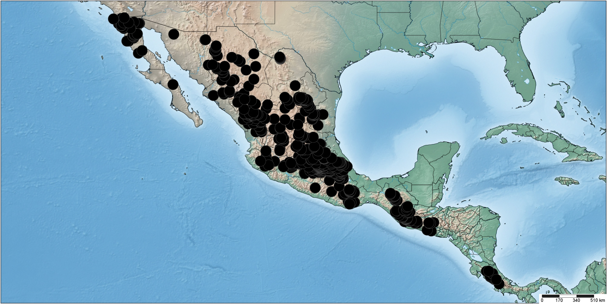
Distribution: ―Native. Bromus carinatus s.l. is widespread in México ( Fig. 14 View FIGURE 14 ).
Ecology:— Meadows, pastures, barrancas and slopes; associated with Pinus arizonica , P. jeffreyi Balf. in Murray (1853: pl. s.n.), Abies religiosa (Kunth in Humboldt et al. 1817: 5) Schlechtendal (1830: 77), Pseudotsuga menziezii ( Mirbel 1825: 63) Franco (1950: 74) , Juniperus deppeana , Cupressus arizonica , Quercus spp. , Q. rugosa Née (1801: 275) , Arbutus xalapensis , Fallugia paradoxa ( Don 1825: 576) Endl. ex Torr. in Emory (1848: 139), Arctostaphylos pungens , Salvia Linnaeus (1753: 23) , Baccharis Linnaeus (1753: 860) and Ceanothus . Elevation 1500−3200 m.
Common Names: ― California brome (English); basicuaáre, bromo de California, masiyague, pipillo (Spanish).
Comments: ― Bromus carinatus is used as fodder in México ( Saulés & Dávila Aranda 1992). Bromus carinatus seeds are used to make tejino or tesgüino, and when there is shortage of food they are apparently used as corn ( Saulés & Dávila Aranda 1992). Tejino is "… a thick, milky, nutritious brew made from corn fermented with a local grass seed ( basiáhuari)" ( Kennedy 1963).
Variation in the Bromus carinatus complex in North America— Bromus sect. Ceratochloa comprises the hexaploid (6x) B. catharticus complex native to South America, the octoploid (8x) B. carinatus complex native to North America, the North American duodecaploid (10x) B. arizonicus ( Stebbins 1981) , and recently discovered duodecaploid taxa from South America similar in morphology to B. ayacuchensis Saarela & P.M. Peterson in Saarela et al. (2006: 919), for which the chromosome number is unknown ( Williams et al. 2011). There is extensive morphological variation within each of the hexaploid and octoploid complexes, which has led to multiple, often-conflicting taxonomic treatments for each. Recent genetical and morphological study of the B. catharticus complex supported recognition of two polymorphic species ( Massa et al. 2001, 2004). Similar revisionary work is necessary to better characterize morphological and molecular variation in the B. carinatus complex throughout its natural range.
The B. carinatus complex ranges throughout much of western North America, from Alaska to Central America. It has been introduced elsewhere, including Europe ( Verloove 2012), China ( Liu et al. 2006) and New Zealand ( Stewart 1996). It comprises primarily cleistogamous plants and is extremely variable. Multiple taxa have been described in it on the basis of such characters as duration (i.e., annual, perennial, biennial), pubescence of the leaves and spikelets, blade width, panicle size and awn length ( Hitchcock et al. 1969). In the early part of the twentieth century, multiple narrowly circumscribed taxa were generally recognized in western North America north of México ( Piper 1906, Jepson 1912, Millspaugh & Nuttall 1923, Tidestrom 1925, Hitchcock 1951), whereas in more recent decades most authors have tended to recognize fewer taxa, often including much of the variation in a single species, B. carinatus , usually with infraspecific taxa ( Hitchcock et al. 1969, Stebbins 1981, Jones et al. 1997, Pavlick & Anderton 2007). Pavlick (1995), however, recognized six taxa in North America north of México, distinguished primarily by differences in the vestiture of leaf sheaths and blades and panicle size: B. sitchensis Trin. in Bongard (1832: 173), B. aleutensis Trin. ex Griseb. in Ledebour (1852: 361), B. maritimus ( Piper 1905: 148) Hitchc. in Jepson (1912: 177), B. carinatus (including vars. carinatus and marginatus ), B. polyanthus Scribner ex Shear (1900: 56) and B. subvelutinus Shear (1900: 52) . Pavlick & Anderton (2007) recognized the same taxa in the Flora of North America, except B. subvelutinus was included in B. carinatus var. carinatus .
Numerous authors have commented on the extensive morphological variation in the complex, and have noted that there is considerable intergradation among taxa throughout the range of the complex ( Shear 1900, Hitchcock 1951, Hitchcock et al. 1969, Pavlick 1995). Given the variation and difficulties in delimiting taxa in the B. carinatus complex, Stebbins (1981) suggested that all taxa be treated as a single species. No treatment so far has taken this approach. An AFLP study of B. carinatus s.l., based on 30 accessions collected throughout western North America, identified four major genetic lineages and five unique accessions, but the authors did not comment on morphological variation within the major lineages, or whether or not the lineages correspond to previouslyrecognized taxa in the complex ( Massa & Larson 2005). Barkworth et al. (2006) studied morphological and geographical variation in B. carinatus s.s., B. marginatus and B. polyanthus . Their results supported recognition of B. carinatus with two varieties, and B. polyanthus . Barkworth et al. (2006) considered Massa & Larson's (2005) molecular results for the complex and noted that, upon examination of the voucher specimens used in the AFLP study, the three accessions in Massa & Larson's (2005) "group 4" are B. polyanthus , while the others are B. marginatus (= B. carinatus var. marginatus ).
Several taxa in the complex were described from México in the 19 th century, including B. pendulinus , B. hookeri var. schaffneri , B. hookeri var. schlechtendalii and B. laciniatus . Shear (1900) recognized B. laciniatus in México, whereas Hitchcock (1913) recognized two species: B. carinatus , from Baja California, and B. pendulinus (syn. B. laciniatus ), distributed throughout México. Hitchcock later recognized the taxon in Central America and México as B. laciniatus , realizing that the name he used earlier, B. pendulinus Sessé , is a later homonym of B. pendulinus Schrad. ( Hitchcock 1930, 1935, 1951). Other authors also recognized Central American plants as B. laciniatus ( Standley 1937, Swallen & McClure 1955). It is not clear in any of these treatments how to distinguish B. laciniatus from plants of the B. carinatus complex from north of Mexico. Johnston (1943) treated plants in the group from Coahuila as B. schaffneri and Bromus sp. (two unnamed taxa). Soderstrom & Beaman (1968) considered B. laciniatus to be a synonym of B. carinatus , a treatment followed by subsequent workers ( Beetle 1977, Pohl 1980, Gould & Moran 1981, McVaugh 1983, Pohl & Davidse 1994, Espejo-Serna et al. 2000, Morales 2003, Pavlick et al. 2003). Soderstrom & Beaman (1968) included B. arizonicus in their concept of B. carinatus , a view with which we do not agree (also see Stebbins 1981). We recognize all plants in México and Central America as B. carinatus , maintaining current usage of the name ( Pavlick & Anderton 2007, Saarela & Peterson 2012). Within B. carinatus we recognize two varieties, distinguished by awn length, as in Barkworth et al. (2006) and Pavlick & Anderton (2007). Not all of the specimens examined for this study were determined to variety; those determined only to species are listed below as B. carinatus s.l.
Although B. carinatus is the most widely-used name in the complex, the little-used name B. luzonensis Presl (1830: 262) has priority for plants currently treated under this name. Bromus luzonensis was described from a collection made by Haenke that was reported to have come from Luzon, Philippines. Veldkamp (1990) pointed out that there are no Bromus species in the Malesian lowlands, and that the specimen matches B. breviaristatus (= B. carinatus var. marginatus ) from western North America. He suggested there was a labelling error on the specimen, as Merrill (1922) noted earlier, and that the specimen came from either British Columbia or California, where Haenke collected ( Sterling 1997). Bromus luzonensis has not been included in most treatments of Bromus in the United States (see Table 1 View TABLE 1 in Barkworth et al. 2006), probably because it was thought to represent a non-American species. Pavlick (1995) recognized B. luzonensis as a synonym of his resurrected B. subvelutinus (even though B. luzonensis is an earlier name), a species that most later authors, including Pavlick & Anderton (2007), have included in B. carinatus . If B. luzonensis and B. carinatus s.l. are considered to be the same species, the correct name for the species is B. luzonensis .
Given the current circumscription of taxa in the complex, there are two options for resolving this nomenclatural problem: the species could be recognized as B. luzonensis , which would require new combinations for all infraspecific taxa in the group, or conservation of the widely-used and familiar name B. carinatus against B. luzonensis could be argued for. We feel it is premature to argue for conservation pending a more detailed study of variation and species boundaries in the entire B. carinatus complex, and particularly resolution of the status of B. sitchensis . If addititional data support recognition of a single species in the B. carinatus complex, the correct name for the species would be B. sitchensis —the oldest name in the complex. Boivin (1967) took this approach in his list of Canadian plants, at least in part, as he treated B. marginatus as variety of B. sitchensis . If B. sitchensis ( type from Sitka, Alaska, representing a form with large, open panicles with long branches) is supported as a distinct species, as recognized in current treatments, the next oldest available name is B. luzonensis .
Morphological variation in Bromus carinatus in México and Central America — Panicle size in B. carinatus varies dramatically throughout the region, ranging from narrow with very short and almost non-existent ascendingappressed branches, to large and open with branches up to 21 cm long. Most plants from Baja California have narrow panicles with short ascending-appressed branches, densely pubescent sheaths and blades and pubescent spikelets. Such plants correspond to the taxon described by Shear as B. subvelutinus , which was recognized by numerous earlier authors (sometimes as B. breviaristatus ) and more recently by Pavlick (1995), but included in B. carinatus in more recent treatments (see Table 1 View TABLE 1 in Barkworth et al. 2006). Many plants from the Sierra Madre Occidental and Sierra Madre Oriental have glabrous sheaths and blades and lemmas that are glabrous across the back and short-pubescent along the margins, but there is considerable variation in each of these characters, which vary independently among collections. The following examples have the character states as listed above, unless otherwise mentioned: Sharp 44418 (GH) from Puebla and Molina R. & Montalvo 21822 (GH) from El Salvador have pubescent or short-pilose sheaths; several specimens have lemmas that are more or less evenly pubescent across the back ( Marsh 1439, GH, from Coahuila; Rose & Painter 6750, GH, from Hidalgo; Kenoyer 2047, GH, from Guanajuato); Palmer 346 (GH) from Durango has pubescent lemmas and sheaths and blades pubescent along the margins; Palmer 171 (GH) from Durango has essentially glabrous lemmas and pilose sheaths; and Harvey 6380 (GH, MICH) from Sinaloa has glabrous lemmas.
Plants from the Sierra Madre Occidental and Sierra Madre Oriental generally have panicles with the longest lower branches including the spikelets ranging in length from (5–) 8–12 cm, but there are numerous collections from throughout the region with slightly to much longer branches, ranging from 12.5–21 cm long. Examples include: Pringle 13243 (GH) from México (branches 12.5 cm long), Harvey 8538 (MICH) from México ( 16 cm), Botteri 727 (GH) from México ( 19 cm), Nicolás & Arséne 270 (GH) from Puebla ( 21 cm), and Williams et al. 26394 (F) from Guatemala. LeSueur Mex-110 (GH) from Chihuahua has lower panicle branches up to 14.5 cm long, glabrous glumes and glabrous sheath collars. The latter two characters fit B. polyanthus , a taxon known from the adjacent U.S.A., but the panicle branches in this species are reported to be < 10 cm long ( Pavlick & Anderton 2007); we keep this specimen in B. carinatus . In Pavlick & Anderton (2007), plants with lower branches greater than 10 cm would key to B. sitchensis , a taxon distributed primarily along the coast from the Aleutian Island through British Columbia and to southern California, and characterized by its large, open panicles with lower panicle branches 10–20 cm long. Verloove (2012) has recently reviewed in detail the differences between B. carinatus and B. sitchensis reported in the literature. The boundaries between B. carinatus and B. sitchensis are unclear and are seemingly arbitrary given the variation in panicle size throughout the range of the B. carinatus complex (J.M. Saarela, personal observation). Plants with very large panicles are scattered throughout México and Central America, and we include these in B. carinatus .
Specimens Examined ( Bromus carinatus s.l.):― COSTA RICA. Alajuela: in and around Zarcero, Cantón Alfaro Ruíz, Hwy. 15, [ 10.1833°N, 84.4°W], 1700–2000m, 3 September 1966, A.S. Weston 2154, D.F. Weston & J. Weston (CR-82588) GoogleMaps . Cartago: km post 19 along road to the crater of Volcán Irazú, [ 9.97°N, 83.85°W], 2600m, 1 August 1968, R.W. Pohl 10807 & G. Davidse (CR-47121); carretera al Volcán Irazú, cerca del Santorio Durán, [ 9.97°N, 83.85°W], 2340 m, 2 November 1968, J.J. Códoba 1013 (CR-74092); Oreamuno, P.N. Volcán Irazú, Cuenca del Sarapiquí , 9.9858°N, 83.8425°W, 3200–3300 m, 2 May 2003, E. Alfaro 4304 & K. Quirós (CR-0252396, INB, MO); Volcán Irazú, within 1 km radius of Sanitoria Durán, [ 9.97°N, 83.85°W], 2300–2450m, 21 November 1966, A.S. Weston 3385, D.F. Weston & J. Weston (CR-81823); along road to crater of Volcán Irazú, [ 9.97°N, 83.85°W], 2600 m, 7 August 1966, R.W. Pohl 10235 & C. Calderon (CR-141103, MO); Cartago, Paraíso, Orosi, 9.5571°N, 83.708°W, 14 February 2008, S. Lobo 1970, J. Guerra A. & K. Romoleroux s.n. ( CR) GoogleMaps . Puntarenas: Térraba , 23 January 1943, J. León 1118 ( CR) . San José: Dota, Copey, 9.5778°N, 83.8019°W, 2343 m, 22 February 2001, A. Estrada 2785, J. Sánchez, J. Solano et al. (CR-22749); Dota, Cerca de Providencia GoogleMaps , 9.59°N, 83.8835°W, 2785 m, 3 July 2000, S GoogleMaps . Simis 309 ( INB); León Cortés , Cuenca del Pirrís-Damas, 9.55°N, 83.7875°W, 2100 m, 15 November 1998, J.F GoogleMaps . Morales 6716 ( INB, MO) & 6717 (CR-0243248); Pérez Zeledón, Cuenca Térraba-Sierpe , Cerro de la Muerte, 9.4636°N, 83.7025°W, 1650m, 23 September 2005, D. Santamaría A GoogleMaps . 3153, A. Antonelli & C . Persson ( INB, MO). GUATEMALA. Quezaltenango: Chiquilaja , 2340 m, [ 14.8°N, 91.67°W], 24 June 1954, M GoogleMaps . de Koninck 71 ( US-2151637 ). Solola: Volcán Atitlan , near summit, ca. 3535 m, [ 14.58°N, 91.19°W], 10 August 1960, J.H GoogleMaps . Beaman 4060 (F-2208205, MSC-171813 ). MÉXICO. Aguascalientes: Mesa Potrero Viejo, Calvillo , [ 21.85°N, 102.72°W], September 1988, E GoogleMaps . Lugo 277 ( MEXU-1110801 ); Mpio. Aguascalientes, Aguascalientes, [ 21.89°N, 102.29°W], 8 August 1978, E GoogleMaps . de la Cerda s.n. ( MEXU-272092 ); Mpio. Aguascalientes, La Cantera , [ 21.83°N, 102.37°W], 29 November 1978, G GoogleMaps . Calvillo Michaus s.n. ( MEXU-304337 ); Mpio. Aguascalientes, Pabellón , [ 21.6167°N, 102.28°W], 17 December 1978, J GoogleMaps . Romo D. s.n. ( MEXU-272147 ); Mpio. Aguascalientes, Panteón La Cruz , 21.8867°N, 102.3083°W, 1979, F GoogleMaps . Flores A . s.n. ( MEXU-300735 ); Mpio. San José de Gracía, Laguna Seca , [ 22.15°N, 102.42°W], 2650 m, September 1991, O GoogleMaps . Sánchez Herrera 79 ( MEXU). Baja California: carretera vieja Tijuana-Ensenada a la altura de Santa Rosa , [ 32.1°N, 116.86°W], 28 April 1981, R GoogleMaps . Guzmám 1233 ( MEXU-1069520 ); Ensenada , [ 31.87°N, 116.59°W], 27 May 1993, Jaramillo V GoogleMaps ., Villegas G . & Domínguez O . 82 ( MEXU-1098001 ); San Martín Island , trail up to top, 30.5°N, 116.1167°W, 10 January 1983, T GoogleMaps . Oberbauer 135 ( SD-127651 ). Chihuahua: Mpio. Guachochic, Cusárare , near old church, 27.6167°N, 107.5333°W, 6900 ft, 4 August 1974, R.A GoogleMaps . Bye 6771 ( MEXU-821133 ); Mpio. Bocoyna, Ejido San Ignacio Arareco , km 85 carretera Balleza-Guachochic , [ 26.91°N, 106.94°W], 24 September 1981, M.E GoogleMaps . Siqueiros 1607 ( MEXU-1098006 ); Mpio. Madera, 1.5 km de Colonia Chuhuichupa , [ 29.62°N, 108.4°W], 2240 m, 13 October 1990, O GoogleMaps . Bravo Bolaños 1894 ( MEXU-583327 ); Mpio. Madera, Ejido Madera , [ 29.19°N, 108.13°W], 2400 m, 8 September 1977, Blanco 06/77 ( MEXU-1035076 ); near the airstrip SE of Creel, [ 27.81°N, 107.63°W], 7300 ft, 5 August 1972, R.A GoogleMaps . Bye Jr. 2689 ( MEXU). Coahuila: Arteaga , 25.44°N, 100.85°W, 1660 m, 20 July 1993, P GoogleMaps . Moya 432 ( MEXU-1099496 ); Mpio. Ramos Arizpe, Predio La Esmeralda , 25.5353°N, 100.96°W, 1390 m, 16 June 1994, E GoogleMaps . Pérez 51 ( MEXU-1099439 ); Sierra Zapalinamé, Cerro El Penitente , en exposición noroeste de la sierra, 25.3483°N, 100.9047°W, 2990 m, 15 September 2005, J.A GoogleMaps . Encina, F.J . Encina & J.M . Guillermo E . 1476 ( ANSM). Distrito Federal: a las faldas del Cerro Teuhtli, Delegación Milpa Alta , [ 19.19°N, 99.02°W], 2470 m, 24 October 1985, E GoogleMaps . Manrique et al. 1224 ( MEXU-1110815 ); Ajusco, Rancho Viejo Cuilotepec Tlalpan , [ 19.2075°N, 99.2581°W], 2730 m, 19 September 1985, E GoogleMaps . Manrique et al. 1145 ( MEXU-1110822 ); camino al Volcán Guadalupe, Delegación Tláhuac , [ 19.27°N, 99.02°W], 10 October 1985, A GoogleMaps . Miranda & P . Guerrero 46 ( MEXU-1110784 ); Cerro del Ajusco, "Tierra y Libertad" Delegación Tlalpan , 19.2069°N, 99.2597°W, 3260 m, 19 September 1985, E GoogleMaps . Manrique 1154 ( MEXU); Delegación Contreras , [ 19.31°N, 99.24°W], 23 February 1984, G GoogleMaps . Villegas 1621 ( MEXU-1110809 ); Delegación Tlalpan, Centro de Educación Ambiental Ecoguardas , [ 19.28°N, 99.18°W], 2550 m, 6 September 1996, N GoogleMaps . Velázquez, B . González & J.L . Castillo 19 ( MEXU); desvación al Xitle, Delegación Tlalpan , [ 19.28°N, 99.18°W], 2870 m, 24 October 1985, E GoogleMaps . Manrique et al. 1175 ( MEXU-1110802 ); Lomas de Santa Fe, [ 19.36°N, 99.27°W], September 1927, n.c. 174 ( MEXU-240276 ); Molina de la Clor [ Flor], Texcoco , Vallede México, 19.5333°N, 98.8167°W, 2300 m, 6 August 1950, E GoogleMaps . Matuda 18938 ( MEXU, US-2040909 ); Pedegral de San Angel, [ 19.39°N, 99.09°W], 2200 m, 14 July 1967, de Lourdes Segura 15 ( MEXU-822136 , MO); Pedegral de San Angel , [ 19.39°N, 99.09°W], 2200 m, 15 May 1966, N GoogleMaps . Diego 812 ( MEXU-368903 ); Vallede México, 19.4°N, 99.15°W, 3000 m, 3 July 1951, E GoogleMaps . Matuda 21304 ( MEXU, US-2043390 ); Valle de México, Ajusco , [ 19.32°N, 99.16°W], 3500 m, 9 December 1951, E GoogleMaps . Matuda 25750 ( MEXU); Xochimilcho, [ 19.26°N, 99.11°W], Noriega s.n. ( MEXU-5056 ). Durango: Barranca de los Mimbres , at route 40 bridge over the river, 25.86°N, 105.78°W, 14 July 1964, M. & W GoogleMaps . Johnson 1800 ( MEXU); El Temascal , [ 23.405°N, 104.2822°W], 31 July 1984, S GoogleMaps . González 2989 ( ANSM); Mpio. Durango, areas Agric. , Ejido Belisario Domínguez , 23.9958°N, 104.5131°W, 1860 m, June 1997, R GoogleMaps . Rangel 280 ( MEXU); Mpio. Durango, Ejido Echeverría de la Sierra , [ 23.8°N, 105.05°W], 2400 m, Ochoa-Vazquez 316 ( MEXU); Mpio. Durango, Ejido Echeverría de la Sierra, [ 23.8°N, 105.05°W], 2500 m, B GoogleMaps . Durango 341 ( MEXU-1110771 ); Mpio. Durango, Ejido Gabino Santillán , [ 23.9864°N, 104.5878°W, 1920 m, June 1994, D.E. Aceval A. 503 ( MEXU-1063359 ); Mpio. Durango, Gabino Santillán a Dolores Hidalgo, 23.9989°N, 104.5694°W, 1840 m, October 1995, T.A.S. Aguirre T. 173 ( MEXU-1087406 ). Mpio. San Juan de Michis, Reserva La Michilia, 80 km al SE de Durango, [ 23.62°N, 104.02°W], 11 October 1980, A. Carrillo S. 75 ( MEXU-300759 ); Mpio. Tepehuanes, 17 km al Ode Los Altares, [ 25.59°N, 106.19°W], 2250 m, 19 September 1985, P. Davila, P. Tenorio & I Solis 96 ( MEXU). Guanajuato: Cerro Culiacán cerca de la torre de microondas, Ede Victoria de Cortázar, 2800 m, 31 August 1981, R. Guzmán 4467 ( MEXU-1098039 , US-2381745 GoogleMaps ); Mpio. Cortázar, faldas del cerro del Culiacán, [ 20.33°N, 100.97°W], 2300 m, 29 October 1992, J.J. Macias Cuellar 70 ( MEXU); Mpio. Guanajuato, Mesa de los Hernandez , El Corral , 21.154°N, 101.18°W GoogleMaps , 2415 m, 28 September 1997, J. Martínez-Cruz 682 ( MEXU-847075 ); San Diego de la Unión , 2100 m, 21.45°N, 100.88°W, 21 August 1980, J. Sánchez C. 7/J ( MEXU-1089792 ). Hidalgo: Mpio. Acaxochitlan, San Francisco , [ 20.07°N, 98.38°W] GoogleMaps , 2000 m, 30 May 1985, A. Villa Kamel 184 ( MEXU-774329 ); Mpio. El Chico, Las Ventanas 6 km al N de Pachuca, [ 20.1217°N, 98.7358°W] GoogleMaps , 2900 m, 2 November 1983, M. Medina Cota 2481 ( MEXU-573961 ); Mpio. Zapotlán de Juárez, Cerro Colorado, 20°N, 98.8833°W GoogleMaps , 2340 m, 7 July 1995, J.A. Montaño Morales 28 ( MEXU); Vallede México, Real del Monte , 20.1333°N, 98.6667°W GoogleMaps , 2600 m, 12 August 1951, E. Matuda 21641 ( MEXU-91087 , US-2041602 ). Jalisco: 12–14 km al NNE de Minatitlan, 1–3 km al NNE de El Terrero , 19.4525°N, 103.9344°W GoogleMaps , 2100–2200 m, 13 October 1988, R. Cuevas & L. Guzmán 3339 ( MEXU-723320 ); 18 km despues Del Fresnito rumba al Nevado, [ 19.94°N, 103.75°W] GoogleMaps , 1920 m, 19 October 1988, M.L. Román 1052 ( MEXU); Mpio. Ayutla, Paraje Las Iglesias , campamento de silvicultura de occidente S. A. [ 20.98°N, 102.6°W] GoogleMaps , 2140 m, 13 August 1979, E. Guizar N. 518 ( MEXU-246621 ); Mpio. Cocula, Cerro de las Microondas de Quililla , [ 20.36°N, 103.83°W] GoogleMaps , 2000 m, 16 September 1993, R. Acevedo R., M. Cházaro B., J. Lomelí S. & M. Huerta M. 1447 ( MEXU); Nslopes of Nevada de Colima, 19 September 1980, A.A. Beetle & R. Guzmán M. M-5403 ( MEXU). Estado de México: 3 km al Ndel Volcán Gordo , [ 19.12°N, 99.82°W] GoogleMaps , 3300 m, 29 September 1987, J. García Aldape 6 ( MEXU-1110817 ); entre Magdalena y Tapaxco, 9 August 1981, R. Guzmán 4260 ( MEXU); entre Raíces y Las Peñas , as Sde Toluca, [ 19.12°N, 99.69°W] GoogleMaps , 3304 m, 1 August 1981, R. Guzmán 3989 ( MEXU-1110807 ); Mpio. Coacalco, Coacalco de Berreozabal , Colonia Ejidal Coacalco , 2340 m, 21 November 1993, R. Bye & E. Linares 18877 ( MEXU-821076 ); Mpio. Huizquiluca , Rancho el Hielo , km 22 carretera Naucalpan-Toluca , [ 19.36°N, 99.34°W] GoogleMaps , 3050 m, 1 October 1992, A. Miranda et al. 581 ( MEXU-1110827 ); Mpio. Temamatla, 3 km de Temamatla , [ 19.2°N, 98.87°W] GoogleMaps , 2250 m, 15 October 1980, S. Becerra M. 115 ( MEXU-684702 ); Mpio. Temascaltepec, [ 19.05°N, 100.23°W], 30 July 1987, L. Oguin P. 20 ( MEXU); Mpio. Texcoco, Molino de la Flor, Texcoco , Vallede México, 19.51°N, 98.88°W GoogleMaps , 2300 m, 6 August 1950, E. Matuda 18938 ( MEXU); Mpio. Tezoyuca, Río Papalotla , cerca del puente de la carretera-Tepexpan, [ 19.6°N, 98.92°W] GoogleMaps , 2240 m, 29 June 1980, A. González Ramírez 86 ( MEXU-799986 ); por el camino S Valle de Bravo , a 1 km al NNW de Temascaltepec, 19.04°N, 100.22°W GoogleMaps ], 1660 m, 3 August 1981, R. Guzmán 4094 ( MEXU). Michoácan: 1 km al SW de Zíngiro, sobre el camino a Erongarícuaro , [ 19.5833°N, 101.7167°W] GoogleMaps , 2400 m, 2 November 1989, J. Rzedowski 49202 ( MEXU-649339 ); a 12 km al Nde Uruapan, carretera a Carapan , [ 19.53°N, 102.08°W] GoogleMaps , 2075 m, 22 August 1980, J.C. Soto Núñez 2393 ( MEXU); a 2.5 km al SO de Angahuan, [ 19.54°N, 102.22°W] GoogleMaps , 2200 m, 14 August 1990, J.C. Soto Núñez, G. Silva R., F. Soto Román & R. Acosta 13842 ( MEXU-650596 ); a 28 km al Wde Pátzcuaro, carretera a Uruapan , [ 19.49°N, 101.84°W] GoogleMaps , 2200 m, 22 December 1977, J. C. Soto Núñez, R. Hernánzez & R.L. Andrade 491 ( MEXU-759020 ); Mpio. Angahuah , en derrame de laval, entre el llano Capatzi y el Cerro Capatzi , ca. 2.5 km al SO de Annahuan, [ 19.54°N, 102.22°W] GoogleMaps , 2200 m, 14 August 1990, J.C. Soto Núñez 13847 ( MEXU-833657 ); Mpio. Morelia, cerca del Balneario Cointzio , [ 19.7°N, 101.2°W] GoogleMaps , 1900 m, 19 August 1986, J. Rzedowski 40415 ( MEXU-684139 ); Mpio. Pátzcuaro , ca. 1 km Eof Colonia Nueva, along MEX 14 About MEX , 19.5417°N, 101.5°W GoogleMaps , 2100 m, 10 March 2002, V.W. & P.I. Steinmann 2371 ( MEXU, NY); Mpio. Santa Fé, Santa Fé, Colonia Los Nogales , 19.5333°N, 101.6°W GoogleMaps , 2100 m, 29 August 2001, V.W. Steinmann 1886b ( MEXU-1085340 , NY); Mpio. Quiroga, Cerro El Chino , al Nde Quiroga, [ 19.67°N, 101.53°W] GoogleMaps , 2360 m, 23 July 1980, J. Caballero & C. Mapes 1201 ( MEXU-325953 ); Mpio. Zitácuaro , Macho de Agua , 7 km al Ede Zitácuaro, carretera Zitácuaro-Toluca , [ 19.45°N, 100.29°W] GoogleMaps , 2700 m, 27 August 1982, P. Tenorio L. 1573, R. Torres C. & C. Romero de T. ( MEXU, MO). Morelos: carretera Tlayacapan-Xochimilco 6 km después de la desviacióa Tlalnepantla , [ 19.01°N, 98.99°W], 12 December 1986, A. Miranda & P. Guerrero 406 ( MEXU-1110850 ); Mpio. Morelos, 6 km de CICITEC, 27 March 1981, G. Ayala A. 51 ( MEXU-1110816 ); Mpio. San Gregario, San Gregario, [ 19.34°N, 98.896°W] GoogleMaps , 2200 m, 1 April 1951, E. Matuda 21017 ( MEXU-109688 ); Mpio. Tlalnepantla , 5 km al Nde Tlalnenantla, [ 18.95°N, 98.2333°W] GoogleMaps , 2159 m, 29 September 1982, A. Sotelo G. 352 ( MEXU-336839 ). Oaxaca: 15 km antes de San Miguel Peras , [ 16.94°N, 97.02°W] GoogleMaps , 2800 m, 21 July 1979, P. Guerrero 81 ( MEXU-1099510 ); 42 km de Putla rumbo a Tlaxiaco , 2360 m, 23 June 1980, A.A. Beetle M-4720 ( MEXU-1099509 ); carretera Huajapan de León-Oaxaca, 8 km sobre la desviación a Coixtlahuaca , [ 17.07°N, 96.75°W] GoogleMaps , 2210 m, 11 September 1979, P. Guerrero 246A ( MEXU); Distr. Juxtlahuaca, faldas y cima del cerro de la torre de microondas de El Manzanal , 17.2203°N, 98.0547°W GoogleMaps , 2395 m, J. Ismael Calzada 21334 ( MEXU-988958 , MO); Mpio. Ixtlán, ca. 5 km Eof church in Ixtlán de Juárez , [ 17.32°N, 96.48°W] GoogleMaps , 2100 m, 8 April 1981, J. Martín 504 ( MEXU, MO); Mpio. San Juan Mixtepec, Miahuatlán , 16.2767°N, 96.03°W GoogleMaps , 2050 m, 13 August 1997, E . Hunn 1443 ( MEXU); Mpio. San Juan Mixtepec , Miahuatlán, [ 16.32°N, 96.59°W], 24 January 1997, E GoogleMaps . Hunn OAX-732 ( MEXU-959354 ); Mpio. Suchixtlahuaca, 2.5 km de Suchixtlahuaca, sobre la carretera a Tejupan, 17.7069°N, 97.3885°W, 2150 m, 29 June 2003, J GoogleMaps . Ismael Calzada 24077 ( MEXU); Mpio. Tontontepec , road between Ayutla and Totontepec, at turnoff to Villa Alta, 17.2333°N, 96.07°W, 2370 m, 5 May 1986, R.E GoogleMaps . Gereau, A . Flores & G.I . Manzanero M . 2103 ( MEXU-451741 , MO); Santiago Juxtlahuaca , San Martín Peras, a km de la intersección a Coicoyán de Las Flores, 17.2963°N, 96.18°W, 2570 m, 17 October 1994, J.L GoogleMaps . Panero & I . Calzada 5116 ( MEXU-831481 ). Puebla: entronque comunidad La Trinidad, camino a African-Tecali de Herrera , [ 18.92°N, 98.07°W], 4 October 1988, E GoogleMaps . Coyote E-35 ( MEXU-1110836 ); km 17 carretera Sta. Ma. Del Monte , rumbo a Coxcatlán, [ 18.54°N, 97.2°W], 14 August 1985, I GoogleMaps . Núñez et al. 13 0 ( MEXU-1110797 ); Mpio. Santiago Mihuatlan, 4.5 km de San Bernardino Lagunas rumbo a Nicolás Bravo, [ 18.61°N, 97.31°W], 2480 m, 6 August 1981, S GoogleMaps . Morales 67 ( MEXU-1099440 ); Mpio. Zoquitlán, 13 km de Zoquitlán rumbo a Coxcatlán, [ 18.35°N, 97.02°W], 4 August 1981, S GoogleMaps . Morales 47 ( MEXU-1110772 ). San Luis Potosí: Mpio. Villa de Zaragoza, Villa de Zaragoza, rancho El Sumidero, 22.06°N, 100.72°W, 3 December 1997, M.A GoogleMaps . Reyes Ch. 835 ( MEXU). Tamaulipas : Mpio. Güémez, Los San Pedros, [ 23.98°N, 99.23°W], 2100 m, 18 September 1980, G GoogleMaps . Villegas 439 ( MEXU-1007323 ). Tlaxcala: Mpio. Atlangatepec, Laguna de Atlanga, [ 19.53°N, 98.2°W], 2320 m, 31 July 1981, L GoogleMaps . Román M . 20 ( MEXU-1099504 ); Mpio. Huamantla, Volcán La Malinche , [ 19.38°N, 98.05°W], 4200 m, 4 December 1988, R GoogleMaps . Acosta Pérez 2450 ( MEXU); Mpio. Tlaxco , cerro de la Víbora, del poblado de Acopinalco del Peñón, [ 19.62°N, 98.19°W], 16 January 1990, P GoogleMaps . Moya 23 ( MEXU-1099503 ); Mpio. Tzompantepec, San Miguel Buenavista, [ 19.37°N, 98.09°W], 2600 m, 16 September 1988, A GoogleMaps . Carcaño V . 142 ( MEXU-661366 ); Tlaxcala, [ 19.31°N, 98.24°W], 3000 m, 13 July 1966, G GoogleMaps . B. Van Schaack 3381 ( MEXU-813569 ); Zacatelco, [ 19.21°N, 98.24°W], 5 December 1980, H GoogleMaps . Vibrans s.n. ( MEXU-995621 ). Veracruz: between Xalapa and Perote , 19.62°N, 97.0697°W, 2300 m, S.J GoogleMaps . Darbyshire & M . González-Ledesma 4792 (DAO-811330); camino terracería Astacinga-Tehuipango, 18.525°N, 97.0506°W, 2400 m, 18 April 1997, H. R GoogleMaps . Sandoval 468 ( MEXU-1098024 ); Mpio. Acajete, La Joya, 19.61°N, 972.0333°W, 2100m, 9 September 1980, T . Mejía S . 199 ( MEXU-401697 ); Mpio. Atzalan, 3 km al noreste de Atzalan, 19.81°N, 97.22°W, 1400 m, 16 October 1991, H.R GoogleMaps . Sandoval 187 ( MEXU-1110791 ) & 198 ( MEXU-1110792 ); Mpio. Calcahualco, 10 km al Ode Escola , Rincon de Atotonilco, 19.12°N, 97.08°W, 2200 m, 25 April 1985, J.L GoogleMaps . Martínez 75 ( MEXU); Mpio. Coatepec , Coatepec ( Briones), 19.47°N, 96.9333°W, 1250 m, 9 October 1980, T GoogleMaps . Mejía S . 398 ( MEXU-401699 ); Mpio. Coatepec, Xalapa-Coatepec, 19.45°N, 96.9333°W, 1500 m, 7 October 1980, T GoogleMaps . Mejía S . 367 ( MEXU-401698 ); Mpio. Coscomatepec, comunidad La Candelaria, carretera Huatusco-Coscomatepec, [ 19.15°N, 96.99°W], 1300 m, 18 June 1996, H.R GoogleMaps . Sandoval 394 ( MEXU-1099500 ); Mpio. Perote, camino al Cofre de Perote , 19.4967°N, 97.1475°W, 4040 ft, 28 March 1995, P.J GoogleMaps . Parroquín 91 ( MEXU); Mpio. Perote , por la vereda de Los Altos de la Laguna Tilapa, Parque nacional Cofre de Perote, 19.45°N, 97.2°W, 3400 m, H GoogleMaps . Narave F. & F . Vazquez B . 773 ( MEXU-687983 ); Mpio. Rafael Ramírez, Cañón del Río Huichila , [ 19.6314°N, 97.1133°W], 2000 m, 6 July 1973, M GoogleMaps . Cházaro & J . Dorantes 213 ( MEXU-743298 ); Mpio. Rafael Ramírez, entrada a Las Lajas, 19.6314°N, 97.1133°W, 2470 m, 28 March 1995, P.J GoogleMaps . Parroquín 66 ( MEXU-1097973 ); Tanillas [?], limite del Estado de Veracruz con el Estado de Hidalgo, 2500 m, 19 July 1971, Géómez-Pompa 1773 (F-19123234); Totozimpa, "La Rancheria" camino al Pico de Orizaba (por Coscomatepec), [ 19.07°N, 97.05°W], 2200 m, 22 July 1982, R GoogleMaps . Guzmán, A . Beetle & E . Manrique 5819 ( MEXU-1110776 ) ;
Key to the varieties of Bromus carinatus View in CoL :
1. Most awns> 7 mm long ......................................................................................................... 5a. B. carinatus var. carinatus
– Most awns ≤ 7 mm long ...................................................................................................... 5b. B. carinatus var. marginatus
| INB |
Instituto Nacional de Biodiversidad |
| MO |
Missouri Botanical Garden |
| CR |
Museo Nacional de Costa Rica |
| MEXU |
Universidad Nacional Autónoma de México |
| ANSM |
Universidad Autónoma Agraria Antonio Narro |
| P |
Museum National d' Histoire Naturelle, Paris (MNHN) - Vascular Plants |
| SO |
Sofia University |
| NY |
William and Lynda Steere Herbarium of the New York Botanical Garden |
| F |
Field Museum of Natural History, Botany Department |
No known copyright restrictions apply. See Agosti, D., Egloff, W., 2009. Taxonomic information exchange and copyright: the Plazi approach. BMC Research Notes 2009, 2:53 for further explanation.
|
Kingdom |
|
|
Phylum |
|
|
Class |
|
|
Order |
|
|
Family |
|
|
Genus |
Bromus carinatus Hooker & Walker Arnott (1840: 403)
| Saarela, Jeffery M., Peterson, Paul M. & Valdés-Reyna, Jesus 2014 |
Bromus carinatus var. californicus
| Shear, C. L. 1900: ) |
Bromus carinatus var. densus
| Shear, C. L. 1900: ) |
Bromus carinatus var. linearis
| Shear, C. L. 1900: ) |
Bromus subvelutinus
| Shear, C. L. 1900: ) |
Bromus virens var. minor Scribner ex
| Beal, W. J. 1896: ) |
Bromus laciniatus
| Holub, J. 1973: ) |
| Beal, W. J. 1896: ) |
Bromus hookeri var. schaffneri
| Scribner, F. L. & Merrill, E. D. 1901: ) |
| Fournier, E. P. N. 1886: ) |
Bromus hookeri var. schlechtendalii
| Shear, C. L. 1901: ) |
| Fournier, E. P. N. 1886: ) |
Bromus virens
| Buckley, S. B. 1862: ) |
Bromus oregonus Nuttall ex
| Shear, C. L. 1900: ) |
| Hooker, W. J. 1856: ) |
Bromus hookerianus
| Shear, C. L. 1900: ) |
| Shear, C. L. 1900: 61 |
| Hooker, W. J. 1840: ) |
Bromus luzonensis
| Veldkamp, J. F. 1990: 660 |
| Kunth, K. 1833: ) |
| Presl, J. 1830: ) |
Festuca pendulina
| Fournier, E. P. N. 1886: ) |
| Sprengel, C. P. J. 1825: ) |
| Lagasca, M. 1816: ) |
| Schrader, H. A. 1810: ) |