
Abrahamia buxifolia (H. Perrier) Randrian. & Lowry
|
publication ID |
https://doi.org/ 10.5281/zenodo.7618113 |
|
DOI |
https://doi.org/10.5281/zenodo.7618384 |
|
persistent identifier |
https://treatment.plazi.org/id/038887C6-FFE2-FFFF-FE43-83651D490CBC |
|
treatment provided by |
Carolina |
|
scientific name |
Abrahamia buxifolia (H. Perrier) Randrian. & Lowry |
| status |
|
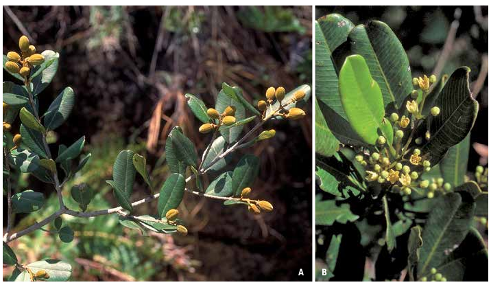
3. Abrahamia buxifolia (H. Perrier) Randrian. & Lowry View in CoL View at ENA , comb. nova ( Fig. 3 View Fig ).
≡ Protorhus buxifolia H. Perrier View in CoL in Mém. Mus. Natl. Hist. Nat. Paris 18: 258. 1944.
Lectotypus (designated here): MADAGASCAR. Prov. Toliara: Mt. Belambana , bassin du Mananara (Sud), [22°08’S 46°21’E], 1000 m, VII.1910, Perrier de la Bâthie 5852 ( P [ P06775177 ]!; GoogleMaps isolecto-: P [ P00722637 ]!) GoogleMaps . Syntypi: MADAGASCAR. Prov. Fianarantsoa: massif de l’Andringitra , [22°13’S 47°01’E], c. 1800 m, IV.1921, fr., Perrier de la Bâthie 13696 ( P [ P00722638 ]!) GoogleMaps . Prov. Toliara: Mont Vohipolaka, N Betroka , [22°08’S 46°21’E], 1100-1300 m, XI.1933, ster., Humbert 11637bis ( P [ P06775327 ]!) GoogleMaps ; ibid. loco, 1100-1200 m, Humbert 11667bis ( P [ P00722639 ]!). GoogleMaps
Description
Trees 2-7 m tall, bark with white milky latex; young twigs pubescent or glabrescent, lenticellate or waxy. Leaves subopposite or opposite; blades obovate to elliptic, 1.5- 6.8 3 1-2.7 cm, subcoriaceous, apex retuse or rounded, margin entire, base cuneate, adaxial surface glabrous, glaucous, often chocolate brown when dry, abaxial surface glabrous (except for sericeous indument on the midvein, and sometimes scattered indument elsewhere on the blade), venation craspedodromous, midvein prominent abaxially, secondary veins 15-25 pairs (rarely to 36 pairs), 1-3 mm apart, prominent on both surfaces, tertiary veins raised on both surfaces; petiole 5-7 mm long, c. 1-1.1 mm in diam., shallowly canaliculate on adaxial surface, glabrescent or pubescent. Inflorescences axillary and terminal, a thyrse, 1.5-4.5 cm long, pubescent. Male and female flowers 5-merous; pedicel c. 0.2-0.3 mm long, pubescent; calyx lobes deltate to widely depressed ovate, 1-1.2 3 1-1.5 mm, valvate, persistent on fruit, adaxial surface glabrous, abaxial surface pubescent; corolla lobes ovate, 2-3 3 1.5-2 mm, pale yellow, imbricate, adaxial surface glabrous, abaxial surface pubescent. Male flowers with 5 or 6 stamens, filaments c. 1-1.5 mm long, glabrous or with sparse indument, white, anthers c. 0.8 mm long, obloid to slightly ovoid, yellow, glabrous; disk c. 2 mm in diam., glabrous; ovary rudimentary. Female flowers with 5 or 6 staminodes, filaments c. 1 mm long, glabrous, white, anthers c. 0.5 mm long, ovoid, sterile, yellowish, glabrous; disk c. 1.5 mm in diam., glabrous; ovary widely ovoid, 1-2 3 1-1.5 mm, pubescent; style shortly trifid, inserted apically, c. 1 mm long, pubescent, stigmas capitate. Fruits c. 1.5 3 1.1 cm, ellipsoid to slightly obovoid, surface smooth, velutinous when young, glabrescent.
Vernacular names
“Sohihy’’.
Distribution, ecology and phenology
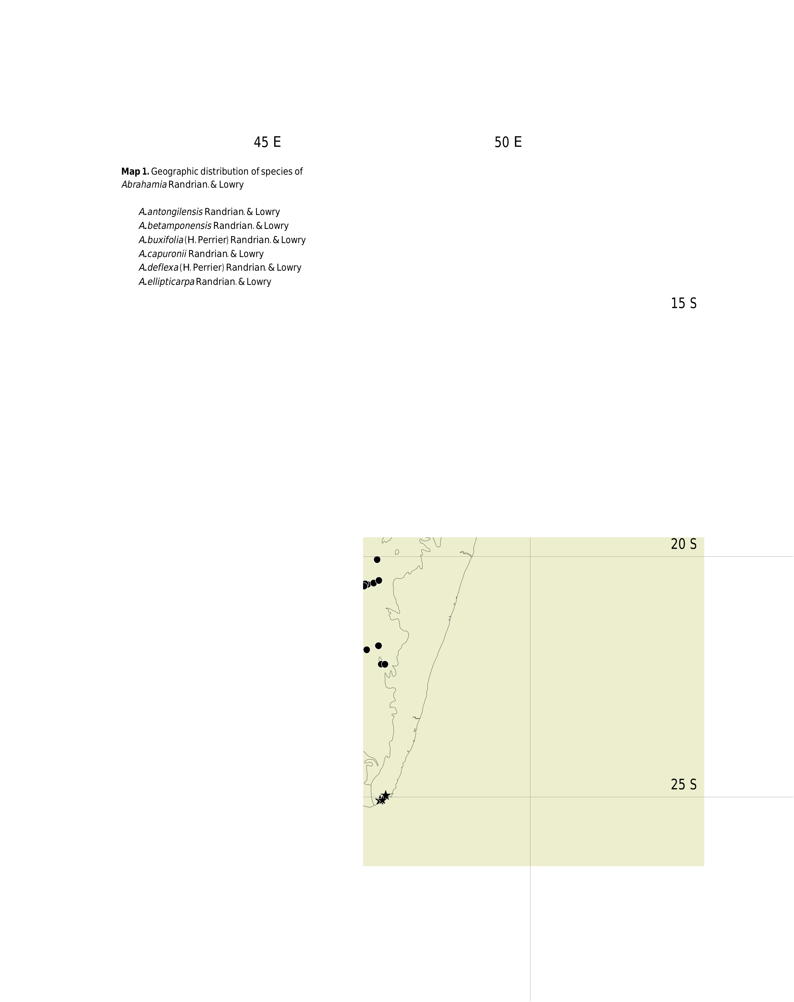
Abrahamia buxifolia occurs in the southern and southwestern parts of central Madagascar, with populations extending toward the western slopes and the eastern escarpment ( Map 1 View Map 1 ). It grows at elevation between 900-1800 m in areas where ecological conditions are harsh, including low rainfall and poor soils. It flowers in September and October, and sets fruits between November and February.
Conservation status
With an EOO of 37,259 km ², a minimum AOO of 60 km ², and 18 recorded localities, most of which are subjected to frequent burning and only 3 of which are within protected areas (Andringitra, Ibity, and Itremo), representing 11 locations, A. buxifolia is assigned a preliminary conservation status of “Near Threatened’’ [NT] using the IUCN Red List Categories and Criteria ( IUCN, 2012).
Notes
Abrahamia buxifolia can easily be distinguished from its most similar congener, A. itremoensis , by its glaucous and subcoriaceous leaves (vs non-glaucous and coriaceous) that are somewhat larger in size (1.5-6.8 3 1-2.7 vs 2-6 3 0.6-2 cm), and by its flowers with a glabrous disk (vs with evident indument).
Of the four collections cited in the protologue that we examined, we have selected Perrier de la Bâthie 5852 as the lectotype because it is more complete than the other syntypes and is represented by two specimens, whereas each of the three other syntypes comprises only a single sheet, two of which (Humbert 11637bis and Humbert 11667bis) are sterile and one (Perrier de la Bâthie 13696) has just a few fruits. Two other collections were also mentioned in the protologue (Decary 13041 and Humbert 14048) but we have not been able to find these specimens (although a sheet of the latter is reported to be at US) and we have not listed them below in the material examined.
The label data for Service Forestier 23500 and 23501 indicate a trunk diameter of 0.5 m, a value that far exceeds any observation we have made in the field. We therefore regard this as a label error and have not included this information in the description.
Additional material examined
MADAGASCAR. Prov. Antananarivo: Antsirabe, Betafo , Antakoboka , 20°03’46’’S 46°49’30’’E, 1807 m, 17.IX.2004, y. fl., Andriamihajarivo 371 ( G, MO, P, TAN, TEF) GoogleMaps ; forêt d’Analandraisoa ( SW Tsiroanimandidy), [19°09’S 45°49’E], 1200-1300 m, 17-20. XI.1952, fr., Leandri 1852 ( G, MO, P [2 sheets], TAN) GoogleMaps ; Mont Ibity, E slope of Kibory , 20°06’S 46°59’E, 1600 m, 2.X.1996, ster., A. Randrianasolo 488 ( MO, P, TAN) GoogleMaps ; Tsiroanomandidy, forêt d’Analandraisoa , [18°59’30’’S 45°41’30’’E], c. 1100 m, XI.1952, fr., Service Forestier 6726 ( G, MO, P, TEF) GoogleMaps . Prov. Fianarantsoa: Ambatofinandrahana, Itremo , forêt d’Antsirakambiaty , 20°35’42’’S 46°33’55’’E, 1605 m, 11.XII.2003, fr., Andriamihajarivo 258 ( G, MO, P, TAN) GoogleMaps ; Lovokaloha , 20°29’58’’S 46°51’37’’E, 1411 m, 2.XI.2004, fr., Andriamihajarivo 408 ( G, MO, P, TAN) GoogleMaps ; Ambatofinandrahana, 10 km N de RN 35, Antanimena , 20°31’05’’S 46°34’02’’E, 1541 m, 24.VIII.2010, fr., Andrianaivoravelona et al. 363 ( K, MO, TAN) GoogleMaps ; entre Ambatofinandrahana et Itremo , [20°33’S 46°45’E], IX.1956, bud, Bosser 10037 ( MO, P [3 sheets], TAN) GoogleMaps ; Itremo , [20°32’S 46°33’E], 1600 m, IX.1956, bud, Bosser 10075 ( P, TAN) GoogleMaps ; Inselbergs, PK 475, W of Ambalavao , 950-1050 m, 1.II.1975, fr., Croat 30326 ( MO) ; N of Sendrisoa , c. 1200 m, 23.II.1975, fr., Croat 32165 ( MO, P, TAN) ; Itremo massif, along Ambalo-ranogolana creek, 20°34’31’’S 46°34’50’’E, 1500 m, 9.XI.2002, y. fr., Lowry et al. 5861 ( G, MO, P, TAN) GoogleMaps ; Itremo massif, montane forest on quartz, 20°34’40’’S 46°34’53’’E, 1550 m, 29.X.1997, fl., Malcomber et al. 2849 ( G, MO, P, TAN); GoogleMaps Anja Parc, Inselberg Ambohilady , 21°51’11’’S 46°51’14’’E, 1224 m, 10.XII.2010, fr., Ramahefaharivelo 272 ( G, MO, P, TAN); GoogleMaps Itremo chain, W of Itremo village, 20°35’00’’S 46°36’10’’E, 1500 m, 4.X.1996, fl., A. Randrianasolo 489 ( G, MO, P, TAN); GoogleMaps ibid. loco, 1450 m, 6.X.1996, bud, A. Randrianasolo 493 ( G, MO, P, TAN); Ambalavao, Sendrisoa , [22°07’S 46°49’E], 15.XI.1953, fr., Réserves Naturelles 5858 ( P, TEF); GoogleMaps Ivohibe, [ Ivohibe RN], Antambohobe , 12.IX.1962, bud, Réserves Naturelles 12154 ( P); forêt Ambondrozana, Ihosy , [21°57’S 46°36’E], 17.II.1955, bud, Service Forestier 13771 ( P, TEF); GoogleMaps massif granitique d’Ifandana , entre Ankaramena et Ihosy , [22°01’00’’S 46°22’30’’E], 1300-1400 m, 7.X.1964, fl., Service Forestier 23500 ( G, MO, P [2 sheets], TEF); GoogleMaps ibid. loco, Service Forestier 23501 ( G, MO, NY, P, TEF); massif d’Iandrambaky , SW d’Iarintsena (Ambalavao), [21°51’S 46°51’E], 4.XI.1967, y. fr., Service Forestier 27830 ( G, MO, P, TEF); GoogleMaps rocher de l’Ifandana , N de Zazafotsy , [22°01’00’’S 46°22’30’’E], 2.XII.1968, fr., Service Forestier 28473 ( G, K, MO, NY, P [2 sheets], TEF); GoogleMaps Ambatofinandrahanana, Andranomivoaka , 18.III.1952, ster., Service Forestier 45-R-207 ( P); Ambalavao, forêt d’Amboandrozana , 9.VI.1954, ster., Service Forestier 63-R-141 ( P).
| TEF |
TEF |
| P |
Museum National d' Histoire Naturelle, Paris (MNHN) - Vascular Plants |
| G |
Conservatoire et Jardin botaniques de la Ville de Genève |
| MO |
Missouri Botanical Garden |
| TAN |
Parc de Tsimbazaza |
| TEF |
Centre National de la Recherche Appliquée au Developement Rural |
| A |
Harvard University - Arnold Arboretum |
| N |
Nanjing University |
| K |
Royal Botanic Gardens |
| W |
Naturhistorisches Museum Wien |
| NY |
William and Lynda Steere Herbarium of the New York Botanical Garden |
No known copyright restrictions apply. See Agosti, D., Egloff, W., 2009. Taxonomic information exchange and copyright: the Plazi approach. BMC Research Notes 2009, 2:53 for further explanation.
|
Kingdom |
|
|
Phylum |
|
|
Class |
|
|
Order |
|
|
Family |
|
|
Genus |
Abrahamia buxifolia (H. Perrier) Randrian. & Lowry
| Randrianasolo, Armand, Lowry II, Porter P. & Schatz, George E. 2017 |
Protorhus buxifolia
| H. Perrier 1944: 258 |