
Abrahamia phillipsonii Randrian. & Lowry, 2017
|
publication ID |
https://doi.org/ 10.5281/zenodo.7618113 |
|
DOI |
https://doi.org/10.5281/zenodo.7615557 |
|
persistent identifier |
https://treatment.plazi.org/id/038887C6-FFBB-FFA1-FE43-83651BE90F53 |
|
treatment provided by |
Carolina |
|
scientific name |
Abrahamia phillipsonii Randrian. & Lowry |
| status |
sp. nov. |
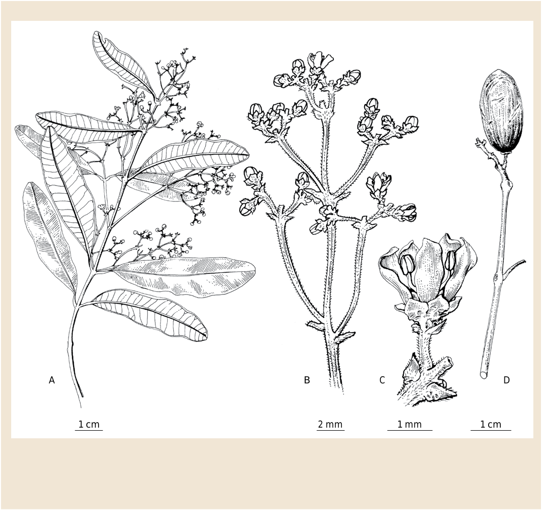
27. Abrahamia phillipsonii Randrian. & Lowry View in CoL View at ENA , spec. nova ( Fig. 23-24 View Fig View Fig ).
Typus: MADAGASCAR. Prov.Toliara:Rég. Androy , Andohahela PN,parcelle2, 24°50’S 46°32’E, 100 m, 7.XII.1988, fr., Phillipson 2853 (holo-: MO- 3767006 !; GoogleMaps iso-: K, P [ P06775412 ]!, TAN [ TAN001997 View Materials ]!, US-3661611 image seen, WAG [ WAG1523550 View Materials ] image seen). GoogleMaps
Diagnosis
Abrahamia phillipsonii Randrian. & Lowry most closely resembles A. lenticellata , with which its range overlaps, but can be easily distinguished by its craspedodromous (vs semicraspedodromous) venation, flowers borne in thyrses (vs panicles), and glabrous (vs velutinous) fruits.
Description
Trees 3-12(-20) m tall, 12-30 cm DBH, bark with white latex; young twigs glabrous or pubescent (sometimes ferruginous). Leaves alternate or subopposite; blades oblanceolate to obovate or narrowly elliptic to narrowly oblong, 2.6-7.8 3 0.6-2(-2.2) cm, chartaceous to subcoriaceous, apex emarginate, retuse or rounded, sometimes acute, margin entire, base acute or cuneate, adaxial surface glabrous, very often waxy, abaxial surface with very sparse indument, slightly more appressed on the midvein, nearly glabrous otherwise, venation craspedodromous, midvein prominent abaxially, secondary veins 11-19 (-23) pairs, prominent abaxially, 1-5 mm apart, tertiary veins rarely visible on both surfaces; petiole c. 0.5-10 mm long, glabrous, canaliculate on adaxial surface. Inflorescence axillary or terminal, a thyrse, 1.5-5.5 cm long, the axes flattened, with short, appressed, ferruginous or reddish indument. Male flowers 5-merous; calyx lobes widely depressed ovate to depressed ovate or triangular, 0.8-1 3 1-1.5 mm, valvate, glabrous, persistent on fruits; corolla lobes ovate, 2-2.2 3 1-1.5 mm, imbricate, glabrous, stamens 5, filaments c. 1.5 mm long, white, glabrous, anthers 0.8-1 mm long, ovoid to subglobose, yellow, glabrous; disk 1-1.2 mm in diam., glabrous; ovary rudimentary. Female flowers unknown. Fruits 1.5-2 3 1-1.3 cm, obovoid to ellipsoid, glabrous, with longitudinal striations.
Etymology
The species epithet honors our friend and colleague Peter. B. Phillipson, whose work has contributed so much to our knowledge of the Malagasy flora, including that of the drier parts of the island, where he has conducted most of his field work over the last three decades.
Vernacular names
“Manantsadrano’’, “Tarantantily’’, “Tsitaké’’.
Distribution, ecology and phenology
Abrahamia phillipsonii is restricted to sub-arid southern Madagascar ( Map 8 View Map 8 ), where it occurs at elevations between 100 and 1100 m. Flowering material has been collected between September and November, and fruits have been gathered from December through February. However, in drought years flowering can be delayed, which accounts for the limited number of collection with flowers gathered in March and April.
Conservation status
With an EOO of 64,857 km 2, a minimum AOO of 112 km 2, and 29 recorded localities, with subpopulations in 4 protected areas (Analavelona, Andohahela, Isalo, and Zombitsy), A. phillipsonii is assigned a preliminary conservation status of “Least Concern’’ [LC] using the IUCN Red List Categories and Criteria ( IUCN, 2012).
Notes
Abrahamia phillipsonii vegetatively most closely resembles A. deflexa , but it differs by its oblanceolate to obovate, narrowly elliptic to narrowly oblong (vs ovate, oblong or elliptic) leaf blades and its axillary or terminal (vs only terminal) inflorescence.
Paratypi
MADAGASCAR. Prov. Fianarantsoa: Ihosy, Analalava forest , 2-3 km W of western boundary of Isalo PN, [22°35’38’’S 45°08’20’’E], 770 m, 18.V.2004, fr., Rogers et al. 456 ( G, K, MO, P, TAN) GoogleMaps ; massif de l’Isalo , [22°08’S 45°10’E], 20.XII.1968, fr., Service Forestier 28504 ( P, TEF) GoogleMaps ; Ranohira, PK 712, [22°38’S 45°20’E], 23.VII.1955, ster., Service Forestier 13889 ( MO, P, TEF) GoogleMaps ; Isalo , 20.VII.1954, ster., Service Forestier 135-R-141 ( P) ; Isalo, Benenitra , 8.VIII.1954, ster., Service Forestier 180-R-18 ( P) ; Isalo, Ranohira , 23.VII.1955, ster., Service Forestier 288-R-239 ( P) ; Ihosy , 30.X.1953, ster., Service Forestier 777-R-1 ( P) . Prov. Toliara: Tolagnaro, Andohahela PN, N du mont Apiky, [24°47’02’’S 46°43’12’’E], 708 m, 18.I.2007, fr., Andriamihajarivo 1156 ( MO, P, TAN, TEF) GoogleMaps ; Amboasary, fourré d’Ambatofotsy Masay , 24°18’16’’S 46°08’00’’E, 350 m, 11.XI.2008, fr., Andriamihajarivo et al. 1574 ( G, MO, P, TAN) GoogleMaps ; Sakaraha , forêt de Zombitsy, [22°48’S 44°41’E], XII.1959, fr., Bosser 13402 ( MO, P [2 sheets], TAN) GoogleMaps ; Andohahela PN, parcelle 3, [25°00’S 46°40’E], 17.XI.1990, fr., Dumetz 1413 ( MO, P, TAN) GoogleMaps ; vallée de Fiherenana , 300-500 m, 1-2.VIII.1928, fr., Humbert & Swingle 5063 (= Service Forestier 50) ( P) ; Betroka, Mont Vohipolaka , 1200-1400 m, XI.1933, ster., Humbert 11694ter ( P, TAN) ; Amboasary , entre Andohahela et l’Elakelaka, [24°45’S 46°43’E], 700 m, I-II.1934, fr., Humbert 13770 ( P) GoogleMaps ; entre Andohahela et l’Elakelaka, mont Apiky , [24°45’30’’S 46°43’30’’E], 800-900 m, I-II.1934, fr., Humbert 13850 ( G, P [2 sheets]) GoogleMaps ; Beroroha, bassin de la Malio, [21°58’S 45°15’E], 400-450 m, 23-27.XI.1946, bud, Humbert 19403 ( P) GoogleMaps ; forêt de Zombitsy , [22°48’S 44°41’E], 600-850 m, 26-29.III.1955, fl. & bud, Humbert 29595 ( G, MO [2 sheets], P) GoogleMaps ; Beronono-Makay , 21°18’48’’S 45°08’55’’E, 531 m, 16.I.2010, fr., Rakotovao et al. 5117 ( MO, P, TAN) GoogleMaps ; PN Andohahela, Isaka Ivondro , 24°48’S 46°52’E, 100-500 m, 16-24.III.1993, Randriamampionona 202 ( G, MO, P, TAN) GoogleMaps ; PN Andohahela , parcel 3, 25°04’S 46°41’E, 100-300 m, 8-10.IV.1993, y. fr., Randriamampionona 285 ( G, MO, P, TAN) GoogleMaps ; Andohahela PN, parcel 1, Tsimelahy , 24°50’20’’S 46°32’17’’E, 6.IV.1996, ster., Randriamampionona 1259 ( MO, TAN) GoogleMaps ; Sakaraha, Mahaboboka, Ambinanintelo , forêt d’Analavelona , 22°41’14’’S 44°09’32’’E, 961 m, 3.XII.2016, fr., Randrianarivony et al. 745 ( MO, P, TAN) GoogleMaps ; PN Andohahela , parcelle n° 3, [25°04’S 46°41 E], 100-300 m, 19.X.1990, fl., A. Randrianasolo 181 ( MO [2 sheets], P, TAN, TEF) GoogleMaps ; Sakaraha, at start of Kinanamboribory valley , 22°39’44’’S 44°11’02’’E, 1208 m, 8.XII.2009, fr., A. Randrianasolo 1246 ( G, MO, P, TAN) GoogleMaps ; Ambatoabo , 5 km N d’Imonty, 24°46’44’’S 46°42’56’’E, 500 m, 25.XI.2009, fr., Ratovoson 1534 ( G, K, MO, P, TAN) GoogleMaps ; Betorabato, Abotorabatorano , 21°34’04’’S 45°34’34’’E, 296 m, 13.I.2011, fr., Razakamalala 6000 ( G, MO, P, TAN) GoogleMaps ; Ankomaka , [22°36’S 44°02’E], 26.I.1952, fr., Service Forestier 4556 ( P, TEF); GoogleMaps forêt de Zombitsy , [22°46’S 44°42’E], 24.IV.1953, fl., Service Forestier 7757 ( P, TEF) GoogleMaps ; env. de Tsimela , S d’Ambatoabo , [24°56’S 46°38’E], 28.IX.1953, fl., Service Forestier 8523bis ( G, NY, MO, P, TEF) GoogleMaps ; forêt de Zombitsy , [22°46’30’’S 44°38’00’’E], III.1931, fl., Service Forestier 11931 ( G, MO, P) GoogleMaps ; Analavelona , [22°40’S 44°10’E], 25.XI.1954, fr., Service Forestier 12089 ( P, TEF) GoogleMaps ; ibid. loco, 28.XI.1954, fr., Service Forestier 12140 ( P, TEF) GoogleMaps ; Betioky , vallée Sakamarakely, [22°11’S 45°10’E], 14.XI.1954, fr., Service Forestier 12362 ( P) GoogleMaps ; Zombitsy , [22°46’S 44°42’E], 7.XI.1954, fl., Service Forestier 12428 ( P [2 sheets], TEF) GoogleMaps ; Ambovombe , Beanantara, [25°03’30’’S 46°12’30’’E], 17.IX.1955, fl., Service Forestier 15656 ( P, TEF) GoogleMaps ; Ampolitsy , Beroroha, [21°40’30’’S 45°10’E], 16.IV.1956, y. fr., Service Forestier 15800 ( P, TEF) GoogleMaps ; Amboasary , bush entre Bevilany et Ranomainty, [25°00’S 46°34’E], 1.XII.1961, fr., Service Forestier 20481 ( P [2 sheets], TEF) GoogleMaps ; crête du massif de l’Angavo , [24°50’30’’S 45°48’00’’E], c. 500 m, 21.I.1963, fr., Service Forestier 22487 ( P, TEF) GoogleMaps ; Zombitse, Andranolava , 13.V.1954, ster., Service Forestier 27-R-224 ( P) ; Kitranga, Ihosy , 25.VIII.1955, ster., Service Forestier 43-R-230 ( P) ; Analavelona, 7.IV.1954, ster., Service Forestier 76-R-18 ( P) ; forêt de Zombitsy , 26.II.1955, ster., Service Forestier 86-R-161 ( P) ; forêt d’Ihera , 25.IV.1955, ster., Service Forestier 104-R-161 ( P) ; ibid. loco, 9.IV.1954, ster., Service Forestier 108-R-18 ( P) ; Bejangoa, Ankazoabo , 25.V.1954, ster., Service Forestier 112-R-13 ( P) ; env. d’Ampandrandava (entre Bekily et Tsivory), [24°05’S 45°42’E], 1100 m, XI.1942, fl., Seyrig 265 ( P [2 sheets]) GoogleMaps ; ibid. loco, Seyrig 265 B ( MO, P). GoogleMaps


| WAG |
WAG |
| TEF |
TEF |
| K |
Royal Botanic Gardens |
| P |
Museum National d' Histoire Naturelle, Paris (MNHN) - Vascular Plants |
| TAN |
Parc de Tsimbazaza |
| WAG |
Wageningen University |
| G |
Conservatoire et Jardin botaniques de la Ville de Genève |
| MO |
Missouri Botanical Garden |
| TEF |
Centre National de la Recherche Appliquée au Developement Rural |
| NY |
William and Lynda Steere Herbarium of the New York Botanical Garden |
| B |
Botanischer Garten und Botanisches Museum Berlin-Dahlem, Zentraleinrichtung der Freien Universitaet |
No known copyright restrictions apply. See Agosti, D., Egloff, W., 2009. Taxonomic information exchange and copyright: the Plazi approach. BMC Research Notes 2009, 2:53 for further explanation.
|
Kingdom |
|
|
Phylum |
|
|
Class |
|
|
Order |
|
|
Family |
|
|
Genus |