
Abrahamia grandidieri (Engl.) Randrian. & Lowry
|
publication ID |
https://doi.org/ 10.5281/zenodo.7618113 |
|
DOI |
https://doi.org/10.5281/zenodo.7618400 |
|
persistent identifier |
https://treatment.plazi.org/id/038887C6-FF89-FF93-FE43-83651DF20CB9 |
|
treatment provided by |
Carolina |
|
scientific name |
Abrahamia grandidieri (Engl.) Randrian. & Lowry |
| status |
|
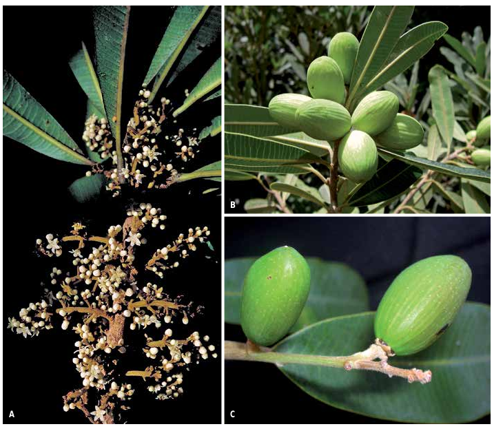
11. Abrahamia grandidieri (Engl.) Randrian. & Lowry View in CoL View at ENA , comb. nova ( Fig. 10 View Fig B-C).
≡ Protorhus grandidieri Engl. View in CoL in Bot. Jahrb. Syst. 1: 422. 1881.
≡ Rhus grandidieri (Engl.) Baill. View in CoL in Grandid., Hist. Phys. Madagascar Atlas: tab. 233. 1892.
Typus: MADAGASCAR. Prov. Toliara: Morondava, s.d., fl., Grevé s.n. (holo-: P [ P00722643 ]!; iso-: P [ P00722644 ]!) .
= Rhus venulosa View in CoL Baker in J. Linn. Soc., Bot. 25: 309. 1890. Typus: MADAGASCAR: N Androna , s.d., fl., Baron 5756 (holo-: K [ K 000423274 ] image seen) .
= Protorhus heckelii Dubard & Dop View in CoL in Bull. Soc. Bot. France 54: 155. 1907. Typus: MADAGASCAR. Prov. Mahajanga: bords des ruisseaux, Ambongo et Boeny, IX.1904, bud & y. fr., Perrier de la Bâthie 859 (holo-: P [ P06775232 ]!).
Description
Trees 4-20 m tall, 20-45 cm DBH, bark with milky white latex; young twigs pubescent, with lenticels. Leaves alternate, rarely subopposite; blades oblanceolate or narrowly oblong, 3-16 3 1.5-4 cm, subcoriaceous, apex emarginate, retuse or rounded, margin entire, base acute or cuneate, adaxial surface glaucous, glabrous or sometimes with sericeous indument, especially on and alongside the midvein, abaxial surface with appressed sericeous indument, more so on and alongside the midvein, venation craspedodromous, midvein prominent abaxially, secondary veins 35-40(-47) pairs, parallel, 0.5-5 mm apart, tertiary veins barely visible on both surfaces; petiole 5-15 mm long, canaliculate on adaxial surface, pubescent or glabrescent. Inflorescence axillary or terminal, a panicle, 1.5-16 cm long, pubescent or villous. Male and female flowers 5-merous; pedicel 0-0.5 mm long, pubescent; calyx lobes deltate, 1-1.2 3 c. 1 mm, imbricate, adaxial surface glabrous, abaxial surface pubescent, persistent on fruit; corolla lobes ovate, 2-2.5 3 1-1.5 mm, imbricate, adaxial surface glabrous, abaxial surface pubescent, white to light yellow or yellow green; stamens 5. Male flowers with filaments 1-1.2 mm long, glabrous, white, anthers 0.5 mm long, ovoid to subglobose, yellow, glabrous; disk c. 1 mm in diam., glabrous; ovary rudimentary. Female flowers with filaments 1-1.3 mm long, glabrous, white, anthers 0.5 mm long, subglobose or ovoid, sterile, yellow, glabrous; disk 1-1.5 mm in diam., glabrous; ovary depressed ovoid, slightly asymmetrical, c. 1 3 1-1.2 mm, glabrous, placentation subapical; style shortly trifid, inserted apically, c. 1 mm long, glabrous. Fruits 2-2.8 3 1.1-1.7 cm, ellipsoid, slightly asymmetrical, glabrous, with longitudinal striations.
Vernacular names
“Ditimena’’, “Lakalaka’’, “Manavodrevo’’, “Sandramiramy’’, “Soahihy’’, “Sohihy’’, “Sohy’’.
68 Boissiera 71
Distribution, ecology and phenology
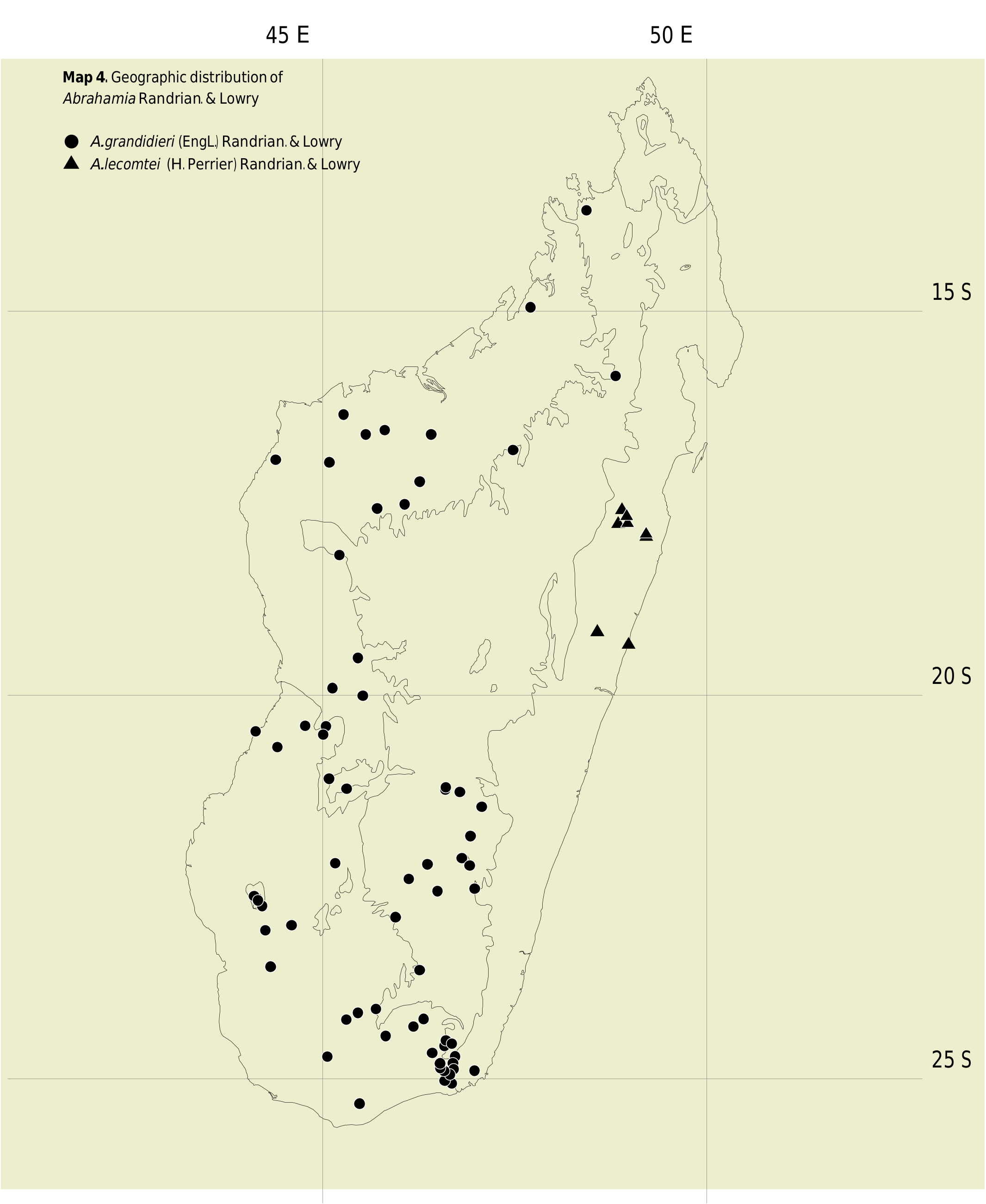
Abrahamia grandidieri occurs in western and southern Madagascar ( Map 4 View Map 4 ), at elevations ranging from sea level to 1,500 m, and is very often found near rivers or streams. It flowers from August to November and fruits from November through January.
Conservation status
With an EOO of 412,300 km 2, a minimum AOO of 272 km 2, and 70 known localities, including subpopulations in 6 protected areas (Analavelona, Andohahela, Andringitra, Bemarivo, Namoroka, and Pic d’Ivohibe), A. grandidieri is assigned a preliminary conservation status of “Least Concern’’ [LC] using the IUCN Red List Categories and Criteria ( IUCN, 2012).
Notes
Abrahamia grandidieri most closely resembles A. sericea , with which it shares leaves with parallel and very closely spaced secondary veins, but can easily be distinguished by its narrower leaves that are glaucous (vs broader and not glaucous), its flowers with a glabrous (vs pubescent) disk and ovary, and its glabrous (vs velutinous) fruits.
While the protologue of Protorhus heckelii indicates that it is based on “ Perrier de la Bâthie, no. 3, in Herb. Mus”, it is clear that the authors prepared their description using the specimen of Perrier de la Bâthie 859 that bears the original label written in Perrier’s hand [P06775232], along with another label added later that indicates “No. 3 = 859 Perrier de la Bâthie”. Curiously, this specimen also bears a note added some time later by Perrier that reads “Ces spécimens proviennent d’une autre localité que le no. 859 (les bords de l’Iubohago près de l’Ankirihitra (Boina)”. A second specimen in the Paris herbarium [P06775233], comprising a single leaf and a small part of an inflorescence in a fragment packet on which someone (clearly not Perrier) has indicated “ Protorhus (au sp. nov.). Madagascar. M. Perrier de la Bâthie, envoyé par Mr. Heckel au Lab. Colonial, fin 1906”, which appears to have been the basis for the choice of the epithet used by Dubard and Dop. This second specimen does not have an original label, but it does bear a note in Perrier’s hand, dated October 1947, that reads “Perrier no. 859! Type (?) de Protorhus Heckelei Dub. & Dop , récolté sur les bords de la Boina Kely, petit affluent de droite de la Betsiboka, à l’est de Mevatenana (Boina)”. It is not clear whether Dubard and Dop examined this specimen, and because according to Perrier de la Bâthie it is not part of the same gathering as the holotype, we have refrained from regarding it as either an isotype or a syntype.
Additional material examined
MADAGASCAR. Prov. Antsiranana: Antsiranana, bord de la rivière Betsieka , I.1938, ster., Humbert 19093ter ( P) ; Ambanja , Beampongy , [13°40’30’’S 48°27’00’’E], 4.X.1953, Service Forestier 7715 ( P, TEF) GoogleMaps ; Befandriana-Nord, Marosakana , le long de la rivière Tsinjomolava, [14°56’S 47°40’E], 11.IX.1956, fl., Service Forestier 16094 ( P, TEF) GoogleMaps . Prov. Fianarantsoa: Ihosy, entre Ankaramena et Zazafotsy , [22°12’S 46°22’E], 9.X.1966, fl., Boiteau 339 ( G, MO, P) GoogleMaps ; ibid. loco, Boiteau 341A-C ( P) GoogleMaps ; Ambalavao, entre Vohitromby et Vohitrosy , [21°50’S 46°56’E], 8.XII.1974, fr., Cremers 3547 ( P [2 sheets], TAN) GoogleMaps ; entre Ihosy et Fianarantsoa, 9. VIII.1938, ster., Grandidier s.n. ( P) ; env. d’Ihosy , [22°23’00’’S 46°07’30’’E], 800-900 m, III.1934, ster., Humbert 14452ter ( P) GoogleMaps ; Ambohimahasoa, Ikalamavony , [21°10’00’’S 46°35’30’’E], 1955, ster., Humbert 30255bis ( P) GoogleMaps ; RN Andringitra, Vohitsaoka , 17.IX.1951, fl. & bud, Réserves Naturelles 3112 ( P [2 sheets], TAN) ; ibid. loco, 8.XI.1952, bud, Réserves Naturelles 4802 ( P [2 sheets], TAN) ; ibid. loco, 27.IX.1957, fr., Réserves Naturelles 9300 ( P, TEF) ; Ivohibe , [22°31’30’’S 46°59’00’’E], 8.XI.1950, Service Forestier 1449 ( P, TAN, TEF) GoogleMaps ; forêt de Mangidy, [21°15’30’’S 46°47’30’’E], 15.X.1951, fl., Service Forestier 4726 ( P, TAN, TEF) GoogleMaps ; Fianarantsoa, forêt Isahafa, [21°27’00’’S 47°04’30’’E], 27.IX.1951, fl., Service Forestier 4762 ( P, TEF) GoogleMaps ; Maintinandrina , [21°15’30’’S 46°47’30’’E], 9.IX.1952, fl., Service Forestier 5958 ( P, TEF) GoogleMaps ; Ihosy , [22°23’00’’S 46°07’30’’E], 30.X.1953, bud, Service Forestier 7615 ( P, TEF) GoogleMaps . Prov. Mahajanga: bord de ruisseau, env. de Bekodoka , [16°58’E 45°06’E], 10.IX.1930, fl., Decary 8303 ( G, P, US) ; Bekodoka , [16°58’S 45°06’E], 19.IX.1930, fl., Decary 8096 ( P) GoogleMaps ; Ambanja , Forêt d’Andranomatavy, forêt dense humide, bord de rivière, 13°40’29’’S 47°59’12’’E, 123 m, 28.IX.2013, fl., Tahinarivony 746 ( G, MO, P, TAN) GoogleMaps ; Befandriana Nord, 14.IX.1942, fl., Herb. Jard. Bot. Tananarive 5253 ( P) ; Ambongo et Boeny , IX.1904, Perrier de la Bâthie 859 ( P) ; Antajiandava , Soalala , [16°33’S 45°49’E], 2.VIII.1951, bud, Service Forestier 3990 ( P, TEF) GoogleMaps ; Soalala , bassin moyen du Bemarivo , [17°34’S 45°43’E], IX.1907, fl., Perrier de la Bâthie 4519 ( P [2 sheets], TAN) GoogleMaps ; Bassin du Bemarivo , [16°56’S 44°24’E], c. 80 m, IX.1907, fl., Perrier de la Bâthie 5863 ( P [3 sheets]) GoogleMaps ; ibid. loco, Perrier de la Bâthie 5865 ( P) GoogleMaps ; plateau d’Ankara , [17°13’S 46°16’E], VIII.1922, bud, Perrier de la Bâthie 14825 ( P [2 sheets]) GoogleMaps ; env. de Mandritsara , [15°50’00’’S 48°49’30’’E], 600 m, IX.1922, fr., Perrier de la Bâthie 15047 ( P) GoogleMaps ; Tsaratanana , forêt de Koakala, 16°48’09’’S 47°28’58’’E, 385 m, 7.XII.2003, fr., A. Randrianaivo et al. 994 ( CNARP, MO, P, TAN) GoogleMaps ; Namoroka RN, Andranomavo , [16°36’S 45°34’E], 10. IV.1952, ster., Réserves Naturelles 3888 ( P [2 sheets]) GoogleMaps ; ibid. loco, 8.IX.1956, fl., Réserves Naturelles 8139 (= Service Forestier 17172) ( P, TEF) GoogleMaps ; ibid. loco, 17.XI.1960, fr., Réserves Naturelles 11437 ( P) GoogleMaps ; Maevatanana, Ankaboka , Ambalajanakomby , [17°30’50’’S 46°04’30’’E], 8.I.1955, fr., Service Forestier 13034 ( P, TEF) GoogleMaps ; Morafenobe , Beravina , [18°10’30’’S 45°13’30’’E], 19.VIII.1956, fl., Service Forestier 16351 ( P, TEF) GoogleMaps ; Befandriana Nord, Canton Ambararata , [16°36’S 46°25’E], 16.I.1959, fr., Service Forestier 19403 ( P, TEF) GoogleMaps . Prov. Toliara: PN Andohahela , 24°56’23’’S 46°38’40’’E, 120 m, 9-12.V.1997, fr., Birkinshaw et al. 421 ( MO, P, TAN) GoogleMaps ; Rivière de l’Onilahy, E de Maromala, s.d., y. fr., Geay 6053 ( P) ; Betroka, Ampandrandava , 8. IV.1942, y. fr., Herb. Jard. Bot. Tananarive 4971 ( P) ; Bekily, Ampandrandava , IX-X.1943, bud & fl., Herb. Jard. Bot. Tananarive 5793 ( P) ; Andohahela PN, Talakimangery , 24°51’47’’S 46°42’34’’E, 250-500 m, 10.X.2000, fl., Hoffmann et al. 172 ( G, K, P) GoogleMaps ; Betioky, vallée de l’Onilahy , env. de Tongobory, [23°32’S 44°20’E], 100-200 m, 1-8.X.1924, Humbert 2699 ( G, P) GoogleMaps ; Amboasary, vallée de la Menarahaka , [22°33’S 46°30’E], 700-800 m, 31.X.1924, fl. & fr., Humbert 3046 ( P) GoogleMaps ; près de Bevilany , [25°00’30’’S 46°36’E], 200-300 m, 14.IX.1928, fl., Humbert & Swingle 5712 ( P [2 sheets], TAN) GoogleMaps ; haute vallée du Mandrare , [24°39’S 46°26’E], 8-15. XI.1928, ster., Humbert 6487bis ( P) GoogleMaps ; Tsivory à Anadabolava , [24°12’40’’S 46°19’00’’E], 300- 400 m, XII.1933, fr., Humbert 12287 ( P [2 sheets]) GoogleMaps ; ibid. loco, 200 m, Humbert 12367 ( P [2 sheets]) GoogleMaps ; vallée de la Manambolo , env. d’Esomony, [24°32’S 46°41’E], 400-900 m, XII.1933, fr., Humbert 12882 ( G, P) GoogleMaps ; vallée de l’Onilahy , en aval de Tongobory, [23°31’30’’S 44°19’30’’E], 0-300 m, 8.XI.1960, ster., Leandri 3759 ( P) GoogleMaps ; Beroroha, Makay massif, 21°13’02’’S 45°19’08’’E, 480 m, 22.XI.2010, fr., Phillipson et al. 6188 ( G, K, MO, NY, P, TAN) GoogleMaps ; PN Andohahela, 22. IX.1994, fl., Rakotomalaza 273 ( G, K, MO, NY, P, TAN) ; PN Andohahela, 25°01’S 46°38’E, 15.V.2001, fr., Randriamampionona 1013 ( G, K, MO, NY, P, TAN, WAG) GoogleMaps ; ibid. loco, 24°50’20’’S 46°32’17’’E, 6.IV.1996, ster., Randriamampionona 1241 ( MO, TAN) GoogleMaps ; PN Andohahela, Eso-mony , coté W de la réserve, 24°31’S 46°37E, 20.IX.1991, fl., Randriamanantena & Durbin 58 ( MO, P, TAN) GoogleMaps ; Ambatoabo , forêt d’Ankoba, 24°47’28’’S 46°42’01’’E, 205 m, 24. XI.2008, fr., Randrianaivo 1716 ( G, K, MO, P, TAN) GoogleMaps ; Sakaraha, Mahaboboka , Marotsiraka Betsileo, 22°44’20’’S 44°13’24’’E, 594 m, 21.III.2011, fr., Randrianarivony et al. 294 ( G, MO, P, TAN) GoogleMaps ; Ranobe, Behalomboro , 24°18’28’’S 46°11’18’’E, 210 m, 1.XI.2007, fr., Randriatsivery 295 ( MO, P, TAN, TEF) GoogleMaps ; Ampasinampoana, Enato , 24°53’05’’S 46°58’52’’E, 425 m, 16.XII.2009, fr., Razakamalala et al. 5102 ( G, MO, P, TAN) GoogleMaps ; Betorabato , forêt d’Androtsy, 21°05’17’’S 45°05’39’’E, 235 m, 11.I.2011, fr., Razakamalala 5920 ( MO, P, TAN) GoogleMaps ; PN Andohahela, Behara , [24°48’S 46°32’E], 4.X.1951, fl., Réserves Naturelles 3407 ( MO, P [2 sheets], TAN) GoogleMaps ; Andohahela PN, Canton Enanihila , [24°31’S 46°37’E], 2. VIII.1952, y. fr., Réserves Naturelles 3958 ( P [2 sheets], TAN) GoogleMaps ; PN Andohahela, Behara , [24°53’S 46°35’E], 25.XI.1953, fr., Réserves Naturelles 5956 ( G, P [2 sheets], TEF) GoogleMaps ; Imanombo, Behara , [24°26’00’’S 45°49’30’’E], 16.IX.1950, fl. & y. fr., Service Forestier 1518 ( P, TAN, TEF) GoogleMaps ; Anapaby , [23°00’S 44°36’E], 1.X.1951, fl., Service Forestier 3862 ( P, TEF) GoogleMaps ; Morondava, Dabara , [20°24’S 44°47’E], 12.VIII.1951, bud, Service Forestier 3915 ( P) GoogleMaps ; Ranopiso , [25°03’00’’S 46°41’30’’E], 10.IX.1951, y. fr., Service Forestier 3967 ( P, TEF) GoogleMaps ; Betroka, Merarano , [20°30’30’’S 45°00’30’’E], 16.IX.1952, bud, Service Forestier 6337 ( P [2 sheets], TEF) GoogleMaps ; Belo sur Tsiribihina, Tsaramandroso , [19°54’30’’S 45°08’00’’E], 1. VII.1953, fr., Service Forestier 7797 ( MO, P, TEF) GoogleMaps ; Bekily , [24°13’20’’S 45°19’E], 14.I.1954, fr., Service Forestier 8392 ( P, TEF) GoogleMaps ; vallée de l’Onilahy , en aval de Tongobory, [23°31’30’’S 44°19’30’’E], 17.IX.1953, bud & fl., Service Forestier 8462 ( P, TEF) GoogleMaps ; Betroka, Benonoka-I , [23°33’30’’S 46°16’30’’E], 10.IV.1954, y. fr., Service Forestier 10199 ( P, TEF) GoogleMaps ; Sakaraha, Sohara , [24°08’S 45°28’E], 26.V.1954, y. fr., Service Forestier 10293 ( MO, P, TEF) GoogleMaps ; forêt de Befitroa, [20°00’30’’S 45°32’E], 20.IX.1954, fl., Service Forestier 10876 ( P [2 sheets], TEF) GoogleMaps ; km 455, route Ft. Dauphin , [25°02’00’’S 46°39’30’’E], 9.IX.1954, y. fr., Service Forestier 10907 ( MO, P, TEF) GoogleMaps ; Sakaraha, Bekily , [24°08’S 45°28’E], 25.XI.1954, fr., Service Forestier 11158 ( P, TEF) GoogleMaps ; Miandrivazo, Ankilimadinika , [19°31’S 45°28’E], 23.X.1954, ster., Service Forestier 11185 ( P, TEF) GoogleMaps ; Sakatà, Betroka , [22°53’30’’S 45°57’30’’E], 17. IX.1954, fl., Service Forestier 12124 ( P, TEF) GoogleMaps ; Manambolo , [24°34’S 46°36’E], 5.XI.1954, y. fr., Service Forestier 12199 ( P, TEF) GoogleMaps ; Sakamarakely , [22°11’S 45°10’E], 14.XI.1954, fr., Service Forestier 12363 ( P) GoogleMaps ; ibid. loco, Service Forestier 12364 ( P, TEF) GoogleMaps ; Vineta , [23°03’30’’S 44°15’30’’E], 20.XII.1955, fr., Service Forestier 15594 ( P, TEF) GoogleMaps ; Morondava, Canton Befasy , Tananadava , [20°28’S 44°08’E], 4.X.1956, fl., Service Forestier 16556 ( P, TEF) GoogleMaps ; Behara, Amboasary , [24°53’S 46°35’E], 3.X.1956, bud, Service Forestier 17038 [= Réserves Naturelles 7920] ( MO, P, TEF) GoogleMaps ; Mahabo, Canton Ankilizato , Migodo , [20°24’S 45°03’E], 4.XII.1957, fr., Service Forestier 17869 ( P, TEF) GoogleMaps ; Bekily, Ankaranabo-Sud , [24°13’S 45°19’E], 9.IX.1963, bud, Service Forestier 21370 ( P, TEF) GoogleMaps ; Bords des ruisseaux, versant W du massif de l’Analavelona , W de Mitia, [22°37’S 44°07’E], 15.XII.1962, fr., Service Forestier 22203 ( G, MO, P [2 sheets], TEF) GoogleMaps ; Tsihombe, Manindro , bord rivière Manambovo, [25°19’S 45°29’E], 27.IV.1967, y. fr., Service Forestier 26502 ( MO, P, TEF) GoogleMaps ; Ampanihy, Bekitro , Tranoroa , [24°42’S 45°04’E], 13.IX.1968, bud & fl., Service Forestier 26745 ( P, TEF) GoogleMaps ; Tanambao Befasy, [20°40’31’’S 44°25’E], 1.IX.1954, ster., Service Forestier 64-R-19 ( P, TEF); GoogleMaps Ampandrandava, [24°05’S 45°42’E], 700-800 m, IX.1942, fl., Seyrig 1 ( P [2 sheets]). GoogleMaps Sine loco: s.d., Baron 9796 ( P). GoogleMaps
| TEF |
TEF |
| CNARP |
CNARP |
| WAG |
WAG |
| P |
Museum National d' Histoire Naturelle, Paris (MNHN) - Vascular Plants |
| K |
Royal Botanic Gardens |
| TEF |
Centre National de la Recherche Appliquée au Developement Rural |
| G |
Conservatoire et Jardin botaniques de la Ville de Genève |
| MO |
Missouri Botanical Garden |
| TAN |
Parc de Tsimbazaza |
| A |
Harvard University - Arnold Arboretum |
| NY |
William and Lynda Steere Herbarium of the New York Botanical Garden |
| WAG |
Wageningen University |
No known copyright restrictions apply. See Agosti, D., Egloff, W., 2009. Taxonomic information exchange and copyright: the Plazi approach. BMC Research Notes 2009, 2:53 for further explanation.
|
Kingdom |
|
|
Phylum |
|
|
Class |
|
|
Order |
|
|
Family |
|
|
Genus |
Abrahamia grandidieri (Engl.) Randrian. & Lowry
| Randrianasolo, Armand, Lowry II, Porter P. & Schatz, George E. 2017 |
Rhus venulosa
| Baker 1890: 309 |
Protorhus grandidieri
| Engl. 1881: 422 |