
Psilota tristis Klocker, 1924
|
publication ID |
https://doi.org/ 10.11646/zootaxa.4737.1.1 |
|
publication LSID |
lsid:zoobank.org:pub:C38FB007-98AE-4E4C-8A18-B1C75588815E |
|
DOI |
https://doi.org/10.5281/zenodo.3671039 |
|
persistent identifier |
https://treatment.plazi.org/id/B33CB310-FFD4-3E15-FF51-FF54FA5061B7 |
|
treatment provided by |
Plazi |
|
scientific name |
Psilota tristis Klocker, 1924 |
| status |
|
Psilota tristis Klocker, 1924 View in CoL
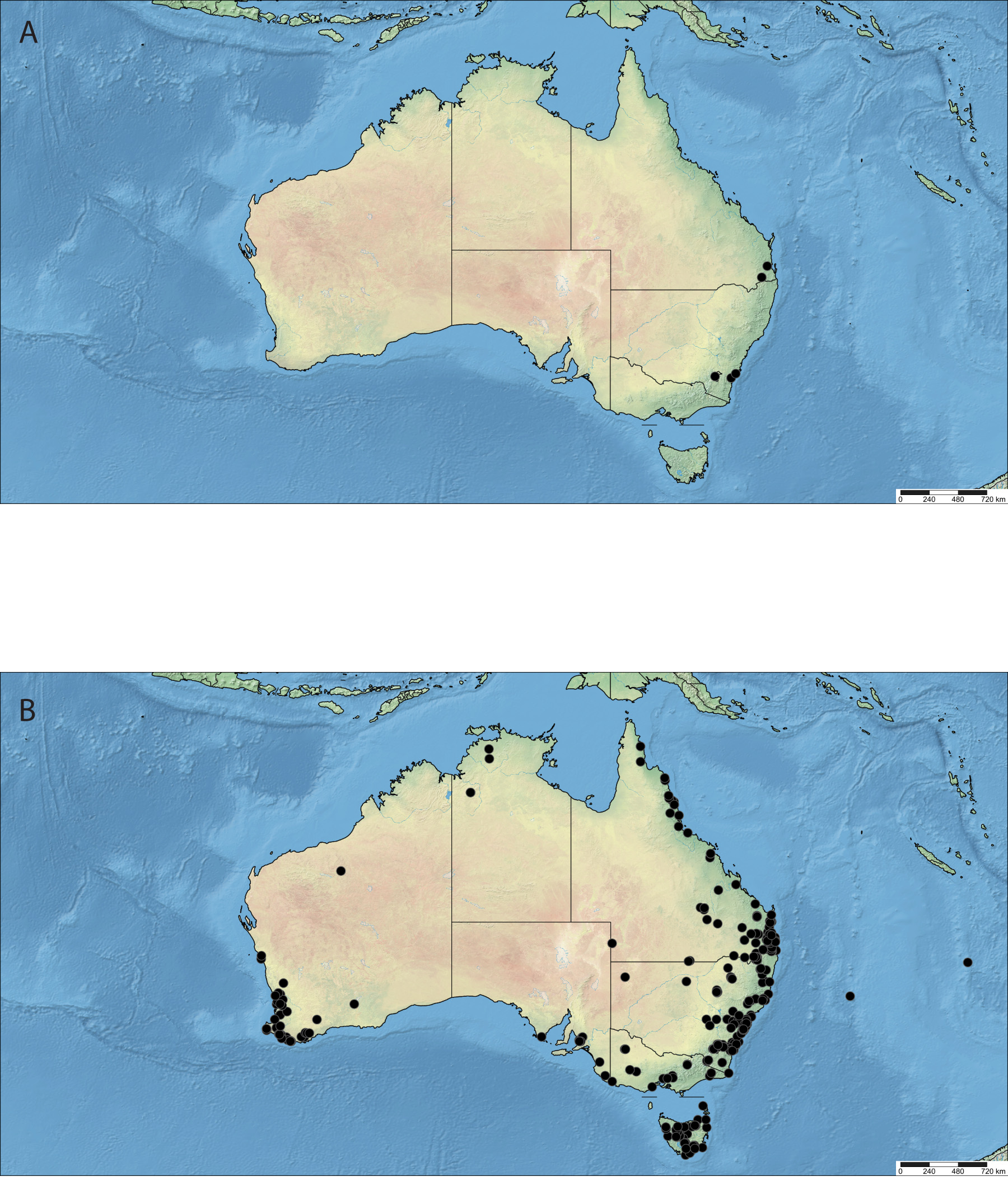
(Species plate: Fig. 35 View FIGURE 35 ; Map: Fig. 64B View FIGURE 64 )
Psilota tristis Klocker, 1924: 54 View in CoL . Type locality: Queensland, Australia
Diagnosis: Face black, pale pollinose, with dark or pale pile. Frons and vertex black pilose. Thorax black. Thoracic pile variable in colour. Hind leg simple. Calypter variable in colour. Halter variable in colour. Abdomen black. Tergite pile variable in colour. Body length: 7.0– 14.1 mm.
Description: MALE: Head: Head black, face pale pollinose. Face dark or pale pilose, frons and vertex black pilose. Antenna orange to dark brown. Postpedicel variable in shape. Eye densely brown pilose. Thorax: Thorax black. Legs mostly orange to entirely dark brown. Hind femur simple. Hind tibia simple. Pleuron densely grey pollinose to bare and shining. Pile pleuron variable in colour. Pile on scutum and scutellum variable in colour, but always at least partly black on scutellum (male only). Wing colourless. Wing microtrichia variable. Alula completely microtrichose. Halter variable in colour. Calypter variable in colour. Abdomen: Abdomen black. Pilosity of tergites variable in colour. Sternites black, with variably coloured pilosity. Genitalia: variable (see below).
FEMALE: Identical except for normal sexual dimorphism.
Specimens examined: AUSTRALIA: Australian Capital Territory: Bendora , -35.221814 149.169528, 13.ii.1952, S.J. Paramonov, ANIC29034513 About ANIC (1♀, ANIC) GoogleMaps Black Mountain , -35.266303 149.095464, 24.x.1977; 13.iii.1961; 13.x.1965; 15.xii.1963; 21.ii.1966; 18.i.1966; 21.xii.1962; 26.xi.1959; 28.x.1966; 30.x.1962; 30.x.1964; 30.x.1969; xii.1987, Z. Liepa; I.F.B. Common; M. Irwin, Malaise trap; light trap, ANIC29034495 About ANIC ; ANIC29034540 About ANIC ; ANIC29034868 About ANIC ; ANIC29034518 About ANIC ; ANIC29034932 About ANIC ; ANIC29034867 About ANIC ; ANIC29034517 About ANIC ; ANIC29034545 About ANIC ; ANIC29034551 About ANIC ; ANIC29034520-29034521 About ANIC ; ANIC29034534 About ANIC ; ANIC29034476 About ANIC ; ANIC29035781 About ANIC (7♂♂, 7♀♀, ANIC) GoogleMaps ; Blundell’s [Cabin], -35.292886 149.141800, 25.xii.1937; 11.x.1950; 24.x.1950, M. Fuller; Paramonov, ANIC29034811 About ANIC ; ANIC29034496 About ANIC ; ANIC29034467 About ANIC ; ANIC29034444 About ANIC ; USNM _ ENT249831-32 About USNM (2♂♂, 5♀♀, ANIC, USNM) GoogleMaps ; Canberra, -35.282000 149.128686, 1–10.xii.1953;, 25.xii.1985, F.M. Hull; D.C.F. Rentz, CNC GoogleMaps _ Diptera 253774; ANIC29034493 About ANIC (1♂, 1♀, CNC, ANIC) ; Cotter River , -35.531650 148.875125, 23.xi.1950; 29.xi.1962, Paramonov; Z. Liepa, CNC GoogleMaps _ Diptera 253689; ANIC29034445 About ANIC (2♀♀, ANIC) ; Gibraltar Peak, - 35.466661 148.933336, 24.xi.1948, Paramonov, ANIC29034516 About ANIC (1♀, ANIC) GoogleMaps ; Mt. Gingera , Bancroft , -35.576694 148.779703, in swamp on Epacris , 19.i.1963, Mackerras, ANIC29035758 About ANIC (1♀, ANIC) GoogleMaps ; Mt. Pemberton , 2km E. Gilmore , -35.416667 149.133333, dry Eucalyptus woodland, 18.x.2003; 1.xi.1947, D.J. Ferguson; S.J. Paramonov, ANIC29035754 About ANIC ; ANIC29034832 About ANIC ; ANIC29034878 About ANIC (3♂♂, ANIC) GoogleMaps ; New South Wales: 1 km E. Forbes Creek, SE, -35.429478 149.502800, 874m, 11.xi.2012, D.J. Ferguson, CNC GoogleMaps _ Diptera 253796 (1♀, ANIC) ; 1 km North of Guth- rie’s Creek, Kosciuzko National Park , -36.413086 148.375475, 1722m, 1.ii.1974, K.R. Norris, ANIC29034875 About ANIC (1♂, ANIC) GoogleMaps ; 1.5 km West Northwest Lansdowne via Taree , -31.780136 152.51311, Cassina blossom, 12.ix.1985, G. Williams, AustralianMuseumK410249 (1♀, AM); 12 miles. N.W. Milton GoogleMaps , -35.164567 150.298497, 487m, 5.xi.1968, D.H. Colless, ANIC29034527 About ANIC (1♀, ANIC) GoogleMaps ; 20 miles South of Milton , -35.319178 150.439158, 30.ix.1952, S.J. Paramonov, ANIC29034835 About ANIC ; ANIC29034876 About ANIC (2♂♂, ANIC) GoogleMaps ; 24 km W South Grafton , -29.616667 152.733333, 1.xii.1990, G. and A. Daniels, Legs removed for DNA analysis; GDCBReg_19734 (1♀, GDCB) GoogleMaps ; 25 km W of South Grafton , -29.616667 152.733333, 5.ix.1981, G. and A. Daniels, GGDCBReg_19696 (1♂, QM) GoogleMaps ; 3 km North of Lansdowne , -31.758753 152.534258, Acradenia euodiiformis , 19.ix.1993, G. Williams, AustralianMuseumK409935 (1♀, AM) GoogleMaps ; 4 miles North of Bateman’s Bay , -35.658456 150.177744, 14.x.1952; 12.x.1956, S.J. Paramonov; E.F. Riek, ANIC29034870 About ANIC ; CNC GoogleMaps _ Diptera 253873; CNC_ Diptera 253874; ANIC29034475 About ANIC (3♂♂, 1♀, ANIC) ; 4–10 miles North of Bateman’s Bay , -35.658456 150.177744, 14.x.1959, S.J. Paramonov, ANIC29034871 About ANIC (1♂, ANIC) GoogleMaps ; 5 km North of Bilpin near Kurrajong , -33.462750 150.572836, 1979, N.W. Rodd, N.W. Rodd Collec- tion (Date is ambiguous reads ”6.3.79”), AustralianMuseumK408029 (1♂, AM); 5 mi’s. NE Nerriga GoogleMaps , -35.086408 150.170681, 27.xi.1962, I.F.B Common & M.S. Upton, ANIC29034471 About ANIC (1♀, ANIC) GoogleMaps ; 6 km Northeast of Bilpin near Kurrajong , -33.462750 150.572836, 1979, N.W. Rodd, Date is ambiguous reads ”10.9.79”, AustralianMuseumK410272-410273, AustralianMuseumK408026; AustralianMuseumK410003 (3♂♂, 1♀, AM); Bald Rock Na- tional Park GoogleMaps -28.860781 152.055686, on Leptospermum minutifolium blossom, 6-1.xii.1983; 7.xi.1984, D.K. Yeates, UQIC_ Reg 94612–94617; UQIC_ Reg 94629; UQIC_ Reg 94742 (3♂♂, 5♀♀, QM); Barrington Tops National Park, Polblue Swamp GoogleMaps , -31.956389 151.435833, 18.i.2010, S.A. Marshall, debu00322900 (1♀, DEBU); Barrington Tops GoogleMaps , -31.935611 151.569264, viii.1928, M. Fuller, ANIC29034844 About ANIC (1♂, ANIC) GoogleMaps ; Batesman Bay Area , Rt. 1 , -35.714256 150.179539, 13.xi.1988, F.C. Thompson, USNM GoogleMaps _ ENT_00034117 (1♀, USNM); Bellmore Falls , -34.633956 150.555914, 1948, S.J. Paramonov, Date is ambiguous reads ”12.11.48”, ANIC29034842 About ANIC (1♂, ANIC) GoogleMaps ; Bendalong, -35.219983 150.485778, 6.x.1968, G. Daniels, GDCBReg_19653 (1♂, QM); Berowra GoogleMaps , -33.621622 151.150317, ANIC29035012 About ANIC (1♂, ANIC) GoogleMaps ; Bilpin, Blue Mountains , -33.500259 150.532989, 26.ix.1978, N.W. Rodd, NAustra- lianMuseumK408015; AustralianMuseumK410152; AustralianMuseumK408021 (3♀♀, AM); Bimberi GoogleMaps , -35.572761 148.708658, 25.xi.1934, Fuller, ANIC29034837 About ANIC (1♂, ANIC) GoogleMaps ; Blackheath, -33.635592 150.283517, 17.xi.1919, G.H. Hardy, ANIC29035019 About ANIC (1♂, ANIC) GoogleMaps ; 23.xi.1919, G.H. Hardy, ANIC29034548 About ANIC (1♀, ANIC) ; Bolaro State For- est, -35.700000 150.033333, 22.i.2010, M. Batley, AustralianMuseumK407883 (1♂, AM); Broadwater Nat. Pk GoogleMaps ., - 27.357453 151.09904, 26.viii.1984, D.K. Yeates, UQIC_ Reg 94766 (1♂, QM); Budawang NP, Western Distributor Road, Carter’s Creek GoogleMaps , -35.516250 150.059500, 200m, 14.xii.2003, A. Zwick, ANIC29035753 About ANIC (1♂, ANIC) GoogleMaps ; Budth- ingaroo Creek Kanangra Boyd National Park , -33.988542 150.088364, 26.xii.1977, G. Daniels, GDCBReg_19700 (1♂, GDCB); Bullawa Ck., Mt. Kaputar Nat. Pk., -30.233333 150.1, 17.i.1994, D.K. Yeates, UQIC_ Reg 94680 (1♀, QM); Bungendore GoogleMaps , -35.248714 149.450603, 27.x.1968, J.C. Cardale, ANIC29034515 About ANIC (1♀, ANIC) GoogleMaps ; Catherine Hill Bay , -33.148439 151.617817, 12.iv.1949, S.J. Paramonov, CNC GoogleMaps _ Diptera 253699; CNC_ Diptera 253900 (2♂♂, ANIC); Clarence, Blue Mountains , -33.482308 150.224264, 1982, N.W. Rodd, Date is ambiguous reads ”8.11.82”, AustralianMuseumK410469; AustralianMuseumK408024; AustralianMuseumK410283 (3♀♀, AM); Clyde Moun- tains near Braidwood GoogleMaps , -35.546072 149.950333, 26.x.1960; 26.x.1965, S.J. Paramonov, CNC GoogleMaps _ Diptera 253713- 253725; ANIC29034862–29034863 About ANIC ; ANIC29035007 About ANIC ; USNM _ ENT249829 About USNM ; ANIC29034526 About ANIC (16♂♂, 1♀, ANIC) ; Collaroy, Sydney, -33.926375 151.125936, 1921, Health Dept. (Date is ambiguous reads ”8.9.21”), ANIC29034858 About ANIC (1♂, ANIC) GoogleMaps ; Como, -34.004500 151.063789, 4.iv.1975, ANIC29034923 About ANIC (1♀, ANIC) GoogleMaps ; Concord near Sydney, - 33.926375 151.125936, 7.xii.1968, R. Coveney, AustralianMuseumK406924 (1♂, AM); Conimbla National Park GoogleMaps , -33.80547 148.48256, 7.x.2012, M. Batley, AustralianMuseumK410608 (1♀, AM); Coocumbac Island Nature Re- serve, Taree GoogleMaps , -31.920678 152.454450, Floodplain forest landing near small pool of water on fallen log, 18.i.1994, G.&T. Williams,AustralianMuseumK410628 (1♀, AM); Deep Ck., Narrabeen GoogleMaps , -33.719681 151.297125, 28.xii.1961, D.H. Colless, ANIC29034514 About ANIC (1♀, ANIC) GoogleMaps ; Duffy’s Forest , near Sydney , -33.926375 151.125936, 14.xi.1970, D.K. McAlpine, AustralianMuseumK410117; AustralianMuseumK410132; AustralianMuseumK410140; AustralianMuseumK410254; AustralianMuseumK410294 (1♂, 4♀♀, AM); Durras Bay GoogleMaps , -35.645003 150.291439, 12.xi.1953; 29.ix.1959, Z. Liepa; F.M. Hull, CNC GoogleMaps _ Diptera 255056-255057, ANIC29034869 About ANIC (1♂, 2♀♀, ANIC, CNC) ; East Moree , -29.461931 149.852467, 14.xii.1961, E. Cheah, CNC GoogleMaps _ Diptera 245382 (1♀,); East of Taree, Manning Point , -31.894431 152.658919, littoral rainforest on Acmena smithii blossom T.I., 8.xi.1990, G. Williams, AustralianMuseumK410238 (1♂, AM); Gibraltar Range National Park, Waratah track, -29.5 152.333333, on Leptospermum sp. blossom, 10–12.xi.1984, D.K. Yeates, UQIC_ Reg 94568 (1♀, QM); Grose Vale GoogleMaps , -33.584000 150.674000, 1978, N.W. Rodd, AustralianMuseumK410271 (1♂, AM); Gundamaian National Park GoogleMaps , -30.511594 152.995342, viii.1962, U.Q.I.C. Loan #1036, JSM5623, UQIC_ Reg 94562 (1♂, QM); Heathcote GoogleMaps , -34.083333 151.016667, 31.x.1948, Crawford,L.D., VAIC70225 View Materials (1♂, VAIC) GoogleMaps ; Heathcote, near Sydney, -33.926375 151.125936, 18.xi.1970, D.K. McAl- pine, AustralianMuseumK410141 (1♂, AM); Hornsby GoogleMaps , -33.704900 151.099011, 20.xi.1932, Darlington, Australia, CNC GoogleMaps _ Diptera 253779 (1♀, CNC); Jervis Bay , -35.035431 150.668869, 1.x.1952; 18.i.1949; 18.ix.1949; 2.x.1952; 18.ix.1951; 24.i.1963; 4.ix.1951, Paramonov; T.G. Campbell; I. Liepa; Z. Liepa, ANIC29034450 About ANIC ; CNC GoogleMaps _ Diptera 253870; ANIC29034505 About ANIC ; USNM _ ENT249830 About USNM ; ANIC29035003 About ANIC ; ANIC29034877 About ANIC ; USNM _ ENT249826 About USNM ; CNC _ Diptera 253888 (5♂♂, 2♀♀, ANIC, USNM); Katoomba , -33.713131 150.313267, 10.x.1953; 14.ii.1952; 4.xii.1952; 20.i.1921; 31.xii.1956, F.M. Hull; G.H. Hardy, CNC GoogleMaps _ Diptera 253773; AustralianMuseumK410587; Jeff _ Skevington _ Specimen 30409-30410; AustralianMuseumK407101; CNC9032 View Materials (3♂♂, 3♀♀, CNC, AM, MCZ) ; Killara, - 33.768642 151.163478, 1.ix.1935, M.F. Day, ANIC29034873 About ANIC (1♂, ANIC) GoogleMaps ; Kosciusko, -36.455897 148.263600, F.H. Taylor, ANIC29034841 About ANIC (1♂, ANIC) GoogleMaps ; Kosciuszko National park , 3.2km WSW of Thredbo, near Dead Horse Gap , -36.520833 148.268333, 1496m, over narrow stream in flowering grassland, 1–11.i.2002, C.L. Lambkin, N.T. Starick, ANIC29007126–27 About ANIC (2♀♀, ANIC) GoogleMaps ; Ku-ring-gai Chase Nat. Park , -33.637567 151.233900, 2.x.1972, A. and G. Daniels, GDCBReg_19726 (1♂, GDCB); Loftus, near Sydney GoogleMaps , -33.926375 151.125936, 7.xi.1970, D.K. McAl- pine, AustralianMuseumK410126; AustralianMuseumK410143; AustralianMuseumK410165 (3♀♀, AM); Lorien Wildlife Refugee GoogleMaps , 3 km North of Lansdowne, -31.758753 152.534258, Acradenia euodiiformis blossoms, 25.ix.1991, G. Williams, AustralianMuseumK407176 (1♀, AM); Mellong Ck GoogleMaps , 12.8km S of Putty , -33.050000 150.683333, 23.xi.1978, G. Daniels, Daniels Collection, GDCBReg_19660 (1♀, GDCB); Mooney Mooney Creek, near Gosford GoogleMaps , -33.437894 151.246467, 3.ix.1984, D.K. McAlpine, B.J. Day, AustralianMuseumK405939 (1♂, AM); Mount Ka- putar National Park , near Dawsons Springs GoogleMaps , -30.284722 150.167500, 1.i.2010, S.A. Marshall, debu00318889 (1♀, DEBU); Mount Keira, near Wollongong Uni Obser GoogleMaps , -34.402692 150.856469, 25.ix.1992, M. Gregory, White label ”30”, AustralianMuseumK408012 (1♂, AM); Mount Royal near Singleton GoogleMaps , -32.174206 151.326167, 12.xi.1983, B.J. Day, K.C. Khoo, AustralianMuseumK410616 (1♂, AM); 13.xi.1983, B.J. Day, AustralianMuseumK408018 (1♀, AM); Mount Tomah, Blue Mountains GoogleMaps , -33.549614 150.416033, 19.x.1988, N.W. Rodd, N.W. Rodd Collection, AustralianMuseumK410281(1♀, AM); Mount Victoria GoogleMaps , -33.583333 150.250000, 29.ix.1934, D.F. W., ANIC29034859 About ANIC (1♂, ANIC) GoogleMaps ; Mt. Kaputar N.P., Bullawa Ck., -30.14 150.06, 16–19.i.1994, M.E. Irwin, D.K. Yeates, malaise trap, UQIC_ Reg 94676–94678 (2♂♂, 1♀, QM); Mt. Wilson , -33.506347 150.379069, 27.ii.1936, D.F. Waterhouse, ANIC29034523 About ANIC (1♂, ANIC) GoogleMaps ; N.E.[New England] National Park, near Entrance, -30.476022 152.660181, 29.xi.1960, C.W. Frazier, ANIC29035006 About ANIC (1♂, ANIC) GoogleMaps ; Nadgee NR. near Eden, -37.399378 149.908592, wet sclerophyll forest, 14–15.ii.1986, D.J. Bickel, AustralianMuseumK410253 (1♀, AM); Narrabeen GoogleMaps , -33.719681 151.297125, 15.ix.1934, D.F.W., CNC GoogleMaps _ Diptera 253700–253701 (2♂♂, ANIC); Norfolk Island , -29.040836 167.954711, 30.xi.1971, D. Kru- ger, ANIC29034482 About ANIC (1♀, ANIC) GoogleMaps ; Northbridge, Sydney, -33.926375 151.125936, 23.viii.1932, Fuller, ANIC29034451 About ANIC (1♀, ANIC) GoogleMaps ; Nullo Mountains , 20 miles NE Rylstone , -32.737947 150.226400, 11.xi.1950, T.G. Campbell; Para- monov, ANIC29034506 About ANIC ; ANIC29034469 About ANIC ; ANIC29034497 About ANIC (3♀♀, ANIC) GoogleMaps ; O’Hares Creek, Darkes Forest , -34.229969 150.908403, 2.ix.1992; 23.ix.1992, M. GregoryAustralianMuseumK408017, AustralianMuseumK408010; AustralianMuseumK408016 (2♂♂, 1♀, AM); Otford GoogleMaps , -34.216667 151.008333, on Acmena smithi flowers, 25.xi.1995, A. Sundholm, A. Scott, ANIC29035778 About ANIC (1♂, ANIC) GoogleMaps ; Peats ridge, -33.333333 151.233333, on flowers, Leptospermum , 23.ix.1995, A. Sundholm, ANIC29035759 About ANIC (1♀, ANIC) GoogleMaps ; Petersham, -33.896100 151.154300, x.1927, M. Fuller, ANIC29035016 About ANIC (1♂, ANIC) GoogleMaps ; Port Macquarie , -31.433356 152.899886, 26.ix.1981, D.K. McAlpine & B.J. Day, AustralianMuseumK410124; AustralianMuseumK410618 (1♂, 1♀, AM); Roseville, Sydney GoogleMaps , -33.926375 151.125936, 1915, Date is ambiguous reads ”3.1.15”, ANIC29035023 About ANIC (1♂, ANIC) GoogleMaps ; Royal National Park , -34.114342 151.046586, 28.xii.1970, D.K. McAlpine, AustralianMuseumK410620 (1♂, AM); on leaves of Xanthorrhoea , 4.xii.1970, D.K. McAlpine, AustralianMuseumK410256 (1♀, AM); Ruby Creek, near Stanthorpe GoogleMaps , -28.608586 152.010250, 4–7.xi.1969, E.C. Dahms, Possibly in Queensland, QM GoogleMaps _ REG._NO._T223217 (1♂, QM); Rutherford Ck., Brown Mtn, nr. Nimmitabal , -36.600000 149.416672, 24.xii.1974, G. Daniels, GDCBReg_19643 (1♂, QM); SYDNEY GoogleMaps , -33.926375 151.125936, 10.x.1948, Crawford,L.D., Collected Sydney University campus, VAIC70224 View Materials (1♂, VAIC) GoogleMaps ; Siding Spring Observatory, -31.272222 149.061111, summit, 17.x.1997, C. Lambkin, J. Skevington & S. Winterton, UQIC_ Reg 94749–94751 (3♂♂, QM); South Black Range , Tallaganda Nat. Pk., 15km from Hoskin- stown GoogleMaps , -35.413333 149.535000, flowering heath, 21.ii.2004, C. Lambkin, N. Starick, ANIC29035777 About ANIC (1♂, ANIC) GoogleMaps ; South Black Range, east of Hoskinstown , -35.411111 149.534444, 1130m, 31.xii.2010, D.J. Ferguson, CNC GoogleMaps _ Diptera 253795 (1♀, ANIC); Summit, Mount Gower, Lorde Howe Island , -31.588175 159.073681, 19.ii.1971, D.K. McAlpine, AustralianMuseumK407879 (1♀, AM); Sydney, Terry Hills GoogleMaps , -33.926375 151.125936, 14.ix.1963, D.H. Colless, ANIC29034872 About ANIC (1♂, ANIC) GoogleMaps ; Sydney, -33.926375 151.125936, 16.x.1918; 24.xi.1918; 24.ix.1922; 8.ix.1921, G.H. Hardy; Health Dept; Deane & G. Mocatta, ANIC29034541–42 About ANIC ; ANIC29034857 About ANIC ; ANIC29034549 About ANIC GoogleMaps ; Jeff _ Skevington _ Specimen 30406; UQIC_ Reg 94597 (3♂♂, 3♀♀, ANIC, QM); Tibooburra, Cobham Lake , - 30.146856 142.087394, 17.xi.1949, S.J.K. Paramonov, ANIC29034937 About ANIC (1♂, ANIC) GoogleMaps ; Toronto, -33.016194 151.582583, ANIC29034504 About ANIC ; ANIC29035020 About ANIC (1♂, 1♀, ANIC) GoogleMaps ; Wambelong Ck, Warrumbungle NP, -31.323000 149.027000, Malaise across creek bed, 21.i–9.ii.2009, S.L. Winterton, Malaise trap, CNC661779–661782 View Materials ; CNC669607 View Materials (2♂♂, 3♀♀, CSCA) GoogleMaps ; Warrumbungle National Park , Fan Summit, -31.13 149.01 ; -31.130000 149.010000, hilltop, 27.iii.1999, S.A. Marshall, CNC GoogleMaps _ Diptera 254194–254197 (4♂, DEBU); Warrumbungle Na- tional Park , -31.2743 148.989427, 17.x.1997, J. Skevington, S. Winterton, C. Lambkin, malaise trap, UQIC_ Reg 94755 (1♀, QM); Waterfall GoogleMaps , -34.141986 150.992144, 30.xii.1933, Fuller, CNC GoogleMaps _ Diptera 253703 (1♀, ANIC); Winburndale Nat. Reserve, NE. of Bathurst , -33.333164 149.789450, 6.xii.1974, J. Cardale, ANIC29034501 About ANIC (1♀, ANIC) GoogleMaps ; Woy Woy, -33.489839 151.319942, 8.ix.1924, ANIC29034533 About ANIC (1♀, ANIC) GoogleMaps ; [Royal] National Park, Gunda- maia, -34.083944 151.103617, 23.viii.1925, Mackerras, ANIC29034535 About ANIC ; ANIC29034536 About ANIC (2♀, ANIC) GoogleMaps ; [Royal] Na- tional Park, Sydney, -33.926375 151.125936, 4.x.1925; 13.x.1948; 18.xi.1955, Paramonov; D.K. McAlpine, ANIC29034547 About ANIC ; ANIC29034443 About ANIC ; CNC GoogleMaps _ Diptera 253884; CNC_ Diptera 253889–253891; CNC_ Diptera 253892; AustralianMuseumK410623 (5♂♂, 3♀♀, AM, ANIC); approximately 24 km North Northwest Gloucester , - 31.795028 151.949758, Acmena smithii rainforest, 5.xii.1990, G. & T. Williams, T.2., AustralianMuseumK410246 (1♀, AM); near Braidwood GoogleMaps , -35.434689 149.802942, 31.x.1951, S.J. Paramonov, ANIC29034880 About ANIC (1♂, ANIC) GoogleMaps ; ANIC29034550 About ANIC (1♂, ANIC) GoogleMaps ; near Conspicuous Cliff, South of Nornalup , -35.004314 116.880339, fw. cr. behind dunes, 7.xi.1991, D. Bickel, AustralianMuseumK407910 (1♀, AM) GoogleMaps ; Northern Territory: 17 km North of Pine Creek , -13.666058 131.836867, on Eucalyptus foelcheana , 22.xi.1974, E.M. Exley & R.I. Storey, UQIC_ Reg 94759 (1♀, QM); Bill’s Point, Mary River GoogleMaps , -12.932286 131.809983, 3.viii.1929, I.M. Mackerras, T.G. Campbell, ANIC29034904 About ANIC (1♂, ANIC) GoogleMaps ; Gregory Nat’l Park, Humbert Track 1.1km S Bullita Camp Ground , -16.213056 130.419722, nr weeping Boab tree, 5–12.vi.2001, M.E. Irwin, F.D. Parker, C. Lambkin, CNC GoogleMaps _ Diptera 255042; ANIC29035774 About ANIC (2♀♀, ANIC) ; Queensland: 10 km N of Dunwich, Stradbroke Island , -27.412264 153.440086, 19.ix.1981, G. and A. Daniels, GDCBReg_19749 (1♀, GDCB); 14 km W by GoogleMaps N of Hope Vale Mission , -15.294200 145.108236, 10.x.1980, D.H. Colless, ANIC29034449 About ANIC (1♀, ANIC) GoogleMaps ; 15km N. Dalveen, -28.351623 151.972712, on Angophora costata , 13.i.1981, J. & C.R. King, QM GoogleMaps _ REG._NO._T221284 (1♀, QM) ; 18 km South of Ravenshoe , -17.771204 145.485042, 9.ix.1983, N.W. Rodd, AustralianMuseumK410131 (1♂, AM) GoogleMaps ; 2 km W of Rainbow Beach , -25.966667 153.150000, rainforest, 24.ix.1994, G. & A. Daniels & C.J. Burwell, GDCBReg_19576; GDCBReg_ 19578–19579; GDCBReg_19581; GDCBReg_19584 (2♂♂, 3♀♀, GDCB); Acacia Ridge 3 mi. R.R., Brisbane GoogleMaps , - 27.526975 153.040322, 26.ix–3.x.1953; 12.ix.1967, F.M. Hull; E.C. Dahms, CNC GoogleMaps _ Diptera 253764; CNC_ Diptera 253760; QM_ REG._NO._T223176 (2♂♂, 1♀, QM, CNC); Amiens State Forest, nr. Stanthorpe , -28.606395 151.799206, 24–26.xi.1981, G. Daniels & M.A. Schneider, UQIC_ Reg 94895 (1♂, QM); Binna Burra, Lamington National Park GoogleMaps , -28.195125 153.188792, 700m, 29.x.1986, I.F.B. Common, ANIC29035782 About ANIC (1♂, ANIC) GoogleMaps ; Blue Mtn., 4 km NE Stanthorpe , SE Qld. Summit , -28.633343 151.966683, 977m, 28.ix.1987, D.K. Yeates, UQIC_ Reg 94627 (1♂, QM); Bluff Range, Biggenden GoogleMaps , -25.600000 152.050000, 7–10.x.1972; 18.viii.1972, H. Frauca, ANIC29034555 About ANIC ; ANIC29034997 About ANIC (1♂, 1♀, ANIC) GoogleMaps ; Bribie Island , -26.9861 153.132525, 26.ix.1984; 29.viii.1918, G. Daniels; H. Hacker, UQIC_ Reg 94892; QM GoogleMaps _ REG._NO._T223187 (2♂♂, QM); Brisbane Forest Pk ., -27.416667 152.833333, 9.ix.1995, M.A. Schneider, UQIC_ Reg 94772 (1♂, QM); Brisbane, Mount Coot-tha GoogleMaps , -27.483333 152.950000, 170m, hilltop, 19.ix.2014; 9.ix.1972; 10.viii.1997, J.H., A.M. and A.W. Skevington; A.M. Hemmingsen; J. & A. Skevington & S. Winterton, hand collected, CNC451769 View Materials ; CNC451770 View Materials GoogleMaps ; UQIC_ Reg 94775; (3♂♂, 1♀, QM, CNC); Bris- bane , -27.526975 153.040322, 15.ix.1913; 1.i.1927; 11.ix.1965; 18.ix.1965; 21.ix.1963; 18.ix.1914; 20.ix.1916; 20.viii.1918; 2.ix.1927; 22.xii.1953; 25.ix.1925; 29.viii.1916; 7.ix.1927, J. Mann; C.F. Ashby; S.J. Paramonov; F.H. Roberts; H. Hacker; G.H. Hardy; L. Pottenger, UQIC_ Reg 94815–94818; UQIC_ Reg 94820; ANIC29034553 About ANIC ; ANIC29034855 About ANIC ; ANIC29034828 About ANIC ; ANIC29034530 About ANIC ; ANIC29034538–29034839 About ANIC ; QM GoogleMaps _REG._NO._T223167; QM_ REG._NO._T223170–223172; QM_REG._NO._T223178–223183; QM_ REG._NO._T223190; ANIC29034554 About ANIC ; AustralianMuseumK407687; AustralianMuseumK407611; AustralianMuseumK407221–407222; AustralianMuseumK407226–407229; AustralianMuseumK407233–407236; AustralianMuseumK407239; AustralianMuseumK407566–407568; AustralianMuseumK407570–407572; AustralianMuseumK407574–407578; Australian- MuseumK407583–407592–407594; AustralianMuseumK407596–407599; AustralianMuseumK407601; AustralianMuseumK407603–407604; AustralianMuseumK407606; AustralianMuseumK407612; AustralianMuseumK407685; AustralianMuseumK407693; AustralianMuseumK407696; AustralianMuseumK407699–407702; AustralianMuseumK407705; AustralianMuseumK407709–407711; AustralianMuseumK407714–407716; UQIC_ Reg 94809; JeffSkevingtonSpecimen#31370–31371; Jeff _ Skevington _ Specimen 30416 (42♂♂, 45♀♀, AM, ANIC, MCZ, QM); Brown Lake , N. Stradbroke Is ., -41.345000 147.352778, 21–24.ix.1984, D. Yeates, QM GoogleMaps _ REG._NO._ T221276 (1♀, QM); Bunya Mountains , -26.884475 151.597200; -26.886078 151.596803, 1925, H. Hacker, Date is ambiguous reads ”10.12.25”; QM GoogleMaps _REG._NO._T223511; QM_ REG._NO._T223169 (2♀, QM); Caboolture , - 27.066672 152.966667, 25.viii.1959, F.A. Perkins, QM GoogleMaps _ REG._NO._T222171 (1♀, QM); Cairns District , -16.918678 145.777725, Dodd, ANIC29034491 About ANIC (1♀, ANIC) GoogleMaps ; Caloudra, -26.799000 153.133000, 17.viii.1934; 1.ix.1940; 23.viii.1933; 5.viii.1932, F.A. Perkins; C.F. Ashby; J.K. Guyomar, QM GoogleMaps _ REG._NO._T221280; ANIC29034529 About ANIC ; CNC _ Diptera 253775; UQIC_ Reg 94715; ANIC29034850 About ANIC (4♂♂, 1♀, ANIC, CNC, QM) ; Camira, nr. Ipswich, - 27.634903 152.915636, 12.ix.1981, G. Daniels, GDCBReg_19733 (1♂, QM); Camp Milo, Cooloola GoogleMaps , -26.043286 153.033894, 15–18.x.1978, G.B. Monteith, QM GoogleMaps _ REG._NO._T223177 (1♀, QM); Carnarvon National Park, Mount Moffatt Summit , -25.059722 148.043889, 1097m, 29.xi.1997, J. Skevington, C. Lambkin, QM GoogleMaps _ REG._NO._ T221267 (1♀, QM); Carnarvon National Park, Sugarloaf Mountain Summit , -24.898611 147.778611, 1.xii.1997, J. Skevington, C. Lambkin, QM GoogleMaps _ REG._NO._T221279 (1♂, QM); Carnarvon National Park, “Fly Hill” summit near West Branch Camp , -24.971167 147.989000, 900m, 12.x.2002, J. Skevington, CNC GoogleMaps _ Diptera 294990 (1♂, CNC); Cleveland , -27.533333 153.266667, viii.1924, G. Daniels, AustralianMuseumK407602 (1♀, AM); G.H. Hardy, AustralianMuseumK407708 (1♀, AM); Cooloola GoogleMaps , -26.043286 153.033894, 17–28.viii.1912, E.C. Dahms, light trap, open forest, QM GoogleMaps _ REG._NO._T223185 (1♂, QM); Culgoa Floodplain NP, Reedy Swamp , 7km NW Toulby Gate -28.915722 146.976925, 138m, 18.xi.2009, C. Lambkin, N. Starick, hand net, CNC GoogleMaps _ Diptera 255048; QM_ REG._NO._T222151 (2♀♀, QM); Currumbin , -28.136000 153.483000, 8.iv.1954, K.R. Norris, ANIC29034490 About ANIC (1♀, ANIC) GoogleMaps ; D’Aguilar National Park, Mount Glorious, Greene’s Creek , -27.323522 152.762033, 9.xi.2014, J.H., A.M. and A.W. Skevington, CNC385040–385041 View Materials (2♀, CNC) GoogleMaps ; D’Aguilar National Park, Mount Glorious , -27.327778 152.753611, 687m, rainforest, 15–20.ix.2014, Malaise trap, CNC457517 View Materials (1♀, QM) GoogleMaps ; Dayboro, 0.5 km South , - 27.200000 152.816667, 18–19.ix.1999, S.G. Evans, QM GoogleMaps _REG._NO._T223220; QM_ REG._NO._T223231–223232 (1♂, 2♀♀, QM); Dunalley , 16.x.1918, G.H. Hardy, ANIC29034852 About ANIC (1♂, ANIC) ; Dunk Island , -17.944558 146.153289, viii.1977, G.H. Hardy, AustralianMuseumK407595 (1♂, AM); Durham Downs- Nokandra GoogleMaps , -26.116933 149.076992, 13.xi.1949, S.J. Paramonov, ANIC29034938 About ANIC (1♀, ANIC) GoogleMaps ; Eungella National Park , Chelmer’s Road , - 21.132822 148.492683, 19.xii.2014, J.H., A.M. and A.W. Skevington, CNC451694 View Materials ; (1♂, CNC) GoogleMaps ; Goondiwindi, - 28.539150 150.298089, ix.1933; ix.1935; ix.1953; ix.1965, G.H. Hardy, AustralianMuseumK407607; Australian- MuseumK407694;AustralianMuseumK407610;AustralianMuseumK407712;AustralianMuseumK407717–407719 (6♂♂, 2♀♀, AM); Illaweena St , Drewvale GoogleMaps , -27.643333 153.063333, 40m, scribbly gum/heath, 9.ix.2003, QM GoogleMaps _ REG._NO._T222137–222138 (1♂, 1♀, QM); Kuranda , -16.816878 145.633497, F.P. Dodd, ANIC29034981 About ANIC (1♂, ANIC) GoogleMaps ; Lake Broadwater 25 km SW Dalby , -27.350439 151.096633, on Leptospermum flavescens blossom, 18.x.1985, D. Yeates, UQIC_ Reg 94588; QM GoogleMaps _ REG._NO._T222153 (2♂♂, QM); Lake Broadwater, nr Dalby, Qld site A , -27.350000 151.100000, 28.ix.1986, G. and A. Daniels, GDCBReg_19516 (1♂, QM); Lamington National park GoogleMaps , -28.210000 153.127000, iii.1921; 23.i–3.ii.2009, G.H. Hardy; G. Monteith & F. Turco, QM GoogleMaps _REG._NO._ T222139; QM_ REG._NO._T223164–223165 (3♀♀, QM); Lookout, Clark Ra., Cathu State Forest , -20.822833 148.541667, 820m, 17.i.1995, G. and A. Daniels, GDCBReg_13079; GDCBReg_19572–19573 (3♂, QM); Ma- hogany Forest, Mount Moffat National Park GoogleMaps , -24.933333 148.066667, 1200m, 25.ii.1996, C.J. Burwell, S. Evans, light trap, QM GoogleMaps _ REG._NO._T222136 (1♀, QM); Maleny , -26.762631 152.852242, 1965, C.F. Ashby, ANIC29034861 About ANIC (1♂, ANIC) GoogleMaps ; McIlwraith Ra. 8km NE Coen , -13.888333 143.253500, 540m, rain forest, 7.i.1995, G. and A. Daniels, GDCBReg_13077–13078 (2♀♀, GDCB); Mossman, N.Q GoogleMaps ., -16.450000 145.373333, Raqment, Name and date un- clear, CNC GoogleMaps _ Diptera 253777 (1♀, CNC); Mount Elna, Summit , -23.159722 150.451667, 284m, 19.ix.1999, J.&A. Skevington, QM GoogleMaps _ REG._NO._T221278 (1♂, QM); Mount Greville near Aratula , -28.083333 152.500000, 5.xii.1996, C.J. Burwell, S. Evans, QM GoogleMaps _ REG._NO._T223210 (1♂, QM); Mount Marlay, nr. Stanthorpe , -28.655786 151.947126, on Leptospermum ; 22.ix.1985; 7.x.2002, D.K. Yeates, UQIC Loan UQIC_ Reg 94669; UQIC_ Reg 94736–94738; UQIC_ Reg 94732; ANIC29035755–57 About ANIC GoogleMaps ; UQIC_ Reg 94579; UQIC_ Reg 94671; CNC _ Diptera 253688 (10♂♂, 1♀, QM); Mount Tinbeerwah, nr Cooroy , -29.950000 152.433333, 29.ix.1985, G. and A. Daniels, GDCBReg_19559– 19560 (2♀♀, GDCB); Mount Walsh National Park, Bluff Range Biggenden GoogleMaps , -25.567886 152.048761, 762m, 12.viii.1972; 4.x.1976, H. Frauca, CNC GoogleMaps _ Diptera 253885, ANIC29034998 About ANIC ; ANIC29035000 About ANIC ; ANIC29035004 About ANIC (4♂♂, ANIC) ; Mount Walsh summit , -25.583333 152.050000, 640m, open forest & rock slabs, 2–3.xii.1998, C.J. Burwell, S.G. Evans, QM GoogleMaps _ REG._NO._T223218 (1♂, QM); Mt Macartney, Cathu State Forest , -20.834333 148.537333, 850m, rain forest, 17.i.1995, G. and A. Daniels, GDCBReg_13076 (1♀, GDCB); Mt. Coot-tha Reserve, Summit Lookout GoogleMaps , -27.4847629 152.9591569, 19.ix.2014, J.H., A.W., & A.M. Skevington, CNC372634–372635 View Materials (2♂♂, CNC) GoogleMaps ; Mt. Glorious , -27.333422 152.766644, 19.xii.1962; 25.iv.1930, C.F. Ashby, ANIC29034473–74 About ANIC ; CNC GoogleMaps _ Diptera 253864; QM_ REG._NO._T221270 (4♀♀, ANIC, QM); Mt. Walsh Nat. Park, Mt. Walsh summit , -25.573333 152.051389, 2–3.xii.1998, C. Lambkin, D. White, D. Yeates, S. Evans, C. Burwell, QM GoogleMaps _ REG._NO._T221262– 221264(3♂♂, QM); Mt.Walsh,nr. Biggenden , -25.567886 152.048761, 1000m, 8.x.1976,H. Frauca, ANIC29034499 About ANIC ; ANIC29034507 About ANIC ; USNM GoogleMaps _ ENT_00249827 (2♂♂, 1♀, ANIC; USNM); Noosa , -26.364544 152.967669, 1969, J.K. Guyomar, Date is ambiguous reads ”4.10.69”, ANIC29034864 About ANIC (1♂, ANIC) GoogleMaps ; Northeast of Coongara Rock , Ban Ban Range, Southwest Biggenden , -25.512597 152.037756, 24.viii.1976, H. Frauca, ANIC29035013 About ANIC (1♂, ANIC) GoogleMaps ; Nr. Rosedale, -24.631128 151.913664, 27.x.1974, H. Frauca, ANIC29034441 About ANIC ; ANIC29034508 About ANIC (2♀, ANIC) GoogleMaps ; on blos- soming dogwood, Jacksonia scoparia , 27.x.1974, ANIC29034466 About ANIC (1♀, ANIC) ; Oakwells site 7, -25.806667 148.271667, 580m, stock through, partly cleared gully, brigalow, vine scrub, 1.x.2005, C. Eddie, (1♂, QM); Orien- tos—Nappamerrie GoogleMaps , -27.600878 141.106858, 5.xi.1949, S.J. Paramonov, ANIC20934902 About ANIC ; CNC GoogleMaps _ Diptera 255081 (2♂♂, ANIC); Rockpool Gorge, Mt. Walsh National Park, Biggenden , -25.605889 152.027519, 4.x.1976, H. Fr- auca, ANIC29034470 About ANIC (1♀, ANIC) GoogleMaps ; Rockwood Station , 23 km E. Condamine, S.E.Q ., -26.415218 150.917483, 18.viii.1984, D. Yeates, UQIC_ Reg 94767 (1♀, QM); Sheoak Ridge Nature Reserve near Julatten GoogleMaps , -16.645258 145.403367, 9.xi.2014, C. Baker, M. Achatz, Malaise trap, CNC457380 View Materials (1♀, CNC) GoogleMaps ; Six Mile Creek , W of Elimbah , -27.016667 152.933333, 15.ix.1985, G. and A. Daniels, GDCBReg_19570 (1♂, QM); Stanthorpe GoogleMaps , -28.657928 151.930344, 14.x.1923, 613, ANIC29034846 About ANIC (1♀, ANIC) GoogleMaps ; 30.ix.1925 UQIC_ Reg 94760; CNC _ Diptera 253727 (2♂♂, QM; ANIC); Stockyard Creek , SW of Capalaba , -27.550000 153.166667, 25.ix.1982, G. Daniels, GDC- BReg_19669 (1♀, QM); Sunnybank GoogleMaps , -27.578997 153.059006, 1950, I.M. Mackerras, Date is ambiguous reads ”3.9.50”, ANIC29034845 About ANIC (1♂, ANIC) GoogleMaps ; Tambourine Mountain , -27.923086 153.171717, 18.ix.1914, H. Hacker, QM GoogleMaps _ REG._NO._T223168 (1♀, QM); Tibro Creek , -26.933333 152.950000, 26.viii.1960, F.A. Perkins, QM GoogleMaps _ REG._ NO._T221266 (1♀, QM); Tibrogargan Ck., Glasshouse , -26.933333 152.950000, 29.viii.1958; 10.ix.1957, I.C. Yeo; F.A. Perkins, QM GoogleMaps _ REG._NO._T221271-222172; UQIC_ Reg 94723 (1♂, 2♀♀, QM); Tin Can Beach , - 25.919297 153.003278, on Leptospermum sp., 21.viii.1957, F.A. Perkins, QM GoogleMaps _ REG._NO._T221281 (1♂, QM); Toorbul Pt ., -27.033333 153.100000, 11.ix.1952, CNC GoogleMaps _ Diptera 255054 (1♂, QM); Tully-Yabulu Hwy. 1 , -18.780303 146.126394, 29.viii.1986, E.A. Sugden, car net, Jeff _ Skevington _ Specimen 43813 (1♀, QM); Walten GoogleMaps , -23.580000 149.130000, M. Taylor, ANIC2903460 About ANIC (1♀, ANIC) GoogleMaps ; Warrumbungle National Park ; Observatory , -31.274727 149.066153, Hilltop, 17.x.1997, J. Skevington, C. Lambkin, UQIC_ Reg 94753–94754 (2♂♂, QM); West Bluff Range Hictden Canyon via Biggenden GoogleMaps , -25.600000 152.050000, 22.viii.1975, H. Frauca, ANIC29034999 About ANIC (1♂, ANIC) GoogleMaps ; West Claudie River, 4 km SW road junction, -12.733333 143.25, 1.xii.1986, G. Daniels & M.A. Schneider, malaise trap, UQIC_ Reg 94641 (1♀, QM); Wild Horse Mountain nr Beerburrum , -26.916667 153.000000, 12.iv.1986; 28.ix.1985, G. and A. Daniels; R. Eastwood, GDCBReg_19546; GDCBReg_19548–19549 (2♂♂, 1♀, GDCB GoogleMaps ; Woombye, nr. Nambour , -26.666667 152.966667, 11–16.x.1965, D.H. Colless, ANIC29034528 About ANIC (1♀, ANIC) GoogleMaps ; Yarra- man, 2.2km SSE, -26.857000 151.994000, 28.iii–10.iv.2010, G. Monteith, malaise trap, QM GoogleMaps _ REG._NO._T222150 (1♀, QM); nr. Lake Wabby, Fraser Island , -25.457644 153.129211, 9.viii.1981, M.A. Schneider, UQIC_ Reg 94758 (1♂, QM); rainforest nr. Rainbow beach GoogleMaps , -25.897878 153.090378, rainforest, 14.xi.1982, G. and A. Daniels, GDC- BReg_19671 (1♀, QM) GoogleMaps ; South Australia: Adelaide, Belair National Park , -35. 138.633333, hilltop, 4.x.1997, J.&A. Skevington, C. Lambkin, S. Winterton, Jeff _ Skevington _ Specimen 4413; UQIC_ Reg 94774 (2♂♂, QM); Ferguson, ANIC29034532 About ANIC (1♀, ANIC) ; M[oun]t Lofty area near Adelaide, -35. 138.733333, 4.x.1997, J.&A. Skevington, C. Lambkin, S. Winterton, hand collected, Jeff _ Skevington _ Specimen 1246; Jeff _ Skevington _ Specimen 1247; Jeff _ Skevington _ Specimen 1248 (3♂♂, QM); Wyperfeld NP, East Lookout , -35.594192 142.112061, 21.x.2014, J.H., A.W., & A.M. Skevington, A.D. Young, A. Wyatt, & S. Namek, CNC384997 View Materials (1♂, CNC) GoogleMaps ; Tasmania: 1 mile South of Scamander , -41.501533 148.248764, 18.i.1948, Key Carne & Kerr, ANIC29034935 About ANIC (1♀, ANIC) GoogleMaps ; 4 miles. E of Miena , -41.991797 146.780253, 26.i.1948, Key, Carne, & Kerr, ANIC29034500 About ANIC (1♀, ANIC) GoogleMaps ; 6 km S Deloraine , - 43.583333 146.650000, 12.i.1992, G. and A. Daniels, GDCBReg_19624 (1♀, GDCB); Advent Bay , 25–28.xii.1922, A. Tonnoir, ANIC29035779-80 About ANIC ; ANIC29034543 About ANIC ; CNC GoogleMaps _ Diptera 253894; CNC_ Diptera 253895; CNC_ Diptera 253896; CNC_ Diptera 253897 (6♂♂, ANIC); Blackman Lagoon, Waterhouse , -40.916667 147.583333, on Banksia marginata , 18.i.1992, G. and A. Daniels, GDCBReg_19520 (1♂, GDCB); Cradle Mountain NP Lake Win- demere GoogleMaps , -41.683478 145.953303, 1000m, M.P. van Zuijen, CNC GoogleMaps _ Diptera 253785 (1♀, CNC); Cradle Mountain NP Pelion gap , -41.683478 145.953303, 1080m, 28.i.2006, M.P. van Zuijen; W. van Steenis, CNC GoogleMaps _ Diptera 253786– 253787 (2♀♀, CNC); Cradle Mountain NP, Waterfall Valley , -41.683478 145.953303, 1000m, 26.i.2006, M.P. van Zuijen, CNC661784–661785 View Materials (2♀, WVSPC) GoogleMaps ; Cradle Mountain National Park, Lake Windmere , -41.767125 145.956424, 1000m, 26.i.2006, M.P. van Zuijen, Jeff _ Skevington _ Specimen 43818 (1♀, QM); Cradle Mountain National Park, Pelion Gap GoogleMaps , -41.864589 146.058961, 1080m, 28.i.2006, M.P. van Zuijen, Jeff _ Skevington _ Specimen 43819 (1♀, QM); Cradle Mountain National Park, Pencil Pine Creek GoogleMaps , -41.683478 145.953303, 20.ii.1994, J. & A. Leask, AustralianMuseumK410097; AustralianMuseumK410479 (2♀♀, AM); Eaglehawk Neck GoogleMaps , -43.019722 147.925000, G.H. Hardy, Date is ambiguous reads ”23 4.16/28”, AustralianMuseumK407605 (1♀, AM); Elizabeth Town GoogleMaps , -41.466667 146.566667, 22.x.1997, A.I. Knight, QM GoogleMaps _ REG._NO._T223230 (1♂, QM); Franklin-Gordon Wild River National Park, Donaghy’s Hill , -42.197778 145.931944, 11.i.2015; 7.i.1999, J.H., A.M. and A.W. Skevington; J. & A. Skevington, M. Matheison, ovipositing in huge fallen log, CNC457454 View Materials ; CNC457499 View Materials ; CNC451893 View Materials GoogleMaps ; UQIC_ Reg 94556; UQIC_ Reg 94777; UQIC_ Reg 94780; UQIC_ Reg 94782 (5♂♂, 2♀♀, CNC, QM); Hobart , - 42.882139 147.327194, 29.xii.1955; i.1984, G.H. Hardy, AustralianMuseumK407686; ANIC29034843 About ANIC (2♂♂, AM, ANIC) GoogleMaps ; Lake St. Clair NP Cynthia Bay , -42.136267 146.230931, 740m, 22.i.2006, M.P. van Zuijen; W. van Steenis, CNC GoogleMaps _ Diptera 253782 (1♀, CNC); Lake St. Clair NP Shadow Lake Circuit , -42.136267 146.230931, 800m; 850m, 22.i.2006, M.P. van Zuijen, CNC GoogleMaps _ Diptera 253789–253790; CNC_ Diptera 253792 (3♀♀, WVSPC, MVZPC); Lake St. Clair Nat. Pk . 4 km N Derwent Bridge , -42.133333 146.183333, 29.i.1992, G. and A. Daniels, GDCBReg_ 19621, GDCBReg_19623 (1♂, 1♀, GDCB); Lake St. Clair National Park, Cynthia Bay GoogleMaps , -42.125764 146.20603, 740m, 22.i.2006, M.P. van Zuijen; W. van Steenis, Jeff _ Skevington _ Specimen 43816–43817; Jeff _ Skevington _ Specimen 43823; Jeff _ Skevington _ Specimen 43825(4♀♀, MVZPC, WVSPC); Launceston GoogleMaps , -41.433197 147.144094, 28.x.1916, F.M. Littler, ANIC29034860 About ANIC (1♂, ANIC) GoogleMaps ; Lispootah Dam, -42.318258 146.472692, 14.xi.1975, K.R. Norris, ANIC29034522 About ANIC ; ANIC29034552 About ANIC (1♂, 1♀, ANIC) GoogleMaps ; Lyell Hwy: Franklin R nature trail, -42.215700 146.019800, on flowering Leptospermum , 11.i.2015, S.J. Grove, CNC GoogleMaps _ Diptera 253819 (1♂, ANIC); Mole Creek , - 41.558628 146.404517, 4.ii.1916, G.H. Hardy, ANIC29034531 About ANIC ; ANIC2903457 About ANIC (2♀♀, ANIC) GoogleMaps ; Mount William Na- tional Park; Summit of Mount William , -40.909722 148.186389, 23.xii.1998, J. &A. Skevington, UQIC_ Reg 94786; UQIC_ Reg 94789; UQIC_ Reg 94793 (3♂♂, QM); Mt Field NP Lake Belcher Track GoogleMaps , -42.663558 146.649283, 1100m, 21.i.2006, M.P. van Zuijen; W. van Steenis, CNC GoogleMaps _ Diptera 253793; Jeff _ Skevington _ Specimen 43812; Jeff _ Skevington _ Specimen 43814; Jeff _ Skevington _ Specimen 43824; CNC _ Diptera 253791; CNC_ Diptera 253780; CNC661778 View Materials ; CNC661783 View Materials (3♂♂, 6♀♀, WVSPC, MVZPC) ; Mt Field NP Tall Tree Nature Walk -42.663558 146.649283, 220m, 21.i.2006, W. van Steenis, CNC GoogleMaps _ Diptera 254242 (1♀, WVSPC); Mt. Barrow Rd ., -41.345000 147.352778, 12–14.xii.1998, D. Yeates, S. Winterton, malaise trap, QM GoogleMaps _ REG._NO._T221273–221275 (3♀♀, QM); Mt. Barrow , -41.366667 147.416667, 1000m, 23.i.1992, G. and A. Daniels, GDCBReg_19619 (1♀, QM); Mt. Wel- lington, Hobart GoogleMaps , -42.916667 147.233333, 720m, 1.i.1992, G. Daniels, GDCBReg_19627–19628, GDCBReg_19632; GDCBReg_19635–19636;GDCBReg_19638–19639(2♂♂, 5♀♀, GDCB); Mt.Wellington GoogleMaps , -42.890000 147.230000, G.H. Hardy, ANIC29034479 About ANIC (1♀, ANIC) GoogleMaps ; North of Corinna , -41.588514 145.189764, 12.i.2015, J.H., A.M. and A.W. Skevington, CNC457434 View Materials (1♀, CNC) GoogleMaps ; Peilon Hut, 3km S Mt. Oakleigh , -41.500000 146.030000, 5–10.ii.1990, I.D. Naumann, CNC GoogleMaps _ Diptera 253697 (1♀, ANIC); Strahan , -42.150000 145.316667, ii.1924, G.H. Hardy, ANIC29034519 About ANIC ; CNC GoogleMaps _ Diptera 253850–253860 (12♀♀, ANIC); Tarkine BushBlitz SG02 ridge NW of Lt Savage R, -41.472100 145.163200, 28.i.2015, S. Grove, CNC GoogleMaps _ Diptera 253749 (1♀, TMAG); Tarkine BushBlitz SG 04 shru- bland adj quarry at Browns Plain , -41.610000 145.175500, 29.i.2015, S. Grove, CNC GoogleMaps _ Diptera 253757; CNC_ Diptera 253755; CNC_ Diptera 253748 (2♂♂, 1♀, TMAG); Warra Long Term Ecological Research Site 106, Grid: 744282, LTIS8211, -43.1 146.683333, 17.xi–16.xii.1998, malaise trap, UQIC_ Reg 94603 (1♀, QM); Warra Long Term Research Site 59, Grid : 742279, LTIS8211, -43.1 146.683333, 14.i–12.ii.1998, malaise trap, UQIC_ Reg 94605 (1♀, QM) ; Victoria: 26 miles North Northeast, Orbost , -37.388111 148.591800, 396m, 6.xi.1969, I.F.B. Common, ANIC29034866 About ANIC (1♂, ANIC) GoogleMaps ; Ararat, -37.284600 142.931600, H.W. Davey, ANIC29034830 About ANIC ; ANIC29035021 About ANIC (1♂, 1♀, ANIC) GoogleMaps ; Bettersby’s Camp, 15 km East of Nelson, lower Glenelg National Park , -38.030000 141.110000, 28.xi.1992, McAlpine, McEvey, Moulds,AustralianMuseumK407563 (1♀, AM); Croydon GoogleMaps , -37.796000 145.281000, 17.xi.1909, E.M. Fulton, ANIC29034853 About ANIC (1♂, ANIC) GoogleMaps ; Grampians National Park , Reed’s Lookout , -37.148111 142.448261, 23.x.2014, J.H., A.M. and A.W. Skevington, CNC385028-385030 View Materials (2♂♂, 1♀, CNC) GoogleMaps ; Melbourne, - 37.813319 144.963336, G.H. Hardy, ANIC29034492 About ANIC (1♀, ANIC) GoogleMaps ; Mt. Buffalo NP Dickson Falls , -36.731325 146.784042, 1440m, 29.i.2006, W. van Steenis, CNC GoogleMaps _ Diptera 253781; CNC_ Diptera 253763, CNC_ Diptera 253776; CNC661775 View Materials ; Jeff _ Skevington _ Specimen 43815; Jeff _ Skevington _ Specimen 43820–43821 (2♂♂, 5♀♀, WVSPC); Mt. Dom Dom , -37.590278 145.657778, 22.x.1961, D.H. Colless, ANIC29034468 About ANIC (1♀, ANIC) GoogleMaps ; Princess Margaret, Rose Caves, 8 km North Northwest of Nelson, -37.59 140.58, 29.xi.1992, McAlpine, McEvey, Moulds, sweeping, AustralianMuseumK407565 (1♂, AM); Urquhart Bluff , -38.436336 144.130617, 19.xi.1975, K.R. Norris, ANIC29034879 About ANIC (1♂, ANIC) GoogleMaps ; Warburton District , -37.752539 145.694839, 9.xii.1900, ANIC29034539 About ANIC (1♀, ANIC) GoogleMaps ; Wyperfield National Park , -35.588747 142.051722, 5.xi.1966, I.F.B. Common & M.S. Upton, ANIC29035010 About ANIC (1♂, ANIC) GoogleMaps ; Young’s Ck 12 km N of Orbost Bohang Hwy. , -37.609489 148.466761, 8.xi.1976, Colless & Liepa, USNM _ ENT249834 About USNM ; CNC GoogleMaps _ Diptera 253872 (2♂♂, ANIC) ; Western Australia: 2 km North Northwest of Crossman , - 32.750000 116.566667, 24.ix.1981, I.D. Naumann, J.C. Cardale, ANIC29034834 About ANIC (1♂, ANIC) GoogleMaps ; 24 mi. NW of Wal- pole, -34.681372 116.514911, 7.x.1970, D.H. Colless, light trap, ANIC29034546 About ANIC ; ANIC29035008 About ANIC (2♂♂, ANIC) GoogleMaps ; 8 km S Permberton , -34.483333 116.000000, 17.i.1987, G. and A. Daniels, GDCBReg_19730 (1♀, GDCB) GoogleMaps ; 9 km South Southwest of Bindoon , -31.448614 116.064672, 25.ix.1981, J.C. Cardale, light trap, ANIC29034996 About ANIC (1♂, ANIC) GoogleMaps ; Bluff Knoll Road, Stirling National Park , -34.399117 117.962769, 12.x.1970, D.H. Colless, ANIC29034924 About ANIC (1♀, ANIC) GoogleMaps ; Circular Pool, -34.943903 116.799967, 9.x.1970, D.H. Colless, ANIC29034510 About ANIC (1♀, ANIC) GoogleMaps ; Cran- more Park, -30.602581 116.297339, 25.ix.1932, ANIC29034472 About ANIC ; ANIC29034483 About ANIC (2♀♀, ANIC) GoogleMaps ; Crowea S/F Pem- berton, -34.533467 116.156211, 15.xi.1978, S.J. Curry, ANIC29034524 About ANIC (1♂, ANIC) GoogleMaps ; Crystal Springs, 7 miles West of Walpole , -34.903975 116.621292, on leaves of Xanthorrhoea , 14.xii.1970, G.A. Holloway & H. Hughes, AustralianMuseumK408008 (1♀, AM); D’Entrecastaux Pk GoogleMaps , -34.775028 116.163278, ex. coastal heath, flowering, 17.xi.2008, S.D. Gaimari & S.L. Winterton, CNC661771 View Materials ; CNC661774 View Materials (1♂, 1♀, CSCA) GoogleMaps ; Dwellingup, -33.000000 116.050000, 3.x.1981, I.D. Naumann, J.C. Cardale, ANIC29034494 About ANIC (1♀, ANIC) GoogleMaps ; Hovea, -31.887233 116.115558, 29.ix.1935, K.R. Norris, ANIC29034447 About ANIC (1♀, ANIC) GoogleMaps ; Leeuwin-Naturalists Natl Park, -34.050778 115.018167, ex. coastal heath, flowering, 16.xi.2008, S.D. Gaimari & S.L. Winterton, CNC661773 View Materials (1♂, CSCA) GoogleMaps ; Leewin Naturaliste NP: Boranup Beach Road , -34.159444 115.028889, 50m, coastal heath, 6.xi.2003, C. Lambkin, J. Recsei, A. Zwick, ANIC29035756 About ANIC (1♀, ANIC) GoogleMaps ; Mount Magog , Stirling Ranges , -34.399117 117.962769, 7–8.xii.1970, G.A. Hollo- way, malaise trap, AustralianMuseumK410145 (1♀, AM); Mundaring GoogleMaps , -31.897006 116.171136, 23.viii.1926, E.W. Ferguson, ANIC29034448 About ANIC ; ANIC29034992 About ANIC (1♂, 1♀, ANIC) GoogleMaps ; Nannup, -33.982000 115.765000, 12.xi.1958, E.F. Riek, ANIC29034544 About ANIC (1♂, ANIC) GoogleMaps ; Pemberton, -34.440000 116.050000, 29.xi.1936, K.R. Norris, ANIC29034874 About ANIC (1♂, ANIC) GoogleMaps ; S.W. District, ix.1938, E.H. Kipps, ANIC29034477 About ANIC (1♀, ANIC) ; Stirling Nature Park, 49 mile post, - 34.399117 117.962769, 12.x.1970, D.H. Colless, ANIC29034503 About ANIC ; CNC GoogleMaps _ Diptera 253849 (2♀♀, ANIC); Stirling Nature Park , 54 mile post , -34.399117 117.962769, 12.x.1970, D.H. Colless, ANIC29034502 About ANIC (1♀, ANIC) GoogleMaps ; Stirling Range Drive, Stirling Range National Park , -34.399117 117.962769, 23.ix.1981, I.D. Naumann, J.C. Cardale, ANIC29034995 About ANIC (1♂, ANIC) GoogleMaps ; Stirling Range National Park , Bluff Knoll, Hilltop , -34.377500 118.252222, 28.xii.1999, J.&A. Skevington, QM GoogleMaps _ REG._NO._T221265 (1♂, QM); Stirling Range, Mount Abbey , -34.349992 117.950172, 20.x.1977, Signe Holm leg., JeffSkevingtonSpecimen#31419 (1♂, ZMUC); Stirling Range, Mount Hassel GoogleMaps , -34.377776 118.068697, 25.x.1977, Signe Holm leg., JeffSkevingtonSpecimen#31420 (1♂, ZMUC); Stir- ling Range, Toolbrunup GoogleMaps , -34.382569 118.049252, 20.x.1977, Signe Holm leg., JeffSkevingtonSpecimen#31418 (1♂, ZMUC); Toolbrunup Camp, Stirling Range NP GoogleMaps , -34.399117 117.962769, 22.ix.1981, J.C. Cardale, ANIC29034525 About ANIC (1♂, ANIC) GoogleMaps ; Treen Brook, 5 miles West of Pemberton, -34.449886 115.950942, 19.xii.1970, G. Williams & H. Hughes, Malaise trap, AustralianMuseumK410505 (1♀, AM); Warren River GoogleMaps , 6 miles Southeast of Pemberton, -34.511628 116.114703, 17.i.1971, G.A. Holloway & H. Hughes, AustralianMuseumK410130 (1♂, AM); near Warren River GoogleMaps , 10 km South of Pemberton , -34.534142 116.046947, 27–29.ix.1987, D.K. McAlpine, AustralianMuseumK407956 (1♀, AM) GoogleMaps .
Discussion: Psilota tristis doubtlessly encompasses multiple species as described here. Initial DNA barcode analysis indicate that at least 23 species are represented. Further DNA barcoding and male genitalia dissection is required to adequately separate the full range of specimens into species and will be discussed in a future revision. Furthermore, there are several other species of Psilota described from Australia that may or may not be synonyms of P. tristis , including Psilota hirta , Psilota shannoni , and Psilota queenslandica (see ‘species not here recognized’ below). Finally, the type specimens of P. tristis , P. queenslandica , and P. hirta were deposited in Venezuela and were unavailable for study at the time of this publication. Because it is impossible to tell what name should properly be assigned to different Barcode identities without a full revision of this complex, these species have not been treated individually.

| ANIC |
Australian National Insect Collection |
| USNM |
Smithsonian Institution, National Museum of Natural History |
| CNC |
Canadian National Collection of Insects, Arachnids, and Nematodes |
| AM |
Australian Museum |
| QM |
Queensland Museum |
| DEBU |
Ontario Insect Collection, University of Guelph |
| VAIC |
Victorian Agricultural Insect Collection |
| MCZ |
Museum of Comparative Zoology |
| CSCA |
California State Collection of Arthropods |
| TMAG |
Tasmanian Museum and Art Gallery |
| ZMUC |
Zoological Museum, University of Copenhagen |
No known copyright restrictions apply. See Agosti, D., Egloff, W., 2009. Taxonomic information exchange and copyright: the Plazi approach. BMC Research Notes 2009, 2:53 for further explanation.