
Orbiniella acsara, Blake, 2021
|
publication ID |
https://doi.org/ 10.11646/zootaxa.4930.1.1 |
|
publication LSID |
lsid:zoobank.org:pub:97110C21-173C-4552-96AC-4B5DC987FF1C |
|
DOI |
https://doi.org/10.5281/zenodo.4678543 |
|
persistent identifier |
https://treatment.plazi.org/id/0FC5DEE6-9F49-44EF-838D-6ABB6690E779 |
|
taxon LSID |
lsid:zoobank.org:act:0FC5DEE6-9F49-44EF-838D-6ABB6690E779 |
|
treatment provided by |
Plazi |
|
scientific name |
Orbiniella acsara |
| status |
sp. nov. |
Orbiniella acsara View in CoL new species
Figures 49–50 View FIGURE 49 View FIGURE 50
urn:lsid:zoobank.org:act:0FC5DEE6-9F49-44EF-838D-6ABB6690E779
Orbiniella sp. 1: Maciolek et al. 1987a: D-4; Maciolek et al. 1987b: D-3; Blake et al. 1987: C4; Hilbig 1994: 942.
Material examined (79 specimens). Off New England, U.S. North Atlantic ACSAR program, coll. G.W. Hampson, Chief Scientist. Sta. 14: Cruise N-1, Rep. 1, 09 Dec 1984, 39°40.90′N, 70°54.20′W, 2105 m, holotype ( USNM 1622440 About USNM ) GoogleMaps and 1 paratype ( USNM 1622441 About USNM ) ; Cruise NA-2, Rep. 2, 05 May 1985, 39°40.93′N, 70°54.21′W, 2092 m, 1 paratype ( USNM 1622442 About USNM ) GoogleMaps . Sta. 2: Cruise NA-1, Rep. 2, 08 Nov 1984, 40°57.20′N, 66°13.87′W, 2095 m, (2, USNM 1622443 About USNM ) GoogleMaps ; Cruise NA-3, Rep. 2, 03 Jul 1985, 40°57.22′N, 66°13.73′W, 2100 m, 2 paratypes ( USNM 1622444 About USNM ) GoogleMaps ; Cruise NA-4, Rep. 1, 23 Nov 1985, 40°57.30′N, 66°13.75′W, 2114 m, 1, paratype ( USNM 1622445 About USNM ) GoogleMaps ; Cruise NA-6, Rep. 3, 25 Jul 1986, 40°57.23′N, 66°13.82′W, 2103 m, (1, USNM 1622446 About USNM ) GoogleMaps . Sta. 3: Cruise NA-6, Rep. 2, 08 Nov 1984, 41°01.03′N, 66°20.03′W, 1370 m, (1, USNM 1622447 About USNM ) GoogleMaps . Sta. 5: Cruise NA 4, Rep. 2, 25 Nov 1985, 40°05.09′N, 67°29.84′W, 2071 m (2, USNM 1622448 About USNM ) GoogleMaps ; Rep. 3, 25 Nov 1985, 40°05.07′N, 67°29.81′W, 2071 m (3, USNM 1622449 About USNM ) GoogleMaps ; Cruise NA 5, Rep. 1, 29 Apr 1986, 40°05.06′N, 67°29.94′W, 2052 m (1, USNM 1622450 About USNM ) GoogleMaps ; Rep. 2, 29 Apr 1986, 40°05.07′N, 67°29.87′W, 2072 m (2, USNM 1622451 About USNM ) GoogleMaps ; Rep. 3, 30 Apr 1986, 40°05.01′N, 67°29.90′W, 2085 m (1, USNM 1622452 About USNM ) GoogleMaps ; Cruise NA-6, Rep. 1, 26 Jul 1986, 40°05.08′N, 67°29.79′W, 2063 m, 2 paratypes ( USNM 1622453 About USNM ) GoogleMaps ; Rep. 2, 26 Jul 1986, 40°05.03′N, 67°29.95′W, 2078 m (1, USNM 1622454 About USNM ) GoogleMaps . Sta. 6: Cruise NA-1, Rep. 3, 06 Nov 1984, 40°05.14′N, 67°29.35′W, 2112 m, 1 paratype ( USNM 1622455 About USNM ) GoogleMaps ; Cruise NA-2, Rep. 1, 29 Apr 1985, 40°05.03′N, 67°29.13′W, 2108 m, 1 paratype ( USNM 1622456 About USNM ) GoogleMaps ; Rep. 2, 29 Apr 1985, 40°05.06′N, 67°29.13′W, 2107 m (1, USNM 1622457 About USNM ) GoogleMaps ; Cruise NA-5, Rep. 3, 01 May 1986, 40°05.10′N, 67°29.13′W, 2109 m, paratype ( USNM 1622458 About USNM ) GoogleMaps ; Cruise NA-6, Rep. 1, 26 Jul 1986, 40°05.07′N, 67°29.07′W, 2110 m, (1, USNM 1622459 About USNM ) GoogleMaps . Sta. 8: Cruise NA-5, Rep. 3, 29 Apr 1986, 40°10.14′N, 67°37.45′W, 2130 m, 1 paratype ( USNM 1622460 About USNM ) GoogleMaps . Sta. 9: Cruise NA-1, Rep. 3, 12 Nov 1984, 39°50.53′N, 70°01.68′W, 1225 m (1, USNM 1622461 About USNM ) GoogleMaps . Sta. 10: Cruise NA-6, Rep. 1, 28 Jul 1986, 39°48.06′N, 70°05.26′W, 1226 m (1, USNM 1622462 About USNM ) GoogleMaps ; Cruise NA-6, Rep. 3, 28 Jul 1986, 39°48.09′N, 70°05.25′W, 1228 m (1, USNM 1622463 About USNM ) GoogleMaps . Sta. 15: Cruise NA-2, Rep. 1, 05 May 1985, 39°40.08′N, 70°54.26′W, 2150 m, 1 paratype ( USNM 1622464 About USNM ) GoogleMaps ; Cruise NA-5, Rep. 2, 05 May 1986, 39°39.95′N, 70°54.19′W, 2164 m (1, USNM 1622465 About USNM ) GoogleMaps ; Cruise NA-6, Rep. 1, 28 Jul 1986, 39°40.05′N, 70°28′W, 2153 m (2, USNM 1622466 About USNM ) GoogleMaps .— Off New Jersey and Delaware, U.S. Mid-Atlantic ACSAR program, coll. Rosemarie Petrecca, Chief Scientist. Sta. 1: Cruise Mid-2, Rep. 1, 03 Aug 1984, 38°36.12′N, 72°53.06′W, 2209 m (1, USNM 1622467 About USNM ) GoogleMaps . Sta. 2: Cruise Mid-3, Rep. 3, 02 Dec 1984, 38°35.68′N, 72°53.69′W, 2015 m (2, USNM 1622468 About USNM ) GoogleMaps ; Cruise Mid-4, Rep. 1, 17 May 1985, 38°35.66′N, 72°53.81′W, 2010 m (1, USNM 1622469 About USNM ) GoogleMaps ; Rep. 2, 17 May 1985, 38°35.66′N, 72°53.80′W, 2011 m (1, USNM 1622470 About USNM ) GoogleMaps ; Cruise Mid-5, Rep. 3, 05 Aug 1985, 38°35.69′N, 72°53.78′W, 2005 m (1, USNM 1622471 About USNM ) GoogleMaps . Sta. 3: Cruise Mid-1, Rep. 3, 04 May 1984, 38°36.86′N, 72°51.29′W, 2060 m (2, USNM 1622472 About USNM ) GoogleMaps ; Cruise Mid-4, Rep. 3, 16 May 1985, 38°36.75′N, 72°51.60′W, 2052 m (1, USNM 1622473 About USNM ) GoogleMaps ; Cruise Mid-5, Rep. 3, 05 Aug 1985, 38°36.82′N, 72°51.54′W, 2050 m (1, USNM 1622474 About USNM ) GoogleMaps ; Cruise Mid-6, Rep. 1, 12 Nov 1985, 38°36.73′N, 72°51.62′W, 2064 m (2, USNM 1622475 About USNM ) GoogleMaps . Sta. 5: Cruise Mid-1, Rep. 3, 08 May 1984, 38°50.46′N, 72°33.14′W, 2080 m (1, USNM 1622476 About USNM ) GoogleMaps ; Cruise Mid-2, Rep. 3, 01 Aug 1984, 38°50.52′N, 72°32.96′W, 2074 m (1, USNM 1622477 About USNM ) GoogleMaps . Sta. 6: Cruise Mid-1, Rep. 1, 03 May 1984, 39°05.61′N, 72°02.98′W, 2090 m (1, USNM 1622478 About USNM ) GoogleMaps ; Cruise Mid-3, Rep. 1, 28 Nov 1984, 39°05.58′N, 72°02.81′W, 2090 m (1, USNM 1622479 About USNM ) GoogleMaps ; Rep. 2, 28 Nov 1984, 39°05.57′N, 72°02.83′W, 2090 m (2, USNM 1622480 About USNM ) GoogleMaps ; Rep. 3, 28 Nov 1984, 39°05.58′N, 72°02.81′W, 2085 m (1, USNM 1622481 About USNM ) GoogleMaps ; Cruise Mid-4, Rep. 1, 15 May 1985, 39°05.61′N, 72°03.26′W, 2090 m (1, USNM 1622482 About USNM ) GoogleMaps ; Rep. 2, 15 May 1985, 39°05.66′N, 72°03.25′W, 2045 m (1, USNM 1622483 About USNM ) GoogleMaps ; Cruise Mid-6, Rep. 1, 10 Nov 1985, 39°05.67′N, 72°03.36′W, 2089 m (3, USNM 1622484 About USNM ) GoogleMaps . Sta. 7: Cruise Mid-1, Rep. 2, 06 May 1984, 38°27.30′N, 73°03.43′W, 2100 m (1, USNM 1622485 About USNM ) GoogleMaps ; Cruise Mid-2, Rep. 2, 03 Aug 1984, 38°27.32′N, 73°03.38′W, 2104 m (1, USNM 1622486 About USNM ) GoogleMaps ; Cruise Mid-3, Rep. 3, 02 Dec 1984, 38°27.25′N, 73°03.44′W, 2110 m (1, USNM 1622487 About USNM ) GoogleMaps ; Cruise Mid-5, Rep. 3, 07Aug 1985, 38°27.31′N, 73°03.54′W, 2088 m (1, USNM 1622488 About USNM ) GoogleMaps . Sta. 8: Cruise Mid-1, Rep. 1, 06 May 1984, 38°27.36′N, 73°05.09′W, 2150 m (1, USNM 1622489 About USNM ) GoogleMaps ; Rep. 2, 06 May 1984, 38°27.36′N, 73°04.88′W, 2150 m (1, USNM 1622490 About USNM ) GoogleMaps . Sta. 9: Cruise Mid-1, Rep. 3, 06 May 1984, 38°17.23′N, 73°14.60′W, 2108 m (1, USNM 1622491 About USNM ) GoogleMaps ; Cruise Mid-5, Rep. 3, 09 Aug 1985, 38°17.19′N, 73°14.63′W, 2100 m (1, USNM 1622492 About USNM ) GoogleMaps ; Cruise Mid-6, Rep. 3, 17 Nov 1985, 38°17.23′N, 73°14.65′W, 2104 m (1, USNM 1622493 About USNM ) GoogleMaps . Sta. 10: Cruise Mid-4, Rep. 2, 19 May 1985, 37°51.75′N, 73°19.97′W, 2095 m (1, USNM 1622494 About USNM ) GoogleMaps ; Cruise Mid-5, Rep. 1, 09 Aug 1985, 37°51.76′N, 73°20.04′W, 2095 m (2, USNM 1622495 About USNM ) GoogleMaps ; Rep. 3, 09 Aug 1985, 37°51.75′N, 73°20.054′W, 2095 m (1, USNM 1622496 About USNM ) GoogleMaps . Sta. 12: Cruise Mid-1, Rep. 1, 07 May 1984, 38°29.34′N, 72°42.23′W, 2501 m (1, USNM 1622497 About USNM ) GoogleMaps ; Rep. 3, 08 May 1984, 38°29.33′N, 72°42.24′W, 2500 m (1, USNM 1622498 About USNM ) GoogleMaps ; Cruise Mid-5, Rep. 1, 07 Aug 1985, 38°29.23′N, 72°42.22′W, 2495 m (1, USNM 1622499 About USNM ) GoogleMaps . Sta. 13: Cruise Mid-3, Rep. 1, 30 Nov 1984, 37°53.32′N, 73°45.10′W, 1615 m (1, USNM 1622500 About USNM ) GoogleMaps ; Cruise Mid-5, Rep. 1, 09 Aug 1985, 37°53.26′N, 73°45.21′W, 1607 m (3, USNM 1622501 About USNM ) GoogleMaps . Sta. 14: Cruise Mid-1, Rep. 3, 02 Apr 1984, 37°53.86′N, 73°44.68′W, 1503 m (1, USNM 1622502 About USNM ) GoogleMaps .— Southeastern USA, U.S. South Atlantic ACSAR program, coll. J.A. Blake, Chief Scientist. Off Cape Lookout, North Carolina, Sta. 4: Cruise SA-5, Rep. 1, 24 Sep 1985, 34°11.27′N, 75°38.63′W, 2032 m (1, USNM 1622503 About USNM ) GoogleMaps ; Cruise SA-6, Rep. 2, 24 Nov 1985, 34°11.21′N, 75°38.61′W, 2049 m (1, USNM 1622504 About USNM ) GoogleMaps . Sta. 5: Cruise SA-3, Rep. 3, 12 Jul 1984, 34°05.60′N, 75°19.10′W, 3019 m (1, USNM 1622505 About USNM ) GoogleMaps . Off Cape Fear , North Carolina, Sta. 11: Cruise SA-4, Rep. 1, 22 May 1985, 33°04.86′N, 76°25.13′W, 800 m (1, USNM 1622506 About USNM ) GoogleMaps . Sta. 12: Cruise SA-4, Rep. 3, 22 May 1985, 33°00.20′N, 76°07.25′W, 2000 m (1, USNM 1622507 About USNM ) GoogleMaps ; Cruise SA-5, Rep. 1, 22 Sep 1985, 33°00.36′N, 76°07.27′W, 2004 m (1, USNM 1622508 About USNM ) GoogleMaps . Off Charleston , South Carolina, Sta. 14: Cruise SA-6, Rep. 3, 18 Nov 1985, 32°23.70′N, 77°01.06′W, 799 m (1, USNM 1622509 About USNM ) GoogleMaps . Sta. 16: Cruise SA-5, Rep. 1, 14 Sep 1985, 31°35.19′N, 75°10.39′W, 3009 m (1, USNM 1622510 About USNM ) GoogleMaps .
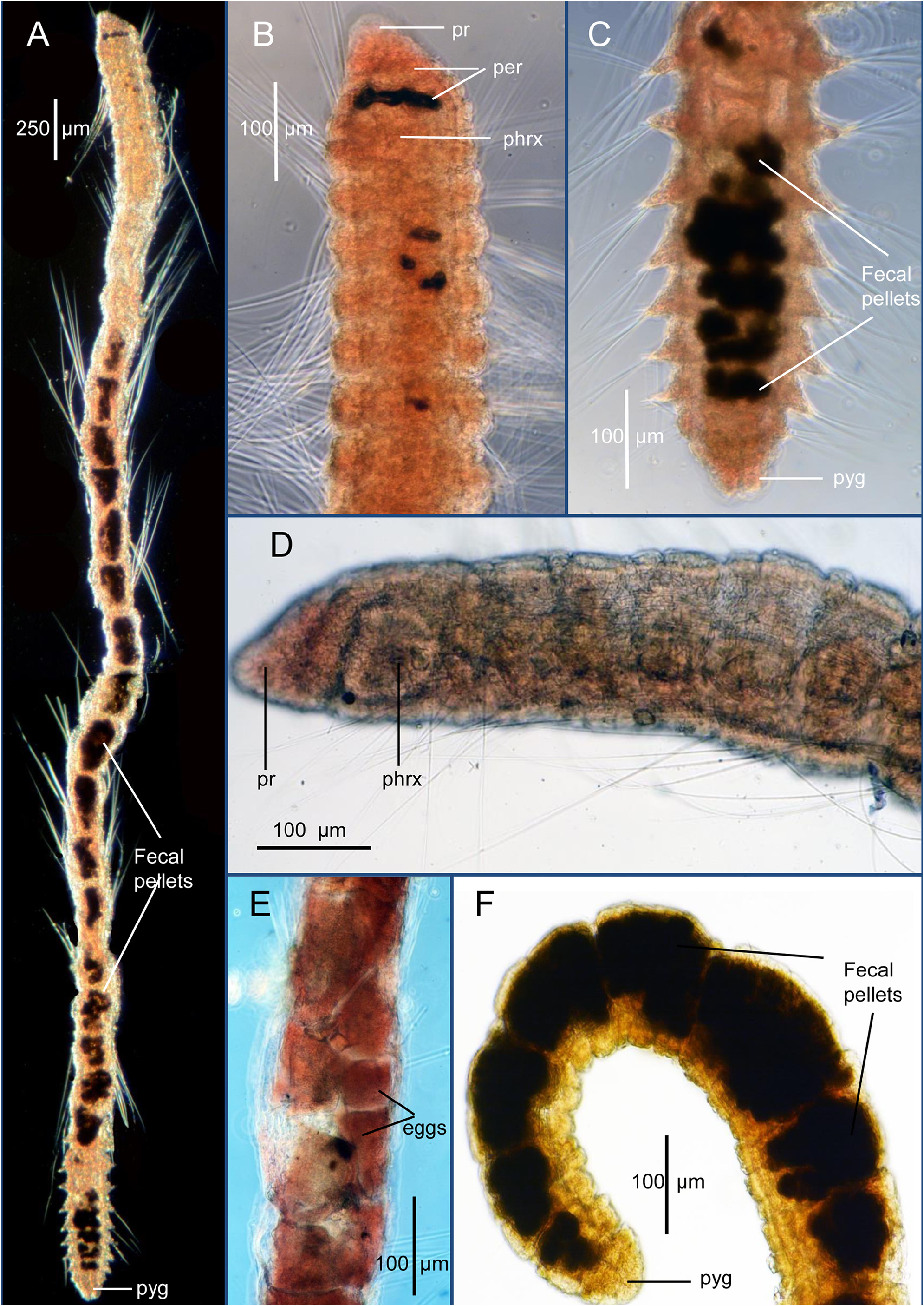
Description. A long, narrow, threadlike species ( Fig. 50A View FIGURE 50 ); holotype with 38 setigers, 4.78 mm long and 0.17 mm wide; paratype (USNM 1622444) with 43 setigers, 4.4 mm long, 0.19 mm wide. Body cylindrical in cross section throughout, with longitudinal grooves and ridges not apparent. Distinction between thoracic region and abdominal segments vague, mostly due to change in proportional size of anterior and middle segments with anterior 6–8 setigers short, about three times wider than long; middle segments longer, about 1.5 times longer than wide; segments again shorter in far posterior segments. Intersegmental areas narrow not enlarged ( Fig. 49 View FIGURE 49 A–B). Color distinctive, body light tan with dark particles concentrated into fecal pellets in gut providing characteristic dark internal patches along body in most specimens ( Figs. 49B View FIGURE 49 , 50 View FIGURE 50 A–C). Close inspection of these pellets indicate multiple smaller particles comprising larger patches enclosed in membranes.
Pre-setiger region about as long as first 2½ setigers ( Fig. 49 View FIGURE 49 A–B). Prostomium triangular, tapering to narrow rounded tip ( Figs. 49 View FIGURE 49 A–B, 50A–B, D); eyespots absent; nuchal organs not observed. Peristomium with two narrow rings, weakly separated from one another ( Fig. 49 View FIGURE 49 A–B); ventrally forming anterior and posterior lips of mouth. Mouth a narrow slit with upper lip formed of about six short lobes; lower lip with lobes indistinct ( Fig. 49B View FIGURE 49 ). Internal outline of pharynx visible dorsally ( Figs. 49A View FIGURE 49 , 50B View FIGURE 50 ), ventrally (49B) and laterally ( Fig. 50D View FIGURE 50 ); no specimens observed with everted proboscis.
Parapodia lateral along entire body, not shifted dorsally ( Fig. 49C View FIGURE 49 ); noto- and neuropodia close together, reduced to short rounded tori from which setae emerge, best seen in lateral view; in dorsal and ventral views, parapodia only projecting laterally in a few anterior setigers and newly formed posterior setigers ( Fig. 50 View FIGURE 50 A–C); postsetal lobes absent.
Noto- and neurosetae including long serrated capillaries on all segments, with 3–5 capillaries in notopodia and 2–4 capillaries in neuropodia. Long capillaries prominent along entire body ( Fig. 50A View FIGURE 50 ). Noto- and neuropodia also with 1–2 short curved acicular spines, directed towards one another, vis-à-vis ( Fig. 49C View FIGURE 49 ).
Pygidium simple, rounded, bi-lobed, surrounding anal opening; anal cirri absent ( Fig. 50A, C, F View FIGURE 50 ).
Remarks. Among the ten deep-water species of Orbiniella compared by Blake (2020), O. acsara n. sp. with smooth acicular spines and no postsetal lobes is most similar to O. aciculata Blake, 1985 from the Galápagos Rift hydrothermal vents and O. eugeneruffi Blake, 2020 from off Brunei in the South China Sea. Orbiniella acsara n. sp. differs from these species in having both peristomial rings large, of an equivalent size, and incomplete instead of one or both rings being narrow and complete. In addition, O. acsara n. sp. has no anal cirri on the pygidium instead of two or four anal cirri.
Orbiniella acsara n. sp. is also unusual in having a long, narrow, threadlike body with long capillary noto- and neurosetae. Most species of the genus have shorter, more compact bodies where the individual segments are often separated by thickened intersegmental areas producing a biannulate appearance. With O. acsara n. sp., the intersegmental areas are irregular and not formed into well-defined rings between the parapodia. In addition, the dark fecal pellets that occur in the intestine of nearly all specimens assist with recognition.
Biology. Eggs were observed in a few specimens. An ovigerous specimen (USNM 1622502) was packed with eggs along most of the body, with smaller eggs in anterior segments and larger ones in mid-body segments ( Fig. 50E View FIGURE 50 ). The largest eggs in this specimen were 83 x 107 µm and 83 x 116 µm; this would equate to an average width of ca. 95–100 µm; each visible egg was observed to have a smooth cytoplasm and a distinct germinal vesicle.
The groups of dark fecal pellets in the intestine of most specimens were observed to consist of silt particles confined by a thin membrane consistent with fecal pellet formation. Orbiniella acsara n. sp. is primarily a lower slope species (1500–3000 m) and as such occurs in sediments having a high silt + clay content ( Blake et al. 1987; Blake & Grassle 1994; Maciolek et al. 1987a–b). Owing to its small size and threadlike body, it is likely that the species resides in the upper 1–2 cm where it has access to and feeds at the sediment-water interface where newly deposited fine-grained flocculent sediments occur.
Etymology. The name acsara is derived from the acronym, ACSAR, for the Atlantic Continental Slope and Rise program (1983–1987); the new species was collected from all three survey regions.
Distribution. U.S. Atlantic continental slope: off New England, 1225–2164 m; off Delaware and New Jersey, 1503–2500 m; off North and South Carolina, 799–3019 m.

No known copyright restrictions apply. See Agosti, D., Egloff, W., 2009. Taxonomic information exchange and copyright: the Plazi approach. BMC Research Notes 2009, 2:53 for further explanation.
|
Kingdom |
|
|
Phylum |
|
|
Class |
|
|
Family |
|
|
Genus |