
Socratina keraudreniana Balle in Adansonia ser. 2, 4: 135. 1964
|
publication ID |
https://doi.org/ 10.15553/c2014v691a7 |
|
DOI |
https://doi.org/10.5281/zenodo.5641224 |
|
persistent identifier |
https://treatment.plazi.org/id/E71687B8-082A-FFF8-7C67-31612972F318 |
|
treatment provided by |
Plazi |
|
scientific name |
Socratina keraudreniana Balle in Adansonia ser. 2, 4: 135. 1964 |
| status |
|
Socratina keraudreniana Balle in Adansonia ser. 2, 4: 135. 1964 View in CoL .
Typus: MADAGASCAR. Prov.Toliara: Gorges du Fiherenana, entre Beanty et Anjamala , [22°57’S 44°19’E], 30- 300 m, I.1947, fl., Humbert 19902 (holo-: P [ P05447658] !; GoogleMaps iso-: [ P05447656 , P05447657 , P05447660 , P05447661 ]!).
Conservation status. – With an EOO of 34,514 Km², and an AOO of 108 km ² and nine subpopulations, two of which are within the protected area network (Beza Mahafaly and Tsimanampetsotsa) and one occurs in a proposed protected area which currently benefits from only temporary protection (Mikea Forest), S. keraudreniana is assigned a preliminary status of Least Concern (LC) following IUCN Red List Categories and Criteria ( IUCN, 2012).
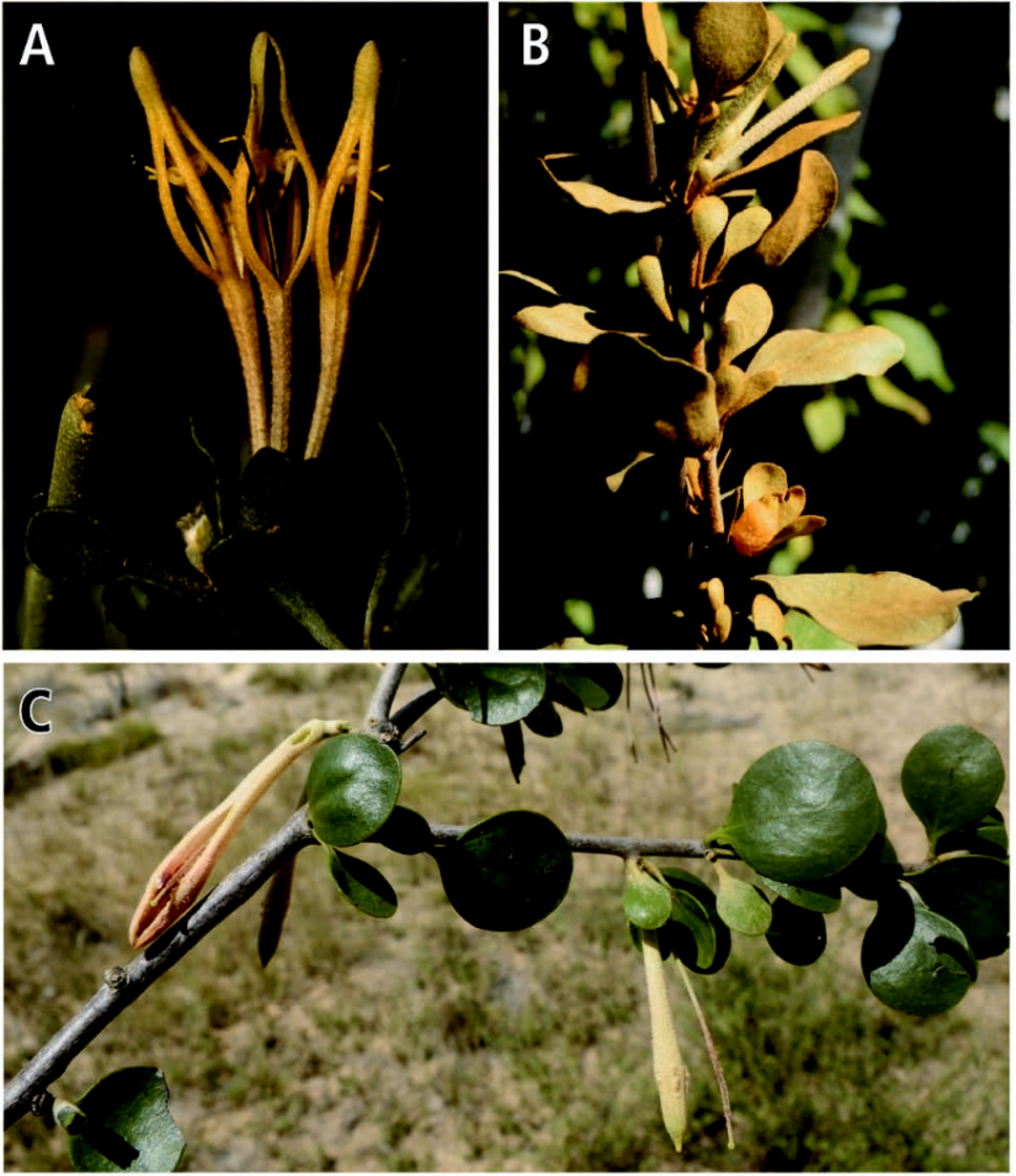
Notes. – Socratina keraudreniana is unique in the genus in having the corolla tube not splitting unilaterally at anthesis but rather divided into five lobes in the distal part only, thus the tube is much longer than the corolla lobes ( BALLE, 1964a; Fig. 2 View Fig. 2 A). The species is known from the south-western part of Madagascar in dry deciduous forests and xerophyte scrub, sometimes on limestone. Despite being a rather widely collected species, only two different hosts have been documented: Grewia sp. ( Malvaceae ) (Du Puy & al. 699) and Mimosa delicatula Baill. (Leguminosae) (Phillipson 2595) .
Additional material examined. – MADAGASCAR. Prov. Toliara: Ampanihy vers la Linta, 24°53’S 44°23’E, I.1999, fl., Allorge 2304 ( P [ P00156506 ]); GoogleMaps 30 km de Tuléar, [23°16’S 44°00’E], II.1962, fr., Bosser 15660 ( MO, P [ P 05447665, P 05447666], TAN); GoogleMaps ca. 2 km N of Itampolo on route to Lavavolo, 10 m, 24°39’S 43°58’E, 8.II.1990, fl., Du Puy & al. 630 ( K, P [ P 00075257], TAN); GoogleMaps Forest of Mikea c. 3 km N of Beroroha, 60 m, 22°52’54”S 43°33’25”E, 8.II.1990, fl., Du Puy, Labat & Comtet 699 ( K, P [ P016795 ], TAN); GoogleMaps Env. Lac Tsimanampetsotsa ( SO), 30 m, [24°07’30”S 43°47’00”E], 24.XI.1960, fl., Leandri & Saboureau 4023 ( P [ P05447651 , P 05447654]); GoogleMaps Env. Lac Tsimanampetsotsa ( SO), 30 m, [24°07’30”S 43°47’00”E], 24.XI.1960, fl., Leandri & Saboureau 4034 ( P [P05447652 ]); GoogleMaps 40 km au env. de Tuléar, 300 m, [23°10’S 44°04’E], II.1962, fl., Keraudren 1368 ( P [ P05447662 ]); GoogleMaps Fiherena, [22°57’30”S 44°19’00”E], 8.XII.1967, fl., Koechlin 10 ( P [ P05447663 ]); GoogleMaps Beza Mahafaly RS, 160 m, 23°40’S 44°36’E, 19.XI.1987, fl., Phillipson 2595 ( MO, P [ P05447653 ], TAN); GoogleMaps Betaimboraky, 120 m, 22°44’12”S 43°31’17”E, 11.XI.1998, fl., Rakotomalaza & Messmer 1816 ( G, MO, P [ P0544 7655 ]); GoogleMaps Forêt de Mikea, axe Belo-Ankilimihavotse , 0-50 m, 22°05’S 43°22’E, 30.I.2000, fl., Ranaivojaona & al. 280 ( MO, P [ P05447543 ], TAN); GoogleMaps Makay, forêt Akolitsika , 238 m, 21°40’04”S 44°59’45”E, 2 2.I.2011, buds, Razakamalala 6136 ( MO, P, TAN). GoogleMaps
| TAN |
Parc de Tsimbazaza |
No known copyright restrictions apply. See Agosti, D., Egloff, W., 2009. Taxonomic information exchange and copyright: the Plazi approach. BMC Research Notes 2009, 2:53 for further explanation.
|
Kingdom |
|
|
Phylum |
|
|
Class |
|
|
Order |
|
|
Family |
|
|
Genus |