
Balbisia verticillata Cavanilles (1804: 62
|
publication ID |
https://doi.org/ 10.11646/phytotaxa.22.1.4 |
|
persistent identifier |
https://treatment.plazi.org/id/EE5F87C3-492D-FFC6-FF29-6AA0FEBE21A8 |
|
treatment provided by |
Felipe |
|
scientific name |
Balbisia verticillata Cavanilles (1804: 62 |
| status |
|
6. Balbisia verticillata Cavanilles (1804: 62 View in CoL . tab. 46)
Lectotype (here designated): [ PERU. Depto. Lima: Prov. Canta] de 3 a 4 pies del Obragillo a Canta, estubimos en la Magdalena al regreso por Octubre en [17]93, Née s.n. ( MAD-CAV # 475405-1 - 1 !) .— Syntypes: [same collection, same locality?] ex Peruvia, Née dedit 1801 ( MAD-CAV # 475404-1 - 1 !) , Obragillo & Canta, Née ( F # 842402 !) .
= Balbisia weberbaueri R. Knuth (1912: 557) View in CoL . Lectotype (here designated): PERU. [Depto. Arequipa: Prov. Yura] zwischen Airampae [Ayrampaes] and Pampa de Acrieros [Arrieros] an der Bahn Arequipa-Puno in offener Formation von entfernt stehenden Sträuchern mit wenig ausdauernden Gräsern, zwischen 3200 und 3400 m, August 1902, Weberbauer 1408 ( B †—photograph Field Museum neg. nr. 26362!) .— Syntype: PERU. [Depto. Arequipa: Prov. Yura] am Fusse des Vulkans Misti bei Arequipa in Erdklüften, die nur zur Regenzeit von Wasser durchflossen werden, in offener Formation von Cacteen und niedrigen regengrünen Sträuchern mit wenig Graswuchs, May 1905, Weberbauer 4831 ( B †) .
= Ledocarpon chiloense Desfontaines (1818: 251 View in CoL , t. 13). Type: [ PERU. Depto. Lima:], Dombey s.n. (P).
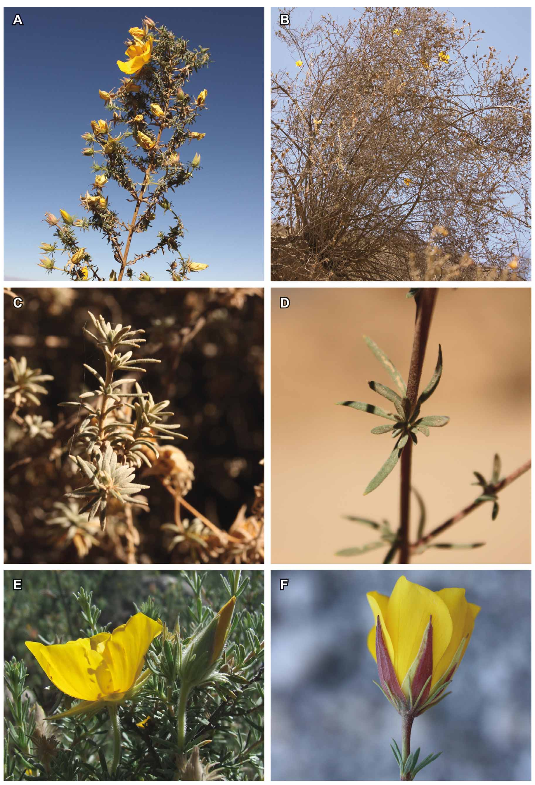
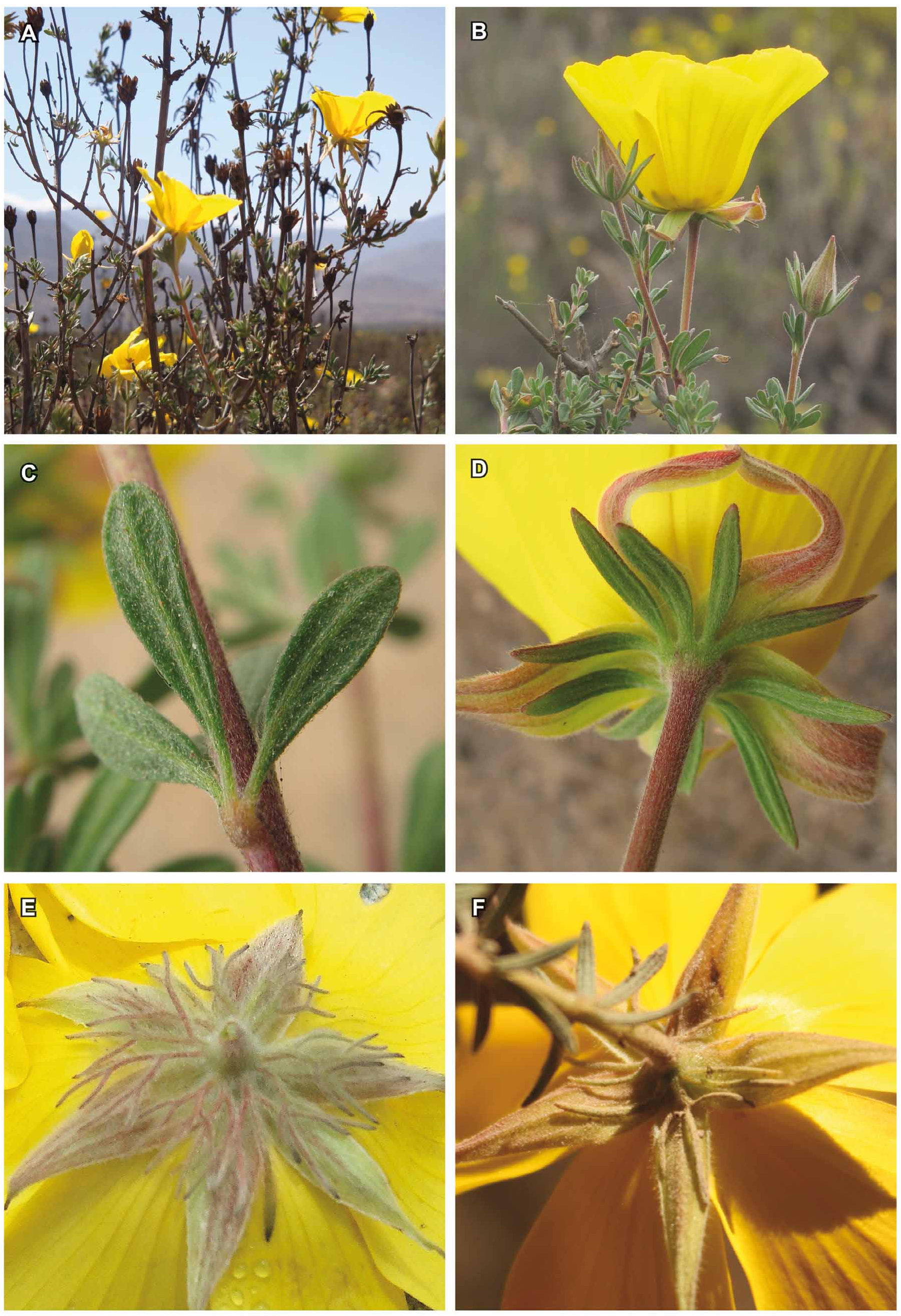
Macbride (1949) and Knuth (1912) distinguished B. verticillata View in CoL and B. weberbaueri View in CoL by distribution (Lima versus Arequipa) and petal size and pedicel length. Filament length does not appear to vary at all between populations and the former apparent distribution gap has been closed by collections from Ayacucho and Apurímac. Leaf size varies according to season and precipitation, and is not taxonomically informative (see Fig. 1 C View FIGURE 1 : dry season and Fig. 1 E View FIGURE 1 : wet season). The calyx of B. verticillata View in CoL is usually densely sericeous, green, sometimes slightly blushed with red and the epicalyx has repeatedly branched elements and is densely pubescent to villous ( Fig. 2 E View FIGURE 2 ).
There is considerable variability in leaf size and density of pubescence across the range of the species, and flowers tend to be considerably smaller during the dry season. However, morphological differences are not consistent between populations and are of no taxonomic relevance. Balbisia weberbaueri is therefore here reduced to synonymy under B. verticillata .
Ledocarpon chiloense was erroneously considered to come from Chile by Desfontaines (1818), but Don (1831) already voiced doubts and hinted at a likely origin in Peru and its identity with B. verticillata View in CoL . The table in Desfontaines (1818) leaves no doubt that this is the typical Lima-form of B. verticillata View in CoL and it has been erroneously ascribed to the flora of Chile. Dombey likely collected it near Lima, possibly in the same area as Née.
Specimens seen: PERU. Depto. Lima: Prov. Huarochiri, Canyon of Río Rimac , 6 km above Matucana, 2560–2600 m, 16 April 1964, Hutchison & Ricardi S. 4988 ( F, M) . Prov. Huarochiri, Matucana , 12 April 1922 – 3 May 1922, Macbride & Featherstone 176 ( F) . Matucana , 2389 m, August 1943, Soukup 2063 ( F) . Matucana , 2589 m, 3 July 1948, Soukup 3917 ( B) . Matucana , Weigend & Dostert 97/13 ( F, M) . Prov. Churin, Valley of Churin , 2800 m, 23 July 1954, Rauh-Hirsch P1921 ( F) . Prov. Yauyos, Road from Yauyos to Imperial , km 25.7 after Yauyos , S12° 37´18´´ W75° 58´04´´, ca. 1750 m, 8 October 2002, Weigend et al. 7312 ( BSB, USM) GoogleMaps .
Depto. Ayacucho: Prov. Puquio, km 55 on road Nazca-Puquio, 2950 m, 2 October 1997, Weigend & Förther 97/667 ( F, MSB). Puquio Valley, 2900 m, 10 March 1964, Rauh-Hirsch P412 ( F). Valley of Puquio , 3500 m, 20 March 1954, Rauh-Hirsch P2327 ( F). Coracora, 2900 m, anno 1904–1914, Weberbauer 5796 ( F) .
Depto. Apurimac: Hacienda Cotahuacho , 2900–3000 m, anno 1904–1914, Weberbauer 5856 ( F) .
Depto. Arequipa: Prov. Arequipa, Distr. Mollebaya , 21 February 2002, 2680 m, Cáceres H. & Baldárrago 3059 ( B, HUSA, USM) . 5 km ENE of Arequipa along Highway 30, km 55, S 16°24´49.2´´, W 71° 27´07.2´´, 2880 m, 23 February 1994, Anderson et al. 7923 ( F) GoogleMaps . Yura , 2500 m, 18 March 1951, Rauh-Hirsch P572 ( F) . E of Yura , 2700 m, 10 May 1977, Solomon 2806 ( F) . San Antonio, 3–4 km from Yarabamba , 2545 m, S 16° 34.411´, W 071° 28.456´, Dostert & Cáceres H. 1020 (2 x B) GoogleMaps . Volcán Chachani, W-facing Quebrada , 28 March 1990, Ozasky 70 ( F) . Yura , 8 August 1939, 2800 m, Schmidt s.n. ( F) . Volcán de Arequipa, Weddell 4370 (fragment F) . Prov. Arequipa, Quebrada de San Lazaro , 3150 m, 11 March 1939, Munz 15508 ( F) . Chiguata , 3350 m, 3 August 1959, Infantes Vera 6310 ( M) . Slopes of Volcán Misti, Guillen-Cardenas & Calienes-Rodriguez 12 ( F) . Arequipa, above Arequipa, 2600–2700 m, 7–14 April 1925, Pennell 13188 ( F) . Arequipa, 4 August 1863, Isern 2275 ( F) . Road Arequipa – Pocsi, km 53 on road to Puquina , S 16° 31´12´´, W 071° 25´52´´, 3080 m, 21 May 1903, Weigend et al. 7752 ( B, F, M) GoogleMaps . San Antonio de Yarabamba , along road between Yarabamba and Chapi, S 16° 35' 31.7'' W 071° 24' 44.0'', 3188 m, Weigend et al. 9204 ( B, HUSA, M, USM) GoogleMaps . Arequipa, Ayrampal , August 1939, Soukup 1294 ( F) . Prov. La Unión, Distr. Cotahuasi, Saucay , S 15° 12´45´´, W 072° 53´37,3´´, 2630 m, Cáceres H. 5395 ( B, HUSA, HUT, USM) GoogleMaps . Prov. Arequipa, between Arequipa and Yura on road north, W 071° 38.747´, S 16° 10.332´, 3155 m, 11 April 2004, Weigend & Schwarzer 7817 ( B, M) GoogleMaps . Prov. Arequipa, Km 53 on road from Arequipa to Puquina (Moquegua), between Arequipa and Pocsi (before highest point in road), S 16° 31’ 12”, W 071° 25’ 52”, 3080 m, Weigend et al. 2000/550 ( B, HUSA, NY, M) GoogleMaps .
Depto. Moquegua: Prov. General Sánchez Cerro, Distr. Matalaque, S 16 28 09.46´´, W 70 49 07.02´´, 2700 m, 8 February 2009, Cáceres H GoogleMaps . & Arce 7180 ( B, HUT). Prov. General Sánchez Cerro, Distr. Matalaque, S 16° 28´09.44´´, W 70° 49´07.5´´, 2613 m, 8 February 2009, Cáceres H GoogleMaps . & Arce 7189 ( B, F, HUT), Puquina, just after Puquina on road to Arequipa, S 16° 36´53.5´´, W 071° 12´03.1´´, 3143 m, 21 July 2010, Weigend & Baldárrago 9367 ( B, HUSA, M, USM) GoogleMaps .
Without precise locality: Dombey s.n. (fragment F).
BOLIVIA. Depto. Chuquisaca: Prov. Zudañez, Icla to Candelaria , S 19° 13.90´, W 064° 47.35´, 2800 m, 14 December 2002, Wood & Huaylla 18647 A GoogleMaps ( LPB) GoogleMaps .
Depto. Tarija: Prov. Eustaquio Méndez, Iscayachi, 28 km towards Paicho, 3250 m, 11 November 1993, Beck et al. 22108 ( LPB, M). Prov. Eustaquio Méndez, Localidad San Lorencito, 3500 m, 26 August 1999, Acosta 1164 ( LPB) .
| B |
Botanischer Garten und Botanisches Museum Berlin-Dahlem, Zentraleinrichtung der Freien Universitaet |
| S |
Department of Botany, Swedish Museum of Natural History |
| F |
Field Museum of Natural History, Botany Department |
| M |
Botanische Staatssammlung München |
| BSB |
Freie Universität Berlin |
| USM |
Universiti Sains Malaysia |
| MSB |
Museum of Southwestern Biology |
| H |
University of Helsinki |
| HUSA |
Universidad Nacional de San Agustín de Arequipa |
| E |
Royal Botanic Garden Edinburgh |
| HUT |
HUT Culture Collection |
| NY |
William and Lynda Steere Herbarium of the New York Botanical Garden |
| A |
Harvard University - Arnold Arboretum |
| LPB |
Herbario Nacional de Bolivia, Universidad Mayor de San Andrés |
No known copyright restrictions apply. See Agosti, D., Egloff, W., 2009. Taxonomic information exchange and copyright: the Plazi approach. BMC Research Notes 2009, 2:53 for further explanation.
|
Kingdom |
|
|
Phylum |
|
|
Class |
|
|
Order |
|
|
Family |
|
|
Genus |
Balbisia verticillata Cavanilles (1804: 62
| Weigend, Maximilian 2011 |
Balbisia weberbaueri R. Knuth (1912: 557)
| Knuth, R. 1912: ) |
Ledocarpon chiloense
| Desfontaines, M. 1818: 251 |