
Agonocryptus varus ( Brullé, 1846 )
|
publication ID |
https://doi.org/ 10.11646/zootaxa.5178.6.3 |
|
publication LSID |
lsid:zoobank.org:pub:19F4AA27-40EA-4434-B7A9-BB99EBE39CE0 |
|
DOI |
https://doi.org/10.5281/zenodo.7044133 |
|
persistent identifier |
https://treatment.plazi.org/id/41598272-FF9D-FF86-AF6F-FF02FAF0FDD6 |
|
treatment provided by |
Plazi |
|
scientific name |
Agonocryptus varus ( Brullé, 1846 ) |
| status |
|
Agonocryptus varus ( Brullé, 1846) View in CoL
( Figs 15A–P View FIGURE 15 , 20H View FIGURE 20 , 21I View FIGURE 21 )
Mesostenus varus Brullé, 1846 . Original description.
Agonocryptus varus: Townes, 1966 . Catalog.
Agonocryptus varus: Gupta, 1982 . Subspecies assignment, description, male and female, keyed, map.
Agonocryptus varus: Yu et al., 2016 . Catalog.
Variation. Clypeal groove black ( Figs 15F–J View FIGURE 15 ) (vs. concolorous with clypeus); pronotal collar stripe often (27%) entirely yellow or narrowed, but not interrupted ( Figs 15A–C View FIGURE 15 ) (vs. yellow stripe interrupted centrally); hind coxa dorsally often (33%) with a narrow yellow streak ( Figs 15A, D, K View FIGURE 15 ) (vs. absent); hind coxa dorso-basally with a small black spot ( Fig. 15K View FIGURE 15 ) (vs. absent); fore wing sometimes (16%) hyaline with fuscous stripes both medially and apically ( Fig. 15C View FIGURE 15 ) (vs. without stripes); T2 basally with yellow band (vs. absent), pre-apically with two dark brown spots ( Figs 15L–O View FIGURE 15 ) (vs. absent), apex centrally with transversal yellow mark ( Figs 15M–O View FIGURE 15 ) (vs. absent).
Three specimens (E. E. Jataí and Barretos, both in São Paulo State, southeastern Brazil) have hind coxa dorso basally with a brown mark ( Fig. 15B View FIGURE 15 ) (vs. absent).
One specimen from Simla ( Trinidad & Tobago) has T2–6 apical margin centrally with whitish marks ( Fig. 15P View FIGURE 15 ) (vs. absent).
Comments. A pronotal collar with an interrupted yellow stripe is cited by Gupta (1982) as diagnostic for the subspecies, but a complete stripe was observed for about 1/3 of the specimens studied for the present work, namely those from Altamira (Pará State, northern Brazil), Estação Ecológica Jataí (Luis Antônio), Sales, Pindorama, and Barretos (São Paulo State, southeastern Brazil), and Department Santa Cruz ( Bolivia).
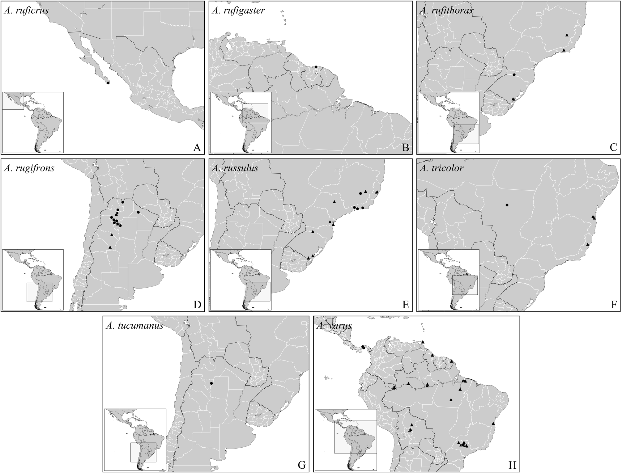
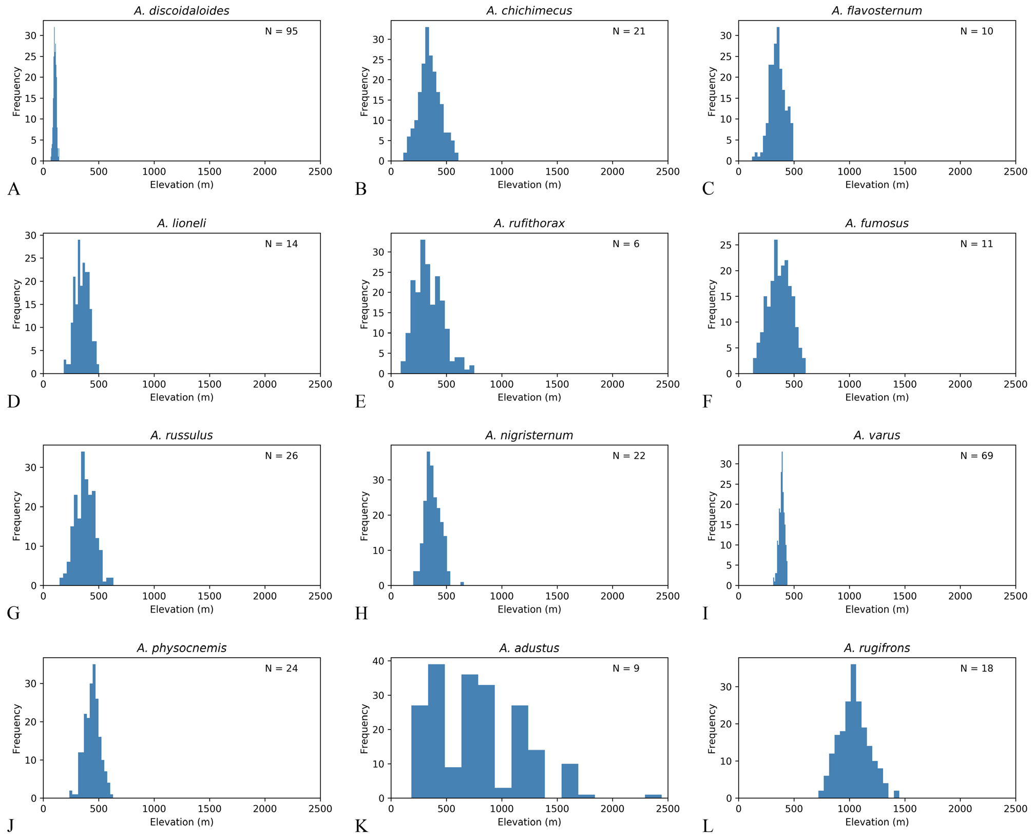
Distribution. Bolivia NR, Brazil NR (Amazonas, Bahia, Pará, São Paulo), Colombia NR, French Guyana NR, Panama, and Trinidad & Tobago NR (Arima Valley) ( Fig. 20H View FIGURE 20 ). Bootstrap analysis suggests that this species has a strong preference for elevations between 400–500 m ( Fig. 20I View FIGURE 20 ), a very strict range if compared with other Agonocryptus spp. ( Fig. 20 View FIGURE 20 ).
Material examined. Total of 84♀. BOLIVIA, 1♀, 2?, Cochabamba, Vila Tunari,?, 263 m, 16°54’55”S, 65°22’06”W, 2001-11-08, H.Heider, Malaise, 2?, CNCI GoogleMaps • 3ib, Beni Department,?, Rio Mamore at mouth of Rio Ibare, ib, 161 m, 15°05’17.86”S, 64°42’18.78”W, 1965-08-15 /16, J.K.Bouseman,?, 2ib, AMNH GoogleMaps • 10ib, 1965-08- 18 /20, 5ib GoogleMaps • 3ib, Santa Cruz Department, ib, Rio Mamore 2 Km N. mouth of Rio Chapare , ib, 209 m, 16°35’50.58”S, 65°01’41.28”W, 1965-07-30, 5ib GoogleMaps • BRAZIL, 2ib,?, ib, Est. Dir.Aer. R. Humb. M. T., ib, 3?, 1975-09-26, I.P.[Alves?] & J.B.Moares, 2ib, 132, INPA GoogleMaps • 2ib, Amazonas, 2ib, Mamiraua, ib, 52 m, 2°13’54.92”S, 65°43’08.94”W, 1994- 06-11 /14, I.S.Gorayeb & O.T.Silveira, Malaise suspensa 20 m, ib,?, MPEG GoogleMaps • 4ib, Manaus, Estrada AM-010 Km 246, ib, 46 m, 2°58’09.62”S, 60°00’53.78”W, 1979-07-13, J.R.Arias,?, 2ib, INPA GoogleMaps • 5ib, Estrada AM-010 Km 31 Embrapa, ib, 98 m, 2°53’39.18”S, 59°58’21.29”W, 1991-12-26, L.P.Albuquerque & J.Binda, Shannon Trap with Fruit bait, 3ib GoogleMaps • 5ib, Fazenda Esteio ZF-03 Km 23 Res. 1113, ib, 125 m, 2°26’02”S, 59°51’15”W, 1986-05- 29, B.Klein, Malaise, ib, 68179, ib GoogleMaps • 5ib, Reserva Ducke, ib, 100 m, 2°57’48.15”S, 59°55’22.26”W, 1969-08-14, A.Faustine,?, ib, 2910, ib GoogleMaps • 5ib, Reserva Florestal Adolfo Ducke, 4ib, 2005-09/10-28/08, A.P.Aguiar et al., Malaise, UFES42002 View Materials , LAPIS4599, UFES GoogleMaps • 2ib, Bahia, ib, Coaraci, Fazenda São José, ib, 193 m, 14°38’29”S, 39°32’12”W, 2002-11-26, J.Cardoso & J.Maia, ib, UFES45587 View Materials ,?, CEPLAC GoogleMaps • 2ib, Pará , ib, Altamira , Itapuarna , Xingu river , 204 m, 7°16’08.31”S, 52°35’04.91”W, 2008-08-15 /23,?, ib,?, ib, UFES GoogleMaps • 5ib, Torrão , 4ib, 2008-08-19 /23, 5ib GoogleMaps • 4ib, Benevides , Fazenda Morelandia ,?, 26 m, 1°21’41.43”S, 48°14’37.46”W, 1988-07-07, A.N.Pena,?, 2ib, MPEG GoogleMaps • 10ib, 1991-09-18, W.França, 4ib GoogleMaps • 4ib, Bujaru ,?, ib, 12 m, 1°30’58.58”S, 48°02’44.49”W, 1977-06-29, P.Waldir & L.Braack, 4ib GoogleMaps • 4ib, P. de Pedras, 2ib, 7 m, 1°23’31.94”S, 48°52’14.42”W, 1979-03-03, P.Tadeu, 4ib GoogleMaps • 4ib, Tucurui , Canoal , Tocantins river, 80 m, 4°00’51.30”S, 49°45’37.80”W, 1984-03-27, M.F.Torres, 4ib GoogleMaps • 2ib, São Paulo, ib, Barretos , 2?, 550 m, 20°34’22.62”S, 48°34’01.66”W, 2008-08-20, N.W.Perioto et al., Malaise , 2ib, UFES GoogleMaps • 10ib, 2009-03-21, 2?, 3ib GoogleMaps • 10ib, 2009-05-08, 5ib • 10ib, 2009-07-13, 5ib GoogleMaps • 4ib, Descalvado , Fazenda Itaúna , ib, 655 m, 21°54’05”S, 47°37’26”W, 2005-10-20, N.W.Perioto et al., Malaise , 2ib, IBRP GoogleMaps • 16ib • 10ib, 2005-12-15, 5ib • 10ib, 2006-10-19, 5ib GoogleMaps • 4ib, Luiz Antônio , Estação Ecológica Jataí , ib, 539 m, 21°35’16.9”S, 47°47’44.2”W, 2007-06-21, 5ib • 7ib, 532 m, 2ib, 2007-08-16, 5ib GoogleMaps • ib, 2♀, 5ib, 539 m, 2ib, 2007-09-13, 5ib GoogleMaps • ib, 1♀, 5ib, 532 m, 21°37’26.1”S, 47°48’24.5”W, 6ib GoogleMaps • 10ib, 2007-09-27, 5ib GoogleMaps • ib, 2♀, 14ib • 7ib, 589 m, 21°36’10.2”S, 47°46’47.6”W, 2007-10- 11, 5ib GoogleMaps • ib, 1♀, 5ib, 532 m, 21°37’26.1”S, 47°48’24.5”W, 2007-11-07, 5ib GoogleMaps • ib, 2♀, 5ib, 539 m, 21°35’16.9”S, 47°47’44.2”W, 2008-04-09, 5ib GoogleMaps • ib, 1♀, 8ib, 2008-04-23, 5ib GoogleMaps • 7ib, 532 m, 21°37’26.1”S, 47°48’24.5”W, 2008-07- 17, ib, YPT, 3ib GoogleMaps • 10ib, 2008-09-03, ib, Malaise , 3ib GoogleMaps • 10ib, 2008-09-17, 5ib GoogleMaps • 16ib • 10ib, 2008-10-01, 5ib GoogleMaps • 10ib, 2008-10-15, 5ib GoogleMaps • 8ib, 21°37’26.4”S, 47°48’24.2”W, 2008-12-10, 5ib GoogleMaps • 8ib, 21°37’26.1”S, 47°48’24.5”W, 2009-04- 15, 5ib GoogleMaps • 7ib, 539 m, 21°35’16.9”S, 47°47’44.2”W, 2009-07-22, 5ib GoogleMaps • ib, 2♀, 8ib, 2009-08-19, 5ib • ib, 3♀, 5ib, 589 m, 21°36’10.2”S, 47°46’47.6”W, 6ib GoogleMaps • 10ib, 2009-09-16, 5ib GoogleMaps • ib, 1♀, 5ib, 532 m, 21°37’26.1”S, 47°48’24.5”W, 6ib GoogleMaps • 8ib, 21°37’26.4”S, 47°48’24.2”W, 6ib GoogleMaps • ib, 2♀, 6ib, 21°35’16.9”S, 47°47’44.2”W, 2009-09-30, 5ib GoogleMaps • 7ib, 539 m, 8ib GoogleMaps • ib, 1♀, 8ib, 2009-10-15, 5ib • ib, 2♀, 14ib GoogleMaps • ib, 1♀, 5ib, 589 m, 21°36’10.2”S, 47°46’47.6”W, 6ib GoogleMaps • 7ib, 532 m, 21°37’26.1”S, 47°48’24.5”W, 2009-10-29, 5ib GoogleMaps • 4ib, Magda ,?, ib, 507 m, 20°38’41.53”S, 50°13’30.07”W, 2008- 11-26, 2?, 2ib, UFES GoogleMaps • ib, 2♀, 2ib, Matão , 2ib, 550 m, 21°36’03.79”S, 48°21’39.37”W, 2008-12-02, 5ib GoogleMaps • ib, 1♀, 2ib, Sales , 2ib, 413 m, 21°20’47.48”S, 49°29’57.86”W, 2007-08-24, 5ib GoogleMaps • 16ib • ib, 2♀, São Paulo?, ib, Pindorama , 2ib, 510 m, 21°11’10”S, 48°54’23”W, 2009-08-19, ib, Malaise , 3ib GoogleMaps • COLOMBIA, 1♀, Meta, San Martín ,?, PNN Amacayacu , ib, 150 m, 3°23’S, 70°6’W, 2001-10-2 /15, D.Chota, 2ib, M.2246, IAVH GoogleMaps • FRENCH GUYANA, ib, 2?, Patawa Kaw Mts. ,?, ib, 309 m, 4°33.562’0”N, 52°12.425’0”W, 2007-08, J.Cerda, 2ib,?, CNCI GoogleMaps • ib, 2♀, 8ib, 2007-09, 5ib GoogleMaps • ib, 1♀, 2ib, Roura , Montagne des Chevaux , ib, 65 m, 4°43’21.19”N, 52°24’45.22”W, 2009-05- 01 /31, S. E.A. G.,?, ib, LAPIS6502, UFES GoogleMaps • GUYANA, 3ib,?, Tropical Research Station , ib, 37 m, 6°34’28.87”N, 58°19’21.33”W,?, N.Y. Zoology Society, 2ib, 20417, AMNH GoogleMaps • TRINIDAD & TOBAGO, 3ib, Curepe ,?, ib, 13 m, 10°38’12.47”N, 61°24’20.72”W, 1977-12-01 /10,?, L. M. Trap, ib,?, CNCI GoogleMaps • 2ib, Arima Valley , ib, Simla , William Beebe Research Station , ib, 250 m, 10°41’33”N, 61°17’22”W, 1977-11/12-25/03, Mason , Malaise , 3ib GoogleMaps .

| CNCI |
Canadian National Collection Insects |
| AMNH |
American Museum of Natural History |
| MPEG |
Museu Paraense Emilio Goeldi |
| UFES |
Universidade Federal do Espirito Santo |
| IBRP |
Institute for Breeding Research, Tokyo University of Agriculture |
| IAVH |
Instituto de Ivestigacion de los Recursos Biologicos Alexander von Humboldt |
No known copyright restrictions apply. See Agosti, D., Egloff, W., 2009. Taxonomic information exchange and copyright: the Plazi approach. BMC Research Notes 2009, 2:53 for further explanation.
|
Kingdom |
|
|
Phylum |
|
|
Class |
|
|
Order |
|
|
Family |
|
|
Genus |