
Lamourouxia pringlei Robinson & Greenman. Gard. & Forest
|
publication ID |
https://doi.org/ 10.11646/phytotaxa.582.1.1 |
|
DOI |
https://doi.org/10.5281/zenodo.7618503 |
|
persistent identifier |
https://treatment.plazi.org/id/F613E609-4954-FFB4-78CF-D2F7FAB69C51 |
|
treatment provided by |
Plazi |
|
scientific name |
Lamourouxia pringlei Robinson & Greenman. Gard. & Forest |
| status |
|
19. Lamourouxia pringlei Robinson & Greenman. Gard. & Forest View in CoL 8(385): 273, 275. 1895.
Lectotype designated here:— MEXICO. Oaxaca: San Felipe, found growing on the rocky and wooded summit ridges of San Felipe, 1894, C.G. Pringle 4927 (Lectotype: MO-155211 !; isolectotypes:AC00320443!, BKL00004274!, BR0000008428080!, CM2010, E00394558!, ENCB0003598!, F0072506F!, G00356751!, G00356752!, GH00078583!, GOET011028! HBG511949!, JE00019793!, K000533731!, MEXU00031624!, MEXU00031626!, MSC, NDG50289!, NY00090608!, P02995395!, P02995396!, PH00016833!, RSA 0006028!, S-G-3537!, US00125707!, US 00125708!, VT UVMVT026730!, WIS v0256296WIS!). Not Lamourouxia pringlei Gandoyer. Bull. Soc. Bot. France 66(5–6): 217. 1919.
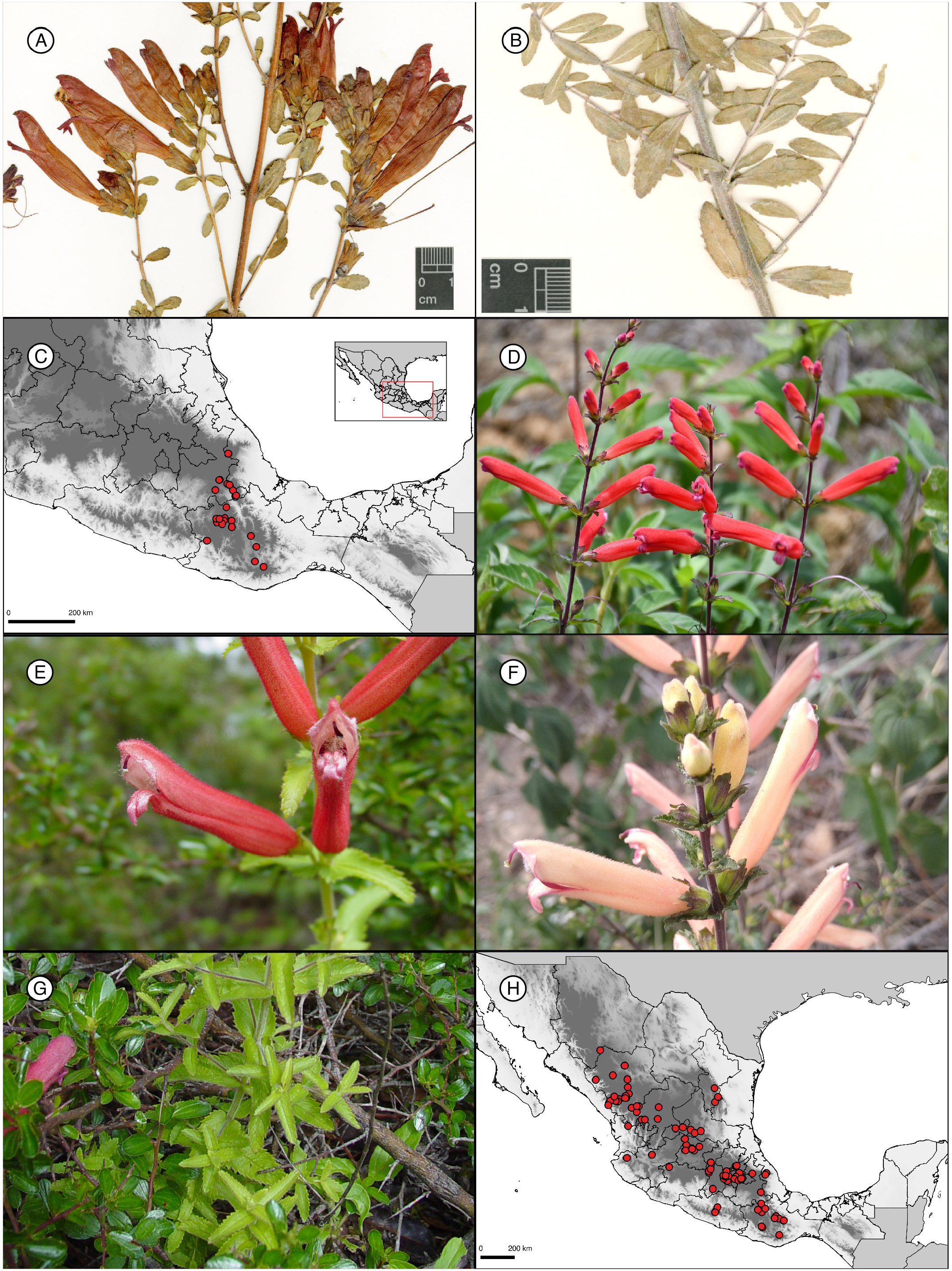
Figure 13 A–C View FIGURE 13 .
Shrubs or sub-shrubs 40–200 cm tall, stems branched along the plant, erect, woody, glandular-puberulous. Leaves sessile, lanceolate to elliptic, rarely narrowly spatulate, 5–19 × 2–5 mm, margin entire, apex acute or obtuse, base cuneate to rounded; membranous, glandular-pubescent. Inflorescence a raceme, erect, pedicels thin, 2–5 mm long. Bracts equal along inflorescence, sessile, lanceolate to elliptic, 4–9 × 3–4 mm, margin entire, apex obtuse, base cuneate. Calyx campanulate without dots on the surface, 7–11 × 5–7 mm, lobes lanceolate to triangular, 1.8–6.5 × 2–4 mm, margin entire, apex acute to obtuse, rarely acuminate, glandular-pubescent. Corolla funnelform, 29–37 × 6–10 mm, upper lip 7–10 × 5–6 mm, lower lip 4–8 × 3–5 mm, lobes 2.2–3 mm × 1.4–2.2 mm; red, glandular-pubescent. Stamens exserted 4, 14–25 mm long, anthers 2.4–3.9 mm. Style 23–34 × 0.4–0.8 mm, stigma bilobed, 0.7 × 1 mm. Capsule ovoid, 11–14 × 6–8 mm, glabrous. Seeds not seen.
Etymology: —The name of this species honors C.G. Pringle, collector of the type specimen.
Distribution and Ecology: —This species is endemic from the states of Oaxaca, Puebla, and Veracruz ( Fig. 13C View FIGURE 13 ). Collections are from xerophytic scrubs ( Acacia , Brahea dulcis (Kunth in Humboldt, Bonpland, and Kunth 1815 [1816]: 300) Martius (1838: 244), oak forests ( Quercus acutifolia Née (1801: 267) , Q. rugosa with Arbutus , Juniperus flaccida , and Rhus ), pine forests, Pseudotsuga menziesii forests, and pine-oak forests, at elevations of 2000–3048 m.
Phenology: —Flowering and fruiting occur from August to March.
Discussion: —Please see L. paneroi to know more about the similarity with L. pringlei .
Nomenclatural notes: —The type collection of Lamourouxia pringlei has numerous duplicates in several herbariums widely distributed. It was selected as lectotype the specimen MO-155211! because it exhibits the branching pattern with open inflorescences and mature flowers. Other specimens consist mostly of two stems not branched.
Examined specimens: — MEXICO. Oaxaca: Chilapa de Díaz, 1 km de San Marcos Monte de León, a 4 km de Chilapa de Díaz sobre la carretera de terracería a Chilapa de Díaz , 2150 m, 24 December 2002, Calzada 23686 ( MEXU!). Cristóbal Suchixtlahuaca , 7 km al SO-S de Suchixtlahuaca, por la terracería rumbo a Santiago Tenejupan, 2250 m, 20 November 1985, Salinas & Dorado F-3036 ( MEXU!). Nochixtlán, Mixteca Alta, 600 m antes de la desviación a Jaltepec , antes de Nochixtlán, 2330 m, 06 February 1993, Cházaro et al. 7064 ( MEXU!, XAL!); Cerros de Nochixtlán , 2250 m, 17 October 1921, Conzatti 4298 ( MEXU); 12 km al NE de Nochixtlán camino a Huautla y 2 km al S de Fortín Alto , 2310 m, 23 January 1986, García-Mendoza et al. 2079 ( XAL!). Rojas de Cuauhtémoc , a unos 20 km al NNE de Tlacolula, km 575 de la carr. Mex-Oax., 3000 m, 30 January 1966, Delgadillo 186 ( MEXU!, US!). San Bartolomé Quialana, Alrededores del mirador en la parte más alta del cerro Yuubldan a 4 km de la población, 2850 m, 23 November 2013, Aragón-Parada 938, 939 ( MEXU!). San Juan Mixtepec , near town, 2100 m, 19 December 1996, Hunn OAX-641 ( MEXU!, MO). San Juan Teposcolula, Cerro Yucudaá , torre de microondas, 2700 m, 19 October 1990, A. García-Mendoza & Reyes-Santiago 4963 ( MEXU!); 1 km al N de Teposcolula , 2390 m, 22 February 1982, García-Mendoza 886 ( MEXU!); Yucudá, por las torres de microondas, a 1.5 km al NO de la desviación a Teposcolula , 2700 m, 19 October 1990, Reyes-Santiago & García-Mendoza 2464 ( MEXU!). San Miguel Chicahua , 8.6 km al NO de Amatlán camino a Apoala, 2438 m, 10 November 2001, García-Mendoza & Solano 7331 ( MEXU!). San Pedro y San Pablo Teposcolula , Ladera N del cerro de Pueblo Viejo, 2350 m, 05 November 2005, García-Mendoza et al. 8168 ( MEXU!). Santa Catarina Ixtepeji, Paraje “Peña Prieta”, 15 km al norte de la Ciudad de Oaxaca y a 3 km al noroeste del poblado “El Estudiante”, 2700 m, 23 August 1997, Acevedo 26 ( MEXU!). Tepelmeme Villa de Morelos, Cañada Otates , brecha a Hijadedoaria, 2092 m, 02 March 2001, Tenorio 19958 ( MEXU!). Villa de Tamazulápam del Progreso , 4.5 km al sureste de Tamazulápan, 22 October 1977, González-Medrano & Hiriart 10611 ( MEXU!); 7 km al SW de Tamazulápan sobre la carretera a Chilapa, 2350 m, 12 December 1981, Rzedowski 37688 ( MEXU!). Villa Díaz Ordaz , a 16 km al NE de Díaz Ordaz , 2780 m, 08 December 1982, Cedillo 1932 ( MEXU!); about 11 miles north of Tlacolula above Valley of Diaz Ordaz , 3000 m, 30 January 1966, Ernst & Delgadillo 2384 ( MEXU!, P!, US!). Cerro cercano al entronque de la carretera Yucudaá-Pinotepa , 2270 m, 02 november 1981, García-Mendoza 808 ( MEXU!, MO). Puebla: Ajalpan , 1 km al S de San Luis del Pino, 02 December 1991, Salinas & Martínez 6407 ( MEXU!). Caltepec , al SE, Cerro El Castillo, Tenorio 15379 ( MEXU). Chapulco, 2 km antes de llegar a Nicolás Bravo, carretera Azumbilla-Lagunas de San Bernardino , 2300 m, 28 September 1989, Cházaro et al. 6095 ( XAL!). Coxcatlán, Carretera de Coyomeapan a Zoquitlán , ranchería Pala , 2446 m, 06 February 2015, Salazar et al. 9421 ( MEXU!); 4 km al E de Pala, brecha a Zoquitlán , 2490 m, 28 September 1984, Tenorio et al. 7467 ( MEXU!). Nicolás Bravo, Volcán Otzelotzi , a un lado de las lagunas de San Bernardino, 2750 m, 20 October 1996, Cházaro et al. 7673 ( MEXU!). Palmar de Bravo, Cerro Tepoxtla de San Martín Esperilla , 2700 m, 31 October 1991, Tenorio et al. 17965 ( MEXU!). Tepanco de López, Teontepec , 1 km al W de Nopala, brecha a Atexcal, 2100 m, 27 September 1984, Tenorio et al. 7454 ( MEXU!). Tlacotepec de Benito Juárez, San Marcos Tlacoyalco, Carretera Cuacnopalan-Esperilla , aproximadamente 2 km al N de Esperilla, 2000 m, 07 September 1995, Panero et al. 5801 ( MEXU!). Veracruz: Perote , cerro de Tenextepec, 2500 m, 27 October 1997, Castillo-Campos et al. 16499, 16513 ( XAL!); 19 February 1998, Castillo-Campos et al. 16591 ( XAL!); Hacienda de San Agustín , al SE, 2560 m, 04 November 1998, Castillo-Campos et al. 18725 ( XAL!).
| MEXU |
Universidad Nacional Autónoma de México |
| XAL |
Instituto de Ecología, A.C. |
| MO |
Missouri Botanical Garden |
No known copyright restrictions apply. See Agosti, D., Egloff, W., 2009. Taxonomic information exchange and copyright: the Plazi approach. BMC Research Notes 2009, 2:53 for further explanation.
|
Kingdom |
|
|
Phylum |
|
|
Class |
|
|
Order |
|
|
Family |
|
|
Genus |