
Burmeistera sylvicola Zahlbr., Repert., 2023
|
publication ID |
https://doi.org/10.11646/phytotaxa.615.1.1 |
|
DOI |
https://doi.org/10.5281/zenodo.8400840 |
|
persistent identifier |
https://treatment.plazi.org/id/800C87C6-603A-FFCB-C6C7-CA2EFA209EEB |
|
treatment provided by |
Plazi |
|
scientific name |
Burmeistera sylvicola Zahlbr., Repert. |
| status |
sp. nov. |
51. Burmeistera sylvicola Zahlbr., Repert. View in CoL Spec. Nov. Regni Veg. 13: 532. 1915.
Type :— COLOMBIA. Valle del Cauca: “In sylvis densis humidisque in Cordilleranibus Occidentalibus in jugo Cali”, 2000 m, Aug 1883 (fl, fr), F. Lehmann 2990 ( holotype: W, not seen; isotype: G! [ G00236672 ]). Figs. 25 View FIGURE 25 , 26 View FIGURE 26 .
Upright to procumbent herbs up to 1.5 m tall. Stem puberulous when young, later glabrescent. Petiole 2.0– 3.5 cm long, glabrescent to puberulous; blade ovate, oblong or elliptic, rarely obovate, 12–22 × 4–12 cm, glabrous above, puberulous along the veins beneath, base cuneate, apex acute to acuminate, margin subentire to repandous to irregularly serrate especially along the 2/3 – ¾ distal portions, then with obtuse teeth of 4–6 × 5–8 mm, the long ones spaced ca. 1 cm apart and sometimes interspersed with short teeth, hydathodes extramarginal, 14 to 18 per side, secondary veins 12 to 16 per side, intramarginal vein present, often discontinuous. Peduncle 2.5–5.0 cm (to 6.5 cm in fruit), glabrous or very slightly puberulous at its proximal portion, ebracteolate. Hypanthium subglobose to urceolate, 5–7 × 4–6 mm, glabrescent. Calyx lobes narrowly ovate, (4–)6–10 × 1.5–2.0 mm, patent to reflexed, glabrescent to puberulous, basally spaced by sinuses ca. 1 mm wide, margin with 2 or 3 small teeth per side, apex acute. Corolla green to yellow, glabrescent to sparsely puberulous; tube 1.5–2.4 cm long, 2.5–3.0 mm diameter at its mid-level, slightly inflated proximally and distally; lobes narrowly ovate, falcate, apex obtuse to acuminate; dorsal lobes 10–14 × 2.5–3.8 mm, lateral lobes 7–9 × 2–4 mm, ventral lobe 4.8–5.2 × 2–3 mm. Synandrium 2.1–2.7 cm long, exserted up to 11 mm; filament tube 1.6–2.0 cm long, glabrescent to puberulous; anther tube 5–7 mm long, glabrescent to sparsely puberulous, ventral anthers barbate. Berries oblate to globose, 8–10 × 10–15 mm, not inflated, glabrous, white, green or rarely purple.
Phenology: — Burmeistera sylvicola sets flowers and fruits from January to October, and in December.
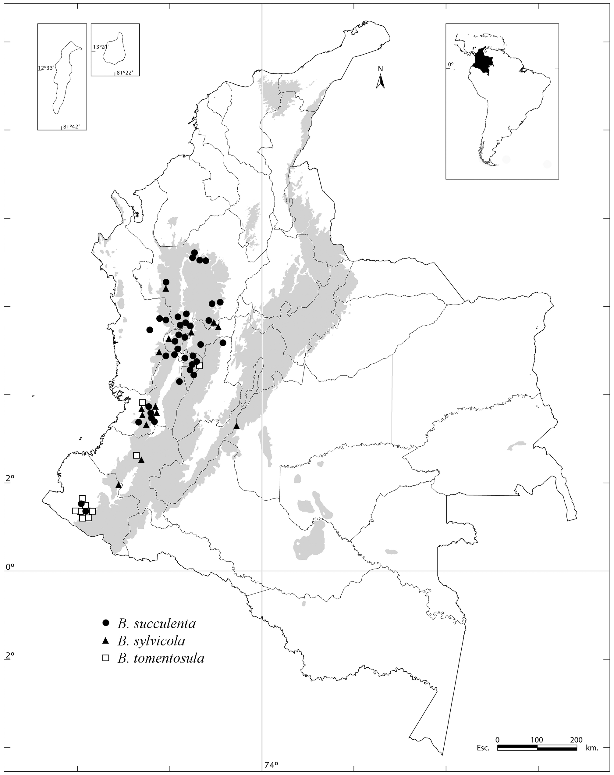
Distribution, ecology and conservation status: — Burmeistera sylvicola is restricted to Colombia. It occurs in cloud Andean forests of the Western and Central cordilleras, and the southern Andean massif, at elevations between 900 and 2500 m, in the departments of Antioquia, Caldas, Cauca, Chocó, Nariño, Risaralda, and Valle del Cauca, with a disjunct record at the Eastern Cordillera, in the department of Meta. Following the IUCN (2022) Guidelines, this species qualifies for the Near Threatened (NT) category.
Notes: — Burmeistera sylvicola is similar to B. breviflora , B. longifolia and B. obtusifolia , from which it differs by the petiole 2–3.5 cm long, and the leaf blade 12–22 × 4–12 cm, with 12 to 16 pairs of secondary veins and an intramarginal vein ( versus the petiole 2–8(–18) mm long, and the leaf blade 4–11 × 1.3–5.0 cm, with 5 to 10 pairs of secondary veins, and lacking an intramarginal vein in the remaining three species).
Additional specimens examined:— Antioquia. Urrao, PNN Las Orquídeas, La Lola, Río Calles , 1320 m, 14 Jun 1981 (fl), L. Albert et al. 1650 ( HUA) ; Urrao, road to Pabón , 24 km S of Urrao-Betulia road, 31 Oct 1987 (fl), A. Brant et al. 1561 ( HUA) ; Frontino-Urrao, PNN Las Orquídeas, camino Calles – Carauta, 1200‒1540 m, 3 Dec 1986 (fl), R. Callejas et al. 3058 ( HUA) ; San Luís, Piedra de Castrillón , 3‒4 hours on foot S of town, 1500‒1700 m, ca. 6°01´N, 75°01´W, 8 May 1989 (fl), D. Daly 5905 ( HUA, NY) GoogleMaps ; Nariño, paraje Paramitos, 2200 m, 17 Jul 1951 (fl, fr), L. Uribe 2148 ( COL). Caldas. Samaná, corregimiento Florencia, Parque Nacional Natural Selva de Florencia , camino a Pensilvania, 5°31´N, 75°2´W, 1800‒1850 m, 19 Oct 2013 (fl, fr), J. Betancur et al. 18247 ( COL). GoogleMaps Cauca. “Cauca valley”, Río Sucio , 27 Jun 1922 (fl), F. Pennell et al. 7229 ( GH, NY) ; “ Cauca valley”, Río Ortega, 1500‒1700 m, 27 Jun 1922 (fl, fr), F. Pennell et al. 7240 ( NY) ; Río Ortega , north of Tambo , 1900‒2100 m, 2 Jul 1922 (fl, fr), F. Pennell et al. 8063 ( GH, NY). Chocó. San José del Palmar, vereda Portachuelo, finca Barrio Blanco , 1300 m, 15 Jan 1983 (fl, fr), S. Díaz 3600 ( COL) ; San José del Palmar, reserva Galápagos , 2200‒2500 m, 31 May 2008 (fl, fr), J. Garzón et al. 480 ( COL). Meta. Between Paso de las Cruces and Buenavista, drainage of río Tigre , Colombia-Uribe trail, 25 km ESE of Colombia, 3º16´N, 74º37´W, 1850 m, 24 Dec 1942 (fl), F. Fosberg 19555 ( NY). GoogleMaps Nariño. Leyva, Plan del Oso , W de la cabecera municipal, 31 Aug 1991 (fl), B. Ramírez 4124 ( PSO). Risaralda. Pueblo Rico, Montebello, Parque Nacional Tatamá, Montezuma Rainforest Reserve and Ecolodge, western slopes of the Cordillera Occidental, cuenca Río Taiba , camino de Los Monos, 1800 m, 5°12´51´´N, 76°4´21´´W, 5 May 2013 (fl), J. Clark et al. 13218 ( COL). GoogleMaps Valle del Cauca. Cali , corregimiento Villa Carmelo, 1200 m, Jun 1980 (fl, fr), C. Amaguaña s.n. ( CUVC) ; Cali , arriba de Villa Carmelo, 1800‒2500 m, 29 Jan 1977 (fl, fr), M. Barreto s.n. ( CUVC) ; along Cali-Buenaventura Hwy at km 29, disturbed virgin cloud forest, 03°28´N, 76°39´W, 12 Feb 1990 (fl, fr), T. Croat et al. 70506 ( CUVC) GoogleMaps ; vicinity Queremal , vereda La Victoria, just S of Queremal, 03°31´06´´N, 76°42´57´´W, 1450‒1480 m, 27 Jul 1997 (fl), T. Croat et al. 80415 ( CUVC) GoogleMaps ; Finca Zingara, on road from km 18 on Cali-Buenaventura Highway to Dapa, 4 km N of main highway, 03°32´35´´N, 76°36´ W, 1900‒2100 m, 5 Aug 1997 (fr), T. Croat et al. 80637 ( CUVC) GoogleMaps ; Cordillera Occidental, vertiente occidental, hoya del río Digua, Piedras de Moler , 900‒1180 m, 19–28 Aug 1943 (fl), J. Cuatrecasas 15126 ( CUVC): Cordillera Occidental, vertiente oriental, Hoya del río Cali , Río Pichindé en la Quebrada de Juntas , 2100 m, 22 Jul – 7Aug 1946 (fl), J. Cuatrecasas 21617 ( VALLE), Cordillera Occidental, Hoya del río Digua , quebrada del río San Juan , arriba de Queremal , Las Colonias, 1950‒2050 m, 20 Mar 1947 (fl), J. Cuatrecasas 23890 ( VALLE) ; Cordillera Occidental, 2‒6 km N of Cali-Buenaventura highway, Finca Zungara and roadside, 3°32´N, 76°35´W, 1900‒1960 m, 24 Mar 1986 (fl), A. Gentry et al. 53574 ( CUVC) GoogleMaps ; La Cumbre, 1700‒2100 m, 9 Sep 1922 (fl), E. Killip et al. 11164 ( NY) ; La Cumbre, cerro de Yumbillo, corregimiento Bitaco , vereda La Sofía, 1900 m, 21 Aug 1988 (st), M. Klimkiewicz 39 ( CUVC) ; La Cumbre, cerro de Yumbillo, corregimiento Bitaco, vereda La Sofía, 5 Oct 1988 (fr), M. Klimkiewicz 135 ( CUVC) ; Campamento Tokio ( Telecom towers), above town of Queremal , 2000‒2075 m, 22 Apr 1979 (fl, fr), J. L. Luteyn et al. 7368 ( COL) ; La Elvira, finca Zingara , 1800‒2200 m, ca. 25 km W of Cali at km 18, ca. 3º28´N, 76º37´W, 19 Apr 1989 (fl, fr), J. L. Luteyn et al. 12525 ( CUVC, NY), 12526 ( CUVC, NY), 12530 ( CUVC, NY) GoogleMaps ; La Elvira, finca Zingara , 1700‒ 1600 m, ca 25 km W of Cali at km 18, ca. 3°28´N, 76°37´W, 20 Apr 1989 (fl, fr), J. L. Luteyn et al. 12559 ( CUVC), 12568 ( CUVC) GoogleMaps ; La Cumbre, vereda Chicoral Alto, above Dapa , ca. 3º39´N, 76º35´W, 1940‒2000 m, 22 Apr 1989 (fl), J. L. Luteyn et al. 12629 ( NY) GoogleMaps ; La Cumbre, 1800‒2000 m, 7–10 May 1922 (fl, fr), F. Pennell 5148 ( NY) ; La Cumbre, 1800‒2100 m, 14–19 May 1922 (fl, fr), F. Pennell et al. 5773 ( GH, NY) ; La Cumbre, 2000 m, vereda Chicoral Alto, detrás de Dapa, nacimientos del río Bitaco , vertiente del Pacífico, 13 Jan 1990 (fl), J. Ramos 2399 ( CUVC, NY) ; Cali , km 23 de la vía al mar, 1600 m, 9 Apr 1978 (fl, fr), M. Santiago s.n. ( CUVC) ; Reserva Natural Hato Viejo, Parque Nacional Farallones de Cali, Eastern slopes of Cordillera Occidental, 2200 m, Jul 1994 (fl), U. Schmitt 114 HV ( COL): Cali, Peña Blanca, without date (fl), Soto Herrera 907 ( VALLE) ; cerro Horqueta, San Antonio above Cali , c. 3º25´N, 76º35´W, 2050‒2200 m, 20 Jan 1986 (fl), B. Stein et al. 3233 ( NY) GoogleMaps ; Cali, Finca Zingara, at km 18 road Cali-Buenaventura , 1900‒2100 m, 25 Jan 1988 (fl, fr), H. van der Werff et al. 9734 ( CUVC).

| F |
Field Museum of Natural History, Botany Department |
| W |
Naturhistorisches Museum Wien |
| G |
Conservatoire et Jardin botaniques de la Ville de Genève |
| L |
Nationaal Herbarium Nederland, Leiden University branch |
| HUA |
Universidad de Antioquia |
| S |
Department of Botany, Swedish Museum of Natural History |
| A |
Harvard University - Arnold Arboretum |
| R |
Departamento de Geologia, Universidad de Chile |
| NY |
William and Lynda Steere Herbarium of the New York Botanical Garden |
| COL |
Universidad Nacional de Colombia |
| J |
University of the Witwatersrand |
| GH |
Harvard University - Gray Herbarium |
| B |
Botanischer Garten und Botanisches Museum Berlin-Dahlem, Zentraleinrichtung der Freien Universitaet |
| PSO |
Universidad de Nariño |
| C |
University of Copenhagen |
| CUVC |
Universidad del Valle |
| M |
Botanische Staatssammlung München |
| T |
Tavera, Department of Geology and Geophysics |
| N |
Nanjing University |
| VALLE |
Universidad Nacional de Colombia |
| E |
Royal Botanic Garden Edinburgh |
| U |
Nationaal Herbarium Nederland |
| H |
University of Helsinki |
No known copyright restrictions apply. See Agosti, D., Egloff, W., 2009. Taxonomic information exchange and copyright: the Plazi approach. BMC Research Notes 2009, 2:53 for further explanation.
|
Kingdom |
|
|
Phylum |
|
|
Class |
|
|
Order |
|
|
Family |
|
|
Genus |
Burmeistera sylvicola Zahlbr., Repert.
| González, Favio 2023 |
Burmeistera sylvicola
| Zahlbr. 1915: 532 |