
Ostorhinchus cheni ( Hayashi, 1990 )
|
publication ID |
https://doi.org/10.12782/sd.22_225 |
|
persistent identifier |
https://treatment.plazi.org/id/6D37F922-967B-FFB0-FC78-04EEFE0AFB9E |
|
treatment provided by |
Felipe (2021-11-29 23:16:16, last updated by Plazi 2023-11-08 08:52:49) |
|
scientific name |
Ostorhinchus cheni ( Hayashi, 1990 ) |
| status |
|
Ostorhinchus cheni ( Hayashi, 1990) View in CoL
( Figs 1–4 View Fig View Fig View Fig View Fig ; Table 1)
Material examined. USNM 212791, 104.5 mm SL, Sri Lanka, 14 January 1970, C . Koenig; KAUM –I. 69457, 115.4 mm SL, off Miagao , Panay Island, Philippines, 10°37′N, 122°14′E, 2 March 2015 GoogleMaps .
Description. Meristics and morphometrics of the specimens are shown in Table 1. Vertebrae 10+14. Formula for supraneural bones, anterior neural spines and anterior dorsal pterygiophores 0/0/0+1/1+1/1/1/1+1/.
Body oval, moderately deep and compressed; deepest at first dorsal-fin origin. Dorsal profile of head and body convex from snout tip to caudal-fin base. Ventral profile of head and body convex from lower jaw to end of caudal-fin base. Caudal peduncle moderately deep. Head large, compressed. Eye large, rounded. Mouth moderate in size, oblique, forming angle of ca. 40° to horizontal axis of body. Posterior tip of maxilla extending beyond vertical through posterior margin of pupil. Upper-jaw length less than half head length. No enlarged caniniform teeth on jaws. A tooth band on both upper and lower jaws. Villiform teeth in 4–5 rows on vomer, 2–3 rows each on palatine. Anterior nostril with a short oval tube, uppermost margin of opening level with ventral margin of pupil. Posterior nostril oval, opening vertically, uppermost margin below level of dorsal margin of pupil. Posterior margins of preopercle and opercle serrated. Gill rakers slender, moderately long. Gill filaments shorter than gill rakers. Scales ctenoid. Lateral line well developed, extending from upper end of gill opening to caudal-fin base.
First dorsal-fin origin anterior to vertical through uppermost part of pectoral-fin base; fourth spine longest. Posterior end of membrane associated posteriorly with last dorsal-fin spine anterior to vertical through posterior tip of depressed pelvic fin. Second dorsal-fin origin anterior to vertical through anal-fin origin; first soft ray of second dorsal fin longest (broken in USNM 212791); all dorsal-fin soft rays branched. Posterior end of second dorsal-fin base anterior to vertical through base of sixth soft ray of anal fin. Analfin origin below base of second soft ray of second dorsal fin; first spine of anal fin much shorter than second. Pectoral fin extending beyond vertical through fourth soft ray base of second dorsal fin. Pelvic-fin origin anterior to vertical through uppermost part of pectoral-fin base. Posterior tip of depressed pelvic fin extending beyond vertical through first spine base of second dorsal fin. Caudal fin forked, lobes pointed. Anus anterior to anal-fin origin.
Fresh coloration —Based on a color photograph of KAUM–I. 69457, 115.4 mm SL, off Miagao, Panay Island, Philippines ( Fig. 1 View Fig ). Head and body silvery-pink, with two blackish-golden stripes, lower stripe from snout to mid-caudal peduncle and upper stripe from dorsal margin of orbit to upper part of caudal peduncle; upper stripe darker than lower stripe; both stripes bordered by narrow, pale lines above and below; those of mid-lateral stripe continue anteriorly as narrow silvery stripes above and below pupil. Bases of first and second dorsal fins blackish-golden. Black blotch on caudal-fin base. Small poorly-defined blackish-golden blotch behind opercle, touching dorsal edge of mid-lateral stripe. First dorsal fin pink, inter-spinous membrane from third spine posteriorly with a blackish band distally; narrow yellow line along most of posterior edge of third spine. Second dorsal and anal fins pink, with broad reddish bands across fin rays at mid fin depth and distally. A thin yellowish stripe along base of anal fin. Pectoral fin translucent. Pelvic fin pink. Caudal fin pink, outer upper and lower procurrent rays yellowish distally.
Coloration of preserved specimens —Head and body pale tan; faded darkish stripes and markings persistent on head and body ( Fig. 2 View Fig ).
Coloration in life —Based on underwater photograph taken at Bali, Indonesia ( Fig. 3 View Fig ). Head and body silveryorange, with three golden dusky stripes: upper stripe from middle of head, between eyes, and along base of dorsal fins reaching at least to end of second dorsal-fin base, middle stripe from dorsal margin of orbit to upper part of caudal peduncle, lower stripe from snout to middle of caudal peduncle. Fluorescent blue stripes radiating from snout. Large black blotch on caudal-fin base. Small poorly-defined black blotch behind opercular margin. First dorsal fin silvery-orange, membrane between third to fifth spines blackish-gold. Other fins silvery-orange. Edge of pelvic fin narrowly whitish.
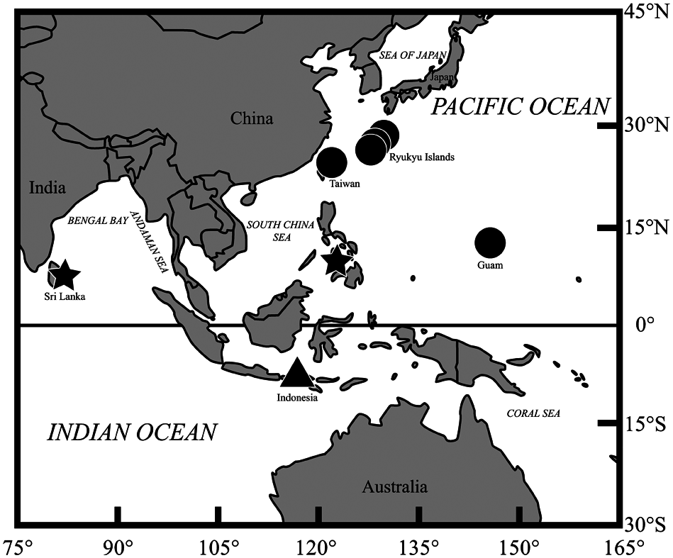
Distribution and habitat. As shown in Fig. 4 View Fig , O. cheni has been recorded from the following Indo-West Pacific localities: Sri Lanka (this study; Fig. 2 View Fig ); Guam, Mariana Islands ( Myers 1999); Panay Island, Visayas Islands, Philippines (this study; Fig. 1 View Fig ); Hou-bi-hu, Hsio-liu-chiu, and Hengchun, Pingtung, Taiwan ( Hayashi 1990; Yoshida and Motomura 2017); and Ie-jima island, Okinawa Islands, Amami-oshima island, Amami Islands, and Iou-jima island, Osumi Islands, Japan ( Hayashi 1990; Yoshida 2013; Yoshida and Motomura 2017). Underwater photograph of O. cheni have been taken at Tulamben, Bali, Indonesia (this study; Fig. 3 View Fig ).
The collection data for the preserved specimens indicates capture depths of 70–100 m ( Hayashi 1990; Yoshida 2013; Yoshida and Motomura 2017). The underwater photograph was taken over a coral reef at a depth of 70– 80 m.
Remarks. The present Sri Lankan and Philippines specimens were identified as Ostorhinchus cheni on the basis of the following character combination: dorsal-fin rays VII-I, 9; pectoral-fin rays 14; gill rakers 5–6+16=21–22; two blackish golden stripes from snout to mid caudal peduncle and from dorsal margin of orbit to upper part of caudal peduncle; black blotch, its size less than pupil diameter, on caudal-fin base; and small poorly-defined black blotch behind opercular margin ( Hayashi 1990; Yoshida and Motomura 2017).
Meristic and morphometric values for the present specimens agreed well with the ranges for the O. cheni holotype and non-type specimens given by Yoshida and Motomura (2017) ( Table 1). The unique Indian Ocean specimen ( Sri Lanka) differed slightly in morphometrics from the western Pacific specimens ( Japan, Taiwan, and Philippines) as follows: caudal-peduncle depth 16.2% SL (vs. 14.1–15.9% in the latter) and pectoral-fin length 27.3% SL (vs. 26.0–26.8%) ( Table 1) . Although these minor differences are regarded here as intraspecific variations, additional specimens from the Indian Ocean should indicate whether or not the Indian and Pacific ocean populations are distinct .
The underwater photograph of a live individual of O. cheni ( Fig. 3 View Fig ) revealed that the species has fluorescent blue stripes radiating from the snout when alive. Such stripes are probably quickly lost after death as they were not apparent even in fresh specimens.
Ostorhinchus cheni was previously known only from Japan, Taiwan, and Guam. The present specimens from Sri Lanka and the Philippines, and the photographic record from Indonesia suggest a much wider distribution of O. cheni in the Indo-West Pacific region.
Ostorhinchus cheni resembles O. doederleini in overall body appearance and coloration, but differs in having a small black blotch behind the opercular margin (vs. blotch absent in the latter) and 14 pectoral-fin rays [vs. 14 or 15 (mode 15)], and lacking a black stripe from the ventral margin of the orbit to the lower part of the caudal peduncle (vs. stripe present) ( Yoshida and Motomura 2017; number of pectoral-fin rays of O. doederleini , 14 in 3 specimens and 15 in 48 specimens in this study). Examination of 51 examples of the former (see Comparative material examined) revealed that gill raker numbers in O. cheni tend to be higher [developed gill rakers 16 or 18 vs. 11–16 (mode 14) in O. doederleini ; gill rakers including rudiments 21 or 22 vs. 17–21 (19)]. Although O. cheni is also similar to O. fukuii ( Hayashi, 1990) in general coloration, it is distinguished from O. fukuii by having a small black blotch behind the opercular margin (vs. blotch absent in the latter) and a black blotch, its size less than pupil diameter, at the caudal-fin base (vs. greater than pupil diameter) ( Yoshida and Motomura 2017; this study).
Comparative material examined. Ostorhinchus doederleini : 51 specimens, 83.0– 106.6 mm SL, all from Japan. SHIKOKU: KAUM–I. 81944, 98.7 mm SL, Nida , Kochi, 33°30′54″N, 133°35′32″E, 3 m, M GoogleMaps . Matsunuma , 2 July 2016; KAUM –I . 81951, 93.2 mm SL, Urado Bay , Kochi, 33°29′54″N, 133°33′59″E, 2 m, M GoogleMaps . Matsunuma , 4 July 2016 . WESTERN KYUSHU: CAS 106513 About CAS , holotype of O . doederleini, 96.2 mm SL, Nagasaki; KAUM –I . 16217, 83.6 mm SL, KAUM–I. 16218, 91.4 mm SL, KAUM–I. 16219, 86.5 mm SL, Kurose Port, Kasasa, Minami-satsuma , Kagoshima, 31°22′29″N, 130°10′06″E, 2–5 m, M GoogleMaps . Meguro and T . Yoshida , 15 March 2009; KAUM –I . 57756, 97.9 mm SL, KAUM–I. 57757, 94.8 mm SL, KAUM–I. 57758, 97.3 mm SL, KAUM–I. 57759, 102.2 mm SL, Tomioka Port, Reihoku , Kumamoto, 32°31′22″N, 130°02′07″E, 1 m, M GoogleMaps . Matsunuma , 29 November 2013; KAUM –I . 65211, 105.3 mm SL, off Hirao, Nagashima, Naga-shima island , Nagashima Islands , Kagoshima, 32°12′48″N, 130°07′31″E, 20–30 m, Y GoogleMaps . Fukui and R . Hirata , 13 July 2014 . KOSHIKI ISLANDS: KAUM–I. 79643, 85.4 mm SL, off Ichinoura, Sato, Satsumasendai , Kamikoshiki-shima island , 31°51′42″N, 129°55′29″E, 1–3 m, K GoogleMaps . Koeda et al ., 16 October 2015; KAUM –I . 89783, 84.0 mm SL, Sato Port, Sato, Satsumasendai , Kamikoshikishima island , 31°50′33″N, 129°55′16″E, 5 m, KAUM fish team, 18 June 2016 GoogleMaps . KAGOSHIMA BAY: KAUM – I . 1227, 88.7 mm SL, Hamamachi , 31°36′06″N, 130°34′17″E, 3 m, G GoogleMaps . Ogihara , 14 November 2006; KAUM –I . 24787, 94.1 mm SL, Taniyama Port , 31°30′04″N, 130°32′03″E, 2 m, Y GoogleMaps . Haraguchi , 12 December 2009; KAUM –I . 96949, 89.1 mm SL, Yamagawa Port, Ibusuki , 31°12′26″N, 130°38′11″E, 5 m, T GoogleMaps . Yoshida et al ., 22 November 2016. EASTERN KYUSHU: KAUM–I. 24847, 83.8 mm SL, KAUM–I. 24848, 83.0 mm SL, off Myoutoura, Nango, Nichinan , Miyazaki, 31°29′N, 131°23′E, 8 m, H GoogleMaps . Kaneko and M . Yamashita , 23 December 2009; KAUM –I . 63888, 95.6 mm SL, KAUM–I. 63889, 93.6 mm SL, Uchinoura, Kimotsuki , Kagoshima, 31°16′38″N, 131°04′59″E, K GoogleMaps . Koeda et al ., 26 May 2014. OSUMI ISLANDS: KAUM–I. 11124, 93.3 mm SL, Ambo Port, Ambo, Yaku-shima island , 30°19′01″N, 130°39′32″E, 3–4 m, KAUM fish team, 9 August 2008; KAUM –I GoogleMaps . 29158, 97.0 mm SL, KAUM–I. 29159, 93.1 mm SL, south of Ambo Port, Ambo, Yaku-shima island , 30°18′44″N, 130°39′28″E, 4–6 m, M GoogleMaps . Matsunuma and M . Meguro , 7 May 2010; KAUM –I . 29402, 103.3 mm SL, Iou-jima Port, Iou-jima island , 30°46′43″N, 130°16′43″E, 3–8 m, KAUM fish team, 24 May 2010; KAUM –I GoogleMaps . 30574, 106.6 mm SL, KAUM–I. 30575, 100.7 mm SL, KAUM–I. 30576, 106.4 mm SL, KAUM–I. 30577, 98.9 mm SL, KAUM–I. 30578, 100.6 mm SL, Take-shima island , 30°49′03″N, 130°25′11″E, 3 m, G GoogleMaps . Ogihara and T . Yoshida , 26 June 2010; KAUM –I . 31700, 102.6 mm SL, Take-shima island , 30°49′03″N, 130°25′11″E, 5–10 m, M GoogleMaps . Meguro and M . Yamashita , 13 August 2010; KAUM –I . 55921, 89.9 mm SL, Shimama, Minamitane, Tanega-shima island , 30°28′02″N, 130°51′38″E, 1–10 m, M GoogleMaps . Meguro et al ., 2 August 2013; KAUM –I . 56350, 93.9 mm SL, KAUM–I. 56351, 87.4 mm SL, off Nishinoomote Port, Nishinoomote, Tanega-shima island , 30°43′50″N, 130°59′13″E, 4 m, M GoogleMaps . Matsunuma , 19 September 2013; KAUM –I . 56357, 94.5 mm SL, Nishinoomote Port, Tanega-shima island , 30°43′42″N, 130°59′32″E, 0.5 m, M GoogleMaps . Matsunuma , 17 September 2013; KAUM –I . 56366, 96.2 mm SL, KAUM–I. 56367, 91.7 mm SL, KAUM–I. 56368, 86.8 mm SL, KAUM–I. 56369, 91.7 mm SL, off mouth of Koume-gawa River, Nishinoomote, Tanega-shima island , 30°43′37″N, 130°59′38″E, 5 m, S GoogleMaps . Tashiro and T . Yoshida , 18 September 2013; KAUM –I . 58665, 97.4 mm SL, KAUM–I. 58666, 97.9 mm SL, Hamatsuwaki Port, Nokan, Nakatane , Tanegashima island , 30°36′03″N, 130°56′50″E, K GoogleMaps . Kaburagi , 25 January 2014; KAUM –I . 61893, 103.7 mm SL, KAUM–I. 61894, 104.8 mm SL, Nishinoomote Port, Nishinoomote, Tanega-shima island , 30°43′55″N, 130°59′00″E, 2 m, K GoogleMaps . Koeda et al ., 10 June 2014; KAUM –I . 62092, 94.3 mm SL, mouth of Koume River, Sakaemachi, Nishinoomote , Tanega-shima island , 30°43′38″N, 130°59′37″E, 3–4 m, T GoogleMaps . Uejo , 12 June 2014; KAUM –I . 66379, 93.5 mm SL, Nishinoomote Port, Nishinoomote, Tanega-shima island , 30°43′55″N, 130°59′00″E, 2 m, T GoogleMaps . Yoshida et al ., 19 September 2014; KAUM –I . 66417, 94.5 mm SL, Hamatsuwaki Port, Nokan, Nakatane , Tanega-shima island , 30°36′03″N, 130°56′50″E, 3–4 m, K GoogleMaps . Eguchi and T . Inaba , 20 September 2014; KAUM –I . 83743, 99.9 mm SL, Hanasatozaki Fishing Port, Nishinoomote, Tanega-shima island , 30°49′12″N, 130°00′15″E, D GoogleMaps . Ando , 23 November 2015; KAUM –I . 91032, 86.7 mm SL, Hommura Port, Yakushima, Kuchierabu-jima island , 30°27′41″N, 130°11′29″E, 5 m, R GoogleMaps . Miki , 22 August 2016; KAUM –I . 96664, 88.1 mm SL, Nishinoomote Port, Nishimachi, Nishinoomote , Tanega-shima island , 30°44′00″N, 130°59′36″E, 10 m, J-M GoogleMaps . Kim , 22 November 2016 . AMAMI ISLANDS: KAUM–I. 47920, 92.0 mm SL, Chabana Port, northwest coast of Yoron-jima island , 27°02′09″N, 128°24′08″E, 5–6 m, M GoogleMaps . Okamoto , 14 August 2012; KAUM –I . 65910, 86.7 mm SL, Hetono Port, Amagi, Amagi , Tokuno-shima island , 27°48′46″N, 128°53′20″E, 8–10 m, T GoogleMaps . Yoshida , 2 October 2014; KAUM –I . 95082, 89.1 mm SL, Kametoku Old Port, Kametoku, Tokunoshima , Tokuno-shima island , 27°44′29″N, 129°01′30″E, 3 m, I GoogleMaps . Mochida , 23 October 2016 .
Ostorhinchus fukuii : 4 specimens, 23.9–90.4 mm SL, all from Japan . HONSHU: YCM-P 6504, paratype of O. fukuii , 90.4 mm SL, beach at Kii-nagashima , Wakayama, A. Osato, 1 April 1979; YCM-P 9539, holotype of O. fukuii , 87.5 mm SL, coastal water off Ugui, Wakayama, 40 m, S. Fukui, 11 July 1981; YCM-P 25102, paratype of O . fukuii, 73.9 mm SL, Futo Beach, Izu Ocean Park, Shizuoka, 45 m, A . Ono, 5 November 1983; YCM-P 25013, paratype of O. fukuii , 23.9 mm SL, same data as the holotype.
Hayashi, M. 1990. Two new cardinalfish (Apogonidae: genus Apogon) from the Indo-West Pacific. Science Report of the Yokosuka City Museum 38: 7 - 18.
Myers, R. F. 1999. Micronesian reef fishes, a comprehensive guide to the coral reef fishes of Micronesia, 3 rd edition. Coral Graphics, Barrigada, vi + 330 pp.
Yoshida, T. 2013. Apogon cheni. P. 112. In: Motomura, H., Dewa, S., Furuta, K., and Matsuura, K. (Eds) Fishes of Iou-jima and Take-shima islands, Mishima, Kagoshima, Japan. The Kagoshima University Museum, Kagoshima and the National Museum of Nature and Science, Tsukuba. [In Japanese]
Yoshida, T. and Motomura, H. 2017. First record of a rare cardinalfish, Ostorhinchus cheni (Apogonidae), from Amami-oshima Island, Kagoshima Prefecture, southern Japan. Bulletin of the Biogeographical Society of Japan 71: 253 - 258. [In Japanese]
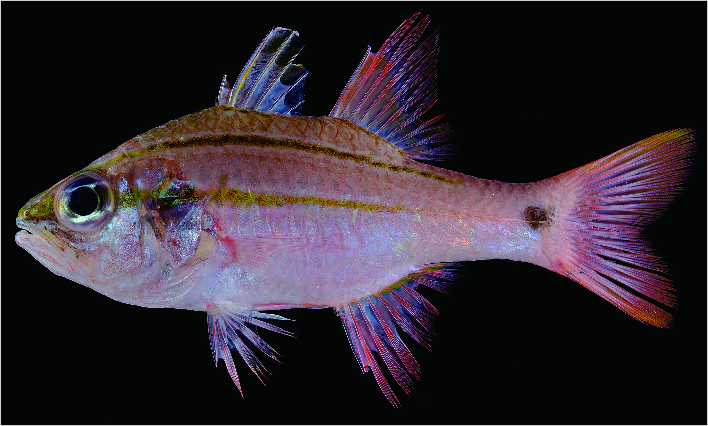
Fig. 1. Fresh specimen of Ostorhinchus cheni. KAUM–I.69457, 115.4mm SL, off Miagao, Panay Island, Philippines.
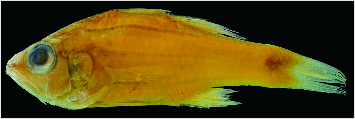
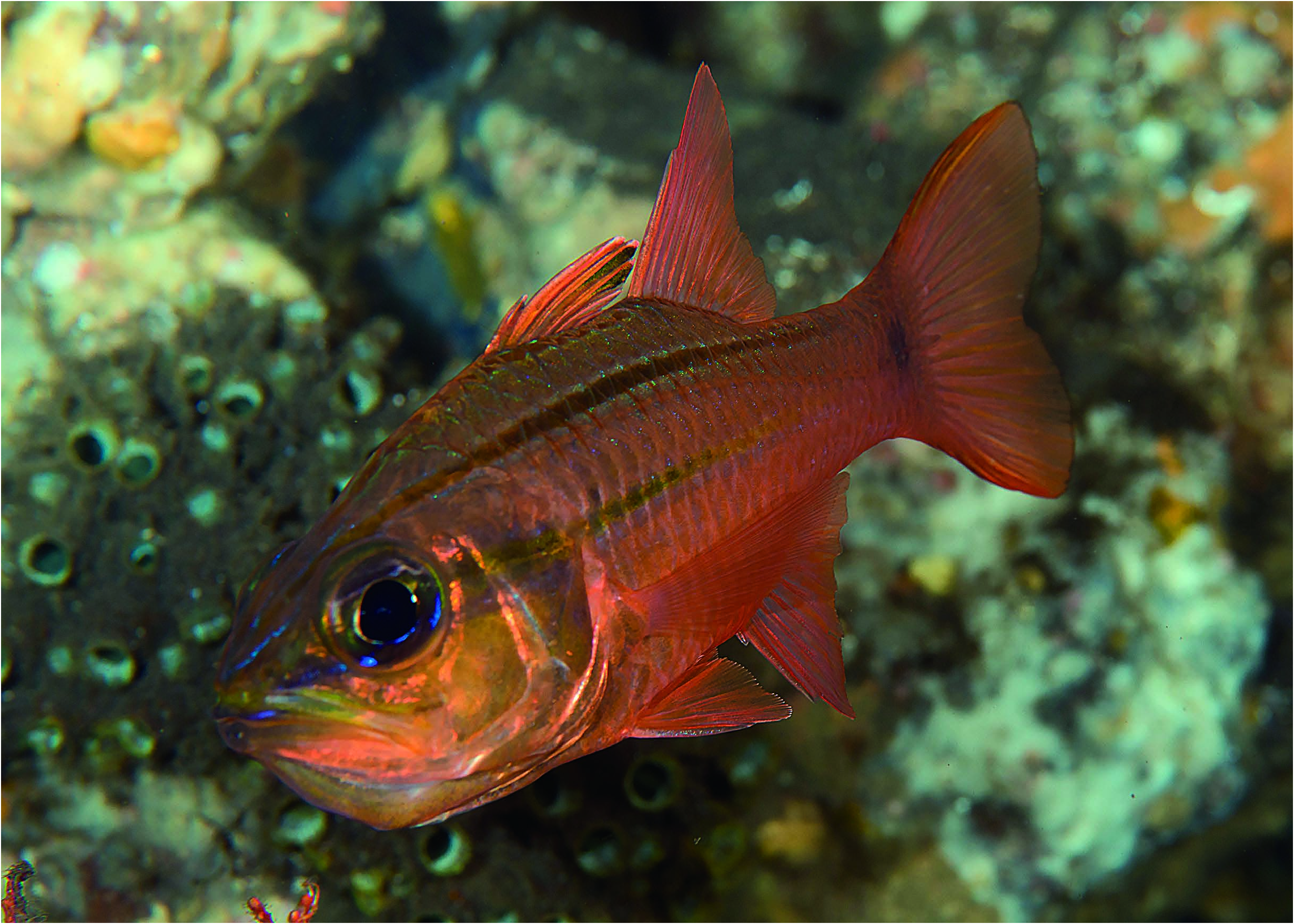
Fig. 3. Underwater photograph of Ostorhinchus cheni. Tulamben, Bali, Indonesia, 70–80m, 18 June 2016 (Photo by T. Shiraishi).
No known copyright restrictions apply. See Agosti, D., Egloff, W., 2009. Taxonomic information exchange and copyright: the Plazi approach. BMC Research Notes 2009, 2:53 for further explanation.
|
Kingdom |
|
|
Phylum |
|
|
Class |
|
|
Order |
|
|
Family |
|
|
Genus |